Middle Wood

Wood, Forest in Somerset

England

Middle Wood

Combe Hay tunnel On the branch line from Limpley Stoke to Camerton and Hallatrow. Part of this branch was used for filming the Titfield Thunderbolt.
Combe Hay tunnel Credit: John Thorn

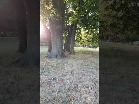
Middle Wood is a stunning woodland located in Somerset, England. Covering an area of approximately 300 acres, it is a prime example of the picturesque natural beauty that the Somerset countryside has to offer. The wood, which is classified as both a wood and a forest, is known for its diverse range of flora and fauna, making it a popular destination for nature enthusiasts and wildlife lovers.

The wood is predominantly made up of deciduous trees, including oak, ash, beech, and birch, which create a dense canopy, providing shelter and habitats for a variety of animals. Visitors can expect to see an array of wildlife, such as deer, badgers, foxes, and numerous species of birds, including woodpeckers and owls.

There are several walking trails throughout the wood, allowing visitors to explore its beauty at their own pace. The trails wind their way through the ancient trees, offering breathtaking views of the surrounding countryside. In addition to the walking trails, Middle Wood also has designated picnic areas, providing the perfect spot to relax and enjoy the peaceful atmosphere.

Middle Wood is also home to a community of eco-friendly log cabins, which offer visitors the opportunity to stay overnight and fully immerse themselves in the tranquility of the woodland. These cabins are equipped with modern amenities, while still maintaining a close connection to nature.

Overall, Middle Wood is a haven of natural beauty, with its diverse wildlife, majestic trees, and serene atmosphere. Whether it's for a leisurely walk, a picnic, or a peaceful getaway, Middle Wood is a must-visit destination for anyone seeking a true connection with nature in the heart of Somerset.

If you have any feedback on the listing, please let us know in the comments section below.
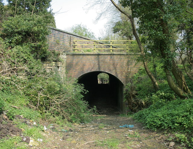
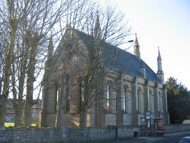
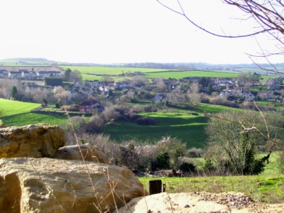
Middle Wood Images

Images are sourced within 2km of 51.354751/-2.3950246 or Grid Reference ST7261. Thanks to Geograph Open Source API. All images are credited.

Combe Hay tunnel On the branch line from Limpley Stoke to Camerton and Hallatrow. Part of this branch was used for filming the Titfield Thunderbolt.
Combe Hay tunnel
On the branch line from Limpley Stoke to Camerton and Hallatrow. Part of this branch was used for filming the Titfield Thunderbolt.
Pink cottage off Combe Hay Lane A view looking to the east across the crossroads on Combe Hay Lane, towards a pink thatched cottage.
Pink cottage off Combe Hay Lane
A view looking to the east across the crossroads on Combe Hay Lane, towards a pink thatched cottage.
2008 : Combe Hay Railway Tunnel Now obviously disused, a view from the same spot taken in 1962 appears in <a href="https://www.geograph.org.uk/photo/349973">ST7259 : Combe Hay tunnel</a>. 
Combe Hay boasted two tunnels, this one which took the railway to the north of the village and the tunnel on the Somerset Coal Canal which ran under the church.
2008 : Combe Hay Railway Tunnel
Now obviously disused, a view from the same spot taken in 1962 appears in ST7259 : Combe Hay tunnel. Combe Hay boasted two tunnels, this one which took the railway to the north of the village and the tunnel on the Somerset Coal Canal which ran under the church.
Junction, Combe Hay Part of the grass triangle at the crossroad west of the village. The junction stands above a tunnel on the former Limpley Stoke to Camerton railway, hence the house in the background is Tunnel House.
Junction, Combe Hay
Part of the grass triangle at the crossroad west of the village. The junction stands above a tunnel on the former Limpley Stoke to Camerton railway, hence the house in the background is Tunnel House.
The Lodge, Combe Hay A cottage orné by the crossroads shown in <a href="https://www.geograph.org.uk/photo/4847450">ST7259 : Junction, Combe Hay</a>, and described at <span class="nowrap"><a title="https://www.historicengland.org.uk/listing/the-list/list-entry/1115365" rel="nofollow ugc noopener" href="https://www.historicengland.org.uk/listing/the-list/list-entry/1115365">Link</a><img style="margin-left:2px;" alt="External link" title="External link - shift click to open in new window" src="https://s1.geograph.org.uk/img/external.png" width="10" height="10"/></span> .
The Lodge, Combe Hay
A cottage orné by the crossroads shown in ST7259 : Junction, Combe Hay, and described at LinkExternal link .
Lane near Combe Hay The lane west of the crossroads shown in <a href="https://www.geograph.org.uk/photo/4847450">ST7259 : Junction, Combe Hay</a>.
Lane near Combe Hay
The lane west of the crossroads shown in ST7259 : Junction, Combe Hay.
Field by Rainbow Wood From the lane between Dunkerton and Combe Hay. Rainbow Wood is the wood at the top of the hill, and is shaped like a narrow crescent, hence the name. The trees on the right border the road shown in <a href="https://www.geograph.org.uk/photo/4899616">ST7259 : Lane near Combe Hay</a>.
Field by Rainbow Wood
From the lane between Dunkerton and Combe Hay. Rainbow Wood is the wood at the top of the hill, and is shaped like a narrow crescent, hence the name. The trees on the right border the road shown in ST7259 : Lane near Combe Hay.
Lane to Combe Hay The lane from Dunkerton curves gradually northwards to meet the lane from Inglesbatch.
Lane to Combe Hay
The lane from Dunkerton curves gradually northwards to meet the lane from Inglesbatch.
Direction Sign - Signpost at the crossroads in Combe Hay Pyramid finial - 4 arms; Somerset SCC pyramid by the UC road, in parish of Combe Hay (Bath And North East Somerset District), on a grass triangle in the centre of the staggered crossroads on Combe Hay Lane.

Surveyed

Milestone Society National ID: SO_ST7259
Direction Sign - Signpost at the crossroads in Combe Hay
Pyramid finial - 4 arms; Somerset SCC pyramid by the UC road, in parish of Combe Hay (Bath And North East Somerset District), on a grass triangle in the centre of the staggered crossroads on Combe Hay Lane. Surveyed Milestone Society National ID: SO_ST7259
The Lodge Cottage at the road junction in Combe Hay.
The Lodge
Cottage at the road junction in Combe Hay.
Benchmark at the Combe Hay Lane crossroads A benchmark of the nineteenth century can be found on the wall in front of the thatched lodge. See <span class="nowrap"><a title="https://www.bench-marks.org.uk/bm142713" rel="nofollow ugc noopener" href="https://www.bench-marks.org.uk/bm142713">Link</a><img style="margin-left:2px;" alt="External link" title="External link - shift click to open in new window" src="https://s1.geograph.org.uk/img/external.png" width="10" height="10"/></span> for the entry in the Benchmark Database and <a href="https://www.geograph.org.uk/photo/6772566">ST7259 : The road to Combe Hay</a> for a location view.
Benchmark at the Combe Hay Lane crossroads
A benchmark of the nineteenth century can be found on the wall in front of the thatched lodge. See LinkExternal link for the entry in the Benchmark Database and ST7259 : The road to Combe Hay for a location view.
The road to Combe Hay Approaching to the village is the crossroads where a thatched lodge stands as part of the old estate. The old canal used to run underneath the actual crossroads and a benchmark was made on the wall here. See <a href="https://www.geograph.org.uk/photo/6772561">ST7259 : Benchmark at the Combe Hay Lane crossroads</a>.
The road to Combe Hay
Approaching to the village is the crossroads where a thatched lodge stands as part of the old estate. The old canal used to run underneath the actual crossroads and a benchmark was made on the wall here. See ST7259 : Benchmark at the Combe Hay Lane crossroads.
The tunnel junction near Combe Hay Apart from marking the start of the Cotswolds, this road junction is actually over a tunnel: it used to be the Somerset Coal Canal and then later a local rail line.
The tunnel junction near Combe Hay
Apart from marking the start of the Cotswolds, this road junction is actually over a tunnel: it used to be the Somerset Coal Canal and then later a local rail line.
Faded railway bridge markings The bridge is actually more like a tunnel, as it used to be a canal first before the railway took over the route. Although both are now long gone, the markings cling on to their past.
Faded railway bridge markings
The bridge is actually more like a tunnel, as it used to be a canal first before the railway took over the route. Although both are now long gone, the markings cling on to their past.
Miles and chains The old units of measurement are still legible on the old bridge. It marks the point of the old canal and later railway being from Camerton and the Dundas Aqueduct.
Miles and chains
The old units of measurement are still legible on the old bridge. It marks the point of the old canal and later railway being from Camerton and the Dundas Aqueduct.
Direction Sign – Signpost on crossroads in Englishcombe parish Located on the northwest side of a crossroads southwest of the village in Englishcombe parish. 3 arms and pyramid finial. See also <a title="https://www.geograph.org.uk/photo/4849161" href="https://www.geograph.org.uk/photo/4849161">Link</a>.

Milestone Society National ID: SO_ST7161
Direction Sign – Signpost on crossroads in Englishcombe parish
Located on the northwest side of a crossroads southwest of the village in Englishcombe parish. 3 arms and pyramid finial. See also Link. Milestone Society National ID: SO_ST7161
Direction Sign – Signpost on Padleigh Hill in Englishcombe parish Located in the village on the northwest side of Padleigh Hill in Englishcombe parish. 1 arm and pyramid finial.

Milestone Society National ID: SO_ST7162
Direction Sign – Signpost on Padleigh Hill in Englishcombe parish
Located in the village on the northwest side of Padleigh Hill in Englishcombe parish. 1 arm and pyramid finial. Milestone Society National ID: SO_ST7162
Fortune Cookie Take Away - Odd Down
Show me another place!

Middle Wood is located at Grid Ref: ST7261 (Lat: 51.354751, Lng: -2.3950246)

Unitary Authority: Bath and North East Somerset

Police Authority: Avon and Somerset

What 3 Words

///salon.tulip.colleague. Near Bath, Somerset

Related Wikis

Duncorn Hill

Duncorn Hill is an English, landmark, rounded hill with a flat top close to the Fosse Way. It is located on a limestone plateau south of Bath in Somerset...

Saint Gregory's Catholic College

Saint Gregory's Catholic College in Odd Down, Bath, England is a Roman Catholic, co-educational secondary school with a sixth form. It was renamed from...

Odd Down A.F.C.

Odd Down Football Club is a football club based in the Odd Down area of Bath, England. They are currently members of the Western League Division One and...

Bath Community Academy

Bath Community Academy (2012–2018), formerly Culverhay School (1956–2012), was a secondary school in the Odd Down area of Bath, England. Built as a boys...

Odd Down

Odd Down is an electoral ward in the City of Bath, England. A suburb of the city, Odd Down is located west and south of the city centre. The city ward...

Englishcombe

Englishcombe is a village and civil parish in Bath and North East Somerset just south-west of Bath, England. The parish, which also includes the hamlets...

St Peter's Church, Englishcombe

The Church of St Peter is the Church of England parish church of Englishcombe, Somerset, England. It is a Grade I listed building. == History == St Peter...

Culverhay Castle

Culverhay Castle, also known as Englishcombe Castle, was a castle in the village of Englishcombe, Somerset, England. == Details == Culverhay Castle was...

Related Videos

City of Bath Somerset England @ NOAH'S TRAVEL S2E53

DAY 4 OF 8 DAYS LONDON VACATION (MARCH 14, 2020) PRES. TRUMP HAD ISSUED A TRAVEL BAN ORDER ON ALL OF ...

Walking To The Fun Fair In Bath, 6 April 2019

Walking to the fun fair at the Royal Victoria Park, Bath, Somerset, 6 April 2019.

Nearby Amenities

Located within 500m of 51.354751,-2.3950246
Barrier: kissing_gate
Lat/Long: 51.3583931/-2.3954351
Barrier: stile
Lat/Long: 51.352112/-2.3979276
Barrier: stile
Lat/Long: 51.3521071/-2.3978008
Barrier: stile
Lat/Long: 51.3547945/-2.3977193
Barrier: stile
Lat/Long: 51.355098/-2.3987869
Power: pole
Lat/Long: 51.3529218/-2.392559
Power: pole
Lat/Long: 51.3530081/-2.3910589
Power: pole
Lat/Long: 51.3530868/-2.3896156
The data included in this document is from www.openstreetmap.org. The data is made available under ODbL.

Have you been to Middle Wood?

Leave your review of Middle Wood below (or comments, questions and feedback).