Covington

Settlement in Huntingdonshire Huntingdonshire

England

Covington

Barn at Nether Dean Nether Dean is not marked on the O.S. map-this location is marked "Lower Dean"
Barn at Nether Dean Credit: Bikeboy

Covington is a small village located in the county of Huntingdonshire, in the East of England. Situated approximately 5 miles southwest of the town of Huntingdon, Covington is nestled in the picturesque countryside, offering residents and visitors a peaceful and idyllic setting.

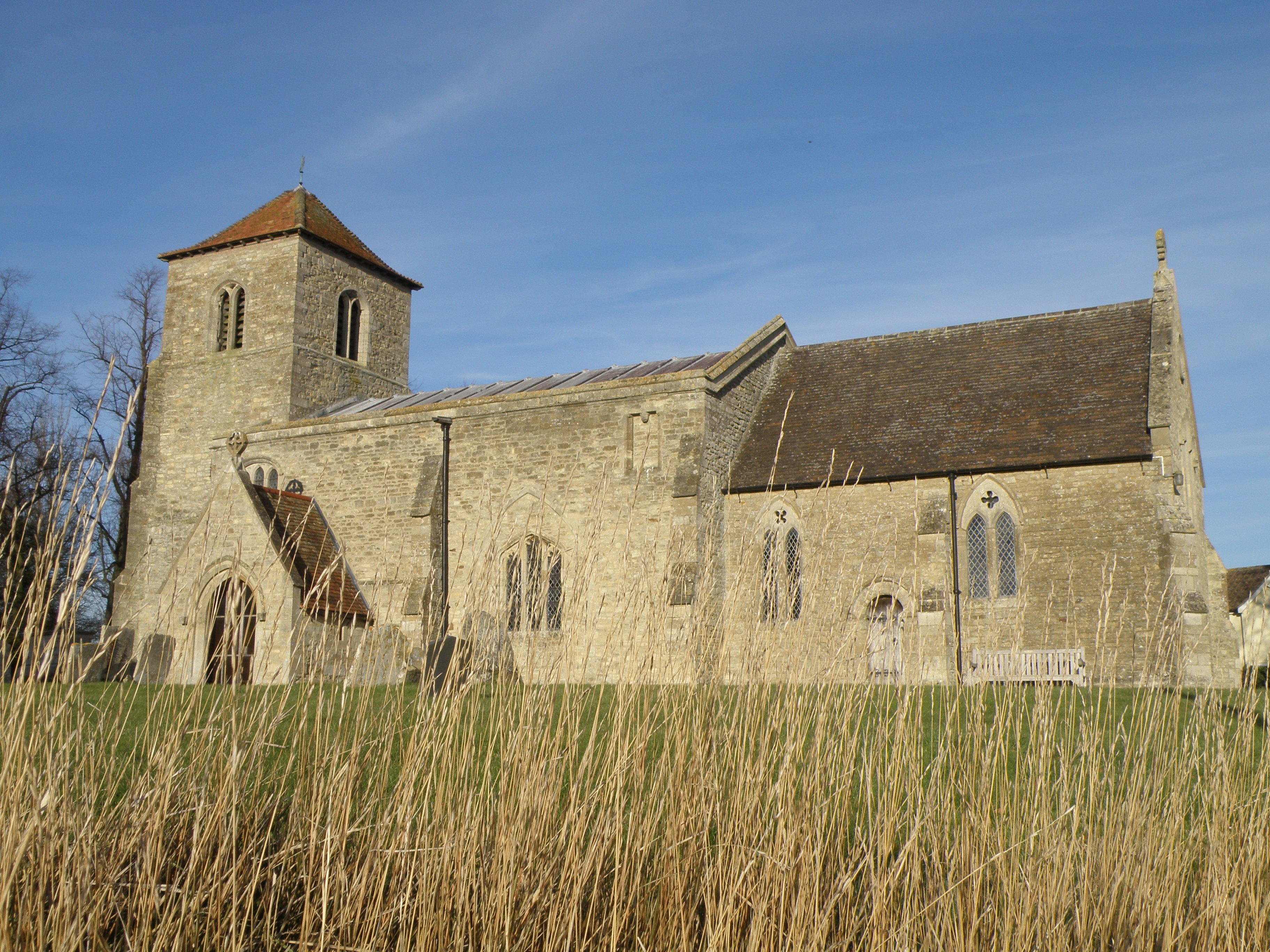
The village is home to a close-knit community, with a population of around 200 people. Covington is renowned for its charming and well-preserved historic buildings, including the beautiful St. Margaret's Church, which dates back to the 12th century. The church is a prominent landmark in the area and attracts visitors interested in its fascinating architecture and rich history.

Despite its small size, Covington offers some amenities for its residents. There is a local pub that serves as a hub for social gatherings and community events, providing a friendly and welcoming atmosphere. The village also has a small primary school, ensuring that families have access to education within their local area.

The surrounding countryside provides ample opportunities for outdoor activities, such as walking and cycling, with numerous scenic trails and paths to explore. The village is also conveniently located close to Grafham Water, a large reservoir renowned for its sailing and fishing opportunities, making it a popular destination for water sports enthusiasts.

Overall, Covington is a charming and peaceful village that offers a close community spirit, historic landmarks, and access to the beautiful countryside, making it an appealing place to live for those seeking a quiet and rural lifestyle.

If you have any feedback on the listing, please let us know in the comments section below.

Covington Images

Images are sourced within 2km of 52.324859/-0.451348 or Grid Reference TL0570. Thanks to Geograph Open Source API. All images are credited.

Barn at Nether Dean Nether Dean is not marked on the O.S. map-this location is marked "Lower Dean"
Barn at Nether Dean
Nether Dean is not marked on the O.S. map-this location is marked "Lower Dean"
Brick Yard Cottage in the trees Of note is the narrow concrete vehicle bridge over the large ditch that provides access to the cottage.
Brick Yard Cottage in the trees
Of note is the narrow concrete vehicle bridge over the large ditch that provides access to the cottage.
Railway infrastructure remains Brick remains of a path access under the former Thrapston Huntingdon railway.
Railway infrastructure remains
Brick remains of a path access under the former Thrapston Huntingdon railway.
Catworth Lodge Viewed from the Three Shires Way.
Catworth Lodge
Viewed from the Three Shires Way.
Former railway infrastructure Brick remains of a path access under the former Thrapston Huntingdon railway.
Former railway infrastructure
Brick remains of a path access under the former Thrapston Huntingdon railway.
Former railway embankment Embankment of the former Thrapston Huntingdon railway. Closed in 1964.
Former railway embankment
Embankment of the former Thrapston Huntingdon railway. Closed in 1964.
Another end of the line An abrupt stop for the Huntingdon Thrapston railway line. Since it closed in 1964 no matter. The land has been returned to arable farming.
Another end of the line
An abrupt stop for the Huntingdon Thrapston railway line. Since it closed in 1964 no matter. The land has been returned to arable farming.
Footbridge for footpath branching off the Three Shires Way Footpath 43/8a to Catworth.
Footbridge for footpath branching off the Three Shires Way
Footpath 43/8a to Catworth.
Grass triangle road junction at Covington On the route of the Three Shires Way.
Grass triangle road junction at Covington
On the route of the Three Shires Way.
Road junction with grass traffic island Road junction on the B654 Raunds to Kimbolton road.
Road junction with grass traffic island
Road junction on the B654 Raunds to Kimbolton road.
All Saints' church Covington The church was also dedicated to St. Margaret at some point. The nave is C11. The first recorded priest was Richard De Baiocis who retired in 1293 (see <span class="nowrap"><a title="http://www.covington.org.uk/gallery/trailmappage.pdf" rel="nofollow ugc noopener" href="http://www.covington.org.uk/gallery/trailmappage.pdf">Link</a><img style="margin-left:2px;" alt="External link" title="External link - shift click to open in new window" src="https://s1.geograph.org.uk/img/external.png" width="10" height="10"/></span> )
All Saints' church Covington
The church was also dedicated to St. Margaret at some point. The nave is C11. The first recorded priest was Richard De Baiocis who retired in 1293 (see LinkExternal link )
All Saints' church Covington and manor house The nave of the church dates from the C11. the manor house dates from 1731 but was built on the site of an ancient moated building.
All Saints' church Covington and manor house
The nave of the church dates from the C11. the manor house dates from 1731 but was built on the site of an ancient moated building.
Ordnance Survey Cut Mark This OS cut mark can be found on the NE face of St Margaret's Church. It marks a point 13.610m above mean sea level.
Ordnance Survey Cut Mark
This OS cut mark can be found on the NE face of St Margaret's Church. It marks a point 13.610m above mean sea level.
All Saints' church, Hargrave The church was built in the second half of C13 but it was almost completely rebuilt between 1868-9.
All Saints' church, Hargrave
The church was built in the second half of C13 but it was almost completely rebuilt between 1868-9.
The former Nags Head pub, Hargrave It was built in C17. Although the pub is gone (it is now a private house), the name lives on in Nags Head Lane.
The former Nags Head pub, Hargrave
It was built in C17. Although the pub is gone (it is now a private house), the name lives on in Nags Head Lane.
Lower Dean TL0669 view to the south
Lower Dean
TL0669 view to the south
Lower Dean Lower Dean telephone box and post box
Lower Dean
Lower Dean telephone box and post box
Three Shires Way Village of Hargrave in the distance.
Three Shires Way
Village of Hargrave in the distance.
Show me another place!

Covington is located at Grid Ref: TL0570 (Lat: 52.324859, Lng: -0.451348)

Administrative County: Cambridgeshire

District: Huntingdonshire

Police Authority: Cambridgeshire

What 3 Words

///nipped.morphing.contents. Near Swineshead, Bedfordshire

Nearby Locations

Covington

Related Wikis

Covington, Cambridgeshire

Covington is a village and civil parish in Cambridgeshire, England. Covington lies approximately 10 miles (16 km) west of Huntingdon near to Catworth and...

Lower Dean

Lower Dean is a village located in the Borough of Bedford in Bedfordshire, England. The village forms part of the Dean and Shelton civil parish (where...

Hargrave, Northamptonshire

Hargrave is a small village and civil parish situated in rural Northamptonshire, England, approximately 21 miles east of Northampton and adjacent to the...

Tilbrook

Tilbrook is a village and civil parish in Cambridgeshire, England. Tilbrook lies approximately 10 miles (16 km) west of Huntingdon, near Covington. Tilbrook...

Nearby Amenities

Located within 500m of 52.324859,-0.451348
Created By: Merkaartor 0.12
Lat/Long: 52.321313/-0.4486379
Created By: Merkaartor 0.12
Lat/Long: 52.3246585/-0.4513942
Cross Street
Naptan AtcoCode: 0500HCOVI001
Naptan Bearing: NE
Naptan BusStopType: CUS
Naptan CommonName: Cross Street
Naptan Indicator: near
Naptan Landmark: Cross Street
Naptan NaptanCode: cmbdmwdj
Naptan ShortCommonName: Keyston Road
Naptan Street: Keyston Road
Naptan Verified: no
Source: naptan_import
Lat/Long: 52.3250016/-0.4514394
Post Box
Post Box Type: lamp
Ref: PE28 74
Lat/Long: 52.3252497/-0.4530658
Power: pole
Lat/Long: 52.3227701/-0.4490608
Power: pole
Lat/Long: 52.3232324/-0.4499862
Power: pole
Lat/Long: 52.3221273/-0.4476714
Power: pole
Lat/Long: 52.3235291/-0.4548439
Power: pole
Lat/Long: 52.3236816/-0.451424
Power: pole
Lat/Long: 52.323429/-0.456888
Power: pole
Lat/Long: 52.3235979/-0.4532344
Information: board
Tourism: information
Lat/Long: 52.3250357/-0.4514192
Telephone
Defibrillator
Booth: K6
Covered: booth
Defibrillator Location: inside red phone box, Keystone Road, Covington
Emergency: defibrillator
Listed Status: Grade II
Man Made: telephone_box
Lat/Long: 52.3251721/-0.4512976
The data included in this document is from www.openstreetmap.org. The data is made available under ODbL.

Have you been to Covington?

Leave your review of Covington below (or comments, questions and feedback).