Cotton End

Settlement in Bedfordshire

England

Cotton End

Airship hangars The old airship hangars at Cardington.  Known as the Royal Airship Works, it built airships for the Admiralty between 1919 and 1930, until the crash of airship R101 stopped all airship work.  It later built barrage balloons for the WW2 effort.
Airship hangars Credit: Bob Walters

Cotton End is a small village located in the county of Bedfordshire, England. Situated just 3 miles south-west of the town of Bedford, it forms part of the Borough of Bedford and falls within the civil parish of Cardington. The village is nestled amidst picturesque countryside, offering residents and visitors a peaceful and scenic environment.

With a population of around 300, Cotton End is a close-knit community that prides itself on its welcoming and friendly atmosphere. The village is known for its traditional character, characterized by its charming thatched cottages and historic buildings. The architecture reflects the village's long history, which dates back to medieval times.

Cotton End benefits from its proximity to Bedford, which provides a range of amenities including shops, restaurants, and leisure facilities. The village also enjoys good transport links, with the A421 road passing nearby, connecting it to the wider area. Additionally, there are regular bus services that connect Cotton End to Bedford and the surrounding towns and villages.

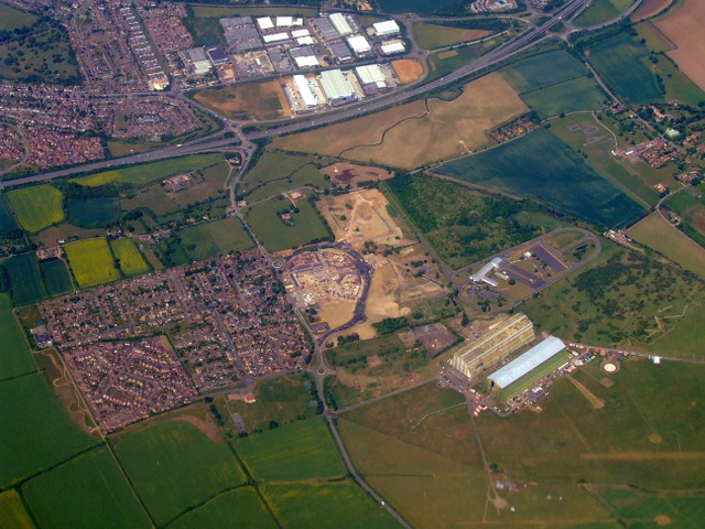
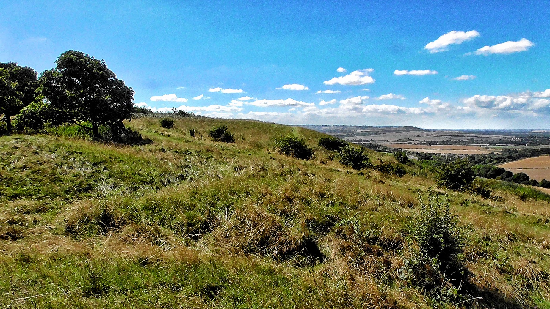
The village is surrounded by beautiful countryside, offering opportunities for outdoor activities and exploration. The nearby Cardington Hangars, notable for their historic significance and grandeur, are a popular attraction for locals and tourists alike.

Overall, Cotton End offers a peaceful and idyllic setting for those seeking a rural lifestyle, with the convenience of nearby amenities and transport links. Its historical charm and natural beauty make it a desirable place to live or visit in the heart of Bedfordshire.

If you have any feedback on the listing, please let us know in the comments section below.

Cotton End Images

Images are sourced within 2km of 52.095354/-0.416097 or Grid Reference TL0845. Thanks to Geograph Open Source API. All images are credited.

Airship hangars The old airship hangars at Cardington.  Known as the Royal Airship Works, it built airships for the Admiralty between 1919 and 1930, until the crash of airship R101 stopped all airship work.  It later built barrage balloons for the WW2 effort.
Airship hangars
The old airship hangars at Cardington. Known as the Royal Airship Works, it built airships for the Admiralty between 1919 and 1930, until the crash of airship R101 stopped all airship work. It later built barrage balloons for the WW2 effort.
Disused railway bridge on Southill Road The old Bedford to Hitchin line of the Midland Railway passed under this bridge near Cardington.  The line was opened in 1857, but became a backwater when the main Bedford to St. Pancras line was built for the Midland's access to London.  it closed in 1963 and the track was removed sometime after 1964.
Disused railway bridge on Southill Road
The old Bedford to Hitchin line of the Midland Railway passed under this bridge near Cardington. The line was opened in 1857, but became a backwater when the main Bedford to St. Pancras line was built for the Midland's access to London. it closed in 1963 and the track was removed sometime after 1964.
Farm track access bridge in old trackbed north of Old Warden Tunnel
Bridleway to Herring's Green Looking south-west from Southill Road near Manor Farm.
Bridleway to Herring's Green
Looking south-west from Southill Road near Manor Farm.
Bedford & District Model Aircraft Club flying field A nicely kept airstrip by the side of a field of beans by Southill Road.
Bedford & District Model Aircraft Club flying field
A nicely kept airstrip by the side of a field of beans by Southill Road.
Bedford & District Model Aircraft Club flying field Off Southill Road near Cardington.
Bedford & District Model Aircraft Club flying field
Off Southill Road near Cardington.
Beans near Cardington A field of broad/field beans emerging near Southill Road, adjacent to the Bedford & District Model Aircraft Flying Club airstrip. The Cardington Airship Sheds can just be seen through the drizzle.
Beans near Cardington
A field of broad/field beans emerging near Southill Road, adjacent to the Bedford & District Model Aircraft Flying Club airstrip. The Cardington Airship Sheds can just be seen through the drizzle.
Track into the enclosure within the moat
Bridleway to Cotton End
Trees round the moat
Farm track under the disused railway embankment
Field with reservoir beyond
Field by Wood End Farm with copse beyond
Cardington airship hangars from the air More information about these monstrous buildings can be found here <a href="https://www.geograph.org.uk/photo/228829">TL0846 : Cardington Airfield Airship Sheds - near Shortstown, Beds</a>.
Cardington airship hangars from the air
More information about these monstrous buildings can be found here TL0846 : Cardington Airfield Airship Sheds - near Shortstown, Beds.
Airship Hangar No. 2 - Interior in 1970 A view from the central staircase on the north side of the hangar looking towards the east end from about 70 feet above floor level. This view was taken shortly after the Fire Research Station (then based at Borehamwood, Herts) leased part of the hangar from the Ministry of Defence for tests on high-rack storage. The racking in the middle distance of the photograph is about 40 feet high, to give some idea of the scale of this building.
For a more recent view see <a href="https://www.geograph.org.uk/photo/2581498">TL0846 : Airship Hangar No. 2 - interior to east end in 1994</a>.
Airship Hangar No. 2 - Interior in 1970
A view from the central staircase on the north side of the hangar looking towards the east end from about 70 feet above floor level. This view was taken shortly after the Fire Research Station (then based at Borehamwood, Herts) leased part of the hangar from the Ministry of Defence for tests on high-rack storage. The racking in the middle distance of the photograph is about 40 feet high, to give some idea of the scale of this building. For a more recent view see TL0846 : Airship Hangar No. 2 - interior to east end in 1994.
Cardington Airship Hangar No. 2 - Interior photo of E end in 1970 Part of the east end of Hangar No. 2 photographed in 1970. We are looking down from the central roof catwalk 163 feet above the floor of the hangar at an experimental high-rack storage system being subjected to fire tests by the Fire Research Station. (See <a href="https://www.geograph.org.uk/photo/2581459">TL0846 : Airship Hangar No. 2 - Interior in 1970</a> for a more general view of the interior.)
Cardington Airship Hangar No. 2 - Interior photo of E end in 1970
Part of the east end of Hangar No. 2 photographed in 1970. We are looking down from the central roof catwalk 163 feet above the floor of the hangar at an experimental high-rack storage system being subjected to fire tests by the Fire Research Station. (See TL0846 : Airship Hangar No. 2 - Interior in 1970 for a more general view of the interior.)
Airship Hangar No. 2 - interior to east end in 1994 Looking towards the east end of the hangar from the south central staircase at about 40 feet above the hangar floor. By this date the whole hangar was in the care of the Building Research Establishment, into which the Fire Research Station had been merged in 1972.
Visible are in the foreground is a 5-storey tower used for investigating fire spread on external building cladding materials; behind and to the right is a gable wall and roof of a two-storey 3-bedroomed detached house, used for looking at problems of domestic fire detectors; mid-right of picture is a calorimeter hood used to measure the heat output of burning furniture and other items; rear centre is an eight-storey steel-framed office block built for fire and other structural tests, and to the left of that is a 707 fuselage used for work for CAA on improving fire resistance of aircraft seating. A view looking in the opposite direction is at <a href="https://www.geograph.org.uk/photo/2581515">TL0846 : Airship Hangar No. 2 - interior view to west in 1994</a>.
(Photo is a scan of a print from a 35mm Agfa slide - see <a href="https://www.geograph.org.uk/photo/2581459">TL0846 : Airship Hangar No. 2 - Interior in 1970</a> for a similar view in 1970.)
Airship Hangar No. 2 - interior to east end in 1994
Looking towards the east end of the hangar from the south central staircase at about 40 feet above the hangar floor. By this date the whole hangar was in the care of the Building Research Establishment, into which the Fire Research Station had been merged in 1972. Visible are in the foreground is a 5-storey tower used for investigating fire spread on external building cladding materials; behind and to the right is a gable wall and roof of a two-storey 3-bedroomed detached house, used for looking at problems of domestic fire detectors; mid-right of picture is a calorimeter hood used to measure the heat output of burning furniture and other items; rear centre is an eight-storey steel-framed office block built for fire and other structural tests, and to the left of that is a 707 fuselage used for work for CAA on improving fire resistance of aircraft seating. A view looking in the opposite direction is at TL0846 : Airship Hangar No. 2 - interior view to west in 1994. (Photo is a scan of a print from a 35mm Agfa slide - see TL0846 : Airship Hangar No. 2 - Interior in 1970 for a similar view in 1970.)
Airship Hangar No. 2 - interior view to west in 1994 View from the central south staircase from about 40feet above hangar floor level. In this view towards the open doors at the west end of the hangar there are two fire test rigs visible. The 'Barrage Balloon' seen left of centre was operated by the Meteorological Office and was used by their scientists based at Cardington to take their instruments up through the atmosphere to around 10,000 feet height. Hidden behind the balloon and its winch lorry and other vehicles is a test rig for looking at the effect of gas explosions on buildings.
Just visible at the apex of the door opening is the underside of a catwalk 163 feet above the hangar floor - the centre of the three large linear objects. On the right of the taller fire test ring can be seen the NW staircase giving access to the centre catwalk and two lower catwalks towards the sides of the hangar. For a view looking the other way see <a href="https://www.geograph.org.uk/photo/2581498">TL0846 : Airship Hangar No. 2 - interior to east end in 1994</a>.
(Photo scanned from a print made from an Agfa 35mm slide.)
Airship Hangar No. 2 - interior view to west in 1994
View from the central south staircase from about 40feet above hangar floor level. In this view towards the open doors at the west end of the hangar there are two fire test rigs visible. The 'Barrage Balloon' seen left of centre was operated by the Meteorological Office and was used by their scientists based at Cardington to take their instruments up through the atmosphere to around 10,000 feet height. Hidden behind the balloon and its winch lorry and other vehicles is a test rig for looking at the effect of gas explosions on buildings. Just visible at the apex of the door opening is the underside of a catwalk 163 feet above the hangar floor - the centre of the three large linear objects. On the right of the taller fire test ring can be seen the NW staircase giving access to the centre catwalk and two lower catwalks towards the sides of the hangar. For a view looking the other way see TL0846 : Airship Hangar No. 2 - interior to east end in 1994. (Photo scanned from a print made from an Agfa 35mm slide.)
Show me another place!

Cotton End is located at Grid Ref: TL0845 (Lat: 52.095354, Lng: -0.416097)

Unitary Authority: Bedford

Police Authority: Bedfordshire

What 3 Words

///pots.inferior.prefect. Near Cardington, Bedfordshire

Nearby Locations

Cotton End

Related Wikis

Eastcotts

Eastcotts is an electoral ward within the Borough of Bedford, in the ceremonial county of Bedfordshire, England. It was formerly also a civil parish until...

Cotton End

Cotton End is a small village and civil parish on the outskirts of Bedford. It became its own parish as of 1 April 2019, having previously been part of...

Herrings Green

Herrings Green is a hamlet in the civil parish of Cotton End, on the outskirts of Bedford, in the Bedford district, in the ceremonial county of Bedfordshire...

Bedfordshire

Bedfordshire (; abbreviated Beds) is a ceremonial and historic county in the East of England. It is bordered by Northamptonshire to the north, Cambridgeshire...

Nearby Amenities

Located within 500m of 52.095354,-0.416097
Bus: yes
Public Transport: stop_position
Lat/Long: 52.0975652/-0.4180965
Cotton End
Place: village
Wikidata: Q1523157
Lat/Long: 52.093979/-0.4172917
Pub
The Bell
Addr City: Cotton End
Addr Country: GB
Addr Housenumber: 61
Addr Postcode: MK45 3AE
Addr Street: High Road
Fhrs Authority: Bedford
Fhrs Id: 1230064
Fhrs Local Authority Id: 130608
Wikidata: Q26407968
Lat/Long: 52.0958189/-0.4173239
Mini Roundabout
Direction: clockwise
Lat/Long: 52.0949411/-0.4183251
Speed Camera
Description: Average Speed Camera 30MPH
Maxspeed: 30 mph
Lat/Long: 52.0911472/-0.4173496
Speed Camera
Description: Average Speed Camera 30MPH
Maxspeed: 30 mph
Lat/Long: 52.0978354/-0.4184141
Post Box
Brand: Royal Mail
Brand Wikidata: Q638098
Collection Times: Mo-Fr 17:15; Sa 11:15
Operator: Royal Mail
Operator Wikidata: Q638098
Post Box Type: lamp
Ref: MK45 105
Royal Cypher: EIIR
Royal Cypher Wikidata: Q33102113
Source: survey
Survey Date: 2016-04-02
Lat/Long: 52.0935301/-0.4148449
Post Box
Brand: Royal Mail
Brand Wikidata: Q638098
Collection Times: Mo-Fr 09:00; Sa 07:00
Operator: Royal Mail
Operator Wikidata: Q638098
Post Box Type: lamp
Ref: MK45 42D
Royal Cypher: EIIR
Royal Cypher Wikidata: Q33102113
Source: survey
Survey Date: 2016-04-02
Lat/Long: 52.0942456/-0.4174828
Mini Roundabout
Direction: clockwise
Lat/Long: 52.0961547/-0.4176711
Barrier: lift_gate
Lat/Long: 52.0965291/-0.4186613
Crossing
Lat/Long: 52.0964649/-0.4185456
Bench
Backrest: no
Material: wood
Lat/Long: 52.0954713/-0.4231806
Addr Country: GB
Addr Housenumber: 131
Addr Street: High Road
Lat/Long: 52.0928176/-0.4184397
Addr Country: GB
Addr Housenumber: 139
Addr Street: High Road
Lat/Long: 52.0926374/-0.4182111
The data included in this document is from www.openstreetmap.org. The data is made available under ODbL.

Have you been to Cotton End?

Leave your review of Cotton End below (or comments, questions and feedback).