Mill Plantation

Wood, Forest in Cheshire

England

Mill Plantation

Audlem Cemetery: memorial marking unmarked pauper graves Between 1876 and 1951 this area was used to bury persons who died too poor to pay for their own funeral and whose burial fees were met by the parish.  The unmarked graves were discovered in 2003 and as a result this monument, listing those commemorated, was erected in 2012.
Audlem Cemetery: memorial marking unmarked pauper graves Credit: Christopher Hilton

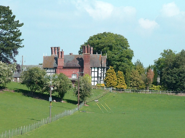
Mill Plantation is a picturesque woodland located in Cheshire, England. Covering an area of approximately 100 acres, it is a thriving example of an ancient forest ecosystem. The plantation is situated near the small village of Mill, making it easily accessible for visitors.

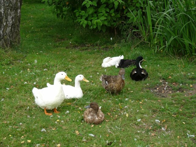
The woodland is predominantly made up of native tree species, including oak, beech, and birch, which provide a rich habitat for a variety of wildlife. The dense canopy of the trees creates a cool and shaded environment, perfect for a leisurely walk or a peaceful picnic.

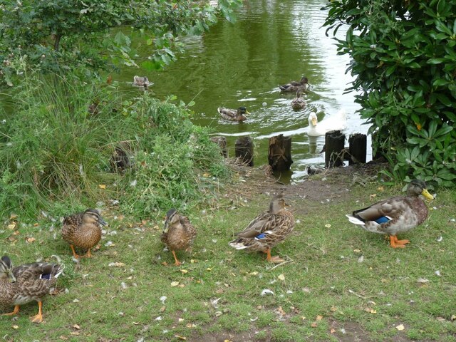
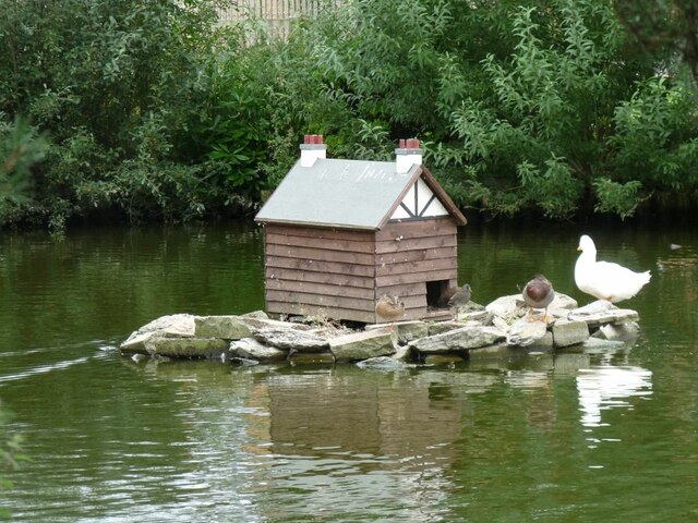
As visitors explore Mill Plantation, they will come across a meandering stream that runs through the heart of the woodland. This stream not only adds to the scenic beauty of the area but also provides a vital water source for the diverse wildlife that calls the woodland home.

The plantation is popular with birdwatchers, as it attracts a wide range of bird species. From the elusive tawny owl to the majestic buzzard, bird enthusiasts have the opportunity to spot and observe these creatures in their natural habitat.

For those interested in history, Mill Plantation has a fascinating past. It was once home to a watermill, which played a significant role in the local community's economy. Although the mill is no longer operational, remnants of the old structure can still be found within the woodland, adding an element of intrigue to the area.

Overall, Mill Plantation, Cheshire is a captivating woodland that offers visitors the chance to immerse themselves in nature, explore its diverse flora and fauna, and discover the remnants of its historical past.

If you have any feedback on the listing, please let us know in the comments section below.

Mill Plantation Images

Images are sourced within 2km of 53.001251/-2.5015072 or Grid Reference SJ6644. Thanks to Geograph Open Source API. All images are credited.

Audlem Cemetery: memorial marking unmarked pauper graves Between 1876 and 1951 this area was used to bury persons who died too poor to pay for their own funeral and whose burial fees were met by the parish.  The unmarked graves were discovered in 2003 and as a result this monument, listing those commemorated, was erected in 2012.
Audlem Cemetery: memorial marking unmarked pauper graves
Between 1876 and 1951 this area was used to bury persons who died too poor to pay for their own funeral and whose burial fees were met by the parish. The unmarked graves were discovered in 2003 and as a result this monument, listing those commemorated, was erected in 2012.
Audlem Cemetery: memorial marking unmarked pauper graves Between 1876 and 1951 this area was used to bury persons who died too poor to pay for their own funeral and whose burial fees were met by the parish. The unmarked graves were discovered in 2003 and as a result this monument, listing those commemorated, was erected in 2012.
Audlem Cemetery: memorial marking unmarked pauper graves
Between 1876 and 1951 this area was used to bury persons who died too poor to pay for their own funeral and whose burial fees were met by the parish. The unmarked graves were discovered in 2003 and as a result this monument, listing those commemorated, was erected in 2012.
Former canal company stables and winding hole, bottom of Audlem locks The Shropshire Union Canal (from Autherley to Nantwich) was engineered by Thomas Telford and opened in 1835. There are long straight sections of this canal which required either embankments or cuttings to avoid the need for locks. Although this was a more difficult procedure, the end route was shorter and the progress for horse drawn working boats could be maintained with (hopefully) no stoppages. The canal (formerly the Birmingham and Liverpool Junction Canal) was opened at a time when railways were making serious inroads into the canal companies' businesses. 

The current Shroppie north of Nantwich was formerly the Chester Canal, opened in 1779, and has wider locks and bridges. Boats up to nine feet in beam can still navigate this section; Telford's canal accommodates only narrowboats up to seven feet in beam.
Former canal company stables and winding hole, bottom of Audlem locks
The Shropshire Union Canal (from Autherley to Nantwich) was engineered by Thomas Telford and opened in 1835. There are long straight sections of this canal which required either embankments or cuttings to avoid the need for locks. Although this was a more difficult procedure, the end route was shorter and the progress for horse drawn working boats could be maintained with (hopefully) no stoppages. The canal (formerly the Birmingham and Liverpool Junction Canal) was opened at a time when railways were making serious inroads into the canal companies' businesses. The current Shroppie north of Nantwich was formerly the Chester Canal, opened in 1779, and has wider locks and bridges. Boats up to nine feet in beam can still navigate this section; Telford's canal accommodates only narrowboats up to seven feet in beam.
Shropshire Union Canal, approaching Audlem lock 14
Ducks on Hankelow Green So used to people that they did not mind being photographed.
Ducks on Hankelow Green
So used to people that they did not mind being photographed.
Ducks on the pond in Hankelow Green Both wild and domesticated birds together.
Ducks on the pond in Hankelow Green
Both wild and domesticated birds together.
Duck House Amusing home for the ducks on an island in the pool on Hankelow Green
Duck House
Amusing home for the ducks on an island in the pool on Hankelow Green
Towpath on Shropshire Union Canal by Audlem The canal run south-east at this point. This section of the Canal is known as the "Main Line" and runs between Nantwich and Autherley Junction. Audlem Mill, a two-storey gift shop, is visible on the left.
Towpath on Shropshire Union Canal by Audlem
The canal run south-east at this point. This section of the Canal is known as the "Main Line" and runs between Nantwich and Autherley Junction. Audlem Mill, a two-storey gift shop, is visible on the left.
Audlem Lock 14 on the Shropshire Union Canal near Audlem The 14th of a flight of 15 locks on the Shropshire Union Canal near Audlem. This section of the Canal is known as the "Main Line" and runs between Nantwich and Autherley Junction.
Audlem Lock 14 on the Shropshire Union Canal near Audlem
The 14th of a flight of 15 locks on the Shropshire Union Canal near Audlem. This section of the Canal is known as the "Main Line" and runs between Nantwich and Autherley Junction.
Former Audlem Police Station Dating from 1901 by the architect Henry Beswick, Cheshire County Architect.
Former Audlem Police Station
Dating from 1901 by the architect Henry Beswick, Cheshire County Architect.
Former Audlem Primitive Methodist Chapel Built in 1871 replacing an earlier chapel on the same site. Open for worship until the 1930s when it merged with the Wesleyan Methodist congregation.
Former Audlem Primitive Methodist Chapel
Built in 1871 replacing an earlier chapel on the same site. Open for worship until the 1930s when it merged with the Wesleyan Methodist congregation.
Moss Hall, Audlem Grade I listed. Listing number 1138519. Manor House. Early 17th century. Timber framed with rendered infill and brick with a plain tile roof. Two storeys with attics. Entrance front: of 5 bays near-symmetrically disposed in E-shaped arrangement.
Moss Hall, Audlem
Grade I listed. Listing number 1138519. Manor House. Early 17th century. Timber framed with rendered infill and brick with a plain tile roof. Two storeys with attics. Entrance front: of 5 bays near-symmetrically disposed in E-shaped arrangement.
Bridge 82 on the Shropshire Union Canal Cool Lane Bridge.
Bridge 82 on the Shropshire Union Canal
Cool Lane Bridge.
Location of bridge 81 on the Shropshire Union Canal Hall's Bridge.
Location of bridge 81 on the Shropshire Union Canal
Hall's Bridge.
Bridge 80 on the Shropshire Union Canal Grade II listed. Listing number 1320256. Accommodation bridge. 1827-30. Telford design. Washed brick, with stoneband and copings. Single elliptical arch. Slightly cambered solid parapet, and piers. 2 iron rope fenders. Brick paved towpath beneath bridge.
Bridge 80 on the Shropshire Union Canal
Grade II listed. Listing number 1320256. Accommodation bridge. 1827-30. Telford design. Washed brick, with stoneband and copings. Single elliptical arch. Slightly cambered solid parapet, and piers. 2 iron rope fenders. Brick paved towpath beneath bridge.
Over Water Marina On the Shropshire Union Canal.
Over Water Marina
On the Shropshire Union Canal.
The Old Stables, Audlem At the bottom of the Audlem lock flight on the Shropshire Union Canal.
The Old Stables, Audlem
At the bottom of the Audlem lock flight on the Shropshire Union Canal.
Audlem: canal bridge and lock 12 beyond
Show me another place!

Mill Plantation is located at Grid Ref: SJ6644 (Lat: 53.001251, Lng: -2.5015072)

Unitary Authority: Cheshire East

Police Authority: Cheshire

What 3 Words

///letters.shuttling.curable. Near Audlem, Cheshire

Related Wikis

Little Heath, Cheshire East

Little Heath is a village in the civil parish of Audlem, Cheshire, England. It is located to the north of Audlem, between Lonk Land and Audlem Road, the...

Ball Farm

Ball Farm is the oldest surviving building in the village of Hankelow, near Audlem in Cheshire, England, and is thought to date from 1510. Most of its...

Hankelow

Hankelow is a village and civil parish in the unitary authority of Cheshire East and the ceremonial county of Cheshire, England. The village lies on the...

Moss Hall, Audlem

Moss Hall, Audlem, is a manor house 0.5 miles (1 km) north-west of Audlem, Cheshire, England. It is recorded in the National Heritage List for England...

Hankelow Hall

Hankelow Hall is a former country house to the north of the village of Hankelow, Cheshire, England. == History == The present house dates from the early...

Audlem Baptist Church

Audlem Baptist Church is in Woore Road, Audlem, Cheshire, England. It is an active Baptist church, and is recorded in the National Heritage List for England...

Audlem

Audlem ( ORD-ləm) is a village and civil parish located in the unitary authority of Cheshire East and the ceremonial county of Cheshire in North West England...

St James' Church, Audlem

St James' Church is in the village of Audlem in south Cheshire, England. It is recorded in the National Heritage List for England as a designated Grade...

Nearby Amenities

Located within 500m of 53.001251,-2.5015072
Barrier: stile
Lat/Long: 53.0010301/-2.4984619
Barrier: kissing_gate
Lat/Long: 52.9979413/-2.5065666
Power: pole
Lat/Long: 52.9968003/-2.5016695
Power: pole
Lat/Long: 52.996965/-2.5030938
Barrier: stile
Material: wood
Step Count: 2
Stile: stepover
Lat/Long: 52.9989482/-2.5071645
Barrier: stile
Lat/Long: 53.0031903/-2.4985498
Bus Stop
Hankelow, Old School Lane / Corbrook Cottages
Bus: yes
Naptan AtcoCode: 0600CRIM1655
Naptan Bearing: NE
Naptan BusStopType: CUS
Naptan CommonName: Corbrook Cottages
Naptan Indicator: o/s
Naptan Landmark: Corbrook Cottages
Naptan LocalityName: Hankelow
Naptan NaptanCode: chewtmp
Naptan ShortCommonName: Corbrook Cottages
Naptan Street: Old School Lane
Network: Cheshire East Council
Operator: Ansa Transport
Public Transport: platform
Source: naptan_import
Lat/Long: 53.001899/-2.496517
Bus Stop
Hankelow, Audlem Road / Corbrook Cottages
Bus: yes
Naptan AtcoCode: 0600CR19262
Naptan Bearing: SW
Naptan BusStopType: CUS
Naptan CommonName: Corbrook Cottages
Naptan Indicator: opp
Naptan Landmark: Corbrook Cottages
Naptan LocalityName: Hankelow
Naptan NaptanCode: cheagamw
Naptan ShortCommonName: Corbrook Cottages
Naptan Street: Audlem Road
Network: Cheshire East Council
Operator: Ansa Transport
Public Transport: platform
Source: naptan_import
Lat/Long: 53.001823/-2.496313
The data included in this document is from www.openstreetmap.org. The data is made available under ODbL.

Have you been to Mill Plantation?

Leave your review of Mill Plantation below (or comments, questions and feedback).