Bowrang Plantation

Wood, Forest in Westmorland Eden

England

Bowrang Plantation

Foresters Hall, Kirkby Thore This has two date stones: 'FORESTERS HALL / No, 844 / 1844'/ UNITAS BENEVOLENTIA ET CONCORDIA, surmounted by a deer's head, and 'ERECTED / BY SUBSCRIPTION / 1832 / scientia millaeres est praestantior'. The hall was first built as a single-storey reading room, according to the listing details.
Foresters Hall, Kirkby Thore Credit: Humphrey Bolton

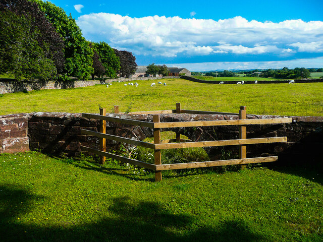
Bowrang Plantation is a sprawling forested area located in Westmorland, a picturesque region in the Wood district of England. This plantation is known for its abundant and diverse range of trees, making it a popular destination for nature enthusiasts and hikers alike.

Covering an area of approximately 500 hectares, Bowrang Plantation is home to a mix of deciduous and coniferous trees, including oak, beech, pine, and spruce. The dense forest canopy provides a haven for a variety of wildlife, including deer, squirrels, and numerous species of birds.

The plantation offers several well-maintained walking trails, allowing visitors to explore its natural beauty and immerse themselves in the peaceful surroundings. The trails are suitable for all levels of fitness, with options for short walks as well as longer hikes that take you deeper into the forest.

In addition to its natural charm, Bowrang Plantation is also known for its sustainable management practices. The forest is carefully managed to ensure the preservation of its ecosystem and the long-term health of its trees. This includes selective logging and reforestation efforts to maintain a balanced and thriving woodland.

Visitors to Bowrang Plantation can enjoy a tranquil day out in nature, surrounded by towering trees and the soothing sounds of wildlife. Whether it's a leisurely stroll, a picnic by the picturesque streams that flow through the plantation, or a birdwatching expedition, Bowrang Plantation offers a captivating experience for all nature enthusiasts.

If you have any feedback on the listing, please let us know in the comments section below.

Bowrang Plantation Images

Images are sourced within 2km of 54.625796/-2.5487557 or Grid Reference NY6425. Thanks to Geograph Open Source API. All images are credited.

Foresters Hall, Kirkby Thore This has two date stones: 'FORESTERS HALL / No, 844 / 1844'/ UNITAS BENEVOLENTIA ET CONCORDIA, surmounted by a deer's head, and 'ERECTED / BY SUBSCRIPTION / 1832 / scientia millaeres est praestantior'. The hall was first built as a single-storey reading room, according to the listing details.
Foresters Hall, Kirkby Thore
This has two date stones: 'FORESTERS HALL / No, 844 / 1844'/ UNITAS BENEVOLENTIA ET CONCORDIA, surmounted by a deer's head, and 'ERECTED / BY SUBSCRIPTION / 1832 / scientia millaeres est praestantior'. The hall was first built as a single-storey reading room, according to the listing details.
Triangular green near the school, Kirkby Thore
Arch in a wall, Kirkby Thore Not one of the 'Roman Arches', which are alongside the main street to the south. This one seems to be a bridge to carry the wall over a stream.
Arch in a wall, Kirkby Thore
Not one of the 'Roman Arches', which are alongside the main street to the south. This one seems to be a bridge to carry the wall over a stream.
Stamp Hill Farm Viewed from a passing train. The yard in the foreground appears to have been surfaced since an earlier photo <a href="https://www.geograph.org.uk/photo/3820658">NY6526 : Stamp Hill Farm</a>.
Stamp Hill Farm
Viewed from a passing train. The yard in the foreground appears to have been surfaced since an earlier photo NY6526 : Stamp Hill Farm.
Gypsum works, Kirkby Thore Melmerby Fell is in the background.
Gypsum works, Kirkby Thore
Melmerby Fell is in the background.
Farmland, Kirkby Thore Maize to the south of Black Plantation.
Farmland, Kirkby Thore
Maize to the south of Black Plantation.
Kirkby Thore, St. Michael's Church: Southern aspect
Ordnance Survey Cut Mark This OS cut mark can be found on the east angle of the school.
Ordnance Survey Cut Mark
This OS cut mark can be found on the east angle of the school.
Ordnance Survey 1GL Bolt This OS bolt can be found on the south face of St Michael's Church. It marks a point 119.707m above mean sea level.
Ordnance Survey 1GL Bolt
This OS bolt can be found on the south face of St Michael's Church. It marks a point 119.707m above mean sea level.
Ordnance Survey Cut Mark This OS cut mark can be found on the corner shop. It marks a point 114.163m above mean sea level.
Ordnance Survey Cut Mark
This OS cut mark can be found on the corner shop. It marks a point 114.163m above mean sea level.
Ordnance Survey Cut Mark This OS cut mark can be found on the former post office on Main Street. It marks a point 113.937m above mean sea level.
Ordnance Survey Cut Mark
This OS cut mark can be found on the former post office on Main Street. It marks a point 113.937m above mean sea level.
Ordnance Survey Rivet This OS rivet can be found on the SE parapet of the railway bridge. It marks a point 144.664m above mean sea level.
Ordnance Survey Rivet
This OS rivet can be found on the SE parapet of the railway bridge. It marks a point 144.664m above mean sea level.
Ordnance Survey Cut Mark This OS cut mark can be found on the wall SE side of the road. It marks a point 181.521m above mean sea level.
Ordnance Survey Cut Mark
This OS cut mark can be found on the wall SE side of the road. It marks a point 181.521m above mean sea level.
Ordnance Survey Cut Mark This OS cut mark can be found on the gatepost east side of the road. It marks a point 159.523m above mean sea level.
Ordnance Survey Cut Mark
This OS cut mark can be found on the gatepost east side of the road. It marks a point 159.523m above mean sea level.
New fencing by the railway
Settle to Carlisle Line
Filling Station at Kirkby Thore, A66
Bridge End Farm, Kirkby Thore
Show me another place!

Bowrang Plantation is located at Grid Ref: NY6425 (Lat: 54.625796, Lng: -2.5487557)

Administrative County: Cumbria

District: Eden

Police Authority: Cumbria

What 3 Words

///struck.newsprint.slacker. Near Appleby-in-Westmorland, Cumbria

Related Wikis

Kirkby Thore

Kirkby Thore is a small village and civil parish in Cumbria, England (grid reference NY639257), in the historic county of Westmorland. It is close to the...

Maiden Way

The Maiden Way or Maidenway (Middle English: Maydengathe; Medieval Latin: Via Puellarum) was a roughly 20-mile (32 km) Roman road in northern Britain connecting...

Kirkby Thore railway station

Kirkby Thore railway station was a railway station situated on the Eden Valley Railway between Penrith and Kirkby Stephen East. It served the village of...

Long Marton railway station

Long Marton railway station was a railway station which served the village of Long Marton in Cumbria, England. Situated on the Settle-Carlisle Line, it...

Long Marton

Long Marton is a village and civil parish in the Eden District of the English county of Cumbria. In 2011 the population was 827. The village previously...

Eden Grove School

Eden Grove School was a residential special school in Bolton near the town of Appleby-in-Westmorland in Cumbria, England. The school was opened in September...

All Saints Church, Bolton

All Saints Church is in the village of Bolton, Cumbria, England. It is an active Anglican parish church in the deanery of Appleby, the archdeaconry of...

Bolton, Cumbria

Bolton is a village and civil parish in the Eden District of Cumbria, England, about 4 miles (6 km) north west of Appleby-in-Westmorland, and on the River...

Nearby Amenities

Located within 500m of 54.625796,-2.5487557
Sandersons Croft at no. 1
Local Ref: AT
Naptan AtcoCode: 090074350992
Naptan Bearing: W
Naptan BusStopType: CUS
Naptan CommonName: Sandersons Croft at no. 1
Naptan Indicator: at
Naptan Landmark: no. 1 Sandderson Corft
Naptan NaptanCode: cumdamtd
Naptan Street: Sandersons Croft
Naptan Verified: no
Source: naptan_import
Lat/Long: 54.6267268/-2.5556781
Cherry Tree Garage
Local Ref: AT
Naptan AtcoCode: 090074403946
Naptan Bearing: SE
Naptan BusStopType: CUS
Naptan CommonName: Cherry Tree Garage
Naptan Indicator: at
Naptan Landmark: road junction
Naptan NaptanCode: cumdpgag
Naptan Street: No Name
Naptan Verified: no
Source: naptan_import
Lat/Long: 54.6255237/-2.5554294
Power: pole
Lat/Long: 54.6241411/-2.5526952
Power: pole
Lat/Long: 54.6233414/-2.5520139
Power: pole
Lat/Long: 54.6249114/-2.553345
Power: pole
Lat/Long: 54.6257312/-2.5540557
Power: pole
Lat/Long: 54.6227886/-2.5515398
Power: pole
Lat/Long: 54.6217699/-2.5506701
Power: pole
Lat/Long: 54.6271583/-2.5550348
Power: pole
Lat/Long: 54.6277048/-2.5557536
Generator Method: photovoltaic
Generator Output Electricity: yes
Generator Source: solar
Generator Type: solar_photovoltaic_panel
Location: roof
Power: generator
Lat/Long: 54.6262389/-2.556257
Power: pole
Lat/Long: 54.6238784/-2.5542141
Power: pole
Lat/Long: 54.6263217/-2.5544495
The data included in this document is from www.openstreetmap.org. The data is made available under ODbL.

Have you been to Bowrang Plantation?

Leave your review of Bowrang Plantation below (or comments, questions and feedback).