High House Wood

Wood, Forest in Lancashire Lancaster

England

High House Wood

Sheep pens, Hosticle Lane
Sheep pens, Hosticle Lane Credit: Richard Webb

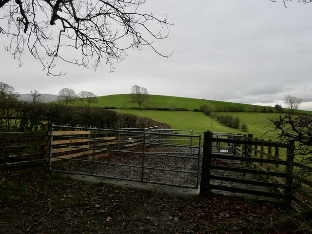
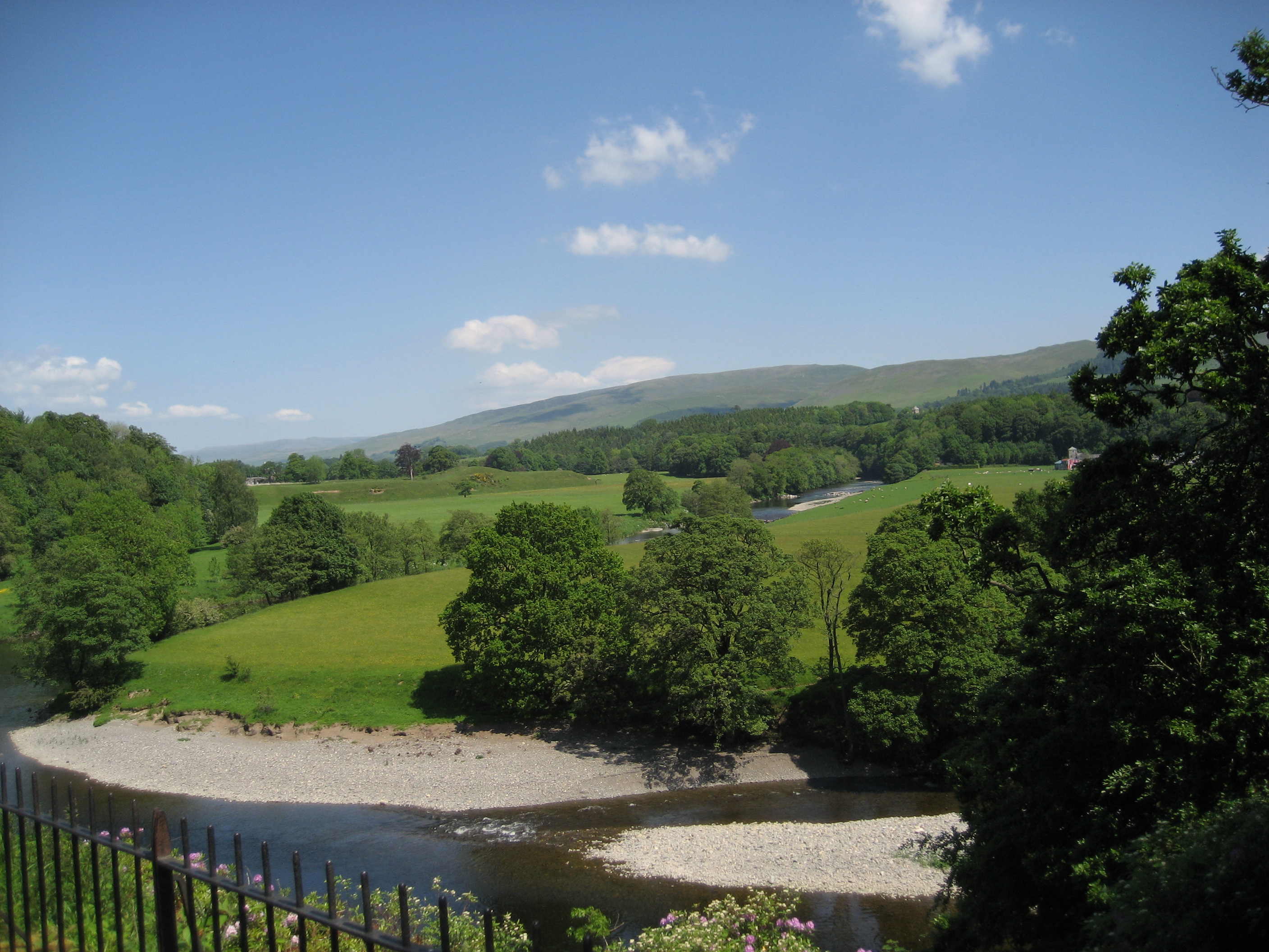
High House Wood is a picturesque forest located in Lancashire, England. Covering an area of approximately 200 acres, this enchanting woodland is known for its diverse range of flora and fauna, making it a haven for nature lovers and wildlife enthusiasts alike.

The wood is predominantly composed of deciduous trees, such as oak, beech, and birch, which create a stunning canopy of greenery throughout the year. These towering trees provide ample shade and create a tranquil atmosphere, perfect for a leisurely stroll or a peaceful picnic.

High House Wood is home to a wide variety of wildlife, including birds, mammals, and insects. Birdwatchers can spot species such as woodpeckers, tits, and finches, while lucky visitors may even catch a glimpse of the elusive red squirrel, a rare sight in many parts of the country.

The forest boasts several well-maintained footpaths and trails, allowing visitors to explore the woodland at their own pace. These paths wind through the trees, offering stunning views of the surrounding countryside and providing ample opportunities for photography and nature observation.

High House Wood is also a popular destination for families, as it offers numerous recreational facilities. The forest has a dedicated picnic area with benches and tables, as well as a children's play area, complete with swings and climbing frames.

Overall, High House Wood is a true gem in the heart of Lancashire, providing a peaceful retreat for visitors to connect with nature and enjoy the beauty of the British countryside.

If you have any feedback on the listing, please let us know in the comments section below.

High House Wood Images

Images are sourced within 2km of 54.188731/-2.5923709 or Grid Reference SD6177. Thanks to Geograph Open Source API. All images are credited.

Sheep pens, Hosticle Lane
Hosticle Lane Passing Hagg Wood.
Hosticle Lane
Passing Hagg Wood.
Hosticle Lane
Hosticle Lane
Field off Biggins Lane
Biggins Lane
Biggins Lane
War Memorial at St Michael's Church Whittingtom The memorial is in the form of a stone cross on a two-step octagonal base. It is inscribed:
FOR GOD KING AND COUNTRY
1914-1918

Six names are listed for World War I and one name is listed for the Second World War.
War Memorial at St Michael's Church Whittingtom
The memorial is in the form of a stone cross on a two-step octagonal base. It is inscribed: FOR GOD KING AND COUNTRY 1914-1918 Six names are listed for World War I and one name is listed for the Second World War.
The Church of St Michael the Archangel, Whittington The sandstone rubble church dates from the early 16th century with extensive restoration to the nave and chancel in 1875. It is a Grade II* listed building (List Entry: 1071615 <span class="nowrap"><a title="https://historicengland.org.uk/listing/the-list/list-entry/1071615" rel="nofollow ugc noopener" href="https://historicengland.org.uk/listing/the-list/list-entry/1071615">Link</a><img style="margin-left:2px;" alt="External link" title="External link - shift click to open in new window" src="https://s1.geograph.org.uk/img/external.png" width="10" height="10"/></span> Historic England).  The church stands within the bailey of a former motte and bailey castle <span class="nowrap"><a title="https://historicengland.org.uk/listing/the-list/list-entry/1010796" rel="nofollow ugc noopener" href="https://historicengland.org.uk/listing/the-list/list-entry/1010796">Link</a><img style="margin-left:2px;" alt="External link" title="External link - shift click to open in new window" src="https://s1.geograph.org.uk/img/external.png" width="10" height="10"/></span>. It is thought that there has been a church on this site since 1200.
The Church of St Michael the Archangel, Whittington
The sandstone rubble church dates from the early 16th century with extensive restoration to the nave and chancel in 1875. It is a Grade II* listed building (List Entry: 1071615 LinkExternal link Historic England). The church stands within the bailey of a former motte and bailey castle LinkExternal link. It is thought that there has been a church on this site since 1200.
St Michael's Church, Whittington The Church of St Michael the Archangel is an Anglican parish church in the deanery of Tunstall. It is recorded in the National Heritage List for England as a designated Grade II* listed building (List Entry: 1071615 <span class="nowrap"><a title="https://historicengland.org.uk/listing/the-list/list-entry/1071615" rel="nofollow ugc noopener" href="https://historicengland.org.uk/listing/the-list/list-entry/1071615">Link</a><img style="margin-left:2px;" alt="External link" title="External link - shift click to open in new window" src="https://s1.geograph.org.uk/img/external.png" width="10" height="10"/></span> Historic England). The oldest part of the present church is the tower, which dates from the early 16th century. The nave and chancel were extensively restored in 1875.

The church stands within the bailey of a former motte and bailey castle <span class="nowrap"><a title="https://historicengland.org.uk/listing/the-list/list-entry/1010796" rel="nofollow ugc noopener" href="https://historicengland.org.uk/listing/the-list/list-entry/1010796">Link</a><img style="margin-left:2px;" alt="External link" title="External link - shift click to open in new window" src="https://s1.geograph.org.uk/img/external.png" width="10" height="10"/></span> and it is thought that there has been a church on this site since 1200.
St Michael's Church, Whittington
The Church of St Michael the Archangel is an Anglican parish church in the deanery of Tunstall. It is recorded in the National Heritage List for England as a designated Grade II* listed building (List Entry: 1071615 LinkExternal link Historic England). The oldest part of the present church is the tower, which dates from the early 16th century. The nave and chancel were extensively restored in 1875. The church stands within the bailey of a former motte and bailey castle LinkExternal link and it is thought that there has been a church on this site since 1200.
Whittington, The Church of St Michael the Archangel The Church of St Michael the Archangel is an Anglican parish church in the deanery of Tunstall. It is recorded in the National Heritage List for England as a designated Grade II* listed building (List Entry: 1071615 <span class="nowrap"><a title="https://historicengland.org.uk/listing/the-list/list-entry/1071615" rel="nofollow ugc noopener" href="https://historicengland.org.uk/listing/the-list/list-entry/1071615">Link</a><img style="margin-left:2px;" alt="External link" title="External link - shift click to open in new window" src="https://s1.geograph.org.uk/img/external.png" width="10" height="10"/></span> Historic England). The oldest part of the present church is the tower, which dates from the early 16th century. The nave and chancel were extensively restored in 1875.

The church stands within the bailey of a former motte and bailey castle <span class="nowrap"><a title="https://historicengland.org.uk/listing/the-list/list-entry/1010796" rel="nofollow ugc noopener" href="https://historicengland.org.uk/listing/the-list/list-entry/1010796">Link</a><img style="margin-left:2px;" alt="External link" title="External link - shift click to open in new window" src="https://s1.geograph.org.uk/img/external.png" width="10" height="10"/></span> and it is thought that there has been a church on this site since 1200.
Whittington, The Church of St Michael the Archangel
The Church of St Michael the Archangel is an Anglican parish church in the deanery of Tunstall. It is recorded in the National Heritage List for England as a designated Grade II* listed building (List Entry: 1071615 LinkExternal link Historic England). The oldest part of the present church is the tower, which dates from the early 16th century. The nave and chancel were extensively restored in 1875. The church stands within the bailey of a former motte and bailey castle LinkExternal link and it is thought that there has been a church on this site since 1200.
High Biggins Manor A modest country residence, recently rebuilt on the site of Biggins Home Farm. Also see <a href="https://www.geograph.org.uk/photo/4914896">SD5978 : High Biggins Manor</a> & <a href="https://www.geograph.org.uk/photo/5413193">SD5977 : Biggins Home Farm</a>.
High Biggins Manor
A modest country residence, recently rebuilt on the site of Biggins Home Farm. Also see SD5978 : High Biggins Manor & SD5977 : Biggins Home Farm.
The Devil's Bridge over the River Lune
Former railway bridge, Well Lane The railway was the LMS route one between the 'Little North Western' line at Clapham and their main line to Scotland at Lowgill, via Ingleton. It last saw regular trains in 1954 and the track was lifted in 1967. See <a href="https://www.geograph.org.uk/photo/390005">SD6278 : Disused railway bridge in High Casterton</a> for the other side.
Former railway bridge, Well Lane
The railway was the LMS route one between the 'Little North Western' line at Clapham and their main line to Scotland at Lowgill, via Ingleton. It last saw regular trains in 1954 and the track was lifted in 1967. See SD6278 : Disused railway bridge in High Casterton for the other side.
River Lune, Stanley Bridge at Kirkby Lonsdale The bridge carrying the A65 over the River Lune at Kirkby Lonsdale was commissioned by Westmorland County Council and was opened by the Mayor of Kirkby Lonsdale, Oliver Stanley, on 3rd December 1932 to replace the mediæval bridge which is approximately 100 metres further upstream. The bridge is named for the mayor.
River Lune, Stanley Bridge at Kirkby Lonsdale
The bridge carrying the A65 over the River Lune at Kirkby Lonsdale was commissioned by Westmorland County Council and was opened by the Mayor of Kirkby Lonsdale, Oliver Stanley, on 3rd December 1932 to replace the mediæval bridge which is approximately 100 metres further upstream. The bridge is named for the mayor.
River Lune at Kirkby Lonsdale Looking upstream from Devil's Bridge
River Lune at Kirkby Lonsdale
Looking upstream from Devil's Bridge
Biggins Lane, High Biggins
Church Street, Whittington (Lancs)
B6254, Whittington
B6254, Whittington
Field, Whittington Beside the north end of Coneygarth Lane.
Field, Whittington
Beside the north end of Coneygarth Lane.
Show me another place!

High House Wood is located at Grid Ref: SD6177 (Lat: 54.188731, Lng: -2.5923709)

Administrative County: Lancashire

District: Lancaster

Police Authority: Lancashire

What 3 Words

///intend.tubes.arranges. Near Kirkby Lonsdale, Cumbria

Related Wikis

Over Burrow Roman Fort

Over Burrow Roman Fort is the modern name given to a former Roman fort at Over Burrow (or Burrow-in-Londsale), Lancashire in North West England. Today...
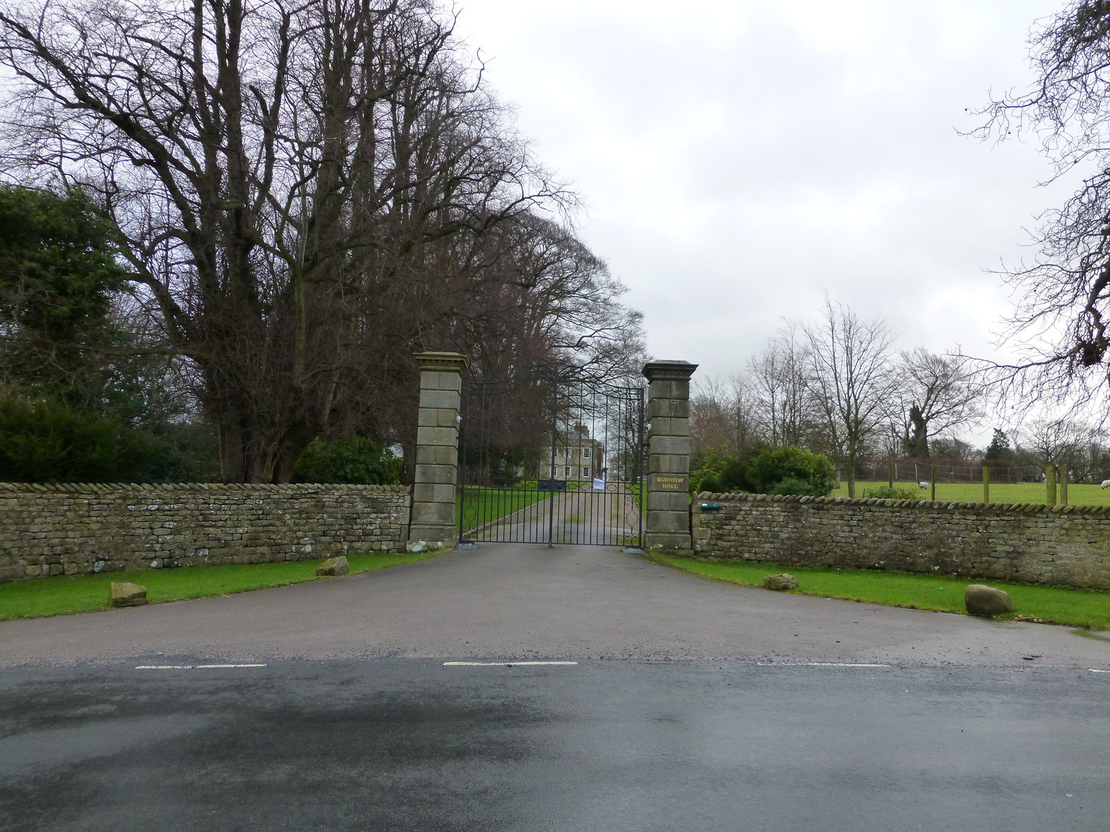
Burrow Hall

Burrow Hall is a large 18th-century country house in Burrow-with-Burrow, Lancashire, England, which lies in the Lune Valley on the A683 some 2 miles (3...

Kirkby Lonsdale

Kirkby Lonsdale () is a town and civil parish in the Westmorland and Furness district of Cumbria, England, on the River Lune. Historically in Westmorland...

Kirkby Lonsdale railway station

Kirkby Lonsdale railway station was located in Lancashire, England, on the Ingleton Branch Line, 2 miles (3 km) from the town of Kirkby Lonsdale in Westmorland...

Burrow-with-Burrow

Burrow-with-Burrow is a civil parish in the English county of Lancashire. The parish of Burrow-with-Burrow had a population of 191 recorded in the 2001...

Whittington, Lancashire

Whittington is a small village and civil parish in Lancashire, England, forming part of a cluster of sites along the Lune valley, each with evidence of...

Queen Elizabeth School, Kirkby Lonsdale

Queen Elizabeth School, also abbreviated to as QES, is a coeducational, comprehensive secondary school and sixth form with academy status. It is located...

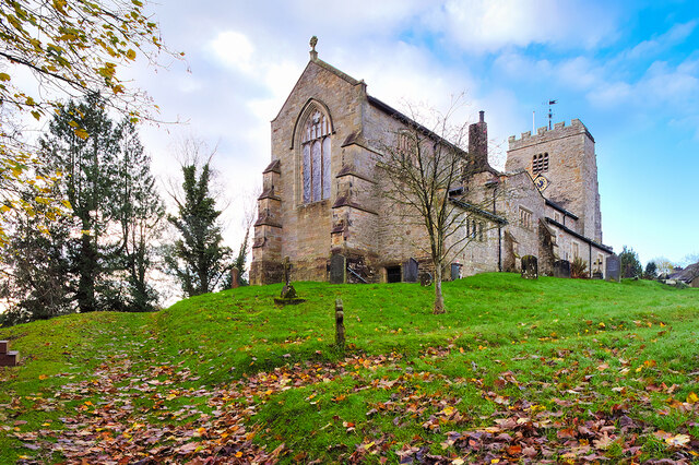
St Mary's Church, Kirkby Lonsdale

St Mary's Church is in the town of Kirkby Lonsdale, Cumbria, England. It is an active Anglican parish church in the deanery of Kendal, the archdeaconry...

Nearby Amenities

Located within 500m of 54.188731,-2.5923709
Power: pole
Lat/Long: 54.1904981/-2.5991087
Power: pole
Lat/Long: 54.1905109/-2.5973111
Power: pole
Lat/Long: 54.1905036/-2.5955104
Power: pole
Lat/Long: 54.1909162/-2.5929701
Material: wood
Power: pole
Lat/Long: 54.1902333/-2.590926
Material: wood
Power: pole
Lat/Long: 54.1900599/-2.5902738
Material: wood
Power: pole
Lat/Long: 54.1894537/-2.5897651
Material: wood
Power: pole
Lat/Long: 54.1888949/-2.589194
Material: wood
Power: pole
Lat/Long: 54.1882613/-2.5885948
Power: pole
Lat/Long: 54.1874378/-2.5877766
Power: pole
Lat/Long: 54.1866932/-2.5870266
Power: pole
Lat/Long: 54.1860205/-2.5864241
The data included in this document is from www.openstreetmap.org. The data is made available under ODbL.

Have you been to High House Wood?

Leave your review of High House Wood below (or comments, questions and feedback).