Ebbing Stane

Island in Angus

Scotland

Ebbing Stane

Cliffs in Carlingheugh Bay The cleft in the cliff is a fault which has been exploited by the sea to form the Dark Cave, one of two caves that extend right through the headland to the next bay. The other one, the Light Cave, is further to the right. When you enter the Light cave, you can see the light at the other end, but the Dark Cave is, as its name suggests, completely dark. Bring a torch if you're going to explore it, and mind your head inside. The slightly wavy almost vertical feature next to the cave entrance is a vein of baryte (Barium sulphate, BaSO4, also known as barite and barytes). This has leached out of the sandstone and there are several such veins in the vicinity. Baryte is very dense (about 4½ tonnes per cubic metre, compared with sandstone which has a density of about 2¼ tonnes per cubic metre) and is used to make drilling mud to seal oil wells, and it is the most important ore of barium, which has many uses in medicine, engineering and other fields. See <span class="nowrap"><a title="https://en.wikipedia.org/wiki/Baryte" rel="nofollow ugc noopener" href="https://en.wikipedia.org/wiki/Baryte">Link</a><img style="margin-left:2px;" alt="External link" title="External link - shift click to open in new window" src="https://s1.geograph.org.uk/img/external.png" width="10" height="10"/></span>.
Cliffs in Carlingheugh Bay Credit: Anne Burgess

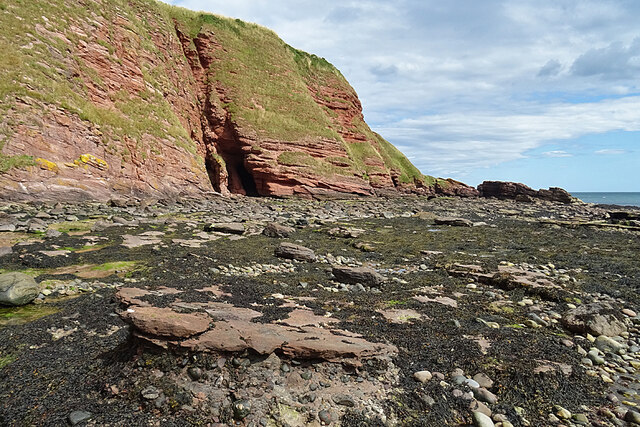
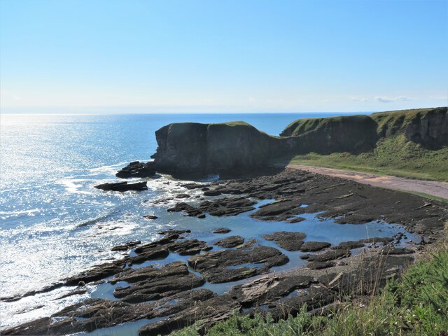
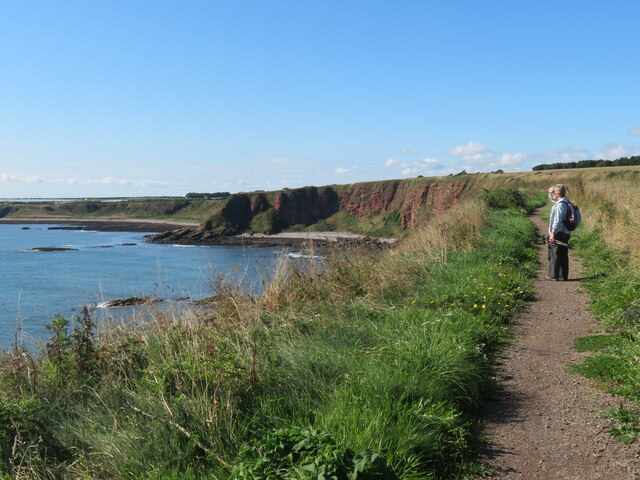
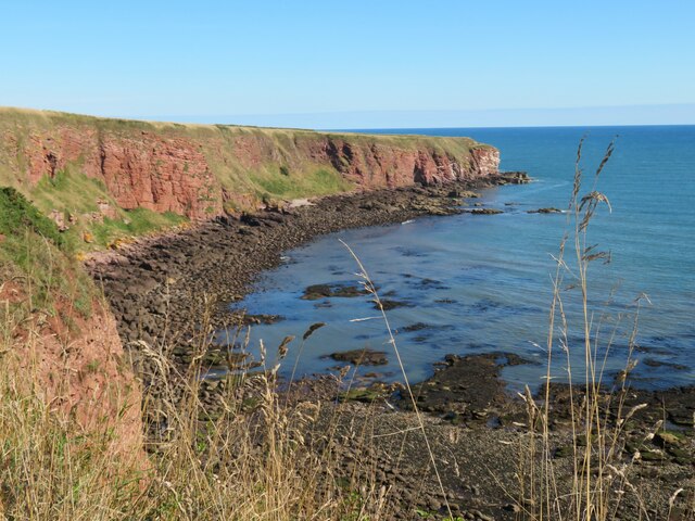
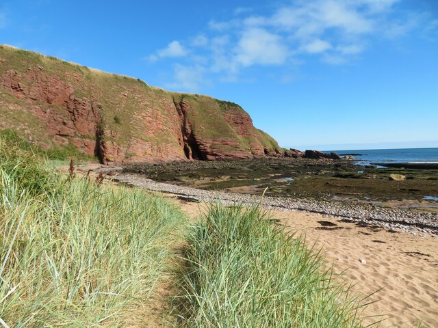
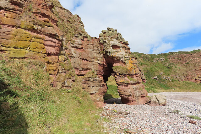
Ebbing Stane is a small island located off the coast of Angus, Scotland. It is situated in the North Sea, approximately 2 miles from the mainland. The island is known for its unique geological formation, which gives it its name. The term "stane" is Scots for "stone," and "ebbing" refers to the island's exposure during low tide.

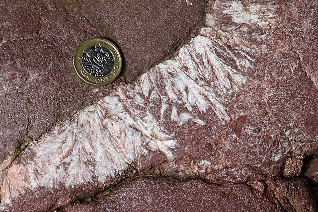
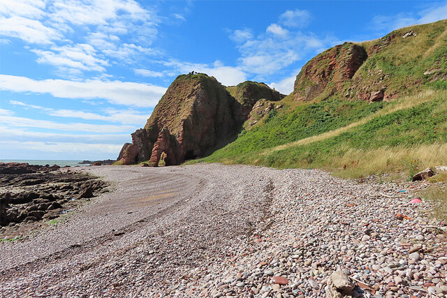
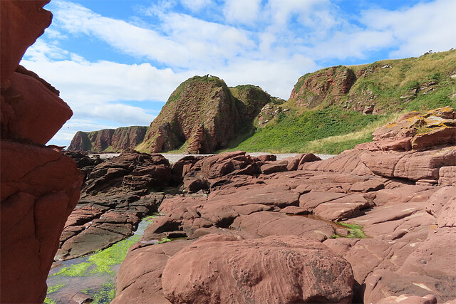
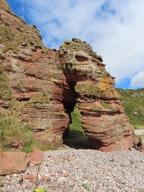
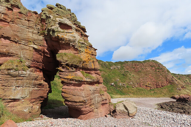
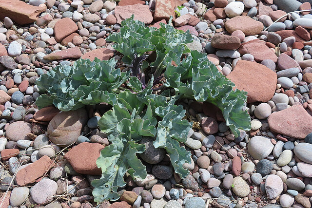
Ebbing Stane is a flat, rocky island that measures around 300 meters in length and 200 meters in width. It is predominantly composed of sandstone and shale, with scattered patches of grass and low vegetation. The island is uninhabited and lacks any permanent structures or facilities.

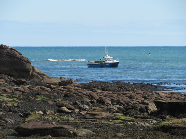
During high tide, Ebbing Stane is almost completely submerged, with only a small rocky outcrop visible above the water. However, as the tide recedes, it gradually emerges, revealing its unique features. At low tide, visitors can access the island by foot or by boat, as the waters surrounding it become shallow enough.

The island is a popular destination for nature enthusiasts and photographers due to its picturesque and isolated setting. It offers stunning views of the surrounding coastline and is home to a variety of seabirds and marine life. Visitors should be cautious when exploring the island, as the terrain can be slippery and treacherous, especially during wet weather.

Overall, Ebbing Stane is a small, captivating island that offers a glimpse into the natural beauty of the Angus coastline.

If you have any feedback on the listing, please let us know in the comments section below.

Ebbing Stane Images

Images are sourced within 2km of 56.588685/-2.5149751 or Grid Reference NO6844. Thanks to Geograph Open Source API. All images are credited.

Cliffs in Carlingheugh Bay The cleft in the cliff is a fault which has been exploited by the sea to form the Dark Cave, one of two caves that extend right through the headland to the next bay. The other one, the Light Cave, is further to the right. When you enter the Light cave, you can see the light at the other end, but the Dark Cave is, as its name suggests, completely dark. Bring a torch if you're going to explore it, and mind your head inside. The slightly wavy almost vertical feature next to the cave entrance is a vein of baryte (Barium sulphate, BaSO4, also known as barite and barytes). This has leached out of the sandstone and there are several such veins in the vicinity. Baryte is very dense (about 4½ tonnes per cubic metre, compared with sandstone which has a density of about 2¼ tonnes per cubic metre) and is used to make drilling mud to seal oil wells, and it is the most important ore of barium, which has many uses in medicine, engineering and other fields. See <span class="nowrap"><a title="https://en.wikipedia.org/wiki/Baryte" rel="nofollow ugc noopener" href="https://en.wikipedia.org/wiki/Baryte">Link</a><img style="margin-left:2px;" alt="External link" title="External link - shift click to open in new window" src="https://s1.geograph.org.uk/img/external.png" width="10" height="10"/></span>.
Cliffs in Carlingheugh Bay
The cleft in the cliff is a fault which has been exploited by the sea to form the Dark Cave, one of two caves that extend right through the headland to the next bay. The other one, the Light Cave, is further to the right. When you enter the Light cave, you can see the light at the other end, but the Dark Cave is, as its name suggests, completely dark. Bring a torch if you're going to explore it, and mind your head inside. The slightly wavy almost vertical feature next to the cave entrance is a vein of baryte (Barium sulphate, BaSO4, also known as barite and barytes). This has leached out of the sandstone and there are several such veins in the vicinity. Baryte is very dense (about 4½ tonnes per cubic metre, compared with sandstone which has a density of about 2¼ tonnes per cubic metre) and is used to make drilling mud to seal oil wells, and it is the most important ore of barium, which has many uses in medicine, engineering and other fields. See LinkExternal link.
Barite Crystals The white dendritic shapes are crystals of Barium sulphate, BaSO4, also known as barite and baryte, which have leached out from igneous fluids permeating the sandstone. Baryte is very dense (about 4½ tonnes per cubic metre, compared with sandstone which has a density of about 2¼ tonnes per cubic metre) and is used to make drilling mud to seal oil wells, and it is the most important ore of barium, which has many uses in medicine, engineering and other fields. See <span class="nowrap"><a title="https://en.wikipedia.org/wiki/Baryte" rel="nofollow ugc noopener" href="https://en.wikipedia.org/wiki/Baryte">Link</a><img style="margin-left:2px;" alt="External link" title="External link - shift click to open in new window" src="https://s1.geograph.org.uk/img/external.png" width="10" height="10"/></span>.
Barite Crystals
The white dendritic shapes are crystals of Barium sulphate, BaSO4, also known as barite and baryte, which have leached out from igneous fluids permeating the sandstone. Baryte is very dense (about 4½ tonnes per cubic metre, compared with sandstone which has a density of about 2¼ tonnes per cubic metre) and is used to make drilling mud to seal oil wells, and it is the most important ore of barium, which has many uses in medicine, engineering and other fields. See LinkExternal link.
But n Ben restaurant, Auchmithie Restaurant in a traditional cottage style building at the start of the old part of the clifftop village.
But n Ben restaurant, Auchmithie
Restaurant in a traditional cottage style building at the start of the old part of the clifftop village.
St Peter's Church, Auchmithie Scottish Episcopal Church situated at the western end of the village.
St Peter's Church, Auchmithie
Scottish Episcopal Church situated at the western end of the village.
Across Castlesea Bay Looking south across the bay to the promontory of Lud Castle, which is an iron age fort.
Across Castlesea Bay
Looking south across the bay to the promontory of Lud Castle, which is an iron age fort.
Harvested field south of Auchmithie A view from the coast path looking inland across a recently cropped field towards Auchmithie church.
Harvested field south of Auchmithie
A view from the coast path looking inland across a recently cropped field towards Auchmithie church.
Walking the coast path towards Carlingheugh Bay Not sure if this is one bay or two as the small rocky promontory centre left appears to form a sort of break.
Walking the coast path towards Carlingheugh Bay
Not sure if this is one bay or two as the small rocky promontory centre left appears to form a sort of break.
Devonian sandstone meets the North Sea The red cliffs of Angus are made from Devonian period sandstone - a sedimentary rock.
Devonian sandstone meets the North Sea
The red cliffs of Angus are made from Devonian period sandstone - a sedimentary rock.
Beach at the northern end of Carlingheugh Bay An ideal lunch spot on a walk from Auchmithie to Arbroath. Sand gives way to pebbles and then a wave cut platform festooned with seaweed. The Dark Cave is prominent in the centre of the picture, formed on a minor fault line.
Beach at the northern end of Carlingheugh Bay
An ideal lunch spot on a walk from Auchmithie to Arbroath. Sand gives way to pebbles and then a wave cut platform festooned with seaweed. The Dark Cave is prominent in the centre of the picture, formed on a minor fault line.
Lobster fishing off Carlingheugh Bay Small fishing boat close to shore checking out lobster pots.
Lobster fishing off Carlingheugh Bay
Small fishing boat close to shore checking out lobster pots.
Narrow-leaved Everlasting Pea (Lathyrus sylvestris) There's quite a lot of this in the East Den, though overall it is not common in northern Scotland.
Narrow-leaved Everlasting Pea (Lathyrus sylvestris)
There's quite a lot of this in the East Den, though overall it is not common in northern Scotland.
Narrow-leaved Everlasting Pea (Lathyrus sylvestris) These are the seed pods of <a href="https://www.geograph.org.uk/photo/7247694">NO6945 : Narrow-leaved Everlasting Pea (Lathyrus sylvestris)</a>.
Narrow-leaved Everlasting Pea (Lathyrus sylvestris)
Beach north of Rumness Rumness itself is more or less hidden behind the headland, but according to the old Ordnance Survey maps none of the other rock features here has a name.
Beach north of Rumness
Rumness itself is more or less hidden behind the headland, but according to the old Ordnance Survey maps none of the other rock features here has a name.
Old Red Sandstone The rocks in the foreground are sandstones of Devonian age, laid down in arid conditions some 420 million years ago when what is now Scotland was at the latitude of the present-day Sahara Desert.
Old Red Sandstone
The rocks in the foreground are sandstones of Devonian age, laid down in arid conditions some 420 million years ago when what is now Scotland was at the latitude of the present-day Sahara Desert.
Natural Arch The sea has carved a hole through a rocky headland to create a natural arch in the Old Red Sandstone.
Natural Arch
The sea has carved a hole through a rocky headland to create a natural arch in the Old Red Sandstone.
Natural Arch and Pebble Beach The sea has carved a hole through a rocky headland to create a natural arch in the Old Red Sandstone.
Natural Arch and Pebble Beach
The sea has carved a hole through a rocky headland to create a natural arch in the Old Red Sandstone.
Natural Arch and Pebble Beach The sea has carved a hole through a rocky headland to create a natural arch in the Old Red Sandstone.
Natural Arch and Pebble Beach
The sea has carved a hole through a rocky headland to create a natural arch in the Old Red Sandstone.
Sea Kale (Crambe maritima) This is quite common on coasts further south, but more unusual further north. We noted only two plants of it on this particular beach.
Sea Kale (Crambe maritima)
This is quite common on coasts further south, but more unusual further north. We noted only two plants of it on this particular beach.
Show me another place!

Ebbing Stane is located at Grid Ref: NO6844 (Lat: 56.588685, Lng: -2.5149751)

Unitary Authority: Angus

Police Authority: Tayside

What 3 Words

///wink.thousands.skill. Near Arbroath, Angus

Related Wikis

Auchmithie

Auchmithie is a small fishing village in Angus, Scotland, three miles north east of the town of Arbroath. It sits atop a cliff of red sandstone conglomerate...
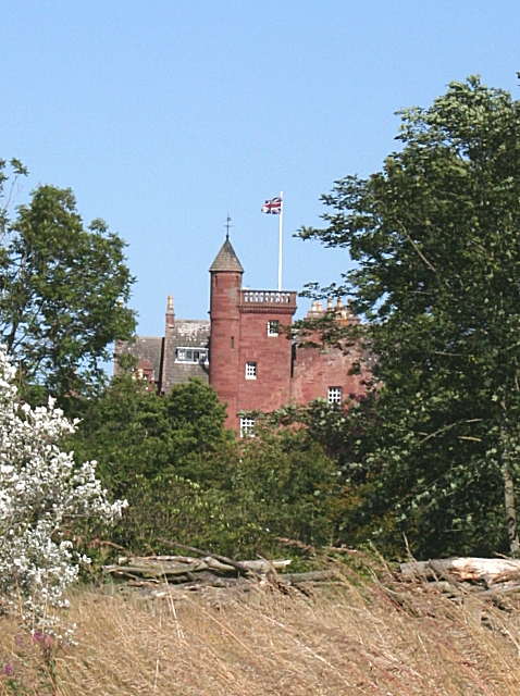
Ethie Castle

Ethie Castle is a 15,091 square feet (1,402.0 m2) 14th-century castle, situated around 3 miles north of the fishing town of Arbroath in Angus, Scotland...

Marywell

Marywell is a village in Angus, Scotland, that is north of Arbroath, in the parish of St Vigeans. == References == == Sources == Marywell in the Gazetteer...
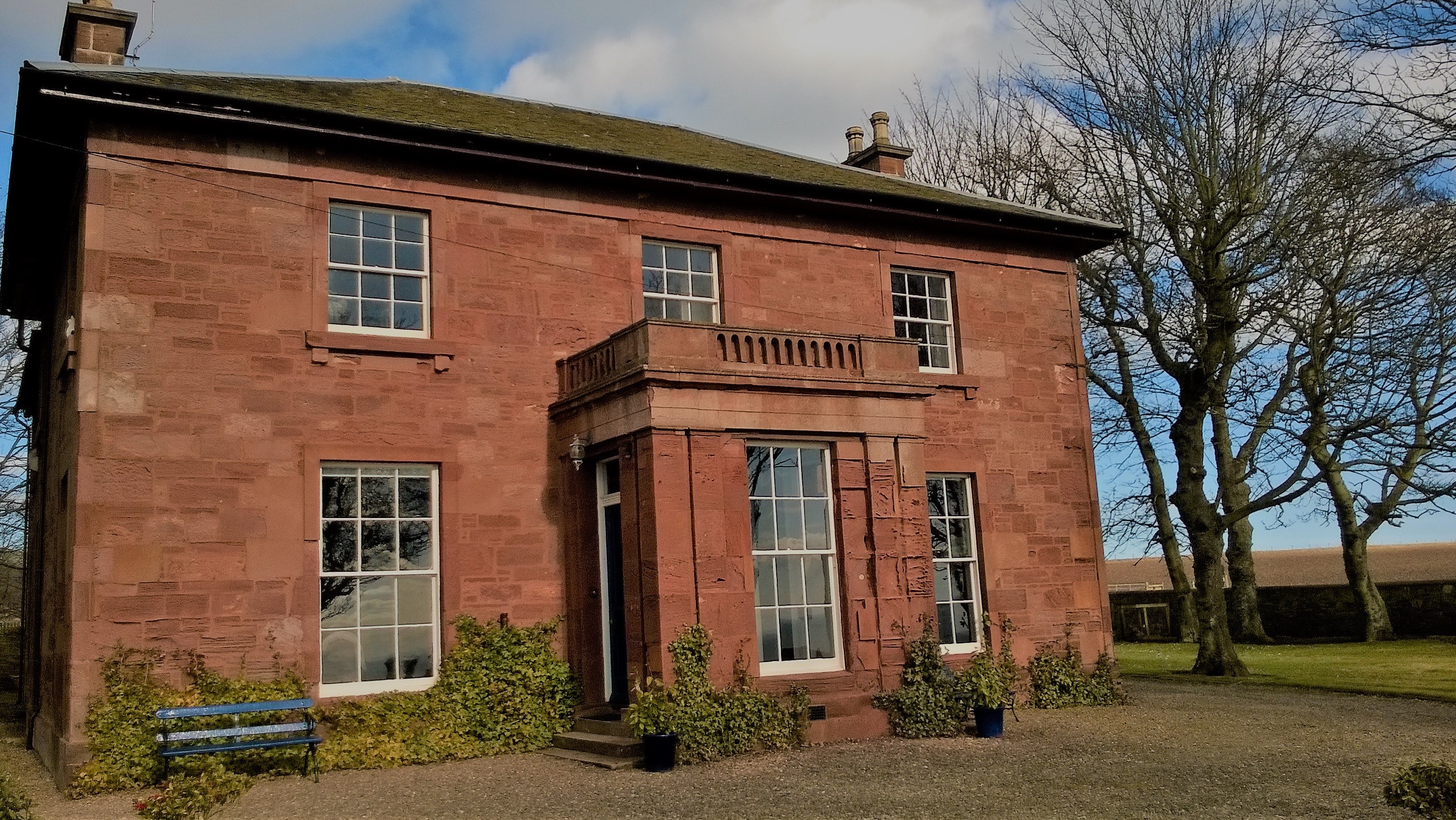
West Seaton House

West Seaton House is a listed building of late Regency design, situated approximately one mile (1.6 km) to the east of Arbroath in the parish of St. Vigeans...

Cauldcots railway station

Cauldcots railway station served the hamlet of Cauldcots, Angus, Scotland, from 1883 to 1930 on the North British, Arbroath and Montrose Railway. ��2...

St Vigeans Sculptured Stones Museum

St Vigeans Sculptured Stones Museum, located in the Angus village of St Vigeans, houses an outstanding collection of Pictish carved stones. St Vigeans...

St Vigeans Church

St Vigeans Church is a Church of Scotland parish church, serving the parish of the ancient village of St Vigeans on the outskirts of Arbroath, Angus, Scotland...

Church of St Mary the Virgin, Arbroath

The Church of St Mary the Virgin is a Scottish Episcopal Church, in Arbroath, Angus, Scotland. It is part of the Diocese of Brechin. == Church building... ==

Nearby Amenities

Located within 500m of 56.588685,-2.5149751
Source: PGS
Lat/Long: 56.5914981/-2.5182317
Created By: almien_coastlines
Source: PGS
Lat/Long: 56.591669/-2.518216
Source: PGS
Lat/Long: 56.5918541/-2.5180842
Created By: almien_coastlines
Source: PGS
Lat/Long: 56.592052/-2.517978
Created By: almien_coastlines
Source: PGS
Lat/Long: 56.59218/-2.517746
Created By: almien_coastlines
Source: PGS
Lat/Long: 56.592306/-2.517511
Created By: almien_coastlines
Source: PGS
Lat/Long: 56.592434/-2.517278
Created By: almien_coastlines
Source: PGS
Lat/Long: 56.585276/-2.520153
Created By: almien_coastlines
Source: PGS
Lat/Long: 56.5854331/-2.5201432
Source: PGS
Lat/Long: 56.5890622/-2.5188089
Source: PGS
Lat/Long: 56.5889601/-2.5189984
Created By: almien_coastlines
Source: PGS
Lat/Long: 56.591161/-2.519151
Created By: almien_coastlines
Source: PGS
Lat/Long: 56.591288/-2.518916
Old Phone: +44 1241 872565
Removed Amenity: telephone
Lat/Long: 56.5898418/-2.5216121
Post Box
Collection Times: Mo-Fr 12:00; Sa 12:15
Operator: Royal Mail
Operator Wikidata: Q638098
Post Box Type: wall
Postal Code: DD11 5SQ
Ref: DD11 327
Royal Cypher: GR
Royal Cypher Wikidata: Q33102273
Lat/Long: 56.5898449/-2.5216285
Bench
Lat/Long: 56.5894867/-2.5207529
Fountain
Lat/Long: 56.589665/-2.522373
Coastguard Station Cottages
Alt Name: Old Coastguard Station
Alt Name 1: Coastguard Cottages
Place: hamlet
Lat/Long: 56.5868208/-2.519621
Addr City: Auchmithie
Addr Housename: The Anchorage
Addr Street: Auchmithie Village
Lat/Long: 56.5902985/-2.5211706
Addr City: Auchmithie
Addr Housenumber: 5
Addr Street: Auchmithie Village
Lat/Long: 56.589198/-2.5230315
Addr City: Auchmithie
Addr Housenumber: 6
Addr Street: Auchmithie Village
Lat/Long: 56.5892627/-2.5229155
Addr City: Auchmithie
Addr Housenumber: 8
Addr Street: Auchmithie Village
Lat/Long: 56.5893868/-2.5226897
Addr City: Auchmithie
Addr Housenumber: 2
Addr Street: Fountain Square
Lat/Long: 56.5896921/-2.5225161
Addr City: Auchmithie
Addr Housenumber: 3
Addr Street: Fountain Square
Lat/Long: 56.5897384/-2.5224246
Addr City: Auchmithie
Addr Housenumber: 4
Addr Street: Fountain Square
Lat/Long: 56.5897665/-2.5223453
Addr City: Auchmithie
Addr Housenumber: 5
Addr Street: Fountain Square
Lat/Long: 56.5897207/-2.5222628
Addr City: Auchmithie
Addr Housenumber: 1
Addr Street: Fountain Square
Lat/Long: 56.5895985/-2.5224662
Meg's Craig
Natural: cliff
Lat/Long: 56.5864876/-2.5184001
Grit Bin
Lat/Long: 56.5898329/-2.5216779
Waste Basket
Lat/Long: 56.5898235/-2.5216948
Street Lamp
Lat/Long: 56.5892031/-2.5228589
Street Lamp
Lat/Long: 56.5893643/-2.5225605
Street Lamp
Lat/Long: 56.5895315/-2.522232
Street Lamp
Lat/Long: 56.5896814/-2.5219731
Street Lamp
Lat/Long: 56.5898288/-2.5216834
Street Lamp
Lat/Long: 56.5899602/-2.5216063
Street Lamp
Lat/Long: 56.5898934/-2.5213193
Street Lamp
Lat/Long: 56.5900034/-2.5213488
Street Lamp
Lat/Long: 56.5901984/-2.5212697
Street Lamp
Lat/Long: 56.5903305/-2.5211088
Street Lamp
Lat/Long: 56.5896859/-2.5211439
Addr City: Auchmithie
Addr Housenumber: 61
Addr Street: Auchmithie Village
Lat/Long: 56.5894317/-2.521461
Addr City: Auchmithie
Addr Housenumber: 54
Addr Street: Auchmithie Village
Lat/Long: 56.5894571/-2.5220849
Addr City: Auchmithie
Addr Housenumber: 56
Addr Street: Auchmithie Village
Lat/Long: 56.5893498/-2.5220236
Addr City: Auchmithie
Addr Housenumber: 66
Addr Street: Auchmithie Village
Lat/Long: 56.5893322/-2.5226115
Addr City: Auchmithie
Addr Housenumber: 7
Addr Street: Auchmithie Village
Lat/Long: 56.5893244/-2.522804
Addr City: Auchmithie
Addr Housenumber: 45
Addr Street: Auchmithie Village
Lat/Long: 56.5895889/-2.5221406
Addr City: Auchmithie
Addr Housenumber: 44
Addr Street: Auchmithie Village
Lat/Long: 56.58965/-2.522022
Addr City: Auchmithie
Addr Housenumber: 43
Addr Street: Auchmithie Village
Lat/Long: 56.5897072/-2.5219128
Addr City: Auchmithie
Addr Housenumber: 42
Addr Street: Auchmithie Village
Lat/Long: 56.5897595/-2.521808
Addr City: Auchmithie
Addr Housenumber: 47
Addr Street: Auchmithie Village
Lat/Long: 56.5895664/-2.5218743
Addr City: Auchmithie
Addr Housenumber: 61
Addr Street: Auchmithie Village
Lat/Long: 56.5894484/-2.5214719
Addr City: Auchmithie
Addr Housenumber: 15
Addr Street: Auchmithie Village
Lat/Long: 56.5897947/-2.5219657
Addr City: Auchmithie
Addr Housenumber: 16
Addr Street: Auchmithie Village
Lat/Long: 56.5898497/-2.5218423
Addr City: Auchmithie
Addr Housenumber: 17
Addr Street: Auchmithie Village
Lat/Long: 56.5898977/-2.5217551
Addr City: Auchmithie
Addr Housenumber: 18
Addr Street: Auchmithie Village
Lat/Long: 56.5899436/-2.5216873
Addr City: Auchmithie
Addr Housenumber: 19
Addr Street: Auchmithie Village
Lat/Long: 56.5899952/-2.5215738
Addr City: Auchmithie
Addr Housenumber: 20
Addr Street: Auchmithie Village
Lat/Long: 56.5900477/-2.5214554
Addr City: Auchmithie
Addr Housenumber: 21
Addr Street: Auchmithie Village
Lat/Long: 56.5901838/-2.521358
Addr City: Auchmithie
Addr Housenumber: 24
Addr Street: Auchmithie Village
Lat/Long: 56.5903734/-2.5210509
Addr City: Auchmithie
Addr Housenumber: 27
Addr Street: Auchmithie Village
Lat/Long: 56.5901678/-2.5210769
Addr City: Auchmithie
Addr Housenumber: 28
Addr Street: Auchmithie Village
Lat/Long: 56.5900818/-2.5212063
Addr City: Auchmithie
Addr Housenumber: 40
Addr Street: Auchmithie Village
Lat/Long: 56.5898431/-2.5211339
Addr City: Auchmithie
Addr Housenumber: 65
Addr Street: Auchmithie Village
Lat/Long: 56.5893853/-2.5225047
Addr City: Auchmithie
Addr Housenumber: 31
Addr Street: Auchmithie Village
Lat/Long: 56.5898962/-2.5211427
Addr City: Auchmithie
Addr Housenumber: 39
Addr Street: Auchmithie Village
Lat/Long: 56.5898919/-2.5210271
Addr City: Auchmithie
Addr Housenumber: 49
Addr Street: Auchmithie Village
Lat/Long: 56.5896013/-2.5215828
Addr City: Auchmithie
Addr Housenumber: 50
Addr Street: Auchmithie Village
Lat/Long: 56.5896493/-2.5214651
Auchmithie Bay
Natural: bay
Lat/Long: 56.5905334/-2.5167617
Natural: cave_entrance
Lat/Long: 56.59175/-2.5186906
Power: pole
Lat/Long: 56.5900094/-2.5224104
Power: pole
Lat/Long: 56.5904566/-2.5214229
Power: pole
Lat/Long: 56.5901787/-2.52196
Power: pole
Lat/Long: 56.5897805/-2.5227807
Power: pole
Lat/Long: 56.588662/-2.5225945
Power: pole
Lat/Long: 56.588278/-2.5217673
Power: pole
Lat/Long: 56.5879024/-2.5209249
Power: pole
Lat/Long: 56.5875256/-2.5200847
Power: pole
Lat/Long: 56.5871571/-2.5192899
Power: pole
Lat/Long: 56.5870414/-2.5197382
The data included in this document is from www.openstreetmap.org. The data is made available under ODbL.

Have you been to Ebbing Stane?

Leave your review of Ebbing Stane below (or comments, questions and feedback).