Mullach a' Bhaile

Hill, Mountain in Ross-shire

Scotland

Mullach a' Bhaile

Lazy Beds at Tràigh na Beirigh Ridges formed by hand digging of fields.  These one are unusual in that some of the ridges are lined with small stones.
Lazy Beds at Tràigh na Beirigh Credit: Sandy Gerrard

Mullach a' Bhaile is a prominent hill located in Ross-shire, a county in the Scottish Highlands. Rising to a height of approximately 457 meters (1,499 feet), it offers breathtaking views of the surrounding landscape.

Situated near the village of Garve, Mullach a' Bhaile is surrounded by beautiful moorland and heather-covered slopes. Its distinct shape and rugged terrain make it a popular destination for hikers and outdoor enthusiasts. The hill is also a part of the larger mountain range known as the Cononish Hills.

The ascent to the summit of Mullach a' Bhaile is relatively moderate, making it suitable for both experienced climbers and beginners. The trail is well-marked, allowing visitors to navigate their way easily through the landscape. Along the way, walkers are treated to stunning vistas of the nearby Loch Garve and the surrounding countryside.

At the top, the panoramic view from Mullach a' Bhaile is truly awe-inspiring. On a clear day, one can see as far as the Black Isle and the Cromarty Firth. The hill's exposed position also means that it can be quite windy, so visitors are advised to come prepared with appropriate clothing.

Mullach a' Bhaile is not only a natural gem but also holds historical significance. It is believed to have been a site of Iron Age settlements, and remnants of ancient forts can still be found in the area. These historical features add an extra layer of intrigue to the already captivating landscape.

Overall, Mullach a' Bhaile is a must-visit destination for those seeking to immerse themselves in the natural beauty and rich history of Scotland's Ross-shire.

If you have any feedback on the listing, please let us know in the comments section below.

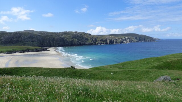
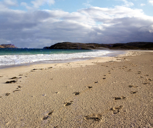
Mullach a' Bhaile Images

Images are sourced within 2km of 58.222151/-6.9579422 or Grid Reference NB0936. Thanks to Geograph Open Source API. All images are credited.

Lazy Beds at Tràigh na Beirigh Ridges formed by hand digging of fields.  These one are unusual in that some of the ridges are lined with small stones.
Lazy Beds at Tràigh na Beirigh
Ridges formed by hand digging of fields. These one are unusual in that some of the ridges are lined with small stones.
Gob Geòdha nam Bradan
Sheepfold at Tobha Mòr
Sheepfold and boundary wall near Tobha Mòr
Rocky surface at Eala Sheadha
Eastern side of the Eala Sheadha Headland
Berie Sands Caravan Park Busy site at Traigh na Beirigh with many caravans parked on the machair above the extensive sands.
Berie Sands Caravan Park
Busy site at Traigh na Beirigh with many caravans parked on the machair above the extensive sands.
A' Bheirigh from Suaineabhal
Tràigh na Beirigh In the 1960's this was a deserted beach.  Now it has to be shared with caravanners.
Tràigh na Beirigh
In the 1960's this was a deserted beach. Now it has to be shared with caravanners.
Tràigh na Beirigh A perfect crescent beach
Tràigh na Beirigh
A perfect crescent beach
Traigh na Berie
Traigh na Berie
A' Bheirigh
A' Bheirigh
Sunrise, Gridig
Sunrise, Gridig
Beach at Pabaigh Mor
Traigh na Berie
Traigh na Berie
Tràigh na Beirigh and Pabaigh Mòr
Tràigh na Beirigh
Tràigh na Beirigh
Traigh na Beirigh beach Lewis Looking out from the beach just in front of the Caravan site towards the headland at Kneep on the left and Pabaigh Mor on the right.
Traigh na Beirigh beach Lewis
Looking out from the beach just in front of the Caravan site towards the headland at Kneep on the left and Pabaigh Mor on the right.
Show me another place!

Mullach a' Bhaile is located at Grid Ref: NB0936 (Lat: 58.222151, Lng: -6.9579422)

Unitary Authority: Na h-Eileanan an Iar

Police Authority: Highlands and Islands

What 3 Words

///work.midfield.stutter. Near Carloway, Na h-Eileanan Siar

Related Wikis

Kneep

Kneep (Scottish Gaelic: Cnìp) is a village on the Isle of Lewis, in the Outer Hebrides, Scotland. Kneep is within the parish of Uig.Various archaeological...

Cliff, Lewis

Cliff (Scottish Gaelic: Cliobh) is a small settlement on the Isle of Lewis, in the Outer Hebrides, Scotland. Cliff is within the parish of Uig. The settlement...

Pabaigh Mòr

Pabay Mòr or Pabaigh Mòr is an uninhabited island in the Outer Hebrides of Scotland. == History == The island's name comes from papey, an Old Norse name...

Loch na Berie

Loch Na Berie is a broch in the Outer Hebrides of Scotland, located approximately 400 yards from the shore, and is thought to have been located on an island...

Nearby Amenities

Located within 500m of 58.222151,-6.9579422
Passing Place
Lat/Long: 58.2194395/-6.9634875
Passing Place
Lat/Long: 58.2200761/-6.9624563
Passing Place
Lat/Long: 58.2209038/-6.9621875
Passing Place
Lat/Long: 58.2234255/-6.9605884
Passing Place
Lat/Long: 58.2244545/-6.9585468
Passing Place
Lat/Long: 58.2253716/-6.9537288
Barrier: cattle_grid
Lat/Long: 58.2223706/-6.9503354
Bhaltos
Name En: Valtos
Name Gd: Bhaltos
Place: village
Lat/Long: 58.2253584/-6.9546379
Bus Stop
Valtos Phonebox
Naptan AtcoCode: 6010731875
Naptan Bearing: NW
Naptan CommonName: Valtos Phonebox
Naptan Indicator: Phonebox
Naptan Landmark: Valtos Phonebox
Naptan NaptanCode: 94723946
Naptan Street: Valtos Phonebox
Naptan Verified: no
Source: naptan_import
Lat/Long: 58.2228533/-6.9523251
Tourism: picnic_site
Lat/Long: 58.221916/-6.9621875
Barrier: cattle_grid
Lat/Long: 58.2256516/-6.9553346
Turning Circle
Lat/Long: 58.2251682/-6.9516195
Telephone
Booth: K6
Covered: booth
Operator: BT
Phone: +44 1851 672287
Source: survey
Lat/Long: 58.2227773/-6.9522262
Turning Circle
Lat/Long: 58.2234723/-6.9536739
Post Box
Collection Times: Mo-Fr 10:00; Sa 10:00
Operator: Royal Mail
Post Box Type: lamp
Ref: HS2 155
Royal Cypher: scottish_crown
Source: survey
Lat/Long: 58.2227791/-6.9522588
Passing Place
Lat/Long: 58.2195754/-6.9624377
Barrier: cattle_grid
Lat/Long: 58.2255227/-6.9584607
Passing Place
Lat/Long: 58.2218401/-6.9546331
Post Box
Collection Times: Mo-Fr 10:00; Sa 10:00
Operator: Royal Mail
Post Box Type: lamp
Ref: HS2 163
Royal Cypher: scottish_crown
Source: survey
Lat/Long: 58.2249569/-6.9568269
Barrier: cattle_grid
Lat/Long: 58.2222785/-6.9516286
Turning Circle
Lat/Long: 58.2217791/-6.9524734
Passing Place
Lat/Long: 58.2204549/-6.9582845
Turning Circle
Lat/Long: 58.2204001/-6.9577453
Passing Place
Lat/Long: 58.2214025/-6.9559383
Barrier: cattle_grid
Lat/Long: 58.22452/-6.9530205
Barrier: cattle_grid
Lat/Long: 58.2250136/-6.958102
Barrier: cattle_grid
Lat/Long: 58.2238704/-6.9544328
Power: pole
Lat/Long: 58.2225966/-6.9525371
Power: pole
Lat/Long: 58.2219794/-6.9539605
Power: pole
Lat/Long: 58.2215234/-6.9552228
Power: pole
Lat/Long: 58.2210179/-6.9561364
Power: pole
Lat/Long: 58.2205458/-6.9573698
Power: pole
Lat/Long: 58.2201007/-6.9586357
Power: pole
Lat/Long: 58.2197055/-6.9598297
Power: pole
Lat/Long: 58.2193698/-6.9608212
Power: pole
Lat/Long: 58.2189658/-6.9620249
Power: pole
Lat/Long: 58.2188876/-6.9631414
Power: pole
Lat/Long: 58.2195139/-6.9632912
Power: pole
Lat/Long: 58.2194702/-6.9618173
Power: pole
Lat/Long: 58.219746/-6.9612907
Power: pole
Lat/Long: 58.2199456/-6.9609032
Power: pole
Lat/Long: 58.2249521/-6.9568957
Power: pole
Lat/Long: 58.2243515/-6.9550768
Power: pole
Lat/Long: 58.2244982/-6.9534158
Power: pole
Lat/Long: 58.2245301/-6.9539504
Power: pole
Lat/Long: 58.2242388/-6.9559046
Power: pole
Lat/Long: 58.2247398/-6.9562057
Power: pole
Lat/Long: 58.2241078/-6.9544235
Power: pole
Lat/Long: 58.2248628/-6.9531935
Power: pole
Lat/Long: 58.2241141/-6.953578
Power: pole
Lat/Long: 58.2236758/-6.9539786
Power: pole
Lat/Long: 58.2257038/-6.954306
Power: pole
Lat/Long: 58.2254498/-6.9537246
Power: pole
Lat/Long: 58.220843/-6.9510444
Power: pole
Lat/Long: 58.2207929/-6.9521391
Power: pole
Lat/Long: 58.2207954/-6.9536874
Power: pole
Lat/Long: 58.2210902/-6.9543014
Power: pole
Lat/Long: 58.2220024/-6.9500263
Power: pole
Lat/Long: 58.2237819/-6.9507586
Power: pole
Lat/Long: 58.2237088/-6.9519454
Power: pole
Lat/Long: 58.2229687/-6.9530177
Power: pole
Lat/Long: 58.2257651/-6.9579919
Power: pole
Lat/Long: 58.2255964/-6.9575976
Power: pole
Lat/Long: 58.2253986/-6.9571188
Power: pole
Lat/Long: 58.225292/-6.9561344
Power: pole
Lat/Long: 58.2253322/-6.9560419
Power: pole
Lat/Long: 58.2255144/-6.9556637
Power: pole
Lat/Long: 58.2258775/-6.9557031
Power: pole
Lat/Long: 58.2250081/-6.9534522
Power: pole
Lat/Long: 58.2252327/-6.9529493
Power: pole
Lat/Long: 58.2255201/-6.9527575
Power: pole
Lat/Long: 58.225768/-6.9550964
Barrier: cattle_grid
Lat/Long: 58.2257268/-6.9544215
Passing Place
Lat/Long: 58.2223166/-6.9614368
Power: pole
Lat/Long: 58.223618/-6.9558056
Power: pole
Lat/Long: 58.2229922/-6.9556777
Power: pole
Lat/Long: 58.2222584/-6.9554369
Passing Place
Lat/Long: 58.222666/-6.9515787
Power: pole
Lat/Long: 58.2233519/-6.9535366
Passing Place
Lat/Long: 58.2255472/-6.955256
Barrier: cattle_grid
Lat/Long: 58.2246243/-6.9565776
Power: pole
Lat/Long: 58.2234006/-6.9513012
Power: pole
Lat/Long: 58.2229888/-6.9519423
Passing Place
Lat/Long: 58.224038/-6.9595267
The data included in this document is from www.openstreetmap.org. The data is made available under ODbL.

Have you been to Mullach a' Bhaile?

Leave your review of Mullach a' Bhaile below (or comments, questions and feedback).