Kneep

Settlement in Ross-shire

Scotland

Kneep

Lazy Beds at Tràigh na Beirigh Ridges formed by hand digging of fields.  These one are unusual in that some of the ridges are lined with small stones.
Lazy Beds at Tràigh na Beirigh Credit: Sandy Gerrard

Kneep is a small coastal village located in the county of Ross-shire, on the northwest coast of Scotland. Situated on the Isle of Lewis, which forms part of the Outer Hebrides archipelago, Kneep is surrounded by stunning natural beauty and offers a tranquil and picturesque setting for residents and visitors alike.

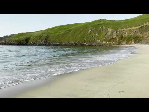
The village is characterized by its rugged coastline, with rocky cliffs and sandy beaches providing breathtaking views of the Atlantic Ocean. The area is known for its rich wildlife, including seabirds, seals, and occasionally dolphins, making it a popular spot for nature lovers and birdwatchers.

Kneep is a close-knit community with a small population, and its residents are predominantly involved in traditional industries such as fishing and farming. The village has a strong connection to its Gaelic roots, with the Gaelic language still spoken and celebrated by many locals.

Despite its small size, Kneep offers a range of amenities for its residents, including a local shop, a pub, and a community center. The village is also home to a primary school, ensuring that the younger generation has access to education within their community.

For those seeking outdoor activities, Kneep offers a variety of opportunities, including coastal walks, fishing, and water sports. The village is also within close proximity to other popular tourist attractions on the Isle of Lewis, such as the Callanish Standing Stones and the beautiful white sandy beaches of Luskentyre.

Overall, Kneep is a charming and idyllic village that offers a peaceful retreat for those looking to immerse themselves in the natural beauty and rich cultural heritage of the Scottish Highlands.

If you have any feedback on the listing, please let us know in the comments section below.

Kneep Images

Images are sourced within 2km of 58.221564/-6.9482775 or Grid Reference NB0936. Thanks to Geograph Open Source API. All images are credited.

Lazy Beds at Tràigh na Beirigh Ridges formed by hand digging of fields.  These one are unusual in that some of the ridges are lined with small stones.
Lazy Beds at Tràigh na Beirigh
Ridges formed by hand digging of fields. These one are unusual in that some of the ridges are lined with small stones.
Sheepfold at Tobha Mòr
Sheepfold and boundary wall near Tobha Mòr
Rocky surface at Eala Sheadha
Eastern side of the Eala Sheadha Headland
Berie Sands Caravan Park Busy site at Traigh na Beirigh with many caravans parked on the machair above the extensive sands.
Berie Sands Caravan Park
Busy site at Traigh na Beirigh with many caravans parked on the machair above the extensive sands.
A' Bheirigh from Suaineabhal
Lochan at Cragavig An old boundary wall snakes across the moorland
Lochan at Cragavig
An old boundary wall snakes across the moorland
Tràigh na Beirigh In the 1960's this was a deserted beach.  Now it has to be shared with caravanners.
Tràigh na Beirigh
In the 1960's this was a deserted beach. Now it has to be shared with caravanners.
Tràigh na Beirigh A perfect crescent beach
Tràigh na Beirigh
A perfect crescent beach
A rocky buttress contains Tràigh na Beirigh
Traigh na Berie
Traigh na Berie
Tràigh na Beirigh from the east
A' Bheirigh
A' Bheirigh
Sunrise, Gridig
Sunrise, Gridig
Beach at Pabaigh Mor
Traigh na Berie
Traigh na Berie
Show me another place!

Kneep is located at Grid Ref: NB0936 (Lat: 58.221564, Lng: -6.9482775)

Unitary Authority: Na h-Eileanan an Iar

Police Authority: Highlands and Islands

Also known as: Cnip

What 3 Words

///stripped.disbelief.hindered. Near Carloway, Na h-Eileanan Siar

Related Wikis

Kneep

Kneep (Scottish Gaelic: Cnìp) is a village on the Isle of Lewis, in the Outer Hebrides, Scotland. Kneep is within the parish of Uig.Various archaeological...

Cliff, Lewis

Cliff (Scottish Gaelic: Cliobh) is a small settlement on the Isle of Lewis, in the Outer Hebrides, Scotland. Cliff is within the parish of Uig. The settlement...

Loch na Berie

Loch Na Berie is a broch in the Outer Hebrides of Scotland, located approximately 400 yards from the shore, and is thought to have been located on an island...

Pabaigh Mòr

Pabay Mòr or Pabaigh Mòr is an uninhabited island in the Outer Hebrides of Scotland. == History == The island's name comes from papey, an Old Norse name...

Related Videos

Cliff Beach Isle of Lewis 4K Video

Beautiful remote beach in Lewis and Harris Scotland, Sept. 2023. Wait til the end for photo of beach from above taken at golden ...

Kneep, Isle of Lewis

Kneep (Scottish Gaelic: Cnìp) is a village on the Isle of Lewis, in the Outer Hebrides, Scotland. Kneep is within the parish of Uig.

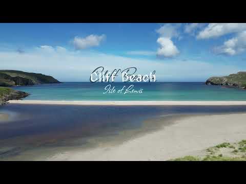
Cliff Beach - Isle of Lewis - Outer Hebrides - Scotland | 4K | DJI Mini 3 Pro

Cliff Beach is located on the western side of Isle of Lewis (Outer Hebrides in Scotland). It is beautiful stretch of light cream sand ...

Nearby Amenities

Located within 500m of 58.221564,-6.9482775
Barrier: cattle_grid
Lat/Long: 58.2223706/-6.9503354
Passing Place
Lat/Long: 58.2219525/-6.9489152
Bus Stop
Valtos Phonebox
Naptan AtcoCode: 6010731875
Naptan Bearing: NW
Naptan CommonName: Valtos Phonebox
Naptan Indicator: Phonebox
Naptan Landmark: Valtos Phonebox
Naptan NaptanCode: 94723946
Naptan Street: Valtos Phonebox
Naptan Verified: no
Source: naptan_import
Lat/Long: 58.2228533/-6.9523251
Passing Place
Lat/Long: 58.2214045/-6.9456472
Turning Circle
Lat/Long: 58.2251682/-6.9516195
Telephone
Booth: K6
Covered: booth
Operator: BT
Phone: +44 1851 672287
Source: survey
Lat/Long: 58.2227773/-6.9522262
Turning Circle
Lat/Long: 58.2234723/-6.9536739
Post Box
Collection Times: Mo-Fr 10:00; Sa 10:00
Operator: Royal Mail
Post Box Type: lamp
Ref: HS2 155
Royal Cypher: scottish_crown
Source: survey
Lat/Long: 58.2227791/-6.9522588
Passing Place
Lat/Long: 58.2218401/-6.9546331
Barrier: cattle_grid
Lat/Long: 58.2222785/-6.9516286
Turning Circle
Lat/Long: 58.2217791/-6.9524734
Cnìp
Name En: Kneep
Name Gd: Cnìp
Place: village
Wikidata: Q6421916
Wikipedia: en:Kneep
Lat/Long: 58.2215979/-6.9470186
Name En: view
Tourism: viewpoint
Lat/Long: 58.2197456/-6.9431175
Passing Place
Lat/Long: 58.2214025/-6.9559383
Barrier: cattle_grid
Lat/Long: 58.22452/-6.9530205
Barrier: cattle_grid
Lat/Long: 58.2238704/-6.9544328
Power: pole
Lat/Long: 58.2225966/-6.9525371
Power: pole
Lat/Long: 58.2219794/-6.9539605
Power: pole
Lat/Long: 58.2215234/-6.9552228
Power: pole
Lat/Long: 58.2210179/-6.9561364
Power: pole
Lat/Long: 58.2244982/-6.9534158
Power: pole
Lat/Long: 58.2245301/-6.9539504
Power: pole
Lat/Long: 58.2241078/-6.9544235
Power: pole
Lat/Long: 58.2248628/-6.9531935
Power: pole
Lat/Long: 58.2241141/-6.953578
Power: pole
Lat/Long: 58.2236758/-6.9539786
Power: pole
Lat/Long: 58.218496/-6.943799
Power: pole
Lat/Long: 58.2189938/-6.9444538
Power: pole
Lat/Long: 58.219365/-6.945629
Power: pole
Lat/Long: 58.2197863/-6.947011
Power: pole
Lat/Long: 58.2202032/-6.9483383
Power: pole
Lat/Long: 58.2208234/-6.9495335
Power: pole
Lat/Long: 58.220843/-6.9510444
Power: pole
Lat/Long: 58.2207929/-6.9521391
Power: pole
Lat/Long: 58.2207954/-6.9536874
Power: pole
Lat/Long: 58.2210902/-6.9543014
Power: pole
Lat/Long: 58.2220024/-6.9500263
Power: pole
Lat/Long: 58.2218266/-6.948594
Power: pole
Lat/Long: 58.2213006/-6.9478161
Power: pole
Lat/Long: 58.2209796/-6.9474251
Power: pole
Lat/Long: 58.2209468/-6.9473892
Power: pole
Lat/Long: 58.2208608/-6.946971
Power: pole
Lat/Long: 58.2207179/-6.9465248
Power: pole
Lat/Long: 58.2204468/-6.9458488
Power: pole
Lat/Long: 58.2215965/-6.9449559
Power: pole
Lat/Long: 58.2213374/-6.9459061
Power: pole
Lat/Long: 58.2211393/-6.9466446
Power: pole
Lat/Long: 58.2237819/-6.9507586
Power: pole
Lat/Long: 58.2237088/-6.9519454
Power: pole
Lat/Long: 58.2229687/-6.9530177
Passing Place
Lat/Long: 58.2186472/-6.9425573
Power: pole
Lat/Long: 58.2250081/-6.9534522
Power: pole
Lat/Long: 58.2252327/-6.9529493
Power: pole
Lat/Long: 58.223618/-6.9558056
Power: pole
Lat/Long: 58.2229922/-6.9556777
Power: pole
Lat/Long: 58.2222584/-6.9554369
Passing Place
Lat/Long: 58.222666/-6.9515787
Power: pole
Lat/Long: 58.2233519/-6.9535366
Power: pole
Lat/Long: 58.2234006/-6.9513012
Power: pole
Lat/Long: 58.2229888/-6.9519423
Power: pole
Lat/Long: 58.220848/-6.9487852
The data included in this document is from www.openstreetmap.org. The data is made available under ODbL.

Have you been to Kneep?

Leave your review of Kneep below (or comments, questions and feedback).