Ditton Enclosure

Wood, Forest in Shropshire

England

Ditton Enclosure

Grassland beneath the Brown Clee Pasture at Lower Earnstrey.
Grassland beneath the Brown Clee Credit: Richard Webb

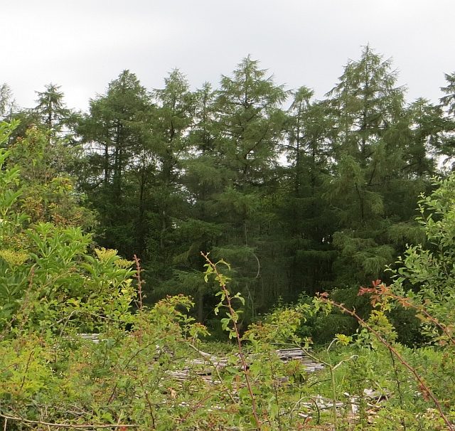
Ditton Enclosure is a picturesque woodland area located in Shropshire, England. Situated in the heart of the county, this enchanting forest covers an area of approximately 100 acres. It is a popular destination for nature enthusiasts, hikers, and families seeking a peaceful retreat in the midst of nature.

The woodland is characterized by its dense and diverse tree population, which includes oak, beech, birch, and hazel trees, among others. These towering trees create a serene and tranquil atmosphere, providing ample shade and shelter for various wildlife species that call Ditton Enclosure their home.

Walking through Ditton Enclosure, visitors can explore a network of well-maintained footpaths that wind their way through the forest. These paths offer breathtaking views of the surrounding countryside and provide opportunities to spot a plethora of wildlife, including deer, squirrels, and a variety of bird species.

The forest is also home to a small pond, adding to its natural charm and attracting additional wildlife such as frogs and dragonflies. Alongside the pond, visitors can find picnic areas where they can relax and enjoy the peaceful surroundings.

Ditton Enclosure is open to the public year-round, with no admission fees. It is managed by the local authority, ensuring the preservation and maintenance of this beautiful woodland for future generations to enjoy.

Overall, Ditton Enclosure is a hidden gem in Shropshire, offering a serene and picturesque escape from the hustle and bustle of everyday life. Whether it's a leisurely stroll, a family picnic, or a wildlife-spotting adventure, this enchanting forest has something to offer for everyone.

If you have any feedback on the listing, please let us know in the comments section below.

Ditton Enclosure Images

Images are sourced within 2km of 52.480424/-2.5879714 or Grid Reference SO6087. Thanks to Geograph Open Source API. All images are credited.

Grassland beneath the Brown Clee Pasture at Lower Earnstrey.
Grassland beneath the Brown Clee
Pasture at Lower Earnstrey.
Driveway, Hillside Road climbing to houses on the northern slopes of the Brown Clee.
Driveway, Hillside
Road climbing to houses on the northern slopes of the Brown Clee.
A drinking trough, Hillside A plastic successor to the commonly seen galvanised field drinking troughs.
A drinking trough, Hillside
A plastic successor to the commonly seen galvanised field drinking troughs.
Tracks in the woods
Tracks in the woods
Grown out hedges Remains of hedges where most have the plants have been removed leaving a few survivors as trees.
Grown out hedges
Remains of hedges where most have the plants have been removed leaving a few survivors as trees.
Old building frame on Abdon Burf (2)
Old building frame on Abdon Burf (1)
Stone crushing plant (ruins)
A very cold pond on Abdon Burf
Pond near the masts
Pond near the masts
Start of the path for Brown Clee Hill
Brown Clee Hill The trig point was still here in 2002 and summit is 150 metres north of trig.
Shropshire (1974) administrative county top, Shropshire historic county top and Shropshire current county/UA top.
Name: Brown Clee Hill
Hill number: 2837
Height: 540m / 1772ft
Area: 38A: Shropshire
Class: Ma,5,CoH,CoU, CoA
Grid ref: SO 59375 86705
Summit feature: heathery mound near masts
Drop: 373m
Col: 167m  SO610955
Brown Clee Hill
The trig point was still here in 2002 and summit is 150 metres north of trig. Shropshire (1974) administrative county top, Shropshire historic county top and Shropshire current county/UA top. Name: Brown Clee Hill Hill number: 2837 Height: 540m / 1772ft Area: 38A: Shropshire Class: Ma,5,CoH,CoU, CoA Grid ref: SO 59375 86705 Summit feature: heathery mound near masts Drop: 373m Col: 167m SO610955
Brown Clee Hill
Brown Clee Hill
Pasture, Great Leasows A parkland setting between the former munitions depot at Ditton Priors and Brown Clee.
Pasture, Great Leasows
A parkland setting between the former munitions depot at Ditton Priors and Brown Clee.
Woodland edge, Ditton Priors The wood is on the site of a Royal Navy armaments depot, later used by US forces until closure in 1968. There is a timber works in the foreground behind a rather high hedge.
Woodland edge, Ditton Priors
The wood is on the site of a Royal Navy armaments depot, later used by US forces until closure in 1968. There is a timber works in the foreground behind a rather high hedge.
Barley beneath Brown Clee Arable land near Ditton Priors.
Barley beneath Brown Clee
Arable land near Ditton Priors.
Field, Cleobury North A grass field beside the B4364.
Field, Cleobury North
A grass field beside the B4364.
Cleobury North one way system Ditton Priors generates commercial traffic and there is a small one way system for access to the B4364.
Cleobury North one way system
Ditton Priors generates commercial traffic and there is a small one way system for access to the B4364.
Show me another place!

Ditton Enclosure is located at Grid Ref: SO6087 (Lat: 52.480424, Lng: -2.5879714)

Unitary Authority: Shropshire

Police Authority: West Mercia

What 3 Words

///clenching.volunteered.deployed. Near Cardington, Shropshire

Related Wikis

Brown Clee Hill

Brown Clee Hill is the highest hill in the rural English county of Shropshire, at 540 metres (1,770 ft) above sea level. It is one of the Clee Hills,...

Ditton Priors

Ditton Priors is a village and civil parish in south Shropshire, England. Historically, it was also known as Priors Ditton. The nearest town is Bridgnorth...

Cleobury North

Cleobury North is a civil parish and small village in south east Shropshire, England. It is situated on the B4364 southwest of the market town of Bridgnorth...

Cleobury North Crossing railway station

Cleobury North Crossing railway station was a station in Cleobury North, Shropshire, England. The station was opened in 1908 and closed in 1938. ��2�...

Nearby Amenities

Located within 500m of 52.480424,-2.5879714
Barrier: cattle_grid
Lat/Long: 52.4819549/-2.5935694
Building: yes
Lat/Long: 52.4788952/-2.5937526
Barrier: stile
Material: wood
Source: survey;gps
Stile: stepover
Lat/Long: 52.4781356/-2.5822199
Bench
Source: survey;gps
Lat/Long: 52.479915/-2.5818193
Bench
Source: survey;gps
Lat/Long: 52.4805685/-2.5817147
Access: no
Barrier: stile
Foot: yes
Material: wood
Stile: stepover
Lat/Long: 52.4819393/-2.5935607
The data included in this document is from www.openstreetmap.org. The data is made available under ODbL.

Have you been to Ditton Enclosure?

Leave your review of Ditton Enclosure below (or comments, questions and feedback).