Alder Root Wood

Wood, Forest in Lancashire

England

Alder Root Wood

St Oswalds Church, Winwick
St Oswalds Church, Winwick Credit: thejackrustles

Alder Root Wood is a picturesque forest located in Lancashire, England. Covering an area of approximately 200 acres, this woodland is a popular destination for nature enthusiasts and hikers alike. The forest is named after the alder trees that dominate its landscape, providing a serene and tranquil environment for visitors to enjoy.

The wood is characterized by its rich biodiversity, boasting a wide variety of flora and fauna. The dense canopy of alder trees creates a shaded and cool atmosphere, making it an ideal habitat for various bird species, including woodpeckers, owls, and finches. The forest floor is adorned with an array of wildflowers and ferns, adding to its natural beauty.

Alder Root Wood offers several well-maintained walking trails that meander through the forest, allowing visitors to explore its hidden gems. These trails offer breathtaking views of the surrounding countryside, making it a popular spot for nature photography. Along the paths, one may come across small streams and ponds, enhancing the serenity of the woodland.

The forest also provides a habitat for various mammals, such as rabbits, squirrels, and deer. Nature enthusiasts may be lucky enough to catch a glimpse of these creatures as they go about their daily activities.

Overall, Alder Root Wood is a captivating forest that captivates visitors with its natural beauty and tranquility. Whether it's a leisurely stroll or an adventurous hike, this woodland offers a peaceful escape from the hustle and bustle of everyday life.

If you have any feedback on the listing, please let us know in the comments section below.

Alder Root Wood Images

Images are sourced within 2km of 53.435235/-2.6187149 or Grid Reference SJ5893. Thanks to Geograph Open Source API. All images are credited.

St Oswalds Church, Winwick
OS 1GL Bolt - Winwick, Church <span class="nowrap"><a title="https://www.bench-marks.org.uk/bm26641" rel="nofollow ugc noopener" href="https://www.bench-marks.org.uk/bm26641">Link</a><img style="margin-left:2px;" alt="External link" title="External link - shift click to open in new window" src="https://s1.geograph.org.uk/img/external.png" width="10" height="10"/></span>
OS 1GL Bolt - Winwick, Church
Close up of 1GL Bolt <span class="nowrap"><a title="https://www.bench-marks.org.uk/bm26641" rel="nofollow ugc noopener" href="https://www.bench-marks.org.uk/bm26641">Link</a><img style="margin-left:2px;" alt="External link" title="External link - shift click to open in new window" src="https://s1.geograph.org.uk/img/external.png" width="10" height="10"/></span>
Close up of 1GL Bolt
Door St Oswalds Church, Winwick
Golborne Rd, Winwick
Hermitage Green Lane
Modern Milestone, Sankey Canal On the Sankey Trail, the path of the canal.

Inscription: 6 / Mile to / Ferry Lock

Milestone Society National ID: SAN-06R
Modern Milestone, Sankey Canal
On the Sankey Trail, the path of the canal. Inscription: 6 / Mile to / Ferry Lock Milestone Society National ID: SAN-06R
Modern Canal Milestone, Sankey Canal A modern replacement for the milestone preserved in the Sankey Visitor Centre. see <a href="https://www.geograph.org.uk/photo/6978401">SJ5396 : Old Milestone, Sankey Canal</a>

Milestone Society National ID: SAN-07R
Modern Canal Milestone, Sankey Canal
A modern replacement for the milestone preserved in the Sankey Visitor Centre. see SJ5396 : Old Milestone, Sankey Canal Milestone Society National ID: SAN-07R
Emmanuel Parish Church, Wargrave, Newton-le-Willows
Entrance Emmanuel Parish Church, Wargrave, Newton-le-Willows
OS 1GL Bolt - Wargrave, Emmanuel Church <span class="nowrap"><a title="https://www.bench-marks.org.uk/bm32981" rel="nofollow ugc noopener" href="https://www.bench-marks.org.uk/bm32981">Link</a><img style="margin-left:2px;" alt="External link" title="External link - shift click to open in new window" src="https://s1.geograph.org.uk/img/external.png" width="10" height="10"/></span>
OS 1GL Bolt - Wargrave, Emmanuel Church
Location of OS 1GL Bolt - Wargrave, Emmanuel Church
OS Pivot - Wargrave, Emmanuel Parish Church <span class="nowrap"><a title="https://www.bench-marks.org.uk/bm149237" rel="nofollow ugc noopener" href="https://www.bench-marks.org.uk/bm149237">Link</a><img style="margin-left:2px;" alt="External link" title="External link - shift click to open in new window" src="https://s1.geograph.org.uk/img/external.png" width="10" height="10"/></span>
OS Pivot - Wargrave, Emmanuel Parish Church
Location of OS Pivot - Wargrave, Emmanuel Parish Church
Hermitage Green Lane near Winwick
M62 The M62 is the west to east trans-Pennine motorway. It is 107 miles long running from Liverpool to Hull. It was built between 1971 and 1976. At Windy Hill it is 372m above sea level, making it the highest point on any British motorway.
Wikipedia: <span class="nowrap"><a title="http://en.wikipedia.org/wiki/M62_motorway" rel="nofollow ugc noopener" href="http://en.wikipedia.org/wiki/M62_motorway">Link</a><img style="margin-left:2px;" alt="External link" title="External link - shift click to open in new window" src="https://s1.geograph.org.uk/img/external.png" width="10" height="10"/></span>
M62
The M62 is the west to east trans-Pennine motorway. It is 107 miles long running from Liverpool to Hull. It was built between 1971 and 1976. At Windy Hill it is 372m above sea level, making it the highest point on any British motorway. Wikipedia: LinkExternal link
Junction pylon
Junction pylon
Alder Root Farm
Alder Root Farm
Show me another place!

Alder Root Wood is located at Grid Ref: SJ5893 (Lat: 53.435235, Lng: -2.6187149)

Unitary Authority: Warrington

Police Authority: Cheshire

What 3 Words

///adjusting.whoever.kicked. Near Winwick, Cheshire

Related Wikis

Winwick rail crash

The Winwick rail crash took place at Winwick Junction, near Warrington on the London, Midland and Scottish Railway, on 28 September 1934. Two trains collided...
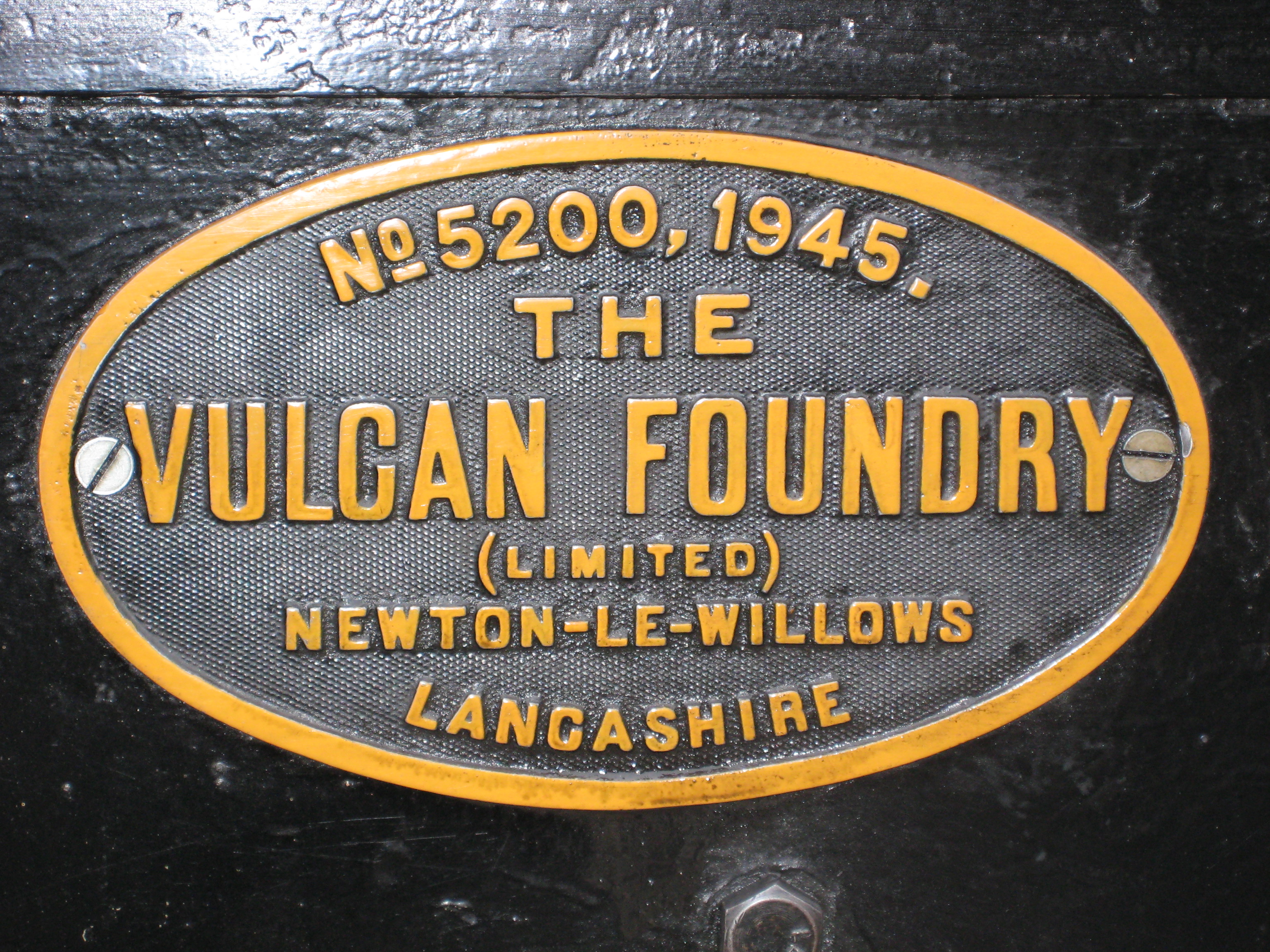
Vulcan Foundry

The Vulcan Foundry Limited was an English locomotive builder sited at Newton-le-Willows, Lancashire (now Merseyside). == History == The Vulcan Foundry...

Battle of Winwick

The Battle of Winwick (also known as the Battle of Red Bank) was fought on 19 August 1648 near the Lancashire village of Winwick between part of a Royalist...

Winwick Hospital

Winwick Hospital was a mental health facility at Winwick, Cheshire, England. == History == The hospital site was previously part of the Winwick Hall estate...

Nearby Amenities

Located within 500m of 53.435235,-2.6187149
Traffic Calming: cushion
Lat/Long: 53.4379488/-2.6247065
Power: tower
Lat/Long: 53.4356636/-2.6229046
Power: tower
Lat/Long: 53.4352732/-2.6185772
Power: tower
Lat/Long: 53.4352598/-2.614559
Railway: switch
Lat/Long: 53.4310643/-2.6209163
Railway: switch
Lat/Long: 53.4314096/-2.6212854
Railway: switch
Lat/Long: 53.4317923/-2.6216314
Railway: switch
Lat/Long: 53.43223/-2.6220455
Railway: switch
Lat/Long: 53.4325814/-2.6222575
Winwick Junction
Railway: junction
Lat/Long: 53.432811/-2.6223193
Bus Stop
Alder Root Lane
Bus: yes
Departures Board: no
Public Transport: platform
Shelter: no
Lat/Long: 53.4315927/-2.6176637
Bus Stop
Alder Root Lane
Bus: yes
Departures Board: no
Naptan AtcoCode: 069000020220
Naptan NaptanCode: wrgadjw
Public Transport: platform
Shelter: no
Lat/Long: 53.4315753/-2.6174126
Give Way
Direction: forward
Traffic Sign: GB:1003A
Lat/Long: 53.4318501/-2.6181368
Crossing
Crossing: unmarked
Crossing Island: no
Tactile Paving: yes
Lat/Long: 53.4315794/-2.6175298
Communication Mobile Phone: yes
Man Made: mast
Source: survey
Tower Type: communication
Lat/Long: 53.4339533/-2.6214474
St Helens
Board Type: welcome_sign
Direction: 340
Inscription: st.helens;The Heart of the Northwest;Please Drive Safely!
Is In City: Newton-le-Willows
Operator: St Helens Council
Operator Wikidata: Q17022094
Operator Wikipedia: en:St Helens Council
Subject Wikidata: Q153647
Subject Wikipedia: en:St Helens, Merseyside
Traffic Sign: city_limit
Lat/Long: 53.4370163/-2.6242044
Newton-le-Willows
Board Type: welcome_sign
Direction: 160
Information: board
Inscription: Welcome to the Historic Town of;Newton-le-Willows;Part of St.Helens Borough
Is In City: Newton-le-Willows
Operator: St Helens Borough Council
Operator Wikidata: Q17033474
Operator Wikipedia: en:Warrington Borough Council
Subject Wikidata: Q750000
Subject Wikipedia: en:Newton-le-Willows
Tourism: information
Traffic Sign: city_limit
Lat/Long: 53.4370112/-2.6242
The data included in this document is from www.openstreetmap.org. The data is made available under ODbL.

Have you been to Alder Root Wood?

Leave your review of Alder Root Wood below (or comments, questions and feedback).