Great War Plantation

Wood, Forest in Somerset Mendip

England

Great War Plantation

Path by the rugby pitch See <a href="https://www.geograph.org.uk/photo/540254">ST5645 : Rugby ground</a>. This is footpath WS 17/12. On the right is the steep Strawberry Wood.
Path by the rugby pitch Credit: Derek Harper

Great War Plantation, Somerset is a vast woodland area located in the county of Somerset, England. Covering an extensive area, the plantation is characterized by dense forests, towering trees, and a diverse range of flora and fauna. It holds significant historical importance, as it was originally established during the Great War to meet the growing demand for timber for various purposes, including construction and fuel.

The plantation is home to a diverse range of tree species, such as oak, beech, ash, and pine, which thrive in the fertile soil and favorable climate of Somerset. These trees provide a habitat for numerous species of wildlife, including birds, mammals, and insects. The woodland is particularly known for its population of red deer, badgers, foxes, and various bird species, making it a popular spot for nature enthusiasts and birdwatchers.

Great War Plantation offers an extensive network of walking trails and paths, allowing visitors to explore the beauty and tranquility of the woodland. The trails are well-maintained and offer stunning views of the surrounding landscape, making it a perfect destination for hikers, joggers, and families seeking outdoor recreation.

Moreover, the plantation also serves as an important educational and research site, providing opportunities for scientists and researchers to study the ecological dynamics of forests and their impact on the environment. It also plays a crucial role in carbon sequestration, contributing to the fight against climate change.

Overall, Great War Plantation, Somerset is a captivating and historically significant woodland area, offering a sanctuary for wildlife, recreational activities, and opportunities for research and education.

If you have any feedback on the listing, please let us know in the comments section below.

Great War Plantation Images

Images are sourced within 2km of 51.20873/-2.6074994 or Grid Reference ST5745. Thanks to Geograph Open Source API. All images are credited.

Path by the rugby pitch See <a href="https://www.geograph.org.uk/photo/540254">ST5645 : Rugby ground</a>. This is footpath WS 17/12. On the right is the steep Strawberry Wood.
Path by the rugby pitch
See ST5645 : Rugby ground. This is footpath WS 17/12. On the right is the steep Strawberry Wood.
Wells Golf Club Crossed by footpath WS 10/45C, and, according to the map I was carrying (2004 vintage) by footpath WS 10/44, though not according to the club members I encountered en route. Above is King's Castle Wood.
Wells Golf Club
Crossed by footpath WS 10/45C, and, according to the map I was carrying (2004 vintage) by footpath WS 10/44, though not according to the club members I encountered en route. Above is King's Castle Wood.
Wells Golf Club The northwestern corner of the course, with the clubhouse visible in the distance.
Wells Golf Club
The northwestern corner of the course, with the clubhouse visible in the distance.
South Lodge to Mendip Hospital Another view of <a href="https://www.geograph.org.uk/photo/577090">ST5646 : Porter's Lodge, Wells</a>. Built about 1845 and described at <span class="nowrap"><a title="http://www.britishlistedbuildings.co.uk/en-268200-south-lodge-to-mendip-hospital-st-cuthbe" rel="nofollow ugc noopener" href="http://www.britishlistedbuildings.co.uk/en-268200-south-lodge-to-mendip-hospital-st-cuthbe">Link</a><img style="margin-left:2px;" alt="External link" title="External link - shift click to open in new window" src="https://s1.geograph.org.uk/img/external.png" width="10" height="10"/></span> . In the foreground is the Old Frome Road; to the left it meets the B3139 Bath Road.
South Lodge to Mendip Hospital
Another view of ST5646 : Porter's Lodge, Wells. Built about 1845 and described at LinkExternal link . In the foreground is the Old Frome Road; to the left it meets the B3139 Bath Road.
Old Frome Road near South Horrington Some of the new housing close to the road east of Wells. The road to the left is called Gilbert Scott Road, acknowledging the famous Victorian architect who jointly designed the former Mendip Hospital to which the road leads.
Old Frome Road near South Horrington
Some of the new housing close to the road east of Wells. The road to the left is called Gilbert Scott Road, acknowledging the famous Victorian architect who jointly designed the former Mendip Hospital to which the road leads.
Dry valley near South Horrington Crossed by footpath WS 10/46, which climbs the hill behind the large oak right of centre.
Dry valley near South Horrington
Crossed by footpath WS 10/46, which climbs the hill behind the large oak right of centre.
Fields near Great War Plantation A view from footpath WS 10/46, looking towards Combe Cottage between a meadow and a maize field.
Fields near Great War Plantation
A view from footpath WS 10/46, looking towards Combe Cottage between a meadow and a maize field.
Approaching The Warren Bridleway WS 4/15 converges with bridleway WS 4/16 to pass through the gate on the north side of The Warren, the wood to the right. Beyond the gate, the public road (Lyatt Lane) begins.
Approaching The Warren
Bridleway WS 4/15 converges with bridleway WS 4/16 to pass through the gate on the north side of The Warren, the wood to the right. Beyond the gate, the public road (Lyatt Lane) begins.
Lane to Dinder Taken just south of West Lodge on the lane down from Lyatt.
Lane to Dinder
Taken just south of West Lodge on the lane down from Lyatt.
Gates to Sharcombe Park And impressive gateposts. The left-hand one is probably a metre into <a href="https://www.geograph.org.uk/gridref/ST5745">ST5745</a>. Over the hedge is the West Lodge.
Gates to Sharcombe Park
And impressive gateposts. The left-hand one is probably a metre into ST5745. Over the hedge is the West Lodge.
Field by Melly The western of a pair of fields surrounded by woodland. Melly is the wood on the right. Up the hill to the left is Lyatt Covert. The path crossing the field is bridleway WS 4/14.
Field by Melly
The western of a pair of fields surrounded by woodland. Melly is the wood on the right. Up the hill to the left is Lyatt Covert. The path crossing the field is bridleway WS 4/14.
2011 : Church Hill south of Dinder Beyond the tree shadows Shepton Old Road crosses at the bottom of the hill.
2011 : Church Hill south of Dinder
Beyond the tree shadows Shepton Old Road crosses at the bottom of the hill.
2011 : Riverside, Dinder "Dinder (which means "the house in the valley") is a small village 2½ miles west of Shepton Mallet and 2 miles east of Wells in Somerset. It falls within the civil parish of St Cuthbert Out.
The river Sheppey runs alongside the main street of the village."
Dinder is home to the Showering family, creators of Baby Cham.
The above was culled from: <span class="nowrap"><a title="http://en.wikipedia.org/wiki/Dinder" rel="nofollow ugc noopener" href="http://en.wikipedia.org/wiki/Dinder">Link</a><img style="margin-left:2px;" alt="External link" title="External link - shift click to open in new window" src="https://s1.geograph.org.uk/img/external.png" width="10" height="10"/></span>
2011 : Riverside, Dinder
"Dinder (which means "the house in the valley") is a small village 2½ miles west of Shepton Mallet and 2 miles east of Wells in Somerset. It falls within the civil parish of St Cuthbert Out. The river Sheppey runs alongside the main street of the village." Dinder is home to the Showering family, creators of Baby Cham. The above was culled from: LinkExternal link
2011 : Walking the dogs near Sharcombe Park OS Explorer map 141 shows this as a minor road. However, there is a locked barrier at the camera position with footpath access.
2011 : Walking the dogs near Sharcombe Park
OS Explorer map 141 shows this as a minor road. However, there is a locked barrier at the camera position with footpath access.
2011 : South on Sleight Lane Heading toward Dinder at the bottom of the valley.
2011 : South on Sleight Lane
Heading toward Dinder at the bottom of the valley.
2011 : Track to Stacey's Cottage off Sleight Lane Out in the wilds you might think but only two miles from Wells and not much further from Shepton Mallet.
2011 : Track to Stacey's Cottage off Sleight Lane
Out in the wilds you might think but only two miles from Wells and not much further from Shepton Mallet.
2011 : Shepton Old Road heading north east The old road between Wells and Shepton Mallett, bypassed when the A371 passing through Croscombe was made along the bottom of the valley.
2011 : Shepton Old Road heading north east
The old road between Wells and Shepton Mallett, bypassed when the A371 passing through Croscombe was made along the bottom of the valley.
2011 : Shepton Old Road looking east Toward Shepton Mallett.
This is the old Wells to Shepton Mallet road superseded when the A371 was made through Croscombe along the valley below.
The minor road to the left heads south through Worminster and South Wootton.
The names "Shepton" and "Wootton" betray a history of sheep farming in this area.
2011 : Shepton Old Road looking east
Toward Shepton Mallett. This is the old Wells to Shepton Mallet road superseded when the A371 was made through Croscombe along the valley below. The minor road to the left heads south through Worminster and South Wootton. The names "Shepton" and "Wootton" betray a history of sheep farming in this area.
Show me another place!

Great War Plantation is located at Grid Ref: ST5745 (Lat: 51.20873, Lng: -2.6074994)

Administrative County: Somerset

District: Mendip

Police Authority: Avon and Somerset

What 3 Words

///outbound.people.amplifier. Near Wells, Somerset

Related Wikis

King's Castle, Wells

King's Castle is an Iron Age enclosed hilltop settlement at the south-western edge of the Mendip Hills near Wells in Somerset, England. Though there are...

Horrington

Horrington is a collection of three small villages (South Horrington, East Horrington and West Horrington) in the parish of St Cuthbert Out 1 mile (2 km...
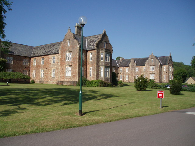
Mendip Hospital

Mendip Hospital opened in 1848 as the Somerset and Bath Pauper Lunatic Asylum at Horrington, near Wells, in the English county of Somerset. As a county...

Dinder House

Dinder House, is a Somerset estate with a small country house Grade II Regency listed building in the village of Dinder, in the civil parish of St Cuthbert...

Dinder

Dinder (which means "the house in the valley") is a small village and former civil parish, now in the parish of St Cuthbert Out, in the Somerset district...

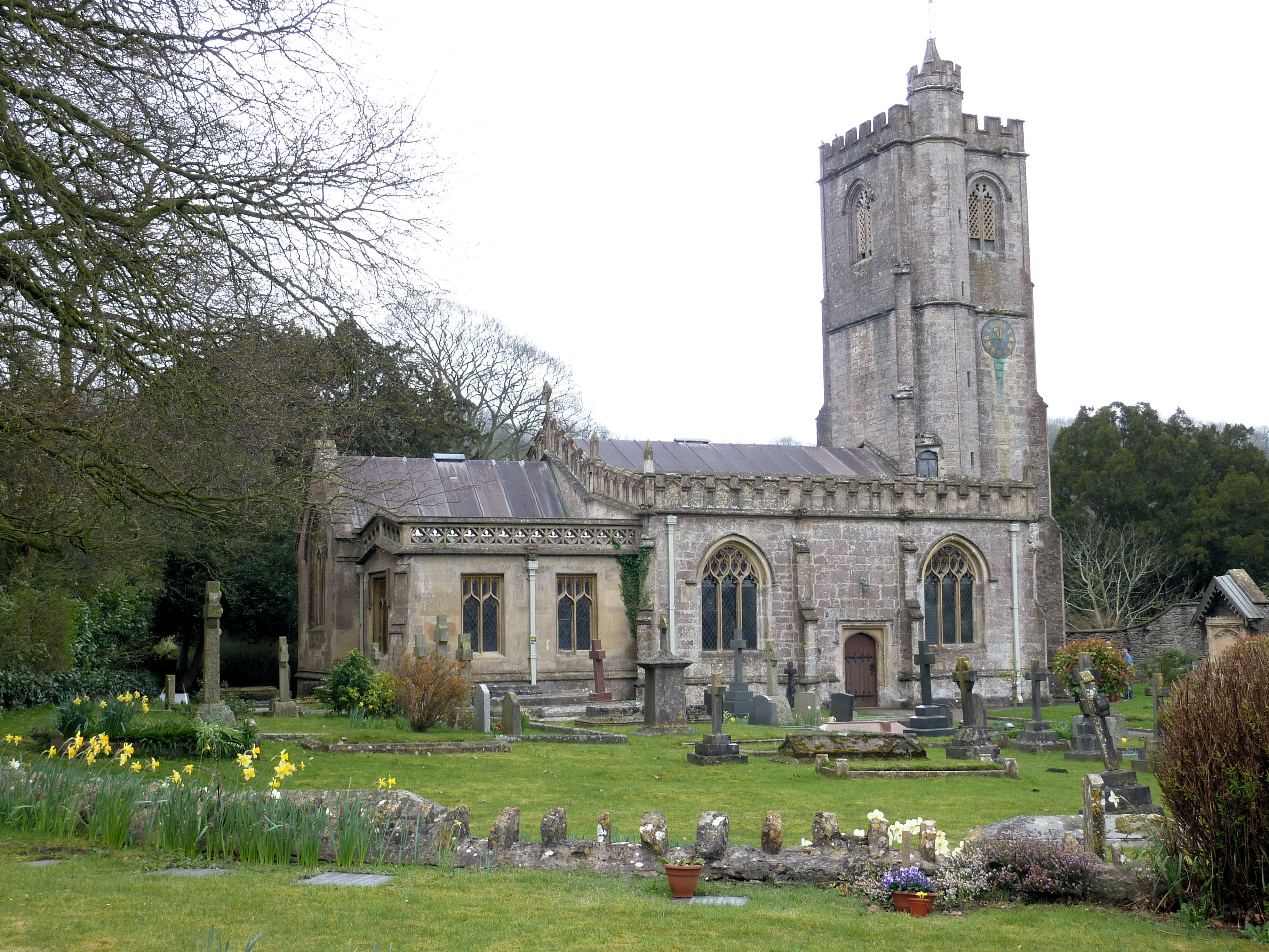
Church of St Michael, Dinder

The Anglican Church of St Michael in Dinder, Somerset, England has Norman origins and was built in the 14th century before being rebuilt in the 15th. It...

St John's Church, East Horrington

St John's Church is a former Church of England church in East Horrington, Somerset, England. It was built in 1838 to the designs of Richard Carver and...

Dulcote Quarry

Dulcote Quarry is a disused limestone quarry at Dulcote, near Wells on the Mendip Hills, Somerset, England. The quarry measures around 600 metres (2,000...

Nearby Amenities

Located within 500m of 51.20873,-2.6074994
Power: pole
Lat/Long: 51.2046628/-2.6104294
Power: pole
Lat/Long: 51.205339/-2.6091816
Power: pole
Lat/Long: 51.206036/-2.6076152
Power: pole
Lat/Long: 51.2067593/-2.6060909
Power: pole
Lat/Long: 51.2073113/-2.6049544
Power: pole
Lat/Long: 51.2084791/-2.6051288
Power: pole
Lat/Long: 51.2097543/-2.6052851
Power: pole
Lat/Long: 51.21047/-2.605347
Power: pole
Lat/Long: 51.2110124/-2.6054084
Power: pole
Lat/Long: 51.2117658/-2.6048191
The data included in this document is from www.openstreetmap.org. The data is made available under ODbL.

Have you been to Great War Plantation?

Leave your review of Great War Plantation below (or comments, questions and feedback).