Brunthwaite Wood

Wood, Forest in Westmorland South Lakeland

England

Brunthwaite Wood

Old Milestone, B6254, near Crosslands Farm, Parish of Old Hutton and Holmescales The milestone is located 450m North of the farm on the grass embankment, on the East side of the road. Carved stone post, Kirkby Kendal stone design, erected by the Kendal, Kirkby Lonsdale, Milnthorpe turnpike trust in the 19th century.

Repainted by John Heap, John Shorrock and Arthur Robinson from Old Hutton & Holmescales Parish Council, August 2021. See  <a title="https://www.geograph.org.uk/photo/6864905" href="https://www.geograph.org.uk/photo/6864905">Link</a> taken before the repainting.

Inscription reads:- KIRKBY / LONSDALE / 6 : : KENDAL / 6
Carved benchmark and rivet on top.

Grade II listed. List Entry Number: 1087299 <span class="nowrap"><a title="https://historicengland.org.uk/listing/the-list/list-entry/1087299" rel="nofollow ugc noopener" href="https://historicengland.org.uk/listing/the-list/list-entry/1087299">Link</a><img style="margin-left:2px;" alt="External link" title="External link - shift click to open in new window" src="https://s1.geograph.org.uk/img/external.png" width="10" height="10"/></span>

Milestone Society National ID: WE_KLKDa06
Old Milestone, B6254, near Crosslands Farm, Parish of Old Hutton and Holmescales Credit: Jean Robinson

Brunthwaite Wood is a picturesque woodland located in the district of Westmorland, in the county of Cumbria, England. This ancient woodland covers an area of approximately 100 hectares and is known for its diverse range of flora and fauna.

The wood is predominantly made up of broadleaf trees, such as oak, ash, and beech, which create a dense canopy that provides shade and shelter for a variety of wildlife. The forest floor is carpeted with a rich display of wildflowers and ferns, adding to its natural beauty.

Brunthwaite Wood is a haven for wildlife enthusiasts, as it is home to a wide range of bird species, including the nuthatch, woodpecker, and tawny owl. The wood is also a sanctuary for mammals, such as badgers, foxes, and deer, who find refuge in its peaceful surroundings.

Visitors to Brunthwaite Wood can enjoy a network of well-maintained footpaths and trails that allow for leisurely walks and exploration. The wood offers a tranquil setting for nature lovers, providing opportunities for birdwatching, photography, and quiet contemplation.

Managed by the local forestry commission, Brunthwaite Wood is actively conserved to preserve its natural habitat and biodiversity. The wood is periodically thinned and managed to promote the growth of new trees and maintain a healthy ecosystem.

Overall, Brunthwaite Wood is a cherished natural gem in the Westmorland district, offering a peaceful retreat for both locals and tourists alike. Its ancient trees, diverse wildlife, and serene ambiance make it a must-visit destination for nature enthusiasts and those seeking a break from the hustle and bustle of everyday life.

If you have any feedback on the listing, please let us know in the comments section below.

Brunthwaite Wood Images

Images are sourced within 2km of 54.28805/-2.6552734 or Grid Reference SD5788. Thanks to Geograph Open Source API. All images are credited.

Old Milestone, B6254, near Crosslands Farm, Parish of Old Hutton and Holmescales The milestone is located 450m North of the farm on the grass embankment, on the East side of the road. Carved stone post, Kirkby Kendal stone design, erected by the Kendal, Kirkby Lonsdale, Milnthorpe turnpike trust in the 19th century.

Repainted by John Heap, John Shorrock and Arthur Robinson from Old Hutton & Holmescales Parish Council, August 2021. See  <a title="https://www.geograph.org.uk/photo/6864905" href="https://www.geograph.org.uk/photo/6864905">Link</a> taken before the repainting.

Inscription reads:- KIRKBY / LONSDALE / 6 : : KENDAL / 6
Carved benchmark and rivet on top.

Grade II listed. List Entry Number: 1087299 <span class="nowrap"><a title="https://historicengland.org.uk/listing/the-list/list-entry/1087299" rel="nofollow ugc noopener" href="https://historicengland.org.uk/listing/the-list/list-entry/1087299">Link</a><img style="margin-left:2px;" alt="External link" title="External link - shift click to open in new window" src="https://s1.geograph.org.uk/img/external.png" width="10" height="10"/></span>

Milestone Society National ID: WE_KLKDa06
Old Milestone, B6254, near Crosslands Farm, Parish of Old Hutton and Holmescales
The milestone is located 450m North of the farm on the grass embankment, on the East side of the road. Carved stone post, Kirkby Kendal stone design, erected by the Kendal, Kirkby Lonsdale, Milnthorpe turnpike trust in the 19th century. Repainted by John Heap, John Shorrock and Arthur Robinson from Old Hutton & Holmescales Parish Council, August 2021. See Link taken before the repainting. Inscription reads:- KIRKBY / LONSDALE / 6 : : KENDAL / 6 Carved benchmark and rivet on top. Grade II listed. List Entry Number: 1087299 LinkExternal link Milestone Society National ID: WE_KLKDa06
Old Milestone, B6254, Old Hutton, Parish of Old Hutton and Holmescales The milestone is located 50m West of the turn for Bendrigg Lodge, opposite Hutton Yeat, against the wall, on the East side of road. Carved stone post, Kirkby Kendal stone design, erected by the Kendal, Kirkby Lonsdale, Milnthorpe turnpike trust in the 19th century.

Repainted by John Heap, John Shorrock and Arthur Robinson from Old Hutton & Holmescales Parish Council, August 2021. See  <a title="https://www.geograph.org.uk/photo/6864922" href="https://www.geograph.org.uk/photo/6864922">Link</a> taken before the repainting.

Inscription reads:- KIRKBY / LONSDALE / 7 : : KENDAL / 5 
carved benchmark on top

Grade II listed. List Entry Number: 1335733 <span class="nowrap"><a title="https://historicengland.org.uk/listing/the-list/list-entry/1335733" rel="nofollow ugc noopener" href="https://historicengland.org.uk/listing/the-list/list-entry/1335733">Link</a><img style="margin-left:2px;" alt="External link" title="External link - shift click to open in new window" src="https://s1.geograph.org.uk/img/external.png" width="10" height="10"/></span>

Milestone Society National ID: WE_KLKDa07
Old Milestone, B6254, Old Hutton, Parish of Old Hutton and Holmescales
The milestone is located 50m West of the turn for Bendrigg Lodge, opposite Hutton Yeat, against the wall, on the East side of road. Carved stone post, Kirkby Kendal stone design, erected by the Kendal, Kirkby Lonsdale, Milnthorpe turnpike trust in the 19th century. Repainted by John Heap, John Shorrock and Arthur Robinson from Old Hutton & Holmescales Parish Council, August 2021. See Link taken before the repainting. Inscription reads:- KIRKBY / LONSDALE / 7 : : KENDAL / 5 carved benchmark on top Grade II listed. List Entry Number: 1335733 LinkExternal link Milestone Society National ID: WE_KLKDa07
Old Boundary Marker on the B6254 over Fall Beck Parish Boundary Marker against the eastern parapet of the bridge over Fall Beck on the B6284 south of the junction to Crosslands Farm. On the boundary of Old Hutton and Homescales and Preston Patrick parishes, inscribed OLD / HUTTON on its left face and PRESTON / PATRICK on its right face. Grade II Listed details <span class="nowrap"><a title="https://historicengland.org.uk/listing/the-list/list-entry/1335738" rel="nofollow ugc noopener" href="https://historicengland.org.uk/listing/the-list/list-entry/1335738">Link</a><img style="margin-left:2px;" alt="External link" title="External link - shift click to open in new window" src="https://s1.geograph.org.uk/img/external.png" width="10" height="10"/></span>. Re-painted in August 2021 by John Heap, John Shorrock and Arthur Robinson from Old Hutton and Holmescales Parish Council. See also <a title="https://www.geograph.org.uk/photo/6042537," href="https://www.geograph.org.uk/photo/6042537,">Link</a> <a title="https://www.geograph.org.uk/photo/6864918" href="https://www.geograph.org.uk/photo/6864918">Link</a> and <span class="nowrap"><a title="http://www.geog.port.ac.uk/webmap/thelakes/photos/bpw38.jpg" rel="nofollow ugc noopener" href="http://www.geog.port.ac.uk/webmap/thelakes/photos/bpw38.jpg">Link</a><img style="margin-left:2px;" alt="External link" title="External link - shift click to open in new window" src="https://s1.geograph.org.uk/img/external.png" width="10" height="10"/></span>.

Milestone Society National ID: WE_KLKDa05pb
Old Boundary Marker on the B6254 over Fall Beck
Parish Boundary Marker against the eastern parapet of the bridge over Fall Beck on the B6284 south of the junction to Crosslands Farm. On the boundary of Old Hutton and Homescales and Preston Patrick parishes, inscribed OLD / HUTTON on its left face and PRESTON / PATRICK on its right face. Grade II Listed details LinkExternal link. Re-painted in August 2021 by John Heap, John Shorrock and Arthur Robinson from Old Hutton and Holmescales Parish Council. See also Link Link and LinkExternal link. Milestone Society National ID: WE_KLKDa05pb
M6 near Beasegale Hill
M6 northbound near Old Hutton
Adverse Driving Conditions on the M6 Visibility has been reduced by mist and rain.
Adverse Driving Conditions on the M6
Visibility has been reduced by mist and rain.
Bridge  - M6 northbound
Bridge - M6 northbound
Field, Bendrigg View towards the M6.
Field, Bendrigg
View towards the M6.
On the Bridleway between Gillsmere Nook and Crosslands Farm The bridleway runs from Crosslands Farm on the B6254 over high pasture and through the scattered turbines of Armistead Wind Farm to reach a minor road on Gillsmere Nook
On the Bridleway between Gillsmere Nook and Crosslands Farm
The bridleway runs from Crosslands Farm on the B6254 over high pasture and through the scattered turbines of Armistead Wind Farm to reach a minor road on Gillsmere Nook
Munitions Store near Armistead Wind Farm I had no idea what this ugly structure was, until I saw Michael Graham's earlier submission.  The concrete bunker is surrounded by an area of fly tipping and ancillary furnishings.
Munitions Store near Armistead Wind Farm
I had no idea what this ugly structure was, until I saw Michael Graham's earlier submission. The concrete bunker is surrounded by an area of fly tipping and ancillary furnishings.
Return to Crosslands Farm Not the first time I have done this.  Thought this would take a good geograph, without realising I had already taken it.
It differs from the first one, being taken earlier in the year.
<a href="https://www.geograph.org.uk/photo/4531099">SD5786 : Crosslands Farm</a>
Return to Crosslands Farm
Not the first time I have done this. Thought this would take a good geograph, without realising I had already taken it. It differs from the first one, being taken earlier in the year. SD5786 : Crosslands Farm
Bleasegale Hill Topped by a telecommunications mast, with a barn located on the southern flanks
Bleasegale Hill
Topped by a telecommunications mast, with a barn located on the southern flanks
Cumbrian Countryside View from the M6, with the transmitter on Bleasgale Hill on the horizon
Cumbrian Countryside
View from the M6, with the transmitter on Bleasgale Hill on the horizon
Trees On the very narrow road leaving Old Hutton towards Gatebeck.
Trees
On the very narrow road leaving Old Hutton towards Gatebeck.
Tree Old Hutton By the road to Bendrigg Lodge
Tree Old Hutton
By the road to Bendrigg Lodge
Bridleway Old Hutton The Bridleway sign said 'cul de sac' which is unusual possibly caused by the M6.
Bridleway Old Hutton
The Bridleway sign said 'cul de sac' which is unusual possibly caused by the M6.
Crosslands Tarn Flyfishing only. Not sure about Poo Sticks. Shap Fells on the horizon
Crosslands Tarn
Flyfishing only. Not sure about Poo Sticks. Shap Fells on the horizon
Electricity Sub Station Near Eskrigg End. Large setup.
Electricity Sub Station
Near Eskrigg End. Large setup.
Show me another place!

Brunthwaite Wood is located at Grid Ref: SD5788 (Lat: 54.28805, Lng: -2.6552734)

Administrative County: Cumbria

District: South Lakeland

Police Authority: Cumbria

What 3 Words

///incisions.unsightly.public. Near Kendal, Cumbria

Related Wikis

Brunthwaite

Brunthwaite is a hamlet in Cumbria, England. Medieval pottery has been unearthed in the area. == References ==

Fellside Wood

Fellside Wood is a woodland in Cumbria, England, near the village of Old Hutton. It covers a total area of 5.46 hectares (13.5 acres). It is owned and...
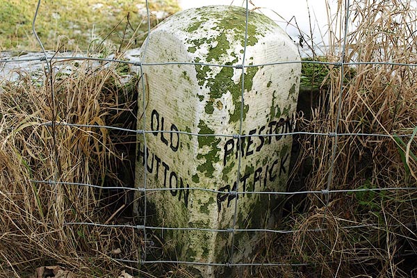
Old Hutton

Old Hutton is a village in South Lakeland, Cumbria, England. It is in the civil parish of Old Hutton and Holmescales In the 2001 census the parish had...

Middleshaw, Cumbria

Middleshaw is a hamlet on the B6254 road, near the village of Old Hutton, in the civil parish of Old Hutton and Holmescales, in the South Lakeland district...

Killington Lake Services

Killington Lake Services is a motorway service station on the M6 motorway between Junctions 37 and 36 near Killington Lake in Cumbria, England. It was...

New Hutton

New Hutton is a village and civil parish in South Lakeland, Cumbria, England. At the 2011 Census, it had a population of 348.New Hutton is east of Kendal...

Killington, Cumbria

Killington is a village and civil parish in the South Lakeland district of the county of Cumbria, England. It had a population of 152 in 2001, At the...

Halfpenny, Cumbria

Halfpenny is a hamlet in the civil parish of Stainton, in the South Lakeland district, in the county of Cumbria, England. It is located roughly two and...

Nearby Amenities

Located within 500m of 54.28805,-2.6552734
Power: tower
Source: Bing
Lat/Long: 54.2843126/-2.6529677
Power: tower
Source: Bing
Lat/Long: 54.2862188/-2.6533844
Power: tower
Source: Bing
Lat/Long: 54.2901817/-2.6544084
Power: tower
Source: Bing
Lat/Long: 54.2919151/-2.6589046
Power: pole
Lat/Long: 54.2869776/-2.6485298
Power: pole
Lat/Long: 54.2878761/-2.6497044
Power: pole
Lat/Long: 54.2888401/-2.6509491
Power: pole
Lat/Long: 54.2895093/-2.6517415
Power: pole
Lat/Long: 54.289452/-2.6535051
Power: pole
Lat/Long: 54.2893947/-2.6550058
Barrier: cattle_grid
Lat/Long: 54.2859135/-2.6501609
Man Made: street_cabinet
Lat/Long: 54.2886607/-2.6618877
Power: pole
Lat/Long: 54.2881701/-2.6608254
Man Made: mast
Tower Type: communication
Lat/Long: 54.2881419/-2.6610851
Give Way
Direction: forward
Lat/Long: 54.2883506/-2.6607513
Marker: post
Utility: gas
Lat/Long: 54.2866285/-2.6572342
The data included in this document is from www.openstreetmap.org. The data is made available under ODbL.

Have you been to Brunthwaite Wood?

Leave your review of Brunthwaite Wood below (or comments, questions and feedback).