Conistone
Settlement in Yorkshire Craven
England
Conistone
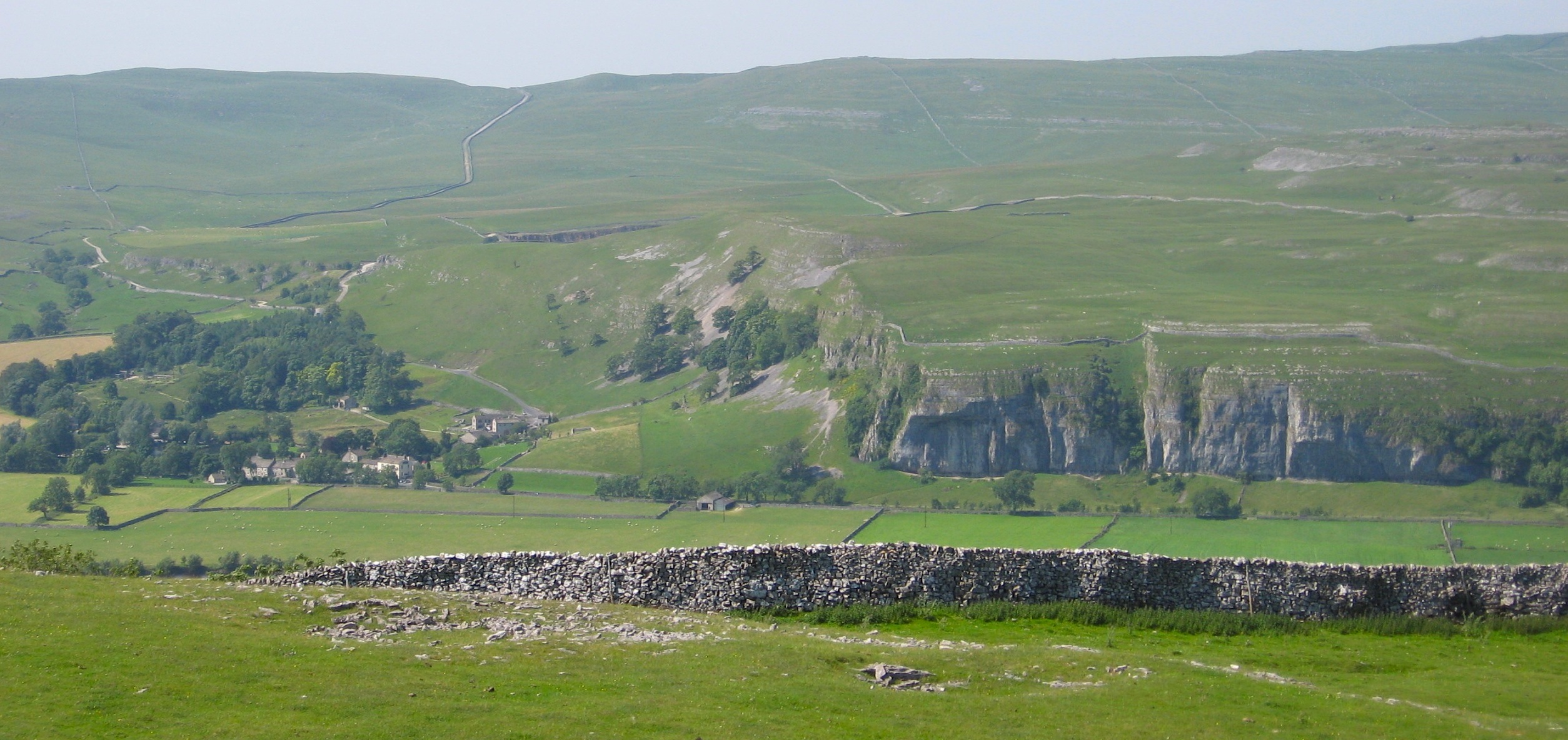
![A walk from Grassington to Kelber and return [46] At this junction of tracks, Bycliffe Road, a public bridleway turns left.
After leaving the town, the walk crosses Grassington Moor via Bare House to Bycliffe Road. The road is followed past Kelber Gate towards Scot Gate Lane. The route then follows the long distance Dales Way back to Grassington. About 6½ miles.](https://s0.geograph.org.uk/geophotos/07/03/78/7037868_95a73232.jpg)
Conistone is a small village located in the Yorkshire Dales National Park in North Yorkshire, England. Situated in the Craven district, it lies approximately 6 miles northwest of the town of Grassington. The village is surrounded by picturesque countryside, boasting stunning views of rolling hills, lush green meadows, and traditional dry-stone walls.
With a population of around 100 residents, Conistone is a close-knit community that exudes a peaceful and tranquil atmosphere. The village is characterized by its charming stone-built houses, many of which date back several centuries, showcasing the area's rich history and architectural heritage.
Conistone is renowned for its natural beauty and serves as an ideal base for exploring the stunning Yorkshire Dales. The village is situated near several popular walking trails, including the famous Dales Way, which attracts hikers and nature enthusiasts from far and wide. The nearby River Wharfe offers opportunities for fishing and paddling, while the surrounding hills provide excellent terrain for cycling and horse riding.
Despite its small size, Conistone is not devoid of amenities. The village is home to a church, St. Mary's, which holds regular services and community events. The neighboring village of Grassington provides additional facilities such as shops, pubs, and a primary school, ensuring that residents have convenient access to essential services.
In summary, Conistone is a charming and idyllic village in the heart of Yorkshire, offering a peaceful retreat for nature lovers and outdoor enthusiasts. Its stunning surroundings, rich history, and sense of community make it a truly special place to visit or call home.
If you have any feedback on the listing, please let us know in the comments section below.
Conistone Images
Images are sourced within 2km of 54.103084/-2.030155 or Grid Reference SD9867. Thanks to Geograph Open Source API. All images are credited.
![A walk from Grassington to Kelber and return [47] A public bridleway runs from behind the camera to this junction and turns left towards Coniston. A public footpath branches off, running straight ahead towards Kettlewell.
After leaving the town, the walk crosses Grassington Moor via Bare House to Bycliffe Road. The road is followed past Kelber Gate towards Scot Gate Lane. The route then follows the long distance Dales Way back to Grassington. About 6½ miles.](https://s1.geograph.org.uk/geophotos/07/03/78/7037869_06c0f74d.jpg)
![A walk from Grassington to Kelber and return [48] From the junction, Bycliffe Road, a public bridleway, heads downhill towards Conistone.
After leaving the town, the walk crosses Grassington Moor via Bare House to Bycliffe Road. The road is followed past Kelber Gate towards Scot Gate Lane. The route then follows the long distance Dales Way back to Grassington. About 6½ miles.](https://s2.geograph.org.uk/geophotos/07/03/78/7037870_30b206dc.jpg)
![A walk from Grassington to Kelber and return [49] A look back along Bycliffe Road from the track junction.
After leaving the town, the walk crosses Grassington Moor via Bare House to Bycliffe Road. The road is followed past Kelber Gate towards Scot Gate Lane. The route then follows the long distance Dales Way back to Grassington. About 6½ miles.](https://s0.geograph.org.uk/geophotos/07/03/78/7037872_78b49e85.jpg)
![A walk from Grassington to Kelber and return [50] Bycliffe Road passes through this gate on its way to Conistone.
After leaving the town, the walk crosses Grassington Moor via Bare House to Bycliffe Road. The road is followed past Kelber Gate towards Scot Gate Lane. The route then follows the long distance Dales Way back to Grassington. About 6½ miles.](https://s1.geograph.org.uk/geophotos/07/03/78/7037873_df01dd3f.jpg)
![A walk from Grassington to Kelber and return [51] Now known as Scot Gate Lane, the track descends steeply between rock outcrops.
After leaving the town, the walk crosses Grassington Moor via Bare House to Bycliffe Road. The road is followed past Kelber Gate towards Scot Gate Lane. The route then follows the long distance Dales Way back to Grassington. About 6½ miles.](https://s3.geograph.org.uk/geophotos/07/03/78/7037875_896b4227.jpg)
![A walk from Grassington to Kelber and return [52] A view of the incised and eroded small valley known as Dib, seen from the track.
After leaving the town, the walk crosses Grassington Moor via Bare House to Bycliffe Road. The road is followed past Kelber Gate towards Scot Gate Lane. The route then follows the long distance Dales Way back to Grassington. About 6½ miles.](https://s0.geograph.org.uk/geophotos/07/03/78/7037876_80188cca.jpg)
![A walk from Grassington to Kelber and return [53] At this point a footpath, part of the long distance Dales Way, crosses the bridleway, Scot Gate Lane.
After leaving the town, the walk crosses Grassington Moor via Bare House to Bycliffe Road. The road is followed past Kelber Gate towards Scot Gate Lane. The route then follows the long distance Dales Way back to Grassington. About 6½ miles.](https://s2.geograph.org.uk/geophotos/07/03/78/7037878_8684a2a0.jpg)
![A walk from Grassington to Kelber and return [54] From the junction, this footpath, part of the long distance Dales Way, heads towards Grassington.
After leaving the town, the walk crosses Grassington Moor via Bare House to Bycliffe Road. The road is followed past Kelber Gate towards Scot Gate Lane. The route then follows the long distance Dales Way back to Grassington. About 6½ miles.](https://s0.geograph.org.uk/geophotos/07/03/78/7037880_65d87271.jpg)
![A walk from Grassington to Kelber and return [55] There is a small stone flag bridge over a rivulet. Just beyond the gate, a footpath branches off to the right to descend into the incised valley known as Dib.
After leaving the town, the walk crosses Grassington Moor via Bare House to Bycliffe Road. The road is followed past Kelber Gate towards Scot Gate Lane. The route then follows the long distance Dales Way back to Grassington. About 6½ miles.](https://s1.geograph.org.uk/geophotos/07/03/78/7037881_13f3d565.jpg)
![A walk from Grassington to Kelber and return [56] A view down the incised valley known as Dib. Seen from the footpath.
After leaving the town, the walk crosses Grassington Moor via Bare House to Bycliffe Road. The road is followed past Kelber Gate towards Scot Gate Lane. The route then follows the long distance Dales Way back to Grassington. About 6½ miles.](https://s2.geograph.org.uk/geophotos/07/03/78/7037882_2711e8ca.jpg)
![A walk from Grassington to Kelber and return [57] The footpath, part of the long distance Dales Way, heads across the moorland towards Grassington.
After leaving the town, the walk crosses Grassington Moor via Bare House to Bycliffe Road. The road is followed past Kelber Gate towards Scot Gate Lane. The route then follows the long distance Dales Way back to Grassington. About 6½ miles.](https://s3.geograph.org.uk/geophotos/07/03/78/7037883_24940df1.jpg)
![A walk from Grassington to Kelber and return [58] Two footpaths cross at this point. The paths lead to Scot Gate Lane, Conistone, Bare House and Grassington.
After leaving the town, the walk crosses Grassington Moor via Bare House to Bycliffe Road. The road is followed past Kelber Gate towards Scot Gate Lane. The route then follows the long distance Dales Way back to Grassington. About 6½ miles.](https://s1.geograph.org.uk/geophotos/07/03/78/7037889_a8e1b32e.jpg)
![A walk from Grassington to Kelber and return [59] Two footpaths cross at this point. The paths lead to Scot Gate Lane, Conistone, Bare House and Grassington. This is the path to Scot Gate Lane.
After leaving the town, the walk crosses Grassington Moor via Bare House to Bycliffe Road. The road is followed past Kelber Gate towards Scot Gate Lane. The route then follows the long distance Dales Way back to Grassington. About 6½ miles.](https://s0.geograph.org.uk/geophotos/07/03/78/7037892_d686b27a.jpg)
![A walk from Grassington to Kelber and return [60] Two footpaths cross at this point. The paths lead to Scot Gate Lane, Conistone, Bare House and Grassington. This is the path to Conistone.
After leaving the town, the walk crosses Grassington Moor via Bare House to Bycliffe Road. The road is followed past Kelber Gate towards Scot Gate Lane. The route then follows the long distance Dales Way back to Grassington. About 6½ miles.](https://s1.geograph.org.uk/geophotos/07/03/78/7037893_52c6e732.jpg)
![A walk from Grassington to Kelber and return [61] Two footpaths cross at this point. The paths lead to Scot Gate Lane, Conistone, Bare House and Grassington. This is the path to Bare House.
After leaving the town, the walk crosses Grassington Moor via Bare House to Bycliffe Road. The road is followed past Kelber Gate towards Scot Gate Lane. The route then follows the long distance Dales Way back to Grassington. About 6½ miles.](https://s2.geograph.org.uk/geophotos/07/03/78/7037894_f8fc142c.jpg)
![A walk from Grassington to Kelber and return [62] Two footpaths cross at this point. The paths lead to Scot Gate Lane, Conistone, Bare House and Grassington. This is the path, part of the long distance Dales Way, towards Grassington.
After leaving the town, the walk crosses Grassington Moor via Bare House to Bycliffe Road. The road is followed past Kelber Gate towards Scot Gate Lane. The route then follows the long distance Dales Way back to Grassington. About 6½ miles.](https://s3.geograph.org.uk/geophotos/07/03/78/7037895_d67962c5.jpg)
![A walk from Grassington to Kelber and return [63] At this high gated stile, a red navigation marker has been added.
After leaving the town, the walk crosses Grassington Moor via Bare House to Bycliffe Road. The road is followed past Kelber Gate towards Scot Gate Lane. The route then follows the long distance Dales Way back to Grassington. About 6½ miles.](https://s0.geograph.org.uk/geophotos/07/03/78/7037896_93088696.jpg)
Conistone is located at Grid Ref: SD9867 (Lat: 54.103084, Lng: -2.030155)
Division: West Riding
Administrative County: North Yorkshire
District: Craven
Police Authority: North Yorkshire
What 3 Words
///interlude.airstrip.dupe. Near Grassington, North Yorkshire
Nearby Locations
Related Wikis

Conistone
Conistone is a small village in the Craven district of North Yorkshire, England. It lies 3 miles (5 km) north of Grassington, 3 miles (5 km) south of Kettlewell...

Conistone with Kilnsey
Conistone with Kilnsey is a civil parish in Wharfedale in the district of Craven, North Yorkshire, England. It contains the villages of Kilnsey and Conistone...

St Mary's Church, Conistone
St Mary's Church is in the village of Conistone, North Yorkshire, England. It is an active Anglican parish church in the deanery of Skipton, the archdeaconry...
Kilnsey
Kilnsey is a small village in Wharfedale, North Yorkshire, England. It lies on the B6160 road, between the villages of Grassington and Kettlewell, near...
Nearby Amenities
Located within 500m of 54.103084,-2.030155Have you been to Conistone?
Leave your review of Conistone below (or comments, questions and feedback).