Congerstone

Settlement in Leicestershire Hinckley and Bosworth

England

Congerstone

Carlton Bridge, Ashby Canal Bridge 44 is about half a mile west of Carlton village surrounded by peaceful countryside.
Carlton Bridge, Ashby Canal Credit: Stephen McKay

Congerstone is a small village located in the county of Leicestershire, England. Situated approximately 11 miles west of Leicester, it falls within the Hinckley and Bosworth district. The village is surrounded by picturesque countryside, offering a tranquil and rural setting.

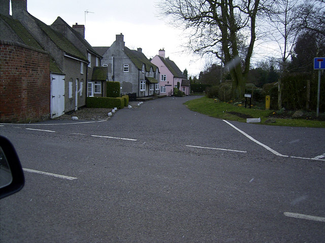
Congerstone is known for its rich history, with evidence of human activity in the area dating back to the Roman period. The village itself has a charming and traditional feel, with a mix of old and new buildings. The centerpiece of Congerstone is the All Saints Church, a beautiful 13th-century structure that stands as a testament to the village's long-standing presence.

Despite its small size, Congerstone offers a range of amenities for its residents. The village has a primary school, providing education for local children. Additionally, there is a post office and a village shop that cater to the daily needs of the community.

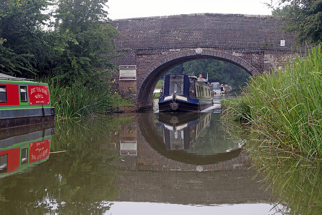
The surrounding area offers ample opportunities for outdoor activities and exploration. The nearby Ashby Woulds Heritage Trail provides a scenic route for walkers and cyclists, offering stunning views of the local countryside. The Ashby Canal also passes through Congerstone, providing opportunities for boating and fishing enthusiasts.

Overall, Congerstone is a peaceful and idyllic village that provides a close-knit community, a rich history, and a picturesque setting for its residents and visitors.

If you have any feedback on the listing, please let us know in the comments section below.

Congerstone Images

Images are sourced within 2km of 52.644161/-1.455342 or Grid Reference SK3605. Thanks to Geograph Open Source API. All images are credited.

Carlton Bridge, Ashby Canal Bridge 44 is about half a mile west of Carlton village surrounded by peaceful countryside.
Carlton Bridge, Ashby Canal
Bridge 44 is about half a mile west of Carlton village surrounded by peaceful countryside.
Carlton Bridge, Ashby Canal The northern stretch of the Ashby Canal, from here at bridge 44 to the end at Snarestone, is designated a Site of Special Scientific Interest (SSSI). Users are advised of this by the blue Canal & River trust sign. The SSSI covers just over six miles of waterway and is designated because of the diversity of aquatic plants and insect life. Nine species of dragonfly have been recorded here.
Carlton Bridge, Ashby Canal
The northern stretch of the Ashby Canal, from here at bridge 44 to the end at Snarestone, is designated a Site of Special Scientific Interest (SSSI). Users are advised of this by the blue Canal & River trust sign. The SSSI covers just over six miles of waterway and is designated because of the diversity of aquatic plants and insect life. Nine species of dragonfly have been recorded here.
Ashby Canal from Carlton Bridge The light is beginning to fade on a summer evening where the Ashby Canal curls through the Leicestershire countryside west of Carlton.
Ashby Canal from Carlton Bridge
The light is beginning to fade on a summer evening where the Ashby Canal curls through the Leicestershire countryside west of Carlton.
Ashby Canal, near Carlton Seen in the evening light, a line of narrowboats is moored on this stretch of the Ashby Canal just round the bend from Carlton Bridge.
Ashby Canal, near Carlton
Seen in the evening light, a line of narrowboats is moored on this stretch of the Ashby Canal just round the bend from Carlton Bridge.
Fairfield Bridge, Ashby Canal Bridge 46 on the canal carries a track leading south from Bosworth Road to Robies Gorse Farm.
Fairfield Bridge, Ashby Canal
Bridge 46 on the canal carries a track leading south from Bosworth Road to Robies Gorse Farm.
Approaching Congerstone Bridge, Ashby Canal A member of the Rose Narrowboats hire fleet is moored on the bend approaching Congerston Bridge, no 47 on the canal (counting up from Marston Junction).
Approaching Congerstone Bridge, Ashby Canal
A member of the Rose Narrowboats hire fleet is moored on the bend approaching Congerston Bridge, no 47 on the canal (counting up from Marston Junction).
Dakins Bridge, Ashby Canal Dakins Bridge, no 48 on the Ashby Canal, is a farm accommodation bridge just to the east of Congerstone village.
Dakins Bridge, Ashby Canal
Dakins Bridge, no 48 on the Ashby Canal, is a farm accommodation bridge just to the east of Congerstone village.
Terrace Bridge, Ashby Canal Terrace Bridge, no 49 on the Ashby Canal, carries a track which is a continuation of Poplar Terrace.
Terrace Bridge, Ashby Canal
Terrace Bridge, no 49 on the Ashby Canal, carries a track which is a continuation of Poplar Terrace.
Bates Bridge, Ashby Canal Bates Bridge, no 50 on the Ashby Canal, is one of two with the Bates name - the other being bridge 51, Bates Wharf Bridge, slightly further north.
Bates Bridge, Ashby Canal
Bates Bridge, no 50 on the Ashby Canal, is one of two with the Bates name - the other being bridge 51, Bates Wharf Bridge, slightly further north.
Bates Wharf Bridge, Ashby Canal Bates Wharf Bridge, no 51 on the Ashby Canal, carries Barton Lane (the road from Congerstone to Barton in the Beans). The sign on the parapet advertises the Rising Sun at Shackerstone.
Bates Wharf Bridge, Ashby Canal
Bates Wharf Bridge, no 51 on the Ashby Canal, carries Barton Lane (the road from Congerstone to Barton in the Beans). The sign on the parapet advertises the Rising Sun at Shackerstone.
Turn Bridge, Ashby Canal Bridge 52 is at the eastern end of Shackerstone village and the red sign advertises the nearby Rising Sun pub. Here the towpath changes side; having been on the western side of the canal from Marston Junction it continues on the eastern side to the end of navigation at Snarestone.
Turn Bridge, Ashby Canal
Bridge 52 is at the eastern end of Shackerstone village and the red sign advertises the nearby Rising Sun pub. Here the towpath changes side; having been on the western side of the canal from Marston Junction it continues on the eastern side to the end of navigation at Snarestone.
Town Bridge, Ashby Canal A narrowboat heads through bridge no 53 at the northern end of Shackerstone village. The red and green boat on the left is called, cryptically, 'Just the Same'.
Town Bridge, Ashby Canal
A narrowboat heads through bridge no 53 at the northern end of Shackerstone village. The red and green boat on the left is called, cryptically, 'Just the Same'.
Ashby Canal, Shackerstone An early evening view along the Ashby Canal from Turn Bridge. Wharf Farm is on the left.
Ashby Canal, Shackerstone
An early evening view along the Ashby Canal from Turn Bridge. Wharf Farm is on the left.
Shackerstone Station - footbridge The footbridge at Shackerstone - at the northern end of the Battlefield Line - is actually part of a footpath and does not give access to railway infrastructure.
Shackerstone Station - footbridge
The footbridge at Shackerstone - at the northern end of the Battlefield Line - is actually part of a footpath and does not give access to railway infrastructure.
Shackerstone Railway Station Heritage Battlefield Line Railway.
Shackerstone Railway Station
Heritage Battlefield Line Railway.
Shackerstone Station Throat On the heritage Battlefield Line
Shackerstone Station Throat
On the heritage Battlefield Line
Railway bridge carrying the Battlefield Line. The Battlefield Line is a heritage railway using the route that was once jointly operated by the London and North Western Railway, and the Midland Railway.
The road is west of the village of Carlton and must be subject to flooding; there's a flood 'ruler' at the depression beneath the bridge indicating a possible water depth above six feet!
Railway bridge carrying the Battlefield Line.
The Battlefield Line is a heritage railway using the route that was once jointly operated by the London and North Western Railway, and the Midland Railway. The road is west of the village of Carlton and must be subject to flooding; there's a flood 'ruler' at the depression beneath the bridge indicating a possible water depth above six feet!
Working Narrow Boat Hadar moored at Shackerstone Working Narrow Boat Hadar moored at Shackerstone, November 2011, photo taken from Battlefield Line Railway Shackerstone station approach road.
Working Narrow Boat Hadar moored at Shackerstone
Working Narrow Boat Hadar moored at Shackerstone, November 2011, photo taken from Battlefield Line Railway Shackerstone station approach road.
Show me another place!

Congerstone is located at Grid Ref: SK3605 (Lat: 52.644161, Lng: -1.455342)

Administrative County: Leicestershire

District: Hinckley and Bosworth

Police Authority: Leicestershire

What 3 Words

///forgives.others.beard. Near Market Bosworth, Leicestershire

Nearby Locations

Congerstone Bilstone

Related Wikis

Congerstone

Congerstone () is a village and former civil parish, now in the parish of Shackerstone, in the Hinckley and Bosworth district, in Leicestershire, England...

Bilstone

Bilstone is a small village and former civil parish, now in the parish of Shackerstone, in the Hinckley and Bosworth district of Leicestershire, England...

Shackerstone railway station

Shackerstone railway station is a preserved railway station and heritage museum in Leicestershire, Central England. It is the terminus and the headquarters...

Shackerstone

Shackerstone is a village and civil parish in the Hinckley and Bosworth district of Leicestershire, England. It is situated on the Ashby-de-la-Zouch Canal...

Odstone

Odstone is a hamlet and former civil parish, now in the parish of Shackerstone, in the Hinckley and Bosworth district of Leicestershire, England. It stands...

Barton in the Beans

Barton in the Beans is a hamlet and former civil parish, now in the parish of Shackerstone, in the Hinckley and Bosworth district of Leicestershire, England...

Carlton, Leicestershire

Carlton is a small rural parish located East of the river Sence in Leicestershire, England, around 2.2 miles North of Market Bosworth. According to the...

Gopsall

Gopsall is a former civil parish, now in the parish of Twycross, in the Hinckley and Bosworth district, in the county of Leicestershire, England. It is...

Nearby Amenities

Located within 500m of 52.644161,-1.455342
Congerstone
Is In Country: UK
Is In County: Leicestershire
Place: village
Wikidata: Q5160463
Lat/Long: 52.6441487/-1.4568242
Bus Stop
Main Street
Alt Name: Congerstone - Main Street
Bus: yes
Naptan AltCommonName: Congerstone - Main Street
Naptan AtcoCode: 260011701
Naptan Bearing: S
Naptan CommonName: Main Street
Naptan Indicator: junction
Naptan Landmark: Barton Road
Naptan NaptanCode: leijdgpg
Naptan Notes: Non-Hourly - County
Naptan Street: Main Street
Naptan Verified: no
Public Transport: platform
Shelter: yes
Source: naptan_import
Lat/Long: 52.6456544/-1.4573341
Bus Stop
Horse & Jockey PH
Bus: yes
Naptan AtcoCode: 260011705
Naptan Bearing: N
Naptan BusStopType: CUS
Naptan CommonName: Horse & Jockey PH
Naptan Indicator: outside
Naptan Landmark: Horse & Jockey
Naptan NaptanCode: leijdgpw
Naptan Notes: Non-Hourly - County
Naptan Street: Main Street
Naptan Verified: no
Public Transport: platform
Source: naptan_import
Lat/Long: 52.6426976/-1.4572614
Bus Stop
Main Street
Bus: yes
Naptan AtcoCode: 260080071
Naptan Bearing: N
Naptan BusStopType: CUS
Naptan CommonName: Main Street
Naptan Indicator: outside
Naptan Landmark: War Memorial
Naptan NaptanCode: leijwtpg
Naptan Notes: Non-Hourly - County
Naptan Street: Main Street
Naptan Verified: no
Public Transport: platform
Source: naptan_import
Lat/Long: 52.645407/-1.4574239
Bus Stop
Horse & Jockey PH
Bus: yes
Naptan AtcoCode: 260011706
Naptan Bearing: S
Naptan BusStopType: CUS
Naptan CommonName: Horse & Jockey PH
Naptan Indicator: opposite
Naptan Landmark: Horse & Jockey
Naptan NaptanCode: leijdgta
Naptan Notes: Non-Hourly - County
Naptan Street: Main Street
Naptan Verified: no
Public Transport: platform
Source: naptan_import
Lat/Long: 52.642743/-1.4570747
Telephone
Booth: K6
Covered: booth
Phone: +44 1827 880218
Lat/Long: 52.6456942/-1.4573417
Post Box
Collection Times: Mo-Fr 09:00; Sa 07:00
Drive Through: no
Operator: Royal Mail
Post Box Mounting: metal_post
Post Box Type: lamp
Ref: CV13 63D
Royal Cypher: EIIR
Royal Cypher Wikidata: Q33102113
Source: survey
Lat/Long: 52.6456855/-1.4573042
Bench
Lat/Long: 52.6456098/-1.4572801
Historic: cross
Lat/Long: 52.6454511/-1.4572613
The data included in this document is from www.openstreetmap.org. The data is made available under ODbL.

Have you been to Congerstone?

Leave your review of Congerstone below (or comments, questions and feedback).