Lodge Wood

Wood, Forest in Lancashire

England

Lodge Wood

St Paul of the Cross Roman Catholic Church Built 2001. Architects Cassidy & Ashton.
St Paul of the Cross Roman Catholic Church Credit: S Parish

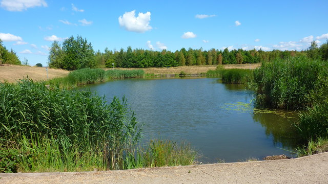
Lodge Wood, located in the county of Lancashire, England, is a peaceful and picturesque forest area that offers a tranquil escape from the bustling city life. Spanning over several acres, this woodland is a popular destination for nature enthusiasts and those seeking a serene environment.

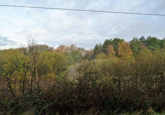
The forest is predominantly made up of a variety of deciduous and evergreen trees, including oak, beech, and birch, which create a dense canopy overhead. This lush vegetation provides a habitat for a diverse range of wildlife, including birds, squirrels, and deer, making it a haven for nature lovers and wildlife photographers.

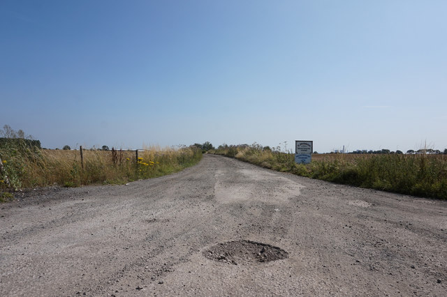
Lodge Wood boasts a network of well-maintained walking trails and paths that meander through the forest. These trails cater to different levels of difficulty, allowing visitors to explore the area at their own pace and experience the beauty of the woodland up close. The serene atmosphere and the sound of birds chirping make it an ideal spot for a peaceful stroll or a family picnic.

Additionally, the woodland is home to a small lake, offering visitors the opportunity to engage in fishing or simply relax by the water's edge. Anglers can try their luck at catching various species of fish, including perch, roach, and pike.

Lodge Wood is conveniently located near several towns and villages, making it easily accessible for both locals and tourists. Its natural beauty, tranquil ambiance, and diverse wildlife make it a highly sought-after destination for those seeking a rejuvenating escape in the heart of Lancashire.

If you have any feedback on the listing, please let us know in the comments section below.

Lodge Wood Images

Images are sourced within 2km of 53.425148/-2.6817286 or Grid Reference SJ5492. Thanks to Geograph Open Source API. All images are credited.

St Paul of the Cross Roman Catholic Church Built 2001. Architects Cassidy & Ashton.
St Paul of the Cross Roman Catholic Church
Built 2001. Architects Cassidy & Ashton.
Track and woodland, Sutton Moss
Clay Lane Passing Burtonwood Triangulation Pillar Looking northward.
Clay Lane Passing Burtonwood Triangulation Pillar
Looking northward.
St Helens Junction Station
St. Helens Junction railway station Opened in 1831 by the Liverpool & Manchester Railway, later part of the London & North Western Railway.
View east towards Collins Green and Manchester, shortly after electrification. For a similar view six years earlier, see <a href="https://www.geograph.org.uk/photo/3444129">SJ5393 : St. Helens Junction railway station</a>.
There used to be a further bay platform to the right and another to the far left. The junction was behind the photographer and connected this line with St Helens.
St. Helens Junction railway station
Opened in 1831 by the Liverpool & Manchester Railway, later part of the London & North Western Railway. View east towards Collins Green and Manchester, shortly after electrification. For a similar view six years earlier, see SJ5393 : St. Helens Junction railway station. There used to be a further bay platform to the right and another to the far left. The junction was behind the photographer and connected this line with St Helens.
Pond in Clock Face Colliery Country Park
Path in Clock Face Colliery Country Park Fiddler's Ferry power station is visible in the distance.
Path in Clock Face Colliery Country Park
Fiddler's Ferry power station is visible in the distance.
The Vulcan Traditional public house on Robins Lane.
The Vulcan
Traditional public house on Robins Lane.
The Church of All Saints, Ellamsbridge Road All Saints’ Church at Sutton is an Anglican parish church built between 1891 and 1893. It is a Grade II listed building (Historic England List Entry Number: 1260566 <span class="nowrap"><a title="https://historicengland.org.uk/listing/the-list/list-entry/1260566" rel="nofollow ugc noopener" href="https://historicengland.org.uk/listing/the-list/list-entry/1260566">Link</a><img style="margin-left:2px;" alt="External link" title="External link - shift click to open in new window" src="https://s1.geograph.org.uk/img/external.png" width="10" height="10"/></span>  ).
The Church of All Saints, Ellamsbridge Road
All Saints’ Church at Sutton is an Anglican parish church built between 1891 and 1893. It is a Grade II listed building (Historic England List Entry Number: 1260566 LinkExternal link ).
The Boilermaker's Arms Public house at the corner of Houghton Road and Cecil Street.
The Boilermaker's Arms
Public house at the corner of Houghton Road and Cecil Street.
Houses on Clay Lane at Haley Road North
Chapel House, Chapel Lane, Burtonwood
Entrance to Moathouse Farm
Frenchfields Crescent off Gorsey Lane
Gorsey Lane, Clock Face
Old Moat House Dramatic sky over Old Moat House, seen from Gorsey Lane.
Old Moat House
Dramatic sky over Old Moat House, seen from Gorsey Lane.
Ivy Cottage Dramatic sky over Ivy Cottage Farm, seen from Clay Lane.
Ivy Cottage
Dramatic sky over Ivy Cottage Farm, seen from Clay Lane.
Show me another place!

Lodge Wood is located at Grid Ref: SJ5492 (Lat: 53.425148, Lng: -2.6817286)

Unitary Authority: St. Helens

Police Authority: Merseyside

What 3 Words

///bandwagon.locate.slice. Near Burtonwood, Cheshire

Nearby Locations

Lodge Wood

Related Wikis

Bold, St Helens

Bold is a civil parish in the Metropolitan Borough of St Helens in Merseyside, England. Bold itself is situated to the south east of St Helens, near to...
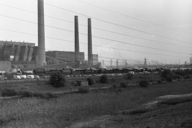
Bold Power Station

Bold Power Station refers to a series of two coal-fired power stations in Bold near St Helens, Merseyside, North West England. They were closed, decommissioned...

Burtonwood

Burtonwood is a village in the civil parish of Burtonwood and Westbrook, in the Borough of Warrington, Cheshire, England. Within the boundaries of the...

Hoghton Road Stadium

Hoghton Road Stadium was a sports stadium on Hoghton Road, Sutton, a suburb of St. Helens (population approx 100,000), the administrative centre of the...

Nearby Amenities

Located within 500m of 53.425148,-2.6817286
Bus Stop
NEILLS RD/BOLD IRON WORKS
Bus: yes
Naptan AtcoCode: 2800S13114A
Naptan Bearing: N
Naptan CommonName: NEILLS RD/BOLD IRON WORKS
Naptan Indicator: NEILLS ROAD/BOLD IRON WORKS
Naptan Landmark: O/S 41-43
Naptan NaptanCode: meragjam
Naptan Notes: No Notes
Naptan ShortCommonName: Neills Road
Naptan Street: NEILLS ROAD
Naptan Verified: no
Public Transport: platform
Source: naptan_import
Lat/Long: 53.4282989/-2.6830413
Bus Stop
NEILLS RD/BOLD IRON WORKS
Bus: yes
Naptan AtcoCode: 2800S13114B
Naptan Bearing: S
Naptan CommonName: NEILLS RD/BOLD IRON WORKS
Naptan Indicator: NEILLS ROAD/DOUGLAS DRIVE/BOLD IRON WORKS
Naptan Landmark: OPP 37
Naptan NaptanCode: meragjap
Naptan Notes: No Notes
Naptan ShortCommonName: Iron Works
Naptan Street: NEILLS ROAD
Naptan Verified: no
Public Transport: platform
Source: naptan_import
Lat/Long: 53.4280927/-2.6829477
Bus Stop
GORSEY LANE
Bench: no
Bin: no
Bus: yes
Naptan AtcoCode: 2800S13185A
Naptan Bearing: W
Naptan CommonName: GORSEY LANE
Naptan Indicator: GORSEY LANE/NEILS ROAD
Naptan Landmark: OPP WHEATACRE COTTAGE
Naptan NaptanCode: meragmda
Naptan Notes: No Notes
Naptan ShortCommonName: Gorsey Ln
Naptan Street: GORSEY LANE
Naptan Verified: no
Public Transport: platform
Shelter: no
Source: naptan_import
Tactile Paving: no
Lat/Long: 53.4275305/-2.6759103
Bus Stop
GORSEY LANE
Bench: no
Bin: no
Bus: yes
Naptan AtcoCode: 2800S13185B
Naptan Bearing: E
Naptan CommonName: GORSEY LANE
Naptan Indicator: GORSEY LANE/NEILS ROAD
Naptan Landmark: O/S WHEATACRE COTTAGE
Naptan NaptanCode: meragmdg
Naptan Notes: No Notes
Naptan ShortCommonName: Gorsey Ln
Naptan Street: GORSEY LANE
Naptan Verified: no
Public Transport: platform
Shelter: no
Source: naptan_import
Tactile Paving: no
Lat/Long: 53.4275276/-2.6764219
Bold
Place: suburb
Lat/Long: 53.4276049/-2.6845489
Power: pole
Lat/Long: 53.4260607/-2.6886839
Power: pole
Lat/Long: 53.4252263/-2.6890924
Post Box
Operator: Royal Mail
Operator Wikidata: Q638098
Post Box Type: lamp
Ref: WA9 21
Royal Cypher: EIIR
Lat/Long: 53.4279213/-2.6831888
Give Way
Direction: forward
Lat/Long: 53.4261954/-2.6832237
The data included in this document is from www.openstreetmap.org. The data is made available under ODbL.

Have you been to Lodge Wood?

Leave your review of Lodge Wood below (or comments, questions and feedback).