Farington Hall Wood

Wood, Forest in Lancashire South Ribble

England

Farington Hall Wood

Matrix board - northbound M6
Matrix board - northbound M6 Credit: Dave Thompson

Farington Hall Wood is a picturesque woodland located in Lancashire, England. Situated near the village of Farington, it covers an area of approximately 10 hectares. The woodland is a popular destination for nature enthusiasts and those seeking a peaceful retreat.

The wood is characterized by a diverse range of tree species, including oak, birch, and beech, which create a rich and vibrant canopy. This variety of trees provides a habitat for numerous wildlife species, such as squirrels, birds, and deer. The wood is also home to a variety of plant species, including bluebells and wild garlic, which create a stunning display during the spring season.

Visitors to Farington Hall Wood can enjoy several walking trails that wind through the forest, allowing them to explore its natural beauty. The wood is well-maintained, with clear paths and signage, making it easily accessible for people of all ages and abilities. Along the trails, there are benches and picnic areas where visitors can rest and take in the tranquil surroundings.

The wood also has a rich historical background, with remnants of Farington Hall, a former manor house, still visible within its grounds. This adds a touch of intrigue and nostalgia to the woodland, allowing visitors to connect with the area's past.

Overall, Farington Hall Wood offers a serene and enchanting natural experience, with its scenic beauty, diverse wildlife, and historical significance. It is a place where visitors can escape the hustle and bustle of everyday life and immerse themselves in the wonders of nature.

If you have any feedback on the listing, please let us know in the comments section below.

Farington Hall Wood Images

Images are sourced within 2km of 53.702926/-2.699254 or Grid Reference SD5323. Thanks to Geograph Open Source API. All images are credited.
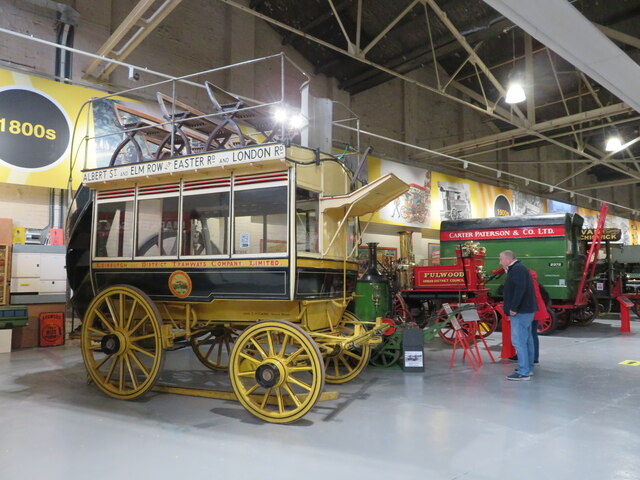
Matrix board - northbound M6
Footbridge - northbound M6
Leyland Railway Station
British Commercial Vehicle Museum, Leyland The car park and entrance to this most excellent museum. It has had a face-lift since Roger Cornfoot was there in 2015 - <a href="https://www.geograph.org.uk/photo/4529223">SD5422 : The British Commercial Vehicle Museum, Leyland</a>
British Commercial Vehicle Museum, Leyland
The car park and entrance to this most excellent museum. It has had a face-lift since Roger Cornfoot was there in 2015 - SD5422 : The British Commercial Vehicle Museum, Leyland
19th Century horse-drawn bus Originally from the Edinburgh and District Tramways Company Limited, now at the Leyland Commercial Vehicles Museum. For a rear view see <a href="https://www.geograph.org.uk/photo/7006065">SD5422 : 19th Century horse-drawn bus</a>
19th Century horse-drawn bus
Originally from the Edinburgh and District Tramways Company Limited, now at the Leyland Commercial Vehicles Museum. For a rear view see SD5422 : 19th Century horse-drawn bus
19th Century horse-drawn bus Originally from the Edinburgh and District Tramways Company Limited, now at the Leyland Commercial Vehicles Museum. For a side view see <a href="https://www.geograph.org.uk/photo/7006059">SD5422 : 19th Century horse-drawn bus</a>

FARE 
BUS & CAR 3d 
BUS 1d

For the younger amongst us 3d = 1.25p, and 1d = 0.416p
19th Century horse-drawn bus
Originally from the Edinburgh and District Tramways Company Limited, now at the Leyland Commercial Vehicles Museum. For a side view see SD5422 : 19th Century horse-drawn bus FARE BUS & CAR 3d BUS 1d For the younger amongst us 3d = 1.25p, and 1d = 0.416p
The Edinburgh & District Tramways Company Limited The company's logo on the horse tram at the British Commercial Vehicle Museum <a href="https://www.geograph.org.uk/photo/7006059">SD5422 : 19th Century horse-drawn bus</a>. It operated from 1893 to 1919 <span class="nowrap"><a title="https://en.wikipedia.org/wiki/Edinburgh_and_District_Tramways" rel="nofollow ugc noopener" href="https://en.wikipedia.org/wiki/Edinburgh_and_District_Tramways">Link</a><img style="margin-left:2px;" alt="External link" title="External link - shift click to open in new window" src="https://s1.geograph.org.uk/img/external.png" width="10" height="10"/></span>.
The Edinburgh & District Tramways Company Limited
The company's logo on the horse tram at the British Commercial Vehicle Museum SD5422 : 19th Century horse-drawn bus. It operated from 1893 to 1919 LinkExternal link.
Television Detector Van A 1979 Dodge Space Van that served as a TV licence detector van, in the British Commercial Vehicle Museum. The vehicle on the left is a 1927 Model T Ford van - see <a href="https://www.geograph.org.uk/photo/7006155">SD5422 : Ford 'Model T'</a> for details.
Television Detector Van
A 1979 Dodge Space Van that served as a TV licence detector van, in the British Commercial Vehicle Museum. The vehicle on the left is a 1927 Model T Ford van - see SD5422 : Ford 'Model T' for details.
Ford 'Model T' Details of the Ford van at the British Commercial Vehicle Museum <a href="https://www.geograph.org.uk/photo/7006143">SD5422 : Television Detector Van</a>.
Ford 'Model T'
Details of the Ford van at the British Commercial Vehicle Museum SD5422 : Television Detector Van.
Post Office Radio Service Van A 1949 Leyland Morris 'Y' Type van in the British Commercial Vehicle Museum. For details see <a href="https://www.geograph.org.uk/photo/7006164">SD5422 : Leyland Morris 'Y' Type van - details</a>. This one has a trailer attached.
Post Office Radio Service Van
A 1949 Leyland Morris 'Y' Type van in the British Commercial Vehicle Museum. For details see SD5422 : Leyland Morris 'Y' Type van - details. This one has a trailer attached.
Leyland Morris 'Y' Type van - details Details of the van at <a href="https://www.geograph.org.uk/photo/7006161">SD5422 : Post Office Radio Service Van</a>.
Leyland Morris 'Y' Type van - details
Steam Lawnmower, 1896 Built by James Sumner in the early 1890s this was the beginning of a thriving business, Lancashire Steam Motors Co., that became Leyland Motors. This is a replica, from an original belonging to Repton College, with an original engine re-built by Leyland Apprentices. I wonder how many kg of coal and litres of water it would use per 100 sq. m., and if it would be ULEZ/COP26 compliant?
Steam Lawnmower, 1896
Built by James Sumner in the early 1890s this was the beginning of a thriving business, Lancashire Steam Motors Co., that became Leyland Motors. This is a replica, from an original belonging to Repton College, with an original engine re-built by Leyland Apprentices. I wonder how many kg of coal and litres of water it would use per 100 sq. m., and if it would be ULEZ/COP26 compliant?
A showman's engine, Fowler no. 10318 Built in March 1905 for W.H. Marshall & Sons of Bradford. The engine is named Sunny Boy 2 and carries the registration WR 6790. Now in the British Commercial Vehicle Museum. For another view see <a href="https://www.geograph.org.uk/photo/7006209">SD5422 : A showman's engine, Fowler no. 10318,</a>.
A showman's engine, Fowler no. 10318
Built in March 1905 for W.H. Marshall & Sons of Bradford. The engine is named Sunny Boy 2 and carries the registration WR 6790. Now in the British Commercial Vehicle Museum. For another view see SD5422 : A showman's engine, Fowler no. 10318,.
A showman's engine, Fowler no. 10318, 'SUNNY BOY No.2' at the British Commercial Vehicle Museum. For another view see <a href="https://www.geograph.org.uk/photo/7006202">SD5422 : A showman's engine, Fowler no. 10318</a>, and a closer view of the wheel <a href="https://www.geograph.org.uk/photo/7006211">SD5422 : A showman's engine, Fowler no. 10318,</a>.
A showman's engine, Fowler no. 10318,
'SUNNY BOY No.2' at the British Commercial Vehicle Museum. For another view see SD5422 : A showman's engine, Fowler no. 10318, and a closer view of the wheel SD5422 : A showman's engine, Fowler no. 10318,.
A showman's engine, Fowler no. 10318, A close-up of the main driving wheel of <a href="https://www.geograph.org.uk/photo/7006202">SD5422 : A showman's engine, Fowler no. 10318</a>.
A showman's engine, Fowler no. 10318,
A close-up of the main driving wheel of SD5422 : A showman's engine, Fowler no. 10318.
Popemobile at Leyland One of two special vehicles built for Pope John Paul II's visit to the UK in 1982. Two were made, Leyland T45, based on the Constructor 6 chassis. See <a href="https://www.geograph.org.uk/photo/7006222">SD5422 : Leyland T45 Popemobile</a> for details.
Popemobile at Leyland
One of two special vehicles built for Pope John Paul II's visit to the UK in 1982. Two were made, Leyland T45, based on the Constructor 6 chassis. See SD5422 : Leyland T45 Popemobile for details.
Leyland T45 Popemobile Information about the vehicles built for the Pope's visit to the UK in 1982 <a href="https://www.geograph.org.uk/photo/7006219">SD5422 : Popemobile at Leyland</a>
Leyland T45 Popemobile
Information about the vehicles built for the Pope's visit to the UK in 1982 SD5422 : Popemobile at Leyland
Early lorry at the British Commercial Vehicle Museum Advertising the 'first overnight service to Covent Garden, London in 1928'. Not sure where from, but the nearest Craig Street, now and on the gb1900 map, is in Peterborough, which is near the rich vegetable producing areas of Cambridgeshire which would have supplied Covent Garden.

Thanks to Chris Gardner, who has made the following comment:-
The 'first overnight service' operated by William Bowker was between Liverpool Docks and Covent Garden Market in 1926, during the General Strike. Having maintained the Bowker company archives as an employee for almost 20 years and, more recently, been commissioned by them to write a book on their history, I have the information to support this. Craig Street was in Blackburn, by the way.

Craig Street does not exist now and has been replaced by a small estate of modern houses that date from 1985-2000. The old Craig Street stretched from SD675271 to SD 677272 [thanks to Tiger, Robin Webster and Albion for additional information].
Early lorry at the British Commercial Vehicle Museum
Advertising the 'first overnight service to Covent Garden, London in 1928'. Not sure where from, but the nearest Craig Street, now and on the gb1900 map, is in Peterborough, which is near the rich vegetable producing areas of Cambridgeshire which would have supplied Covent Garden. Thanks to Chris Gardner, who has made the following comment:- The 'first overnight service' operated by William Bowker was between Liverpool Docks and Covent Garden Market in 1926, during the General Strike. Having maintained the Bowker company archives as an employee for almost 20 years and, more recently, been commissioned by them to write a book on their history, I have the information to support this. Craig Street was in Blackburn, by the way. Craig Street does not exist now and has been replaced by a small estate of modern houses that date from 1985-2000. The old Craig Street stretched from SD675271 to SD 677272 [thanks to Tiger, Robin Webster and Albion for additional information].
Show me another place!

Farington Hall Wood is located at Grid Ref: SD5323 (Lat: 53.702926, Lng: -2.699254)

Administrative County: Lancashire

District: South Ribble

Police Authority: Lancashire

What 3 Words

///rare.truth.until. Near Leyland, Lancashire

Nearby Locations

Farington Hall Wood

Related Wikis

Farington Moss

Farington Moss is a village approximately two miles to the north of Leyland, Lancashire, England. It is a typical English village with one school and one...

South Ribble

South Ribble is a local government district with borough status in Lancashire, England. Its council is based in Leyland. The borough also includes the...

Wellfield Academy

Wellfield Academy (formerly Wellfield High School) is a coeducational secondary school located in Leyland in the English county of Lancashire.Wellfield...

Leyland railway station

Leyland railway station serves the town of Leyland in Lancashire, England. It was formerly "Golden Hill", the name of the street and area in which the...

Nearby Amenities

Located within 500m of 53.702926,-2.699254
Fuel
Morrisons
Brand: Morrisons
Brand Wikidata: Q922344
Brand Wikipedia: en:Morrisons
Fuel GTL Diesel: no
Fuel HGV Diesel: no
Fuel Biodiesel: no
Fuel Biogas: no
Fuel Cng: no
Fuel Diesel: yes
Fuel E10: no
Fuel E85: no
Fuel Electricity: no
Fuel Lpg: yes
Fuel Octane 95: yes
Self Service: yes
Website: https://my.morrisons.com/storefinder/151/leyland
Lat/Long: 53.7004677/-2.6939957
Crossing
Crossing: unmarked
Lat/Long: 53.7066745/-2.698138
Mini Roundabout
Lat/Long: 53.7063357/-2.6985447
Noexit: yes
Lat/Long: 53.7020864/-2.6953251
Mini Roundabout
Lat/Long: 53.7001464/-2.6937577
Access: yes
Barrier: lift_gate
Lat/Long: 53.7067414/-2.6981736
Entrance: yes
Lat/Long: 53.7068547/-2.7029055
Power: tower
Lat/Long: 53.7047916/-2.6970166
Power: tower
Lat/Long: 53.7045705/-2.7010125
Power: tower
Lat/Long: 53.7042466/-2.7060551
Post Box
Indoor: yes
Location: in Morrisons lobby
Operator: Royal Mail
Post Box Type: indoor_pillar
Ref: PR25 3
Royal Cypher: EIIR
Royal Cypher Wikidata: Q33102113
Lat/Long: 53.6994901/-2.6948842
Crossing
Check Date Crossing: 2021-03-04
Crossing: unmarked
Crossing Island: no
Lat/Long: 53.7008887/-2.6955876
Post Box
Collection Times: Mo-Fr 09:00, Sa 07:00
Operator: Royal Mail
Post Box Mounting: brick_pillar
Post Box Type: wall
Ref: PR25 350
Royal Cypher: EIIR
Royal Cypher Wikidata: Q33102113
Lat/Long: 53.7030862/-2.6946002
Bus Stop
Leyland Morrisons
Bench: yes
Bin: yes
Bus: yes
Departures Board: timetable
Lit: yes
Naptan AtcoCode: 2500LAA15972
Naptan Bearing: N
Naptan CommonName: Morrisons
Naptan Indicator: opp
Naptan NaptanCode: lanjtwgw
Public Transport: platform
Ref: lanjtwgw
Shelter: yes
Tactile Paving: no
Lat/Long: 53.6996671/-2.6962005
Bus Stop
Leyland Morrisons
Bench: yes
Bin: yes
Bus: yes
Departures Board: timetable
Lit: yes
Naptan AtcoCode: 2500LAA15973
Naptan Bearing: S
Naptan CommonName: Morrisons
Naptan Indicator: by
Naptan NaptanCode: lanjtwja
Public Transport: platform
Shelter: yes
Tactile Paving: no
Lat/Long: 53.6993238/-2.6961352
Give Way
Direction: forward
Lat/Long: 53.7062936/-2.694333
Give Way
Direction: backward
Lat/Long: 53.7043047/-2.6944216
Mayoral Bathrooms
Addr City: Leyland
Addr Housenumber: 22
Addr Postcode: PR25 2DY
Addr Street: Tomlinson Road
Email: info@mayoralbathrooms.com
Phone: +44 1772 455 255
Shop: bathroom_furnishing
Website: https://www.mayoralbathrooms.com/
Lat/Long: 53.7005947/-2.70325
Barrier: bollard
Lat/Long: 53.7018571/-2.6995539
Crossing
Crossing: unmarked
Lat/Long: 53.7017693/-2.6950528
Waste Basket
Waste: dog_excrement
Lat/Long: 53.7030168/-2.6944005
Direction: both
Traffic Calming: hump
Lat/Long: 53.7024989/-2.6946917
Direction: both
Traffic Calming: hump
Lat/Long: 53.7022568/-2.6948367
Traffic Calming: yes
Lat/Long: 53.7020117/-2.6949908
Traffic Calming: yes
Lat/Long: 53.70161/-2.6952486
Bus Stop
Parish Gardens
Bench: no
Bus: yes
Naptan AtcoCode: 2500LAA15974
Naptan Bearing: S
Naptan CommonName: Parish Gardens
Naptan Indicator: opp
Naptan NaptanCode: lanjtwjd
Public Transport: platform
Shelter: no
Tactile Paving: yes
Lat/Long: 53.7008063/-2.6955382
Crossing
Lat/Long: 53.7072654/-2.6985378
Generator Method: photovoltaic
Generator Output Electricity: yes
Generator Source: solar
Generator Type: solar_photovoltaic_panel
Location: roof
Power: generator
Lat/Long: 53.7029692/-2.7032281
Generator Method: photovoltaic
Generator Output Electricity: yes
Generator Source: solar
Generator Type: solar_photovoltaic_panel
Location: roof
Power: generator
Lat/Long: 53.7031542/-2.7032429
Generator Method: photovoltaic
Generator Output Electricity: yes
Generator Source: solar
Generator Type: solar_photovoltaic_panel
Location: roof
Power: generator
Lat/Long: 53.703336/-2.7018723
Generator Method: photovoltaic
Generator Output Electricity: yes
Generator Source: solar
Generator Type: solar_photovoltaic_panel
Location: roof
Power: generator
Lat/Long: 53.7034027/-2.7018267
Generator Method: photovoltaic
Generator Output Electricity: yes
Generator Source: solar
Generator Type: solar_photovoltaic_panel
Location: roof
Power: generator
Lat/Long: 53.702762/-2.7013949
Generator Method: photovoltaic
Generator Output Electricity: yes
Generator Source: solar
Generator Type: solar_photovoltaic_panel
Location: roof
Power: generator
Lat/Long: 53.7027469/-2.7019729
Generator Method: photovoltaic
Generator Output Electricity: yes
Generator Source: solar
Generator Type: solar_photovoltaic_panel
Location: roof
Power: generator
Lat/Long: 53.7027477/-2.701938
Generator Method: photovoltaic
Generator Output Electricity: yes
Generator Source: solar
Generator Type: solar_photovoltaic_panel
Location: roof
Power: generator
Lat/Long: 53.7029938/-2.7018133
Generator Method: photovoltaic
Generator Output Electricity: yes
Generator Source: solar
Generator Type: solar_photovoltaic_panel
Location: roof
Power: generator
Lat/Long: 53.7016009/-2.7010536
Generator Method: photovoltaic
Generator Output Electricity: yes
Generator Source: solar
Generator Type: solar_photovoltaic_panel
Location: roof
Power: generator
Lat/Long: 53.70104/-2.6974842
Location: outdoor
Operator: Electricity North West
Power: transformer
Transformer: distribution
Voltage Primary: 132 kVA
Voltage Secondary: 33 kVA
Lat/Long: 53.7049843/-2.696897
Location: outdoor
Operator: Electricity North West
Power: transformer
Transformer: distribution
Voltage Primary: 132 kVA
Voltage Secondary: 33 kVA
Lat/Long: 53.7045913/-2.6968882
Location: outdoor
Operator: Electricity North West
Power: transformer
Transformer: distribution
Voltage Primary: 33 kVA
Voltage Secondary: 11 kVA
Lat/Long: 53.7039421/-2.6930053
Location: outdoor
Operator: Electricity North West
Power: transformer
Transformer: distribution
Voltage Primary: 33 kVA
Voltage Secondary: 11 kVA
Lat/Long: 53.7039215/-2.6931461
Content: LPG
Man Made: storage_tank
Lat/Long: 53.700446/-2.6942971
Content: LPG
Man Made: storage_tank
Lat/Long: 53.7004224/-2.6943041
Content: LPG
Man Made: storage_tank
Lat/Long: 53.7004029/-2.6943111
Board Type: district
Direction: 270
Information: board
Operator: Farington Parish Council
Tourism: information
Lat/Long: 53.7037109/-2.6943696
Crossing
Crossing: unmarked
Crossing Island: no
Lat/Long: 53.7028421/-2.6944354
Bus Stop
Kentmere Avenue
Bus: yes
Departures Board: timetable
Naptan AtcoCode: 2500LAA15977
Naptan Bearing: N
Naptan CommonName: Kentmere Avenue
Naptan Indicator: by
Naptan NaptanCode: lanjtwjp
Public Transport: platform
Lat/Long: 53.705087/-2.6944867
Bus Stop
Opp Kentmere Avenue
Bus: yes
Departures Board: timetable
Naptan AtcoCode: 2500LAA15976
Naptan Bearing: S
Naptan CommonName: Kentmere Avenue
Naptan Indicator: opp
Naptan NaptanCode: lanjtwjm
Public Transport: platform
Lat/Long: 53.7048146/-2.6943899
Access: destination
Barrier: entrance
Material: metal
Maxwidth: 5
Vehicle: destination
Lat/Long: 53.7072828/-2.6982805
RTG Automotive
Addr City: Leyland
Addr Postcode: PR25 3US
Addr Street: Tuer Street
Addr Unit: 1
Shop: car_parts
Lat/Long: 53.6987486/-2.6995696
Bus Stop
Parish Gardens
Bus: yes
Naptan AtcoCode: 2500LAA15975
Naptan Bearing: N
Naptan CommonName: Parish Gardens
Naptan Indicator: by
Naptan NaptanCode: lanjtwjg
Public Transport: platform
Lat/Long: 53.7012181/-2.6954976
Turning Circle
Lat/Long: 53.7021197/-2.6974359
Artwork Type: statue
Material: metal
Tourism: artwork
Lat/Long: 53.7002566/-2.6980874
The data included in this document is from www.openstreetmap.org. The data is made available under ODbL.

Have you been to Farington Hall Wood?

Leave your review of Farington Hall Wood below (or comments, questions and feedback).