Ash Copse

Wood, Forest in Somerset South Somerset

England

Ash Copse

Hilbourne Gardens, Yeovil
Hilbourne Gardens, Yeovil Credit: Roger Cornfoot

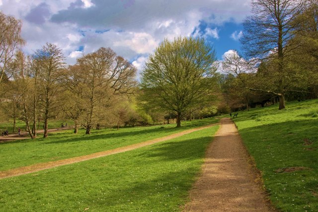
Ash Copse is a picturesque woodland located in Somerset, England. Covering an area of approximately 30 acres, it is a tranquil haven for nature lovers and outdoor enthusiasts alike. The copse is primarily composed of ash trees, which give it its name and dominate the landscape with their tall, slender trunks and distinctive black buds.

The woodland is home to a diverse range of flora and fauna, making it a popular destination for wildlife enthusiasts. Visitors may spot various species of birds, including woodpeckers, owls, and thrushes. The forest floor is adorned with a carpet of wildflowers during the spring and summer months, providing a vibrant burst of color and attracting an array of butterflies and insects.

A network of well-maintained footpaths winds its way through Ash Copse, allowing visitors to explore its beauty at their own pace. The paths offer stunning views of the surrounding countryside and provide opportunities for peaceful strolls or invigorating hikes. Benches and picnic areas are scattered throughout the woodland, inviting visitors to take a moment to relax and soak in the tranquil atmosphere.

Ash Copse is a designated Site of Special Scientific Interest (SSSI), highlighting its importance for biodiversity and conservation. The woodland is carefully managed to ensure the preservation of its unique ecosystem and protect its valuable habitats.

Whether it's a leisurely walk, a birdwatching excursion, or simply a desire to escape the hustle and bustle of everyday life, Ash Copse offers a serene and enchanting retreat for all who visit.

If you have any feedback on the listing, please let us know in the comments section below.

Ash Copse Images

Images are sourced within 2km of 50.930192/-2.6626162 or Grid Reference ST5314. Thanks to Geograph Open Source API. All images are credited.

Hilbourne Gardens, Yeovil
Houndstone Retail Park
Lay-by on A3088 south of Alvington On the edge of Yeovil, a convenient lay-by for commercial vehicles to pause before making deliveries in the town
Lay-by on A3088 south of Alvington
On the edge of Yeovil, a convenient lay-by for commercial vehicles to pause before making deliveries in the town
Council Offices by the A3088, Yeovil by-pass
Screwfix depot, Lynx Trading Estate, Yeovil At the junction of Lysander Road and Garrett Road
Screwfix depot, Lynx Trading Estate, Yeovil
At the junction of Lysander Road and Garrett Road
Morrisons supermarket and car park, Yeovil
Filling station, Morrisons, Yeovil
BM superstore, Lysander Road, Yeovil
Benchmark on East Coker School Ordnance Survey benchmark, described on database at <span class="nowrap"><a title="http://www.bench-marks.org.uk/bm66969" rel="nofollow ugc noopener" href="http://www.bench-marks.org.uk/bm66969">Link</a><img style="margin-left:2px;" alt="External link" title="External link - shift click to open in new window" src="https://s1.geograph.org.uk/img/external.png" width="10" height="10"/></span>.
Benchmark on East Coker School
Ordnance Survey benchmark, described on database at LinkExternal link.
Yeovil Country Park: Paths converge
Yeovil: Mural at Hendford Halt Painted on the wall of this former railway halt, the mural depicts changing times in the history of transport
Yeovil: Mural at Hendford Halt
Painted on the wall of this former railway halt, the mural depicts changing times in the history of transport
Camp Road
Camp Road
Screwfix on the Lynx Trading Estate, Yeovil
Veterinary surgery on Preston Road
St James's Church, Preston Plucknett, Yeovil
Driveway and lodge, Barwick House
Yeovil Country Park
Yeovil Country Park
The Forester's Arms, Holywell
Show me another place!

Ash Copse is located at Grid Ref: ST5314 (Lat: 50.930192, Lng: -2.6626162)

Administrative County: Somerset

District: South Somerset

Police Authority: Avon and Somerset

What 3 Words

///take.shot.chefs. Near West Coker, Somerset

Related Wikis

Naish Priory

Naish Priory in East Coker, Somerset, England, contains portions of a substantial house dating from the mid 14th century to around 1400. Emery says the...

Yeovil/Westland Airport

Yeovil Aerodrome (ICAO: EGHG), sometimes known as Yeovil/Westland (to avoid confusion with nearby RNAS Yeovilton), is located in Yeovil, Somerset, England...

Westland Sports F.C.

Westland Sports Football Club is a football club based in Yeovil, Somerset England. They currently play in the Dorset Premier League at their home ground...

West Hendford Cricket Ground

West Hendford Cricket Ground was a first-class cricket ground in Yeovil, Somerset. The land for the ground was first leased by Yeovil Cricket Club in 1874...

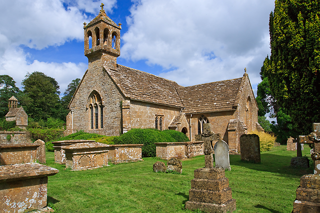
Church of St James, Preston Plucknett

The Church of St James in Preston Plucknett, Somerset, England, was built in 1420. It is a Grade II* listed building. == History == The church was built...

Hymerford House

Hymerford House (which has also been known as Grove Farm, Manor House and Bridge Farm) in East Coker, Somerset, England was built in the 15th century and...
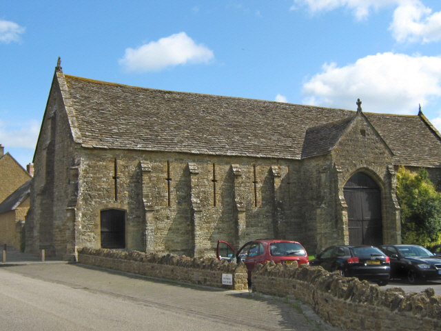
Abbey Barn, Yeovil

The Abbey Barn in Preston Plucknett, Yeovil, Somerset, England was built around 1420 by John Stourton (died 1438), in conjunction with the Abbey Farm House...

St Andrew's Church, Brympton

The Church of St Andrew in Brympton, Somerset, England, dates from the 13th century and has been designated as a Grade I listed building. It is closely...

Nearby Amenities

Located within 500m of 50.930192,-2.6626162
Source: os_opendata_VectorMap-District
Lat/Long: 50.930256/-2.663414
Source: os_opendata_VectorMap-District
Lat/Long: 50.932689/-2.662609
Source: os_opendata_VectorMap-District
Lat/Long: 50.9324997/-2.6609481
Source: os_opendata_VectorMap-District
Lat/Long: 50.93224/-2.6632428
Source: os_opendata_VectorMap-District
Lat/Long: 50.9291147/-2.659259
Source: os_opendata_VectorMap-District
Lat/Long: 50.9325593/-2.6630906
Source: os_opendata_VectorMap-District
Lat/Long: 50.9284012/-2.6593581
Source: os_opendata_VectorMap-District
Lat/Long: 50.931906/-2.661118
Source: os_opendata_VectorMap-District
Lat/Long: 50.932632/-2.661598
Source: os_opendata_VectorMap-District
Lat/Long: 50.9284345/-2.6591829
Source: os_opendata_VectorMap-District
Lat/Long: 50.929942/-2.656949
Source: os_opendata_VectorMap-District
Lat/Long: 50.931881/-2.65914
Source: os_opendata_VectorMap-District
Lat/Long: 50.93116/-2.662602
Source: os_opendata_VectorMap-District
Lat/Long: 50.931926/-2.660777
Source: os_opendata_VectorMap-District
Lat/Long: 50.9284361/-2.6602939
Source: os_opendata_VectorMap-District
Lat/Long: 50.92901/-2.661262
Source: os_opendata_VectorMap-District
Lat/Long: 50.932645/-2.6629788
Source: os_opendata_VectorMap-District
Lat/Long: 50.930606/-2.657158
Source: os_opendata_VectorMap-District
Lat/Long: 50.932088/-2.659086
Source: os_opendata_VectorMap-District
Lat/Long: 50.931805/-2.661544
Source: os_opendata_VectorMap-District
Lat/Long: 50.928585/-2.661555
Source: os_opendata_VectorMap-District
Lat/Long: 50.932596/-2.661469
Source: os_opendata_VectorMap-District
Lat/Long: 50.932686/-2.663036
Source: os_opendata_VectorMap-District
Lat/Long: 50.931715/-2.661485
Source: os_opendata_VectorMap-District
Lat/Long: 50.931274/-2.663172
Source: os_opendata_VectorMap-District
Lat/Long: 50.932099/-2.658844
Source: os_opendata_VectorMap-District
Lat/Long: 50.932261/-2.663514
Source: os_opendata_VectorMap-District
Lat/Long: 50.931099/-2.657563
Source: os_opendata_VectorMap-District
Lat/Long: 50.9285383/-2.6602241
Source: os_opendata_VectorMap-District
Lat/Long: 50.9287864/-2.6602576
Source: os_opendata_VectorMap-District
Lat/Long: 50.9322/-2.66162
Source: os_opendata_VectorMap-District
Lat/Long: 50.9283071/-2.6605722
Source: os_opendata_VectorMap-District
Lat/Long: 50.9291557/-2.6626546
Source: os_opendata_VectorMap-District
Lat/Long: 50.930526/-2.657029
Source: os_opendata_VectorMap-District
Lat/Long: 50.932166/-2.658133
Source: os_opendata_VectorMap-District
Lat/Long: 50.931034/-2.657804
Source: os_opendata_VectorMap-District
Lat/Long: 50.9284392/-2.6590095
Source: os_opendata_VectorMap-District
Lat/Long: 50.9324457/-2.6609699
Source: os_opendata_VectorMap-District
Lat/Long: 50.93067/-2.663335
Source: os_opendata_VectorMap-District
Lat/Long: 50.931628/-2.659364
Source: os_opendata_VectorMap-District
Lat/Long: 50.9323986/-2.6606649
Source: os_opendata_VectorMap-District
Lat/Long: 50.932492/-2.659177
Source: os_opendata_VectorMap-District
Lat/Long: 50.932412/-2.659176
Source: os_opendata_VectorMap-District
Lat/Long: 50.930014/-2.657036
Source: os_opendata_VectorMap-District
Lat/Long: 50.9282482/-2.6609925
Source: os_opendata_VectorMap-District
Lat/Long: 50.9313833/-2.6578127
Source: os_opendata_VectorMap-District
Lat/Long: 50.9291688/-2.6624799
Source: os_opendata_VectorMap-District
Lat/Long: 50.928629/-2.661726
Source: os_opendata_VectorMap-District
Lat/Long: 50.931796/-2.663066
Source: os_opendata_VectorMap-District
Lat/Long: 50.9327544/-2.6632704
Source: os_opendata_VectorMap-District
Lat/Long: 50.93245/-2.661852
Source: os_opendata_VectorMap-District
Lat/Long: 50.9283684/-2.660118
Source: os_opendata_VectorMap-District
Lat/Long: 50.932171/-2.663527
Source: os_opendata_VectorMap-District
Lat/Long: 50.931709/-2.659408
Source: os_opendata_VectorMap-District
Lat/Long: 50.931236/-2.663513
Source: os_opendata_VectorMap-District
Lat/Long: 50.931566/-2.659263
Source: os_opendata_VectorMap-District
Lat/Long: 50.9327304/-2.6633725
Source: os_opendata_VectorMap-District
Lat/Long: 50.931628/-2.662551
Source: os_opendata_VectorMap-District
Lat/Long: 50.930985/-2.658686
Source: os_opendata_VectorMap-District
Lat/Long: 50.931971/-2.659084
Source: os_opendata_VectorMap-District
Lat/Long: 50.932192/-2.65977
Source: os_opendata_VectorMap-District
Lat/Long: 50.931825/-2.662654
Source: os_opendata_VectorMap-District
Lat/Long: 50.932063/-2.661917
Source: os_opendata_VectorMap-District
Lat/Long: 50.931197/-2.662517
Source: os_opendata_VectorMap-District
Lat/Long: 50.931193/-2.663129
Source: os_opendata_VectorMap-District
Lat/Long: 50.930319/-2.663387
Source: os_opendata_VectorMap-District
Lat/Long: 50.931506/-2.663531
Source: os_opendata_VectorMap-District
Lat/Long: 50.931396/-2.662221
Source: os_opendata_VectorMap-District
Lat/Long: 50.9283301/-2.6613691
Source: os_opendata_VectorMap-District
Lat/Long: 50.932691/-2.6628209
Source: os_opendata_VectorMap-District
Lat/Long: 50.932722/-2.661528
Source: os_opendata_VectorMap-District
Lat/Long: 50.931726/-2.658028
Source: os_opendata_VectorMap-District
Lat/Long: 50.932481/-2.65966
Source: os_opendata_VectorMap-District
Lat/Long: 50.932565/-2.659164
Source: os_opendata_VectorMap-District
Lat/Long: 50.931881/-2.662356
Source: os_opendata_VectorMap-District
Lat/Long: 50.932568/-2.661654
Source: os_opendata_VectorMap-District
Lat/Long: 50.928578/-2.66127
Source: os_opendata_VectorMap-District
Lat/Long: 50.932566/-2.662038
Source: os_opendata_VectorMap-District
Lat/Long: 50.929228/-2.6611363
Source: os_opendata_VectorMap-District
Lat/Long: 50.9289406/-2.6601393
Source: os_opendata_VectorMap-District
Lat/Long: 50.9283763/-2.6603658
Source: os_opendata_VectorMap-District
Lat/Long: 50.931848/-2.663408
Source: os_opendata_VectorMap-District
Lat/Long: 50.931514/-2.657213
Source: os_opendata_VectorMap-District
Lat/Long: 50.931413/-2.659218
Source: os_opendata_VectorMap-District
Lat/Long: 50.931754/-2.65938
Source: os_opendata_VectorMap-District
Lat/Long: 50.931431/-2.662364
Source: os_opendata_VectorMap-District
Lat/Long: 50.931293/-2.66303
Source: os_opendata_VectorMap-District
Lat/Long: 50.932098/-2.658901
Source: os_opendata_VectorMap-District
Lat/Long: 50.9283952/-2.6588676
Source: os_opendata_VectorMap-District
Lat/Long: 50.9325786/-2.6609407
Source: os_opendata_VectorMap-District
Lat/Long: 50.930319/-2.657097
Tourism: hotel
Lat/Long: 50.926465/-2.666407
Crossing
Crossing: unmarked
Crossing Island: no
Lat/Long: 50.9330091/-2.6583313
Turning Circle
Lat/Long: 50.9266378/-2.6611758
Crossing
Crossing: unmarked
Tactile Paving: yes
Lat/Long: 50.9278278/-2.661551
YHC Hire Services Ltd
Shop: doityourself
Website: http://www.yhchireservices.com
Lat/Long: 50.9338743/-2.6651627
Crossing
Crossing: unmarked
Tactile Paving: yes
Lat/Long: 50.9277454/-2.661608
Crossing
Crossing: marked
Crossing Island: yes
Tactile Paving: yes
Lat/Long: 50.9280409/-2.6616649
Gregg's Riding School
Leisure: horse_riding
Lat/Long: 50.9274809/-2.6576248
Edmunson Electrical
Addr Housenumber: 30
Addr Postcode: BA20 2TJ
Addr Street: Garrett Road
Shop: electronics
Lat/Long: 50.9341252/-2.6595018
Fixme: when satellite imagery available
Note: roundabout replaced by junction
Lat/Long: 50.9331666/-2.6637641
Power: pole
Source: bing
Lat/Long: 50.9276384/-2.6626222
Power: pole
Source: bing
Lat/Long: 50.9277863/-2.6635113
Power: pole
Source: bing
Lat/Long: 50.9279841/-2.6647559
Power: pole
Source: bing
Lat/Long: 50.92816/-2.6658864
Power: pole
Source: bing
Lat/Long: 50.9294777/-2.6690407
Power: pole
Source: bing
Lat/Long: 50.9289351/-2.6677559
Power: pole
Source: bing
Lat/Long: 50.9281194/-2.6677653
Power: pole
Source: bing
Lat/Long: 50.9274229/-2.667768
Crossing
Crossing: unmarked
Tactile Paving: yes
Lat/Long: 50.9280839/-2.6619846
Crossing
Crossing: unmarked
Tactile Paving: yes
Lat/Long: 50.9280264/-2.6621065
The data included in this document is from www.openstreetmap.org. The data is made available under ODbL.

Have you been to Ash Copse?

Leave your review of Ash Copse below (or comments, questions and feedback).