Birch Wood

Wood, Forest in Cumberland Eden

England

Birch Wood

Crossing the Settle-Carlisle line This is where Fiddler’s Lane crosses the line. A winter view taken on a mid-December afternoon.
Crossing the Settle-Carlisle line Credit: Mary and Angus Hogg

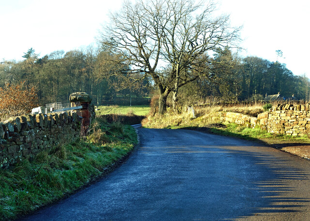
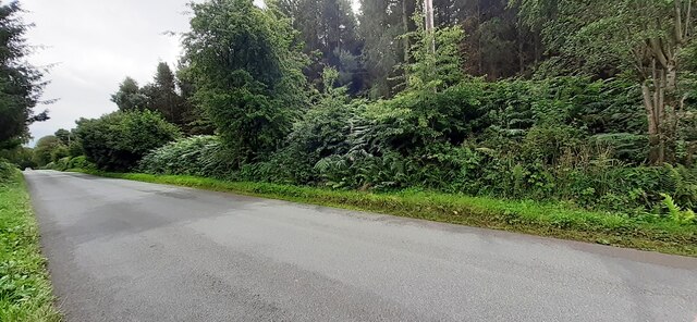
Birch Wood, Cumberland is a picturesque forest located in the county of Cumberland, England. Covering an area of approximately 500 acres, this woodland is characterized by its dense growth of birch trees, which give it its name. The forest is situated on the outskirts of the town of Cumberland, making it easily accessible to both locals and visitors.

The woodland is known for its natural beauty, with its tall, slender birch trees creating a stunning canopy overhead. The forest floor is covered in a carpet of green moss and wildflowers, adding to its charm. It is a haven for nature enthusiasts and hikers, offering numerous walking trails that wind through the woods, allowing visitors to fully immerse themselves in the tranquility of the surroundings.

The biodiversity in Birch Wood is also remarkable, with a wide range of flora and fauna calling this forest their home. Birdwatchers will be delighted by the variety of avian species that reside here, including woodpeckers, owls, and various songbirds. Squirrels, rabbits, and deer can also be spotted roaming freely in the forest, adding to the enchanting atmosphere.

Birch Wood, Cumberland is not only a place of natural beauty but also has historical significance. The forest has been mentioned in local folklore and has served as inspiration for many artists and writers throughout the years.

Overall, Birch Wood, Cumberland is a captivating woodland that offers visitors a chance to escape the hustle and bustle of everyday life and connect with nature. With its stunning scenery and rich biodiversity, it is truly a gem of Cumberland's natural landscape.

If you have any feedback on the listing, please let us know in the comments section below.

Birch Wood Images

Images are sourced within 2km of 54.742662/-2.7259856 or Grid Reference NY5338. Thanks to Geograph Open Source API. All images are credited.

Crossing the Settle-Carlisle line This is where Fiddler’s Lane crosses the line. A winter view taken on a mid-December afternoon.
Crossing the Settle-Carlisle line
This is where Fiddler’s Lane crosses the line. A winter view taken on a mid-December afternoon.
Benchmark on Cragnook Farm House Ordnance Survey cut mark benchmark levelled at 146.069m above Newlyn Datum verified 1972
Benchmark on Cragnook Farm House
Ordnance Survey cut mark benchmark levelled at 146.069m above Newlyn Datum verified 1972
Cragnook Farm farm house and access road There is an Ordnance Survey benchmark <a href="https://www.geograph.org.uk/photo/7245210">NY5340 : Benchmark on Cragnook Farm House</a> on the near corner, right hand face, of the farmhouse
Cragnook Farm farm house and access road
There is an Ordnance Survey benchmark NY5340 : Benchmark on Cragnook Farm House on the near corner, right hand face, of the farmhouse
Rural road through forestry NW of Crag Nook Ordnance Survey documents indicate that a benchmark levelled at 151.197m above Newlyn Datum was verified in 1972 on the side of the road here
Rural road through forestry NW of Crag Nook
Ordnance Survey documents indicate that a benchmark levelled at 151.197m above Newlyn Datum was verified in 1972 on the side of the road here
Fiddler's Lane and Railway Bridge, Lazonby Looking north-westward.
Fiddler's Lane and Railway Bridge, Lazonby
Looking north-westward.
Lazonby Farmland View Viewed from a train on a fine mid-February morning.
Lazonby Farmland View
Viewed from a train on a fine mid-February morning.
Avenue of Beech trees On the Lazonby estate.
Avenue of Beech trees
On the Lazonby estate.
Gateway to Bargeat Wath Plantation Signs on the gate indicated that felling is in progress.
Gateway to Bargeat Wath Plantation
Signs on the gate indicated that felling is in progress.
A sheep outstanding in its own field In a field overlooking the Lazonby auction mart - taken while waiting for a train later discovered to have been diverted over the West Coast Main line due to a derailment.
A sheep outstanding in its own field
In a field overlooking the Lazonby auction mart - taken while waiting for a train later discovered to have been diverted over the West Coast Main line due to a derailment.
Benchmarked gatepost on SW side of Fiddler's Lane Ordnance Survey cut mark benchmark levelled at 87.283m above Newlyn Datum
Benchmarked gatepost on SW side of Fiddler's Lane
Ordnance Survey cut mark benchmark levelled at 87.283m above Newlyn Datum
Looking northwest along Fiddler's Lane There is an Ordnance Survey benchmark <a href="https://www.geograph.org.uk/photo/6631813">NY5440 : Benchmarked gatepost on SW side of Fiddler's Lane</a> on the stone gatepost at the road end of a stone wall on the left hand side of the road
Looking northwest along Fiddler's Lane
There is an Ordnance Survey benchmark NY5440 : Benchmarked gatepost on SW side of Fiddler's Lane on the stone gatepost at the road end of a stone wall on the left hand side of the road
NE parapet of bridge taking Fiddler's Lane over Dyer's Beck
Lazonby Hall
Lazonby Hall
Sheep in field on NE side of Fiddler's Lane
Rough grazing near Lazonby Rough grazing near Lazonby.
Rough grazing near Lazonby
Rough grazing near Lazonby.
Benchmark on Bridge 309 (Settle-Carlisle line) Ordnance Survey cut mark benchmark described on the Bench Mark Database at <span class="nowrap"><a title="http://www.bench-marks.org.uk/bm43763" rel="nofollow ugc noopener" href="http://www.bench-marks.org.uk/bm43763">Link</a><img style="margin-left:2px;" alt="External link" title="External link - shift click to open in new window" src="https://s1.geograph.org.uk/img/external.png" width="10" height="10"/></span>
Benchmark on Bridge 309 (Settle-Carlisle line)
Ordnance Survey cut mark benchmark described on the Bench Mark Database at LinkExternal link
Railway bridge on Fiddler's Lane This is bridge 309 on the Settle-Carlisle line. There is an OS benchmark <a href="https://www.geograph.org.uk/photo/3027015">NY5440 : Benchmark on Bridge 309 (Settle-Carlisle line)</a> on the left hand parapet, 3 stones right of the end pier.
Railway bridge on Fiddler's Lane
This is bridge 309 on the Settle-Carlisle line. There is an OS benchmark NY5440 : Benchmark on Bridge 309 (Settle-Carlisle line) on the left hand parapet, 3 stones right of the end pier.
Benchmark on gatepost of Fiddlers Lane Ordnance Survey cut mark benchmark described on the Bench Mark Database at <span class="nowrap"><a title="http://www.bench-marks.org.uk/bm43762" rel="nofollow ugc noopener" href="http://www.bench-marks.org.uk/bm43762">Link</a><img style="margin-left:2px;" alt="External link" title="External link - shift click to open in new window" src="https://s1.geograph.org.uk/img/external.png" width="10" height="10"/></span>
Benchmark on gatepost of Fiddlers Lane
Ordnance Survey cut mark benchmark described on the Bench Mark Database at LinkExternal link
Show me another place!

Birch Wood is located at Grid Ref: NY5338 (Lat: 54.742662, Lng: -2.7259856)

Administrative County: Cumbria

District: Eden

Police Authority: Cumbria

What 3 Words

///prosper.issues.ribcage. Near Penrith, Cumbria

Related Wikis

Lazonby

Lazonby is a village and civil parish in the Lower Eden Valley of Cumbria; it is located about 8 miles (13 km) north-north-east of Penrith and 24 miles...

Lazonby & Kirkoswald railway station

Lazonby & Kirkoswald is a railway station on the Settle and Carlisle Line, which runs between Carlisle and Leeds via Settle. The station, which is situated...

Lacy's Caves

Lacy's Caves are a series of five chambers in the red sandstone cliff of the River Eden, just north of Little Salkeld, Cumbria, England, near Nunnery,...

Long Meg Mine

Long Meg Mine is a disused gypsum mine just north of Little Salkeld, Cumbria in the area known as Cave Wood Valley. It was operated between 1880 and 1976...

Kirkoswald, Cumbria

Kirkoswald is a village, civil parish, and former market town located in Westmorland and Furness, England, about 9 miles (14 km) from Penrith. The village...

Great Salkeld

Great Salkeld is a small village and civil parish in the Eden District of Cumbria, England, a few miles to the north east of Penrith and bordering the...

Kirkoswald Castle

Kirkoswald Castle is located to the southeast of the village of Kirkoswald, Cumbria, England. It is built from Penrith red sandstone and is still partially...

Little Salkeld rail accident

The Little Salkeld rail accident occurred on 19 January 1918 in Long Meg cutting, between Little Salkeld and Lazonby railway stations (about 15 miles south...

Nearby Amenities

Located within 500m of 54.742662,-2.7259856
Power: pole
Lat/Long: 54.744086/-2.7194612
The data included in this document is from www.openstreetmap.org. The data is made available under ODbL.

Have you been to Birch Wood?

Leave your review of Birch Wood below (or comments, questions and feedback).