Crowland Wood

Wood, Forest in Somerset Mendip

England

Crowland Wood

Westbury-Sub Mendip Church Saint Lawrence, with parts dating back to the 12th century.
Westbury-Sub Mendip Church Credit: Ian Rob

Crowland Wood is a picturesque woodland located in Somerset, England. Stretching over an area of approximately 100 acres, it is nestled in the heart of the beautiful Somerset countryside. The wood is a peaceful haven for nature enthusiasts and provides a tranquil escape from the bustling nearby towns.

Crowland Wood boasts a diverse range of tree species, including oak, beech, and ash, creating a rich and varied landscape. The wood is also home to a variety of wildlife, such as badgers, foxes, and numerous bird species. Visitors may be lucky enough to catch a glimpse of these animals as they explore the woodland trails.

The wood is crisscrossed by a network of well-maintained footpaths, allowing visitors to easily navigate the area and explore its hidden gems. These paths wind their way through the trees, leading visitors to enchanting clearings and small streams.

Throughout the year, Crowland Wood offers a changing landscape. In spring, visitors are treated to a stunning display of bluebells carpeting the forest floor, while in autumn, the wood transforms into a kaleidoscope of golden hues as the leaves change color.

The wood is a popular destination for hikers, dog walkers, and families seeking a peaceful day out in nature. The surrounding area also offers opportunities for picnicking and wildlife spotting. Additionally, there are educational programs and guided tours available, providing visitors with a deeper understanding of the wood's ecosystem and conservation efforts.

Overall, Crowland Wood is a charming woodland retreat that showcases the natural beauty of Somerset, offering visitors a chance to immerse themselves in nature and escape the stresses of everyday life.

If you have any feedback on the listing, please let us know in the comments section below.

Crowland Wood Images

Images are sourced within 2km of 51.232568/-2.69617 or Grid Reference ST5148. Thanks to Geograph Open Source API. All images are credited.

Westbury-Sub Mendip Church Saint Lawrence, with parts dating back to the 12th century.
Westbury-Sub Mendip Church
Saint Lawrence, with parts dating back to the 12th century.
St Lawrence's church, Westbury Originally C12; a little Norman work remains, but the tower was rebuilt in 1887, possibly reusing the former pinnacles <span class="nowrap"><a title="http://webapp1.somerset.gov.uk/her/details.asp?prn=22003" rel="nofollow ugc noopener" href="http://webapp1.somerset.gov.uk/her/details.asp?prn=22003">Link</a><img style="margin-left:2px;" alt="External link" title="External link - shift click to open in new window" src="https://s1.geograph.org.uk/img/external.png" width="10" height="10"/></span> .
St Lawrence's church, Westbury
Originally C12; a little Norman work remains, but the tower was rebuilt in 1887, possibly reusing the former pinnacles LinkExternal link .
Churchyard, Westbury-Sub-Mendip The churchyard on the north side of <a href="https://www.geograph.org.uk/photo/1878790">ST4948 : St Lawrence's church, Westbury</a>. In the background are barns at Court House Farm.
Churchyard, Westbury-Sub-Mendip
The churchyard on the north side of ST4948 : St Lawrence's church, Westbury. In the background are barns at Court House Farm.
St Lawrence's church, Westbury A view of <a href="https://www.geograph.org.uk/photo/1878790">ST4948 : St Lawrence's church, Westbury</a> from the south, showing the two-storey porch with its pierced parapet and empty niche. In a few minutes the sun would have illuminated more of the stonework, but breakfast called.
St Lawrence's church, Westbury
A view of ST4948 : St Lawrence's church, Westbury from the south, showing the two-storey porch with its pierced parapet and empty niche. In a few minutes the sun would have illuminated more of the stonework, but breakfast called.
Hollow Farm The lane is The Hollow, running from the centre of Westbury-Sub-Mendip to meet the A371 turnpike. Hollow Farm lies below Broadway Hill on the right.
Hollow Farm
The lane is The Hollow, running from the centre of Westbury-Sub-Mendip to meet the A371 turnpike. Hollow Farm lies below Broadway Hill on the right.
Towards Stoneleigh from The Hollow Looking across a couple of fields down the hill to the houses at Stoneleigh, which are along the A371 Stoke Road. The partly wooded Lodge Hill rises in the background.
Towards Stoneleigh from The Hollow
Looking across a couple of fields down the hill to the houses at Stoneleigh, which are along the A371 Stoke Road. The partly wooded Lodge Hill rises in the background.
Footpath up Broadway Hill The sign indicates the start of footpath WS 13/59 from The Hollow, but according to the maps it should leave the lane 100 metres further east. Two more footpaths cross the field.
Footpath up Broadway Hill
The sign indicates the start of footpath WS 13/59 from The Hollow, but according to the maps it should leave the lane 100 metres further east. Two more footpaths cross the field.
On Broadway Hill The line of yellow hawkweed roughly shows the line of footpath WS 13/17 down to meet The Hollow at the gate near the farm buildings. This is taken from footpath WS 13/59; the two paths cross just to the right of the camera. The two trees on a more steeply sloping bank suggest the line of a vanished field boundary.
On Broadway Hill
The line of yellow hawkweed roughly shows the line of footpath WS 13/17 down to meet The Hollow at the gate near the farm buildings. This is taken from footpath WS 13/59; the two paths cross just to the right of the camera. The two trees on a more steeply sloping bank suggest the line of a vanished field boundary.
Footpath down Broadway Hill The reverse view of <a href="https://www.geograph.org.uk/photo/1878942">ST4949 : Footpath up Broadway Hill</a>, with footpath WS 13/59 dropping to meet The Hollow. The nearest houses are at Stoneleigh on the A371, with Windmill Hill and Lodge Hill in the background.
Footpath down Broadway Hill
The reverse view of ST4949 : Footpath up Broadway Hill, with footpath WS 13/59 dropping to meet The Hollow. The nearest houses are at Stoneleigh on the A371, with Windmill Hill and Lodge Hill in the background.
On Broadway Hill Looking along the line of footpath WS 13/17 as it drops diagonally across the hillside towards The Hollow; see also <a href="https://www.geograph.org.uk/photo/1879003">ST4949 : On Broadway Hill</a>. The yellow flowers are Hawkweed.
On Broadway Hill
Looking along the line of footpath WS 13/17 as it drops diagonally across the hillside towards The Hollow; see also ST4949 : On Broadway Hill. The yellow flowers are Hawkweed.
Gunge tank, Broadway Hill Taken from close to the same spot as <a href="https://www.geograph.org.uk/photo/1879227">ST4949 : On Broadway Hill</a>, this is reminiscent of the "Poets Cornered" tub of gunk that Peter Cook, Dudley Moore and guest inevitably ended up in, in "Not Only ... But Also". Nevertheless, an important source of liquid for livestock on what is going to be a very hot weekend, and positioned so that animals in adjoining fields can enjoy a chat with their bevvy. Below is The Hollow, leading into Westbury-Sub-Mendip.
Gunge tank, Broadway Hill
Taken from close to the same spot as ST4949 : On Broadway Hill, this is reminiscent of the "Poets Cornered" tub of gunk that Peter Cook, Dudley Moore and guest inevitably ended up in, in "Not Only ... But Also". Nevertheless, an important source of liquid for livestock on what is going to be a very hot weekend, and positioned so that animals in adjoining fields can enjoy a chat with their bevvy. Below is The Hollow, leading into Westbury-Sub-Mendip.
On Broadway Hill Footpath WS 13/17 descends along a track, crossing into <a href="https://www.geograph.org.uk/gridref/ST5049">ST5049</a> on its way to Old Ditch.
On Broadway Hill
Footpath WS 13/17 descends along a track, crossing into ST5049 on its way to Old Ditch.
Tractor on Broadway Lane Not actually blocking footpath WS 13/17, as might appear, as the lane widens here. In the background is Old Ditch Farmhouse on Lynch Lane.
Tractor on Broadway Lane
Not actually blocking footpath WS 13/17, as might appear, as the lane widens here. In the background is Old Ditch Farmhouse on Lynch Lane.
Old Ditch Farmhouse The farmhouse may be originally C17 <span class="nowrap"><a title="http://webapp1.somerset.gov.uk/her/details.asp?prn=21993" rel="nofollow ugc noopener" href="http://webapp1.somerset.gov.uk/her/details.asp?prn=21993">Link</a><img style="margin-left:2px;" alt="External link" title="External link - shift click to open in new window" src="https://s1.geograph.org.uk/img/external.png" width="10" height="10"/></span> . On the immediate right is the farm cottage. Seen from Broadway Lane.
Old Ditch Farmhouse
The farmhouse may be originally C17 LinkExternal link . On the immediate right is the farm cottage. Seen from Broadway Lane.
Old Ditch Farm Another view of <a href="https://www.geograph.org.uk/photo/1879669">ST4949 : Old Ditch Farmhouse</a>, surrounded by its farm buildings <span class="nowrap"><a title="http://webapp1.somerset.gov.uk/her/details.asp?prn=21993" rel="nofollow ugc noopener" href="http://webapp1.somerset.gov.uk/her/details.asp?prn=21993">Link</a><img style="margin-left:2px;" alt="External link" title="External link - shift click to open in new window" src="https://s1.geograph.org.uk/img/external.png" width="10" height="10"/></span> . Behind are the slopes of the Mendips.
Old Ditch Farm
Another view of ST4949 : Old Ditch Farmhouse, surrounded by its farm buildings LinkExternal link . Behind are the slopes of the Mendips.
Reeds on a Public Footpath in the Somerset Levels
St Lawrence, Westbury-sub-Mendip: August 2023
Show me another place!

Crowland Wood is located at Grid Ref: ST5148 (Lat: 51.232568, Lng: -2.69617)

Administrative County: Somerset

District: Mendip

Police Authority: Avon and Somerset

What 3 Words

///encourage.barbarian.juggled. Near Wells, Somerset

Nearby Locations

Knap Wood Crowland Wood

Related Wikis

St Paul's Church, Easton

St Paul's Church is a Church of England church in Easton, Somerset, England. The church, which was designed by Richard Carver and built in 1843, has been...
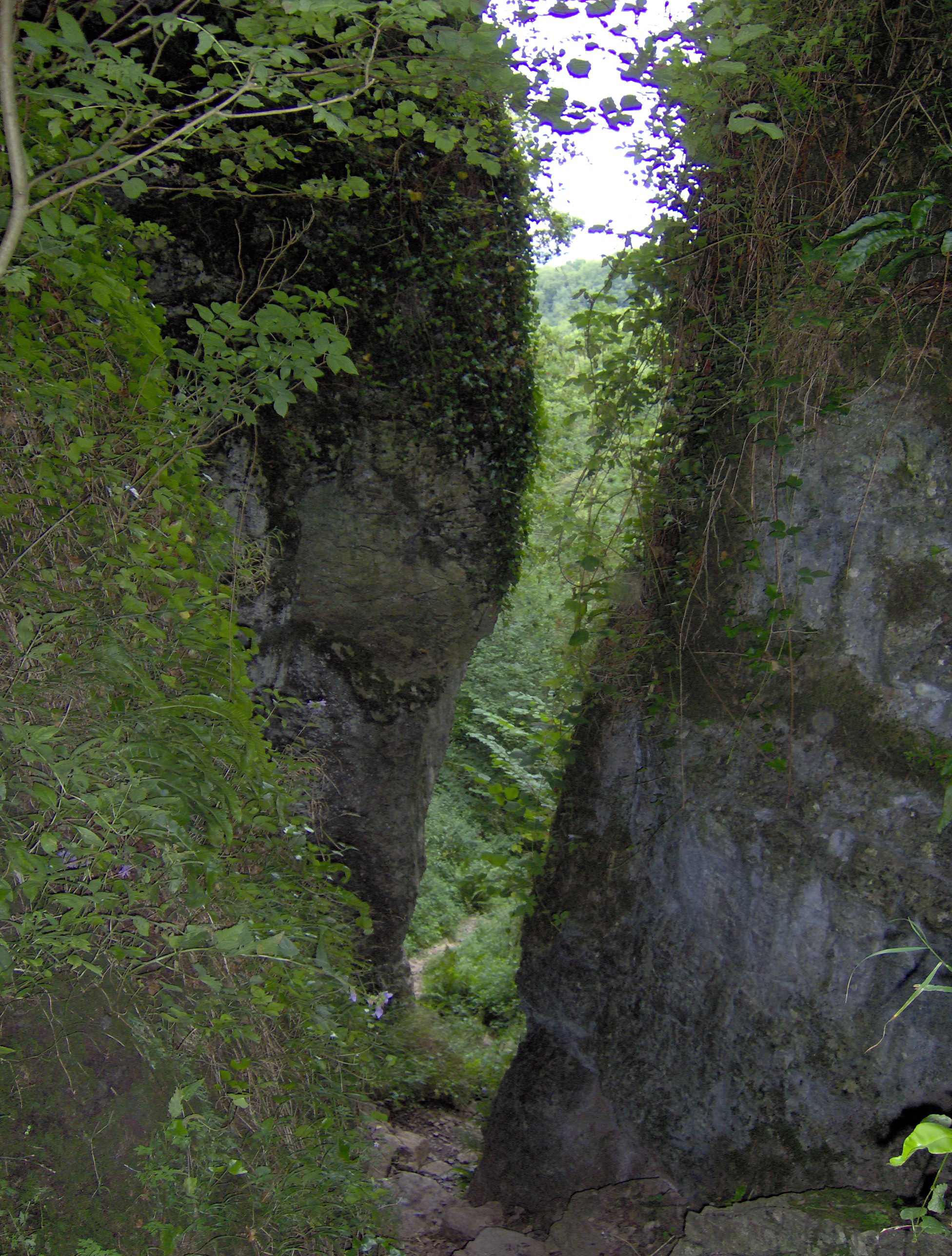
Ebbor Gorge

Ebbor Gorge is a limestone gorge in Somerset, England, designated and notified in 1952 as a 63.5-hectare (157-acre) biological Site of Special Scientific...

Westbury-sub-Mendip

Westbury-sub-Mendip is a village and civil parish in Somerset, England. The village is on the southern slopes of the Mendip Hills, 4 miles (6.4 km) from...

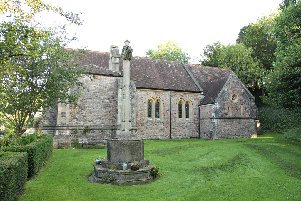
Church of St Lawrence, Westbury-sub-Mendip

The Church of St Lawrence in Westbury-sub-Mendip, Somerset, England was built in the 12th century. It is a Grade II* listed building. == History == The...

Lodge Hill railway station

Lodge Hill railway station was a station on the Bristol and Exeter Railway's Cheddar Valley line in Somerset, England from 1870 until 1963. The station...

Wookey Hole Caves

Wookey Hole Caves () are a series of limestone caverns, a show cave and tourist attraction in the village of Wookey Hole on the southern edge of the Mendip...

Wookey Hole

Wookey Hole is a village in Somerset, England. It is the location of the Wookey Hole show caves. == Location == Wookey Hole is located in the civil parish...

Church of St Mary Magdalene, Wookey Hole

The Church of St Mary Magdalene is a Church of England church in Wookey Hole, Somerset, England, dedicated to Jesus' companion Mary Magdalene. The church...

Nearby Amenities

Located within 500m of 51.232568,-2.69617
Deer Leap Standing Stones
Historic: archaeological_site
Lat/Long: 51.2360448/-2.6918919
Deer Leap Standing Stones
Historic: archaeological_site
Lat/Long: 51.2359155/-2.6917766
The data included in this document is from www.openstreetmap.org. The data is made available under ODbL.

Have you been to Crowland Wood?

Leave your review of Crowland Wood below (or comments, questions and feedback).