Colliston

Settlement in Angus

Scotland

Colliston

Minor road near to Southfield Looking south-westward.
Minor road near to Southfield Credit: Peter Wood

Colliston is a small village located in the county of Angus, Scotland. Situated in the eastern part of the country, it lies approximately 6 miles north of the town of Arbroath and 12 miles southeast of the city of Dundee. The village is set amidst picturesque countryside and offers a tranquil and peaceful atmosphere.

Despite its small size, Colliston has a strong sense of community and is home to a population of around 500 residents. The village features a range of amenities to cater to the needs of its inhabitants, including a primary school, a local shop, and a village hall which serves as a hub for various community activities.

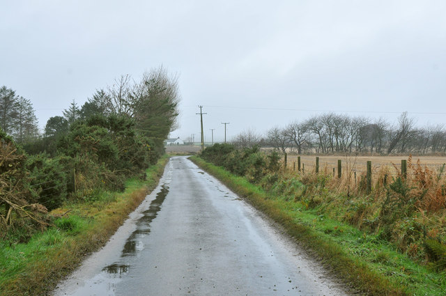
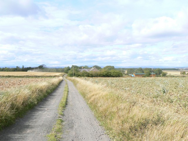
The surrounding area of Colliston boasts beautiful landscapes, with rolling hills and open fields, making it an ideal location for outdoor enthusiasts and nature lovers. The nearby Lunan Bay, a sandy beach located just a few miles to the east, provides a popular destination for locals and visitors alike.

Colliston is well-connected to neighboring towns and cities through a network of roads, making it easily accessible by car or public transportation. The A92 road runs nearby, linking the village to Dundee and Arbroath, while the nearby Arbroath railway station provides train services to various destinations across Scotland.

Overall, Colliston offers a peaceful retreat from the hustle and bustle of city life, with its quaint charm, stunning natural surroundings, and close-knit community spirit.

If you have any feedback on the listing, please let us know in the comments section below.

Colliston Images

Images are sourced within 2km of 56.596775/-2.645743 or Grid Reference NO6045. Thanks to Geograph Open Source API. All images are credited.

Minor road near to Southfield Looking south-westward.
Minor road near to Southfield
Looking south-westward.
Bicycle gate Green and yellow bikes on a gate at the entrance to Swirlburn.
Bicycle gate
Green and yellow bikes on a gate at the entrance to Swirlburn.
Minor road near Woodville
Elaborate sign for Swirlburn and surrounding farms
Minor road near West Mill of Colliston
Private road to Grange of Conon
Road to Parkconon Farm
Denmark A large farmstead off the A933 near Leysmill
Denmark
A large farmstead off the A933 near Leysmill
Arbroath to Forfar Crossroads A quaint countryside crossroads on the Arbroath to Forfar backroads.
Arbroath to Forfar Crossroads
A quaint countryside crossroads on the Arbroath to Forfar backroads.
House close to the road with woodland
West Mill of Colliston Mill on the Colliston Burn.
West Mill of Colliston
Mill on the Colliston Burn.
Soggy Field Near Firth Muir of Boysack Cairnconon Hill in the distance
Soggy Field Near Firth Muir of Boysack
Cairnconon Hill in the distance
Road to Guynd A long straight road near Arbroath.
Road to Guynd
A long straight road near Arbroath.
Potato pallets, Brax Cottage Big crop in Angus.
Potato pallets, Brax Cottage
Big crop in Angus.
Ryelands Around 1990 we estimated that about 1/3 of the registered ewes wintered on our farm.  Now they are a common and popular breed or breeds depending on your point of view re the "away strip".  The coloured Ryelands appeared in numbers during the 1980s after a year of numerous black lambs.   I like to think that my constant nagging did help in deciding to breed from them.
Ryelands
Around 1990 we estimated that about 1/3 of the registered ewes wintered on our farm. Now they are a common and popular breed or breeds depending on your point of view re the "away strip". The coloured Ryelands appeared in numbers during the 1980s after a year of numerous black lambs. I like to think that my constant nagging did help in deciding to breed from them.
Firth Muir of Boysack Road through arable farmland.  A new beech hedge has been laid, but some roads round here no longer have hedges.
Firth Muir of Boysack
Road through arable farmland. A new beech hedge has been laid, but some roads round here no longer have hedges.
Firth Muir of Boysack Barley stubble. In this arable area some of the hedges have gone.
Firth Muir of Boysack
Barley stubble. In this arable area some of the hedges have gone.
Show me another place!

Colliston is located at Grid Ref: NO6045 (Lat: 56.596775, Lng: -2.645743)

Unitary Authority: Angus

Police Authority: Tayside

What 3 Words

///puff.consoles.folk. Near Friockheim, Angus

Nearby Locations

Colliston

Related Wikis

Colliston

Colliston is a roadside hamlet in Angus, Scotland that is four miles north of Arbroath on the A933 Arbroath to Brechin road, in the parish of St Vigeans...
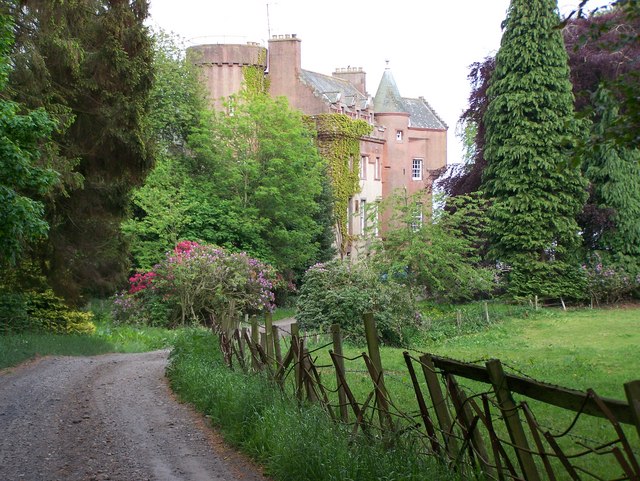
Colliston Castle

Colliston Castle is a 16th-century Z-plan tower house, altered and extended in the 18th and 19th centuries. It is located 6 kilometres (3.7 mi) north of...

Colliston railway station

Colliston railway station was a railway station at Colliston near Arbroath in Scotland.The station was opened on 24 November 1838 by the Arbroath and...

RM Condor

RM Condor is a large Royal Marines base located near Arbroath in East Angus, Scotland. The base also houses 7 (Sphinx) Battery Royal Artillery, part of...

Letham Grange estate

Letham Grange is a mansion and estate situated north of Arbroath, in Angus, Scotland. The mansion itself is category B listed. == History == The mansion...

45 Commando

45 Commando Royal Marines (pronounced "four-five commando") is a battalion sized unit of the British Royal Marines and subordinate unit within 3 Commando...

Leysmill railway station

Leysmill railway station served the village of Leysmill, Angus, Scotland from 1838 to 1955 on the Arbroath and Forfar Railway. == History == The station...

Letham Grange railway station

Letham Grange railway station served the Letham Grange estate, Angus, Scotland from 1883 to 1959 on the North British, Arbroath and Montrose Railway....

Nearby Amenities

Located within 500m of 56.596775,-2.645743
Note: village hall
Lat/Long: 56.5977303/-2.6429804
Recycling
Colliston Inn
Phone: +44 1241 890232
Postal Code: DD11 3RP
Tourism: hotel
Lat/Long: 56.594042/-2.644064
Colliston
Is In: Angus, Scotland, UK
Place: village
Wikidata: Q5147518
Wikipedia: en:Colliston
Lat/Long: 56.5950133/-2.644594
Bus Stop
Colliston Inn
Local Ref: at
Naptan AtcoCode: 6490IM004
Naptan Bearing: N
Naptan CommonName: Colliston Inn
Naptan Indicator: at Inn
Naptan Landmark: Colliston Inn
Naptan NaptanCode: 26423963
Naptan Street: A933
Naptan Verified: no
Source: naptan_import
Lat/Long: 56.5941083/-2.6434205
Bus Stop
Colliston Inn
Bench: yes
Local Ref: opp
Naptan AtcoCode: 6490IM439
Naptan Bearing: S
Naptan CommonName: Colliston Inn
Naptan Indicator: opp Inn
Naptan Landmark: Colliston Inn
Naptan NaptanCode: 26423964
Naptan Street: A933
Naptan Verified: no
Shelter: yes
Source: naptan_import
Lat/Long: 56.594963/-2.6439709
Cotton of Colliston
Place: hamlet
Lat/Long: 56.5969704/-2.6493014
Loanhead of Colliston
Place: isolated_dwelling
Lat/Long: 56.5984389/-2.6496276
The Craggan
Place: isolated_dwelling
Lat/Long: 56.6003179/-2.6453334
Colliston
Traffic Sign: city_limit
Traffic Sign Direction: forward
Lat/Long: 56.5972329/-2.6459415
Colliston
Traffic Sign: city_limit
Lat/Long: 56.5982153/-2.6415689
Post Box
Lat/Long: 56.5941614/-2.643479
Pub
The Colliston Inn
Lat/Long: 56.5939621/-2.6441683
Woodside Farm
Place: isolated_dwelling
Lat/Long: 56.5959814/-2.6473207
Power: pole
Lat/Long: 56.5927915/-2.642339
Power: pole
Lat/Long: 56.5980732/-2.6432694
Power: pole
Lat/Long: 56.5984143/-2.6422181
Power: pole
Lat/Long: 56.5987951/-2.640979
Power: pole
Lat/Long: 56.5991424/-2.6398711
Power: pole
Lat/Long: 56.5994038/-2.647701
Power: pole
Lat/Long: 56.5989009/-2.6472805
Power: pole
Lat/Long: 56.5983222/-2.6467921
Power: pole
Lat/Long: 56.597818/-2.6463648
Power: pole
Lat/Long: 56.597248/-2.6458538
Power: pole
Lat/Long: 56.5969449/-2.6486405
Power: pole
Lat/Long: 56.5976593/-2.6489684
Power: pole
Lat/Long: 56.5980751/-2.6491967
Power: pole
Lat/Long: 56.5985431/-2.6494726
The data included in this document is from www.openstreetmap.org. The data is made available under ODbL.

Have you been to Colliston?

Leave your review of Colliston below (or comments, questions and feedback).