Barbridge Withy Bed
Wood, Forest in Dorset
England
Barbridge Withy Bed

Barbridge Withy Bed is a picturesque woodland located in the county of Dorset, England. Situated in the heart of the county, this forested area spans over a vast expanse of approximately 200 acres. It is renowned for its natural beauty and tranquil ambiance, making it a popular destination for nature enthusiasts and outdoor enthusiasts alike.
The woodland is characterized by its dense canopy of trees, predominantly consisting of oak, ash, and beech. These towering trees provide ample shade and shelter for a diverse range of flora and fauna that call this forest home. The forest floor is adorned with a rich carpet of mosses, ferns, and wildflowers, creating a vibrant and enchanting atmosphere.
Barbridge Withy Bed is crisscrossed by a network of well-maintained walking trails, allowing visitors to explore the woodland at their leisure. From leisurely strolls to more challenging hikes, there is something for everyone. The trails wind through ancient woodland, offering glimpses of babbling brooks and small ponds that dot the landscape.
The forest is also home to a variety of wildlife, including deer, foxes, badgers, and numerous bird species. Birdwatchers will be delighted by the opportunity to spot woodpeckers, owls, and other woodland birds in their natural habitat.
For those seeking a peaceful retreat or a chance to reconnect with nature, Barbridge Withy Bed is the perfect destination. Its idyllic setting, diverse flora and fauna, and well-maintained trails make it a must-visit location in Dorset.
If you have any feedback on the listing, please let us know in the comments section below.
Barbridge Withy Bed Images
Images are sourced within 2km of 50.753713/-2.7935315 or Grid Reference SY4495. Thanks to Geograph Open Source API. All images are credited.


Barbridge Withy Bed is located at Grid Ref: SY4495 (Lat: 50.753713, Lng: -2.7935315)
Unitary Authority: Dorset
Police Authority: Dorset
What 3 Words
///still.surnames.tumble. Near Bridport, Dorset
Nearby Locations
Related Wikis

Atrim
Atrim is a small village in Dorset, England, just north of the large town, Bridport. It is situated on the River Simene. The nearest village is Dottery...

St Paul's Church, Broadoak
St Paul's Church is a Church of England church in Broadoak, Dorset, England. It was designed by Thomas Talbot Bury and built in 1865–66. The church has...

Symondsbury
Symondsbury () is a village and civil parish in southwest Dorset, England, 1.5 miles (2.4 km) west of Bridport and 16 miles (26 km) west of Dorchester...

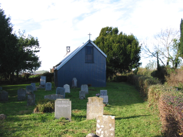
St Saviour's Church, Dottery
St Saviour's Church is a Church of England church in Dottery, Dorset, England. Erected in 1881–82, the corrugated iron church (Tin tabernacle) is the only...
Salway Ash
Salway Ash (also spelt Salwayash) is a village in Dorset, England. Holy Trinity Church was built there in 1887–89. == References ==
Pymore, Dorset
Pymore is a small village one mile north of Bridport, Dorset. Served by a pub, The Pymore Inn, Pymore has recently undergone a redevelopment - the site...

Holy Trinity Church, Salway Ash
Holy Trinity Church is a Church of England church in Salway Ash, Dorset, England. The church was designed by George Crickmay and built in 1887–89. It now...

Allington, Dorset
Allington is a village and civil parish in Dorset, England, 1 mile (1.6 km) north-west from the town of Bridport, with which it is physically contiguous...
Nearby Amenities
Located within 500m of 50.753713,-2.7935315Have you been to Barbridge Withy Bed?
Leave your review of Barbridge Withy Bed below (or comments, questions and feedback).