Bowlston Court Wood

Wood, Forest in Herefordshire

England

Bowlston Court Wood

View to the Black Mountains View to the Black Mountains from the road descending to Pontrilas.  This is a very similar view to the first picture uploaded into this grid square by me in February 2006 <a href="https://www.geograph.org.uk/photo/129564">SO4027 : Road approaching Pontrilas</a>.
View to the Black Mountains Credit: Philip Halling

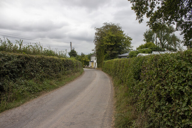
Bowlston Court Wood is a charming woodland located in Herefordshire, England. Covering an area of approximately 40 acres, this forest is a haven for nature enthusiasts and hikers alike.

The wood is predominantly made up of deciduous trees, with oak, ash, birch, and beech being the most common species found within its boundaries. The vibrant greens and browns of the foliage create a picturesque scene throughout the year, particularly during the autumn months when the leaves transform into brilliant shades of red, orange, and gold.

Traversing the wood, visitors will find a network of well-maintained footpaths that wind through the trees, allowing for leisurely strolls and peaceful contemplation. These paths also lead to several small clearings, perfect for picnics or simply taking a moment to appreciate the beauty of the surroundings.

Wildlife thrives in Bowlston Court Wood, with a variety of bird species making their homes among the branches. Visitors may be lucky enough to spot woodpeckers, owls, or even the elusive kingfisher along the nearby streams. The forest floor is also teeming with life, with squirrels darting between the trees and a diverse range of wildflowers and fungi adding bursts of color.

Bowlston Court Wood offers a tranquil retreat from the hustle and bustle of everyday life. Its natural beauty, diverse flora and fauna, and well-maintained paths make it a popular destination for both locals and tourists seeking a peaceful escape into nature.

If you have any feedback on the listing, please let us know in the comments section below.

Bowlston Court Wood Images

Images are sourced within 2km of 51.939068/-2.846588 or Grid Reference SO4127. Thanks to Geograph Open Source API. All images are credited.

View to the Black Mountains View to the Black Mountains from the road descending to Pontrilas.  This is a very similar view to the first picture uploaded into this grid square by me in February 2006 <a href="https://www.geograph.org.uk/photo/129564">SO4027 : Road approaching Pontrilas</a>.
View to the Black Mountains
View to the Black Mountains from the road descending to Pontrilas. This is a very similar view to the first picture uploaded into this grid square by me in February 2006 SO4027 : Road approaching Pontrilas.
Pontrilas Sawmills
Pontrilas Sawmills
Crab's Castle Farm Vernacular and modern farm buildings at Crab's Castle Farm
Crab's Castle Farm
Vernacular and modern farm buildings at Crab's Castle Farm
Cross Llyde Road at Cross Llyde
Cross Llyde
Road at Cross Llyde
Orchards Farm Field and hedgerows at Orchards Farm
Orchards Farm
Field and hedgerows at Orchards Farm
Milestone on the B4347 A milestone on the B4347 about a mile south of Pontrilas, Herefordshire which had been buried in the hedge before I found it - out came my trusty secateurs!  Milestone Society National ID = HF_PCMN10
Milestone on the B4347
A milestone on the B4347 about a mile south of Pontrilas, Herefordshire which had been buried in the hedge before I found it - out came my trusty secateurs! Milestone Society National ID = HF_PCMN10
Avenue at Kentchurch Leads from Kentchurch Court to a gatehouse by the River Monnow.
Avenue at Kentchurch
Leads from Kentchurch Court to a gatehouse by the River Monnow.
Avenue to Kentchurch Court
Entrance to Benarth Farm
The Lodge, Kentchurch Early nineteenth century lodge to Kentchurch Court <span class="nowrap"><a title="https://historicengland.org.uk/listing/the-list/list-entry/1099620?section=official-list-entry" rel="nofollow ugc noopener" href="https://historicengland.org.uk/listing/the-list/list-entry/1099620?section=official-list-entry">Link</a><img style="margin-left:2px;" alt="External link" title="External link - shift click to open in new window" src="https://s1.geograph.org.uk/img/external.png" width="10" height="10"/></span>
The Lodge, Kentchurch
Early nineteenth century lodge to Kentchurch Court LinkExternal link
Grass field and Grosmont Bridge Beyond the bridge is Wales.
Grosmont Bridge dates from 1817 and was designed by John Gethin <span class="nowrap"><a title="https://historicengland.org.uk/listing/the-list/list-entry/1099618?section=official-list-entry" rel="nofollow ugc noopener" href="https://historicengland.org.uk/listing/the-list/list-entry/1099618?section=official-list-entry">Link</a><img style="margin-left:2px;" alt="External link" title="External link - shift click to open in new window" src="https://s1.geograph.org.uk/img/external.png" width="10" height="10"/></span>
Grass field and Grosmont Bridge
Beyond the bridge is Wales. Grosmont Bridge dates from 1817 and was designed by John Gethin LinkExternal link
Kentchurch Old Rectory
A glimpse of St. Mary's church, Kentchurch
Churchyard cross, Kentchurch The base is medieval. The remainder dates from 1887. <span class="nowrap"><a title="https://historicengland.org.uk/listing/the-list/list-entry/1099614?section=official-list-entry" rel="nofollow ugc noopener" href="https://historicengland.org.uk/listing/the-list/list-entry/1099614?section=official-list-entry">Link</a><img style="margin-left:2px;" alt="External link" title="External link - shift click to open in new window" src="https://s1.geograph.org.uk/img/external.png" width="10" height="10"/></span>
Churchyard cross, Kentchurch
The base is medieval. The remainder dates from 1887. LinkExternal link
The churchyard, Kentchurch
St. Mary's church, Kentchurch The church was rebuilt in 1858-9 by Prichard and Seddon <span class="nowrap"><a title="https://historicengland.org.uk/listing/the-list/list-entry/1348834?section=official-list-entry" rel="nofollow ugc noopener" href="https://historicengland.org.uk/listing/the-list/list-entry/1348834?section=official-list-entry">Link</a><img style="margin-left:2px;" alt="External link" title="External link - shift click to open in new window" src="https://s1.geograph.org.uk/img/external.png" width="10" height="10"/></span>
St. Mary's church, Kentchurch
The church was rebuilt in 1858-9 by Prichard and Seddon LinkExternal link
Edward VII postbox, Kentchurch
Bridge at Kentchurch Crosses a small stream which drains Kentchurch Park.
Bridge at Kentchurch
Crosses a small stream which drains Kentchurch Park.
Show me another place!

Bowlston Court Wood is located at Grid Ref: SO4127 (Lat: 51.939068, Lng: -2.846588)

Unitary Authority: County of Herefordshire

Police Authority: West Mercia

What 3 Words

///rams.tickling.stages. Near Grosmont, Monmouthshire

Related Wikis

Kentchurch Court

Kentchurch Court is a Grade I listed stately home 1,200 yards (1,000 m) east from the village of Kentchurch in Herefordshire, England. == History == It...

Kentchurch

Kentchurch is a small village and civil parish in Herefordshire, England. It is located some 13 miles (21 km) south-west of Hereford and 13 miles (21...

River Dore

The River Dore (Welsh: Afon Aur lit: 'the river of gold') is a tributary of the River Monnow in Herefordshire, England. It rises on Cusop Hill, in the...

Kenderchurch

Kenderchurch is a village and former civil parish, now in the parish of Kilpeck, in the county of Herefordshire, England. In 2001 the parish had a population...

Pontrilas railway station

Pontrilas railway station is a former station which served the Herefordshire villages of Pontrilas and Ewyas Harold, and was a little distance from Grosmont...

Pontrilas

Pontrilas (English: Bridge over Three Rivers) is a village in south Herefordshire, England, half a mile from the border with Wales. It is in the parish...

Pontrilas Court

Pontrilas Court situated at the west end of the village Pontrilas in Herefordshire is a large stone Grade II* listed mansion and is marked on the 1904...

Bagwyllydiart

Bagwyllydiart is a hamlet in Herefordshire, England 16 kilometres (10 mi) south west of Hereford near the Welsh border. It lies between the villages of...

Nearby Amenities

Located within 500m of 51.939068,-2.846588
Barrier: stile
Source: survey
Lat/Long: 51.9401616/-2.8521962
Building: yes
Lat/Long: 51.9395738/-2.8490136
Barrier: stile
Source: survey
Lat/Long: 51.940667/-2.8507698
Barrier: stile
Source: survey
Lat/Long: 51.9433076/-2.8479883
Barrier: stile
Source: survey
Lat/Long: 51.943463/-2.847358
The data included in this document is from www.openstreetmap.org. The data is made available under ODbL.

Have you been to Bowlston Court Wood?

Leave your review of Bowlston Court Wood below (or comments, questions and feedback).