Sibdon Coppice

Wood, Forest in Shropshire

England

Sibdon Coppice

The Fish is down the hill and The Wart is straight on
The Fish is down the hill and The Wart is straight on Credit: Row17

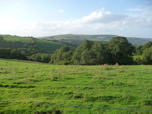
Sibdon Coppice is a small woodland area located in Shropshire, England. Situated near the village of Sibdon Carwood, it covers an area of approximately 30 acres. The coppice is part of the larger Sibdon Estate and is known for its diverse range of tree species and natural beauty.

The woodland is predominantly made up of broadleaf trees, including oak, beech, and ash. These trees provide a dense canopy, creating a shaded and tranquil environment. The forest floor is covered in a thick layer of leaf litter, which supports a variety of plant life such as bluebells, wood anemones, and wild garlic.

Sibdon Coppice has a rich history, with some areas dating back to the medieval period. It is believed that the woodland was once used as a source of timber for building and fuel. Today, it serves as a recreational space for locals and visitors alike, offering scenic walking trails and picnic spots.

The coppice is also home to a wide range of wildlife. Birds such as woodpeckers, owls, and thrushes can be spotted among the trees, while mammals like badgers, foxes, and deer are known to roam the area. The woodland provides a valuable habitat for these species, offering shelter and food sources.

Overall, Sibdon Coppice is a picturesque woodland area in Shropshire, offering a peaceful retreat for nature lovers and a haven for wildlife.

If you have any feedback on the listing, please let us know in the comments section below.

Sibdon Coppice Images

Images are sourced within 2km of 52.456639/-2.8727888 or Grid Reference SO4084. Thanks to Geograph Open Source API. All images are credited.

The Fish is down the hill and The Wart is straight on
Lane junction in Round Oak Shropshire has its share of intriguing place names, but 'The Fish' is surely right up there with the best.
Lane junction in Round Oak
Shropshire has its share of intriguing place names, but 'The Fish' is surely right up there with the best.
Road sign at Round Oak Nice accoutrement.
Road sign at Round Oak
Nice accoutrement.
View to the southern end of the Long Mynd from near Upper Carwood Black Knoll is visible on the ridge up. A fave walk of mine is all along the Long Mynd from the southern end northwards.
View to the southern end of the Long Mynd from near Upper Carwood
Black Knoll is visible on the ridge up. A fave walk of mine is all along the Long Mynd from the southern end northwards.
Ponies on Hopesay Common
Round Oak Looking up the hope towards the scattered houses at Round Oak.
Round Oak
Looking up the hope towards the scattered houses at Round Oak.
Machinery, Round Oak Assorted tools for arable farming in a field near Round Oak.
Machinery, Round Oak
Assorted tools for arable farming in a field near Round Oak.
Sheep troughs The sheep have been moved, leaving left overs for other livestock.
Sheep troughs
The sheep have been moved, leaving left overs for other livestock.
Behind Wart Hill Start of a stream running to the north of Wart Hill towards Cheney Longville.
Behind Wart Hill
Start of a stream running to the north of Wart Hill towards Cheney Longville.
Burrow View Farm, Hopesay Burrow View Farm looking West from Hopesay Common. Short Wood is on the horizon. One of the "Quietest places under the sun".
Burrow View Farm, Hopesay
Burrow View Farm looking West from Hopesay Common. Short Wood is on the horizon. One of the "Quietest places under the sun".
Another days work done
Footpath junction above Tadymoor Farm near Hopesay A misty morning on the route to Basford village.
Footpath junction above Tadymoor Farm near Hopesay
A misty morning on the route to Basford village.
Rounded hilltop on the footpath to Basford Curious bullocks resume their grazing behind us on this misty morning hilltop.
Rounded hilltop on the footpath to Basford
Curious bullocks resume their grazing behind us on this misty morning hilltop.
Hill grazing near Basford Misty morning near Basford.
Hill grazing near Basford
Misty morning near Basford.
Footpath west of Cheney Longville A misty, damp autumnal morning and a well used footpath/farm track. Somber mood at 11.00 am on 11 November, but so much to be thankful for being able to walk out in such peaceful countryside
Footpath west of Cheney Longville
A misty, damp autumnal morning and a well used footpath/farm track. Somber mood at 11.00 am on 11 November, but so much to be thankful for being able to walk out in such peaceful countryside
Footpath leading down to Longville Plantation Mist is lingering in the autumnal trees
Footpath leading down to Longville Plantation
Mist is lingering in the autumnal trees
Two ponds in Longville Plantation Good for wildlife, natural drainage and pheasant rearing.
Two ponds in Longville Plantation
Good for wildlife, natural drainage and pheasant rearing.
Emerging from Warthill Plantation The autumnal larches we’re trying to shrug off the morning’s cloud and mist - they succeeded soon after this photo was taken.
Emerging from Warthill Plantation
The autumnal larches we’re trying to shrug off the morning’s cloud and mist - they succeeded soon after this photo was taken.
Show me another place!

Sibdon Coppice is located at Grid Ref: SO4084 (Lat: 52.456639, Lng: -2.8727888)

Unitary Authority: Shropshire

Police Authority: West Mercia

What 3 Words

///brings.export.intestine. Near Craven Arms, Shropshire

Related Wikis

Cheney Longville Castle

Cheney Longville Castle was in the village of Cheney Longville to the north of Craven Arms, Shropshire (grid reference SO417847). It is a much restored...

Cheney Longville

Cheney Longville ( SHEH-nee LONG-vil) is a small village in Shropshire, England. It lies in the parish of Wistanstow, near to the small market town of...

Sibdon Carwood

Sibdon Carwood is a hamlet and parish in Shropshire, England. To the east is the town of Craven Arms. == Etymology and history == The place is occasionally...

Hopesay

Hopesay is a small village, and civil parish, in south Shropshire, England. The population of the parish at the 2011 census was 561.The name 'Hopesay'...

Related Videos

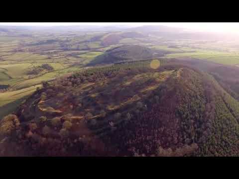
Burrow Iron Age Hill Fort Shropshire. 4K Drone

Burrow is a hill in Shropshire with an Iron Age hill fort at the summit known as Burrow Camp. The nearest villages are Hopesay ...

Nearby Amenities

Located within 500m of 52.456639,-2.8727888
Barrier: stile
Foot: yes
Lat/Long: 52.455595/-2.8752616
Power: pole
Lat/Long: 52.4559342/-2.8781471
Power: pole
Lat/Long: 52.4558868/-2.876763
Power: pole
Lat/Long: 52.4558345/-2.8754783
Material: wood
Power: pole
Lat/Long: 52.4557479/-2.8732386
Material: wood
Power: pole
Lat/Long: 52.4554847/-2.8723562
Material: wood
Power: pole
Lat/Long: 52.4550369/-2.871007
Material: wood
Power: pole
Lat/Long: 52.4546283/-2.8696659
The data included in this document is from www.openstreetmap.org. The data is made available under ODbL.

Have you been to Sibdon Coppice?

Leave your review of Sibdon Coppice below (or comments, questions and feedback).