Boggs Plantation

Wood, Forest in Cumberland Carlisle

England

Boggs Plantation

A path leading to The Mount Farm
A path leading to The Mount Farm Credit: Ian S

Boggs Plantation, located in Cumberland, is a captivating woodland area known for its dense forest and diverse plant life. Spread across several acres, this plantation is a nature lover's paradise, offering a tranquil escape from the bustling city life.

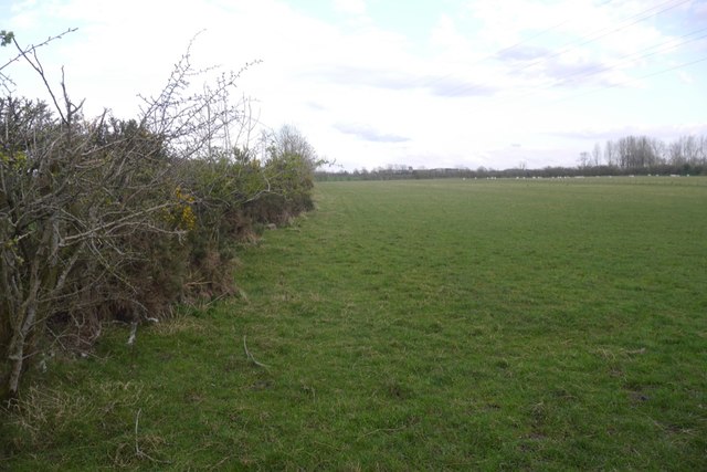
The plantation is characterized by its lush woodlands, featuring a variety of tree species such as oak, pine, and cedar, which create a picturesque landscape throughout the year. The forest floor is carpeted with a vibrant assortment of wildflowers, ferns, and mosses, adding to the area's natural beauty.

Boggs Plantation is also home to a thriving ecosystem, providing habitat for numerous animal species. Visitors may spot deer, squirrels, rabbits, and a variety of bird species, making it a popular destination for wildlife enthusiasts and birdwatchers.

Aside from its natural allure, the plantation offers recreational opportunities for visitors. Hiking trails wind through the forest, allowing visitors to explore and immerse themselves in the serene surroundings. There are also picnic areas and benches strategically placed, providing an ideal spot to relax and absorb the peaceful ambiance.

Preservation efforts play a crucial role in maintaining the plantation's pristine condition. Local authorities have implemented measures to protect the area's biodiversity, ensuring the sustainability of this natural haven for future generations to enjoy.

In conclusion, Boggs Plantation in Cumberland is a remarkable woodland area, boasting a rich variety of plants and wildlife. Whether it be for leisurely walks, birdwatching, or simply soaking in nature's beauty, this plantation offers an enchanting experience for all who visit.

If you have any feedback on the listing, please let us know in the comments section below.

Boggs Plantation Images

Images are sourced within 2km of 54.961704/-2.9590775 or Grid Reference NY3863. Thanks to Geograph Open Source API. All images are credited.

A path leading to The Mount Farm
Minor road near Dyke Nook
Grassland and Down by Rigg Farm
Grassland by Down by Rigg Farm
Field near Westlinton The low lying ground around the Solway Firth is usually used for grazing.
Field near Westlinton
The low lying ground around the Solway Firth is usually used for grazing.
Mount Hill House near Blackford.
Mount Hill
House near Blackford.
Minor road towards Scaleby
Junction of minor roads at Rigg
Cumberland County Council signpost at Rigg The signpost has Milestone Society National ID: CU_NY4064A.  The Barrockstown arm is a rather crude replacement for one which included Westlinton, see <span class="nowrap"><a title="http://www.geog.port.ac.uk/webmap/thelakes/photos/bzj38.jpg" rel="nofollow ugc noopener" href="http://www.geog.port.ac.uk/webmap/thelakes/photos/bzj38.jpg">Link</a><img style="margin-left:2px;" alt="External link" title="External link - shift click to open in new window" src="https://s1.geograph.org.uk/img/external.png" width="10" height="10"/></span>. See also <a href="https://www.geograph.org.uk/photo/6835343">NY4064 : Junction of minor roads at Rigg</a>
Cumberland County Council signpost at Rigg
The signpost has Milestone Society National ID: CU_NY4064A. The Barrockstown arm is a rather crude replacement for one which included Westlinton, see LinkExternal link. See also NY4064 : Junction of minor roads at Rigg
Benchmark on Riggmoor Bridge Ordnance Survey cut mark benchmark levelled at 23.239m above Newlyn Datum verified in 1972
Benchmark on Riggmoor Bridge
Ordnance Survey cut mark benchmark levelled at 23.239m above Newlyn Datum verified in 1972
NW parapet of Riggmoor Bridge There is an Ordnance Survey benchmark <a href="https://www.geograph.org.uk/photo/6835805">NY4063 : Benchmark on Riggmoor Bridge</a> on a stone at the base of the parapet about 1 foot from its left hand end
NW parapet of Riggmoor Bridge
There is an Ordnance Survey benchmark NY4063 : Benchmark on Riggmoor Bridge on a stone at the base of the parapet about 1 foot from its left hand end
Field with sheep on west side of road near Down By Rigg
Cumberland County Council finger signpost at Dike Nook The right hand finger indicates Alstonby 1¾ and Cliff 2¼
The signpost has Milestone Society National ID: CU_NY4063
Cumberland County Council finger signpost at Dike Nook
The right hand finger indicates Alstonby 1¾ and Cliff 2¼ The signpost has Milestone Society National ID: CU_NY4063
Road junction at Dyke Nook There is a close up photo of the Cumberland County Council signpost at <a href="https://www.geograph.org.uk/photo/6836437">NY4063 : Cumberland County Council finger signpost at Dike Nook</a>
Road junction at Dyke Nook
There is a close up photo of the Cumberland County Council signpost at NY4063 : Cumberland County Council finger signpost at Dike Nook
Name and date stone set into NW parapet of Riggmoor Bridge There is a wider view of the parapet at <a href="https://www.geograph.org.uk/photo/6835841">NY4063 : NW parapet of Riggmoor Bridge</a>. 
The stone has Milestone Society National ID CU_WLINT01br
Name and date stone set into NW parapet of Riggmoor Bridge
There is a wider view of the parapet at NY4063 : NW parapet of Riggmoor Bridge. The stone has Milestone Society National ID CU_WLINT01br
Benchmark on gatepost on west side of road SW of Down By Rigg Ordnance Survey cut mark benchmark levelled at 21.632m above Newlyn Datum verified in 1972
Benchmark on gatepost on west side of road SW of Down By Rigg
Ordnance Survey cut mark benchmark levelled at 21.632m above Newlyn Datum verified in 1972
Rural road heading north SW of Down By Rigg There is an Ordnance Survey benchmark <a href="https://www.geograph.org.uk/photo/6836477">NY4063 : Benchmark on gatepost on west side of road SW of Down By Rigg</a> on the road face of the gatepost at the far side of the former field gateway
Rural road heading north SW of Down By Rigg
There is an Ordnance Survey benchmark NY4063 : Benchmark on gatepost on west side of road SW of Down By Rigg on the road face of the gatepost at the far side of the former field gateway
Benchmark on Riggmoor House Ordnance Survey cut mark benchmark levelled at 25.097m above Newlyn Datum verified 1972 partly hidden by stacked building materials
Benchmark on Riggmoor House
Ordnance Survey cut mark benchmark levelled at 25.097m above Newlyn Datum verified 1972 partly hidden by stacked building materials
Show me another place!

Boggs Plantation is located at Grid Ref: NY3863 (Lat: 54.961704, Lng: -2.9590775)

Administrative County: Cumbria

District: Carlisle

Police Authority: Cumbria

What 3 Words

///driver.headlines.boil. Near Longtown, Cumbria

Nearby Locations

Boggs Plantation

Related Wikis

Nearby Amenities

Located within 500m of 54.961704,-2.9590775
Created By: Merkaartor 0.12
Lat/Long: 54.9579549/-2.9593991
Created By: Merkaartor 0.12
Lat/Long: 54.9611397/-2.9605471
Created By: Merkaartor 0.12
Lat/Long: 54.9631785/-2.9613303
Created By: Merkaartor 0.12
Lat/Long: 54.9637513/-2.9615342
Created By: Merkaartor 0.12
Lat/Long: 54.9640531/-2.9615771
Created By: Merkaartor 0.12
Lat/Long: 54.9644473/-2.9615235
Created By: Merkaartor 0.12
Lat/Long: 54.9656483/-2.9611265
Power: tower
Lat/Long: 54.957949/-2.9615701
Power: tower
Lat/Long: 54.9576844/-2.9601907
Power: tower
Lat/Long: 54.9587329/-2.955354
Power: pole
Lat/Long: 54.9648142/-2.9646472
Power: pole
Lat/Long: 54.9639904/-2.9622569
Power: pole
Lat/Long: 54.9638053/-2.9629043
Power: pole
Lat/Long: 54.9628661/-2.9625645
Power: pole
Lat/Long: 54.9623688/-2.962351
Power: pole
Lat/Long: 54.9621089/-2.961631
Power: pole
Lat/Long: 54.9621482/-2.9608776
Power: pole
Lat/Long: 54.9622215/-2.9599683
Power: pole
Lat/Long: 54.9623125/-2.9590751
Power: pole
Lat/Long: 54.9624135/-2.9581927
Power: pole
Lat/Long: 54.9625376/-2.957368
Power: pole
Lat/Long: 54.962577/-2.9566804
Power: tower
Lat/Long: 54.9597663/-2.959466
Power: tower
Lat/Long: 54.9617852/-2.9571286
Power: tower
Lat/Long: 54.9633619/-2.955303
The data included in this document is from www.openstreetmap.org. The data is made available under ODbL.

Have you been to Boggs Plantation?

Leave your review of Boggs Plantation below (or comments, questions and feedback).