Cae-newydd Wood

Wood, Forest in Herefordshire

England

Cae-newydd Wood

Grazing and trees near Rowlstone Park Farm
Grazing and trees near Rowlstone Park Farm Credit: JThomas

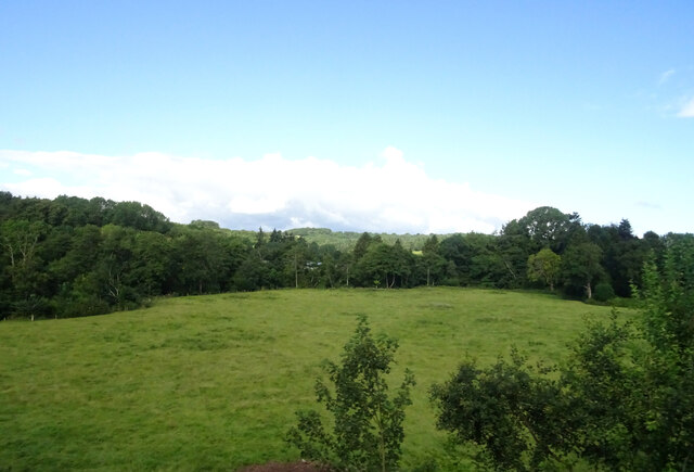
Cae-newydd Wood is a picturesque woodland located in the county of Herefordshire, England. Nestled in the heart of the countryside, this enchanting forest covers an area of approximately 100 acres and is a popular destination for nature enthusiasts and hikers alike.

The woodland is characterized by a diverse range of tree species, including oak, beech, ash, and birch. These towering trees create a dense canopy that filters sunlight, casting a dappled shadow on the forest floor below. The woodland is also home to a rich variety of flora, with wildflowers, ferns, and mosses adding an extra layer of beauty to the landscape.

Numerous well-maintained footpaths and trails wind their way through Cae-newydd Wood, providing visitors with the opportunity to explore the forest at their own pace. Wildlife is abundant in this natural haven, with a wide array of birds, mammals, and insects calling the woodland their home. Lucky visitors may even spot deer, foxes, and badgers as they wander through the trees.

Cae-newydd Wood offers a peaceful and tranquil atmosphere, perfect for those seeking respite from the hustle and bustle of everyday life. The forest is a popular spot for birdwatching, photography, and picnicking, with several designated areas providing space for visitors to relax and enjoy the natural surroundings.

Overall, Cae-newydd Wood is a captivating woodland that showcases the beauty of Herefordshire's countryside. Its stunning landscape, diverse flora and fauna, and well-maintained trails make it a must-visit destination for nature lovers and outdoor enthusiasts.

If you have any feedback on the listing, please let us know in the comments section below.

Cae-newydd Wood Images

Images are sourced within 2km of 51.943796/-2.8964758 or Grid Reference SO3827. Thanks to Geograph Open Source API. All images are credited.

Grazing and trees near Rowlstone Park Farm
Grazing towards the River Dore, Pontrilas
St Michael's Church St Michael's Church, Ewyas Harold (strictly the Church of St Michael and All Angels), seen from School Road.
St Michael's Church
St Michael's Church, Ewyas Harold (strictly the Church of St Michael and All Angels), seen from School Road.
St Michael's Church St Michael's Church, Ewyas Harold (strictly the Church of St Michael and All Angels).  Dating originally from the 13th Century, it is grade II listed - see <span class="nowrap"><a title="www.historicengland.org.uk/listing/the-list/list-entry/1348832" rel="nofollow ugc noopener" href="http://www.historicengland.org.uk/listing/the-list/list-entry/1348832">Link</a><img style="margin-left:2px;" alt="External link" title="External link - shift click to open in new window" src="https://s1.geograph.org.uk/img/external.png" width="10" height="10"/></span>.
St Michael's Church
St Michael's Church, Ewyas Harold (strictly the Church of St Michael and All Angels). Dating originally from the 13th Century, it is grade II listed - see LinkExternal link.
Ewyas Harold Road through Ewyas Harold, with the Temple Bar Inn on the right.
Ewyas Harold
Road through Ewyas Harold, with the Temple Bar Inn on the right.
Monks Retreat House by the entrance to the churchyard of St Michael's Church, Ewyas Harold, with the church itself in the background (see <a href="https://www.geograph.org.uk/photo/6951944">SO3828 : St Michael's Church</a>).
Monks Retreat
House by the entrance to the churchyard of St Michael's Church, Ewyas Harold, with the church itself in the background (see SO3828 : St Michael's Church).
Ewyas Harold Recreation Ground Sports field on the edge of Ewyas Harold.  The pavilion was refurbished in around 2015 following the award of a grant from the Premier League and FA Facilities Fund.
Ewyas Harold Recreation Ground
Sports field on the edge of Ewyas Harold. The pavilion was refurbished in around 2015 following the award of a grant from the Premier League and FA Facilities Fund.
Little Walk Mill Farm and Great Walk Mill Farm Pair of farms in the valley of the Dulas Brook near Ewyas Harold.  Great Walk Mill Farmhouse, behind the barn on the right, dates from the 17th or 18th Century and is grade II listed - see <span class="nowrap"><a title="www.historicengland.org.uk/listing/the-list/list-entry/1099610" rel="nofollow ugc noopener" href="http://www.historicengland.org.uk/listing/the-list/list-entry/1099610">Link</a><img style="margin-left:2px;" alt="External link" title="External link - shift click to open in new window" src="https://s1.geograph.org.uk/img/external.png" width="10" height="10"/></span>.
Little Walk Mill Farm and Great Walk Mill Farm
Pair of farms in the valley of the Dulas Brook near Ewyas Harold. Great Walk Mill Farmhouse, behind the barn on the right, dates from the 17th or 18th Century and is grade II listed - see LinkExternal link.
Home Farm Farm in the valley of the Dulas Brook near Ewyas Harold.
Home Farm
Farm in the valley of the Dulas Brook near Ewyas Harold.
Pontrilas Industrial Estate
Bridge farmhouse
Bridge farmhouse
Great Walk Mill Farm
Ewyas Harold Common Barn near Prospect Place, on the edge of Ewyas Harold Common.
Ewyas Harold Common
Barn near Prospect Place, on the edge of Ewyas Harold Common.
Ewyas Harold Common A grassy ride through bracken on Ewyas Harold Common.

The pink flowers on the left are of Meadow Saffron (Colchicum autumnale).  The plant is sometimes also known as Autumn Crocus, a name it shares with the non-native Crocus nudiflorus.  However despite these two alternative English names it is neither a true crocus, nor is it a source of saffron, which comes from Crocus sativus, of middle eastern origin. In fact all parts of Colchicum autumnale are deadly poisonous.

An unusual feature of this plant is that the flowers emerge in early autumn in isolation, after all other visible parts of the plant, such as the leaves, have disappeared, hence another common name, Naked Lady.
Ewyas Harold Common
A grassy ride through bracken on Ewyas Harold Common. The pink flowers on the left are of Meadow Saffron (Colchicum autumnale). The plant is sometimes also known as Autumn Crocus, a name it shares with the non-native Crocus nudiflorus. However despite these two alternative English names it is neither a true crocus, nor is it a source of saffron, which comes from Crocus sativus, of middle eastern origin. In fact all parts of Colchicum autumnale are deadly poisonous. An unusual feature of this plant is that the flowers emerge in early autumn in isolation, after all other visible parts of the plant, such as the leaves, have disappeared, hence another common name, Naked Lady.
Barn by Church Farm (Rowlestone) This barn was built in the 17th century with minor later additions, and was grade II listed in 1986.
Barn by Church Farm (Rowlestone)
This barn was built in the 17th century with minor later additions, and was grade II listed in 1986.
Lane at Rowlestone This lane is placed close to St. Peter's parish church and the village hall.
Lane at Rowlestone
This lane is placed close to St. Peter's parish church and the village hall.
Rowlestone village hall Here is the tin village hall by St. Peter's parish church, and there is a car park here.
Rowlestone village hall
Here is the tin village hall by St. Peter's parish church, and there is a car park here.
St. Peter's church (Rowlestone) Here is the grade I listed parish church of St. Peter, which has a nave that was built in the 12th century. The chancel is from the 15th century, while the bell tower is from the late 16th century. This was restored in 1865 and 1898, and is on a knoll.
St. Peter's church (Rowlestone)
Here is the grade I listed parish church of St. Peter, which has a nave that was built in the 12th century. The chancel is from the 15th century, while the bell tower is from the late 16th century. This was restored in 1865 and 1898, and is on a knoll.
Show me another place!

Cae-newydd Wood is located at Grid Ref: SO3827 (Lat: 51.943796, Lng: -2.8964758)

Unitary Authority: County of Herefordshire

Police Authority: West Mercia

What 3 Words

///parsnips.warthog.entire. Near Ewyas Harold, Herefordshire

Related Wikis

Ewyas Harold Castle

Ewyas Harold Castle was a castle in the village of Ewyas Harold in Herefordshire, England. == History == The first castle on the site is believed to be...

Ewyas Harold

Ewyas Harold () is a village and civil parish in the Golden Valley in Herefordshire, England, near the Wales-England border about halfway between Abergavenny...

Pontrilas Court

Pontrilas Court situated at the west end of the village Pontrilas in Herefordshire is a large stone Grade II* listed mansion and is marked on the 1904...

Pontrilas

Pontrilas (English: Bridge over Three Rivers) is a village in south Herefordshire, England, half a mile from the border with Wales. It is in the parish...

Rowlestone

Rowlestone (also spelled Rowlstone) is a village and civil parish in the county of Herefordshire in England. It is a rural area with agriculture the main...

Pontrilas railway station

Pontrilas railway station is a former station which served the Herefordshire villages of Pontrilas and Ewyas Harold, and was a little distance from Grosmont...

Monmouth Cap

Monmouth Cap is a hamlet in the north of the county of Monmouthshire, Wales. It stands to the north of the village of Grosmont, and to the south of the...

Llangua

Llangua (Welsh: Llangiwa) is a small village in Grosmont community, Monmouthshire, south-east Wales, United Kingdom. Saint Ciwa is said to have built a...

Related Videos

LLAMA TREKKING - GOLDEN VALLEY LLAMAS - OLD KING STREET FARM - HEREFORD

llamatrekking #Goldenvalleyllamas #Oldkingstreetfarm #llamas Alesha and "The Bullet" have a great time and make some new ...

Fun at the Little Blue Elephant Play Cafe

Situated in Ewyas Harold, Herefordshire, is the wonderful Blue Elephant play cafe. With a huge emphasis on playing, being ...

Nearby Amenities

Located within 500m of 51.943796,-2.8964758
Barrier: stile
Foot: yes
Lat/Long: 51.9427134/-2.8933072
Barrier: stile
Foot: yes
Lat/Long: 51.9427838/-2.8931059
Barrier: stile
Foot: yes
Lat/Long: 51.9440114/-2.893431
The data included in this document is from www.openstreetmap.org. The data is made available under ODbL.

Have you been to Cae-newydd Wood?

Leave your review of Cae-newydd Wood below (or comments, questions and feedback).