Main Covert

Wood, Forest in Dorset East Devon

England

Main Covert

St John the Baptist, Hawkchurch, Devon
St John the Baptist, Hawkchurch, Devon Credit: Ray Jennings

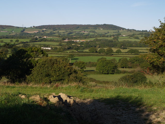
Main Covert is a wood located in the county of Dorset, England. Situated in the heart of the county, it is known for its dense forest and abundant natural beauty. Main Covert covers an area of approximately 100 acres, making it a significant woodland in the region.

The wood is predominantly composed of broadleaf trees, including oak, beech, and ash, which create a vibrant and diverse ecosystem. The dense canopy of the trees provides shade and shelter for a variety of wildlife, such as deer, foxes, and a wide range of bird species. The forest floor is covered with a lush carpet of ferns, bluebells, and other wildflowers, adding to the picturesque scenery.

Main Covert is a popular destination for nature lovers and outdoor enthusiasts. It offers a network of well-maintained walking trails that wind through the woodland, allowing visitors to explore its beauty at their own pace. The tranquil atmosphere and peaceful surroundings make it an ideal place for walking, picnicking, or simply enjoying the serenity of nature.

The wood is also a haven for birdwatchers, providing opportunities to spot rare and migratory birds. Its secluded location and relatively undisturbed environment offer a sanctuary for these winged creatures, making it a favored spot for birdwatching enthusiasts.

Overall, Main Covert in Dorset is a captivating woodland that showcases the natural beauty of the region. Its diverse flora and fauna, combined with its peaceful ambiance, make it a must-visit destination for those seeking a connection with nature.

If you have any feedback on the listing, please let us know in the comments section below.

Main Covert Images

Images are sourced within 2km of 50.791238/-2.9186482 or Grid Reference SY3599. Thanks to Geograph Open Source API. All images are credited.

St John the Baptist, Hawkchurch, Devon
St. John the Baptist, Hawkchurch, Devon
St. John the Baptist, Hawkchurch, Devon A beautiful reredos
St. John the Baptist, Hawkchurch, Devon
A beautiful reredos
St. John the Baptist, Hawkchurch, Devon The font
St. John the Baptist, Hawkchurch, Devon
The font
Cross and cottages, Hawkchurch
Brimley Hill
Brimley Hill
Church of St John the Baptist, Hawkchurch, Devon
Church of St John the Baptist, Hawkchurch, Devon The nave
Church of St John the Baptist, Hawkchurch, Devon
The nave
Church of St John the Baptist, Hawkchurch, Devon
Church of St John the Baptist, Hawkchurch, Devon The Chancel
Church of St John the Baptist, Hawkchurch, Devon
The Chancel
Church of St John the Baptist, Hawkchurch, Devon The Sanctuary and a beautiful Altar cloth.
Church of St John the Baptist, Hawkchurch, Devon
The Sanctuary and a beautiful Altar cloth.
Church of St John the Baptist, Hawkchurch, Devon The North window of the Sanctuary.
Church of St John the Baptist, Hawkchurch, Devon
The North window of the Sanctuary.
Church of St John the Baptist, Hawkchurch, Devon The East window.
Church of St John the Baptist, Hawkchurch, Devon
The East window.
Church of St John the Baptist, Hawkchurch, Devon The South wall window of the Sanctuary.
Church of St John the Baptist, Hawkchurch, Devon
The South wall window of the Sanctuary.
Church of St John the Baptist, Hawkchurch, Devon South wall window.
Church of St John the Baptist, Hawkchurch, Devon
South wall window.
Show me another place!

Main Covert is located at Grid Ref: SY3599 (Lat: 50.791238, Lng: -2.9186482)

Administrative County: Devon

District: East Devon

Police Authority: Devon and Cornwall

What 3 Words

///firebird.blurts.snapped. Near Axminster, Devon

Nearby Locations

Main Covert Tanglewood

Related Wikis

Hawkchurch

Hawkchurch is a village and civil parish in Devon, England, 3 miles (5 km) north east of Axminster on the border of Devon and Dorset, and about 6 miles...

Lambert's Castle

Lambert's Castle is an Iron Age hillfort in the county of Dorset in southwest England. Since 1981 it has been designated as a Site of Special Scientific...

St John's Church, Fishpond Bottom

St John's Church is a Church of England church in Fishpond Bottom, Dorset, England. It was built in 1852 and has been a Grade II listed building since...

Lambert's Castle Hill

Lambert's Castle Hill (258 metres, 846 feet high) rises between the villages of Marshwood and Fishpond Bottom in the county of Dorset, England. It is...

The Bottle Inn

The Bottle Inn is a 16th-century public house at Marshwood in Dorset, England which hosts the World Nettle Eating Championship. It is Grade II listed....

Coney's Castle

Coney's Castle is an Iron Age hillfort in Dorset, England. The name Coney is from the Old English for rabbit (Latin cuniculus), suggesting medieval use...

Marshwood

Marshwood is a village and civil parish in west Dorset, England, situated on the northern edge of the Marshwood Vale approximately 5.5 miles (8.9 km) northeast...

St Mary's Church, Marshwood

St Mary's Church is a Church of England church in Marshwood, Dorset, England. The earliest part of the church is the tower, which dates to 1840, while...

Nearby Amenities

Located within 500m of 50.791238,-2.9186482
Material: wood
Power: pole
Source: bing
Lat/Long: 50.786885/-2.9195161
Material: wood
Power: pole
Lat/Long: 50.7870785/-2.916753
Material: wood
Power: pole
Lat/Long: 50.7871428/-2.9183948
Location Transition: yes
Material: wood
Poles: bipole
Power: pole
Source: bing
Lat/Long: 50.7872203/-2.9200265
Material: wood
Power: pole
Source: bing
Lat/Long: 50.7874013/-2.9221739
Material: wood
Power: pole
Source: bing
Lat/Long: 50.7874166/-2.9213648
Material: wood
Power: pole
Source: bing
Lat/Long: 50.7874248/-2.9220312
Material: wood
Power: pole
Source: bing
Lat/Long: 50.7874391/-2.9207585
Material: wood
Power: pole
Source: bing
Lat/Long: 50.7874474/-2.9218265
Material: wood
Power: pole
Source: bing
Lat/Long: 50.7874523/-2.9217177
Material: wood
Power: pole
Source: bing
Lat/Long: 50.7883626/-2.9222275
Material: wood
Power: pole
Source: bing
Lat/Long: 50.7883918/-2.9220116
Material: wood
Power: pole
Source: bing
Lat/Long: 50.7886052/-2.9226575
Material: wood
Power: pole
Source: bing
Lat/Long: 50.7892121/-2.9225447
Material: wood
Power: pole
Source: bing
Lat/Long: 50.7893666/-2.9228549
Material: wood
Power: pole
Source: bing
Lat/Long: 50.7895843/-2.9231905
Material: wood
Power: pole
Source: bing
Lat/Long: 50.790302/-2.9232525
Power: pole
Lat/Long: 50.790122/-2.9234861
Power: pole
Lat/Long: 50.7902259/-2.923396
Power: pole
Lat/Long: 50.7910764/-2.9250032
Power: pole
Lat/Long: 50.7912992/-2.9240771
Power: pole
Lat/Long: 50.7913745/-2.9239521
Power: pole
Lat/Long: 50.7923926/-2.9248072
Power: pole
Lat/Long: 50.792472/-2.9246813
Power: tower
Source: bing
Lat/Long: 50.7884532/-2.9155517
Power: tower
Source: bing
Lat/Long: 50.7905089/-2.912449
Power: pole
Lat/Long: 50.7883083/-2.9134852
Power: pole
Lat/Long: 50.7887712/-2.912761
The data included in this document is from www.openstreetmap.org. The data is made available under ODbL.

Have you been to Main Covert?

Leave your review of Main Covert below (or comments, questions and feedback).