Slough Breast Wood

Wood, Forest in Herefordshire

England

Slough Breast Wood

Old Milestone west of Slough Bridge, Turnastone, St Margarets parish Carved stone post by the UC road, in parish of ST MARGARETS (District), 60m West of Slough Bridge, Turnastone, Cothill, on the verge, on North side of road.   Erected by the Hereford turnpike trust in the 19th century. 

Inscription reads:-
Hereford
12

Herefordshire SMR.  
SMR Number: 56630 <span class="nowrap"><a title="https://www.heritagegateway.org.uk/Gateway/Results_Single.aspx?uid=MHE28386&resourceID=101" rel="nofollow ugc noopener" href="https://www.heritagegateway.org.uk/Gateway/Results_Single.aspx?uid=MHE28386&resourceID=101">Link</a><img style="margin-left:2px;" alt="External link" title="External link - shift click to open in new window" src="https://s1.geograph.org.uk/img/external.png" width="10" height="10"/></span>


Milestone Society National ID: HF_HFME12.
Old Milestone west of Slough Bridge, Turnastone, St Margarets parish Credit: M Faherty

Slough Breast Wood is a picturesque and enchanting woodland located in Herefordshire, England. Spanning over a vast area, it is a tranquil haven for nature enthusiasts and those seeking solace amidst the beauty of nature. The wood is situated near the town of Hereford, making it easily accessible for visitors.

This ancient forest is renowned for its rich biodiversity, boasting a diverse range of flora and fauna. The woodland is predominantly composed of deciduous trees, including oak, beech, and ash, which form a dense canopy overhead. The forest floor is carpeted with an array of wildflowers, creating a vibrant and colorful tapestry during the spring and summer months.

The wood is crisscrossed by a network of well-maintained footpaths and trails, allowing visitors to explore its splendors at their own pace. These paths wind through the towering trees, offering glimpses of sunlight filtering through the foliage and creating a magical atmosphere.

Wildlife thrives in Slough Breast Wood, with an abundance of species inhabiting its diverse ecosystems. Birdwatchers can spot various species, including woodpeckers, owls, and songbirds, while lucky visitors may even catch a glimpse of elusive mammals such as deer and foxes.

The wood is a cherished site for nature conservation and is managed to protect its unique features. It offers a peaceful and serene environment for nature lovers to unwind, explore, and connect with the natural world. Slough Breast Wood is truly a hidden gem in the heart of Herefordshire, offering a memorable experience for all who venture into its embrace.

If you have any feedback on the listing, please let us know in the comments section below.

Slough Breast Wood Images

Images are sourced within 2km of 52.014338/-2.959478 or Grid Reference SO3435. Thanks to Geograph Open Source API. All images are credited.

Old Milestone west of Slough Bridge, Turnastone, St Margarets parish Carved stone post by the UC road, in parish of ST MARGARETS (District), 60m West of Slough Bridge, Turnastone, Cothill, on the verge, on North side of road.   Erected by the Hereford turnpike trust in the 19th century. 

Inscription reads:-
Hereford
12

Herefordshire SMR.  
SMR Number: 56630 <span class="nowrap"><a title="https://www.heritagegateway.org.uk/Gateway/Results_Single.aspx?uid=MHE28386&resourceID=101" rel="nofollow ugc noopener" href="https://www.heritagegateway.org.uk/Gateway/Results_Single.aspx?uid=MHE28386&resourceID=101">Link</a><img style="margin-left:2px;" alt="External link" title="External link - shift click to open in new window" src="https://s1.geograph.org.uk/img/external.png" width="10" height="10"/></span>


Milestone Society National ID: HF_HFME12.
Old Milestone west of Slough Bridge, Turnastone, St Margarets parish
Carved stone post by the UC road, in parish of ST MARGARETS (District), 60m West of Slough Bridge, Turnastone, Cothill, on the verge, on North side of road. Erected by the Hereford turnpike trust in the 19th century. Inscription reads:- Hereford 12 Herefordshire SMR. SMR Number: 56630 LinkExternal link Milestone Society National ID: HF_HFME12.
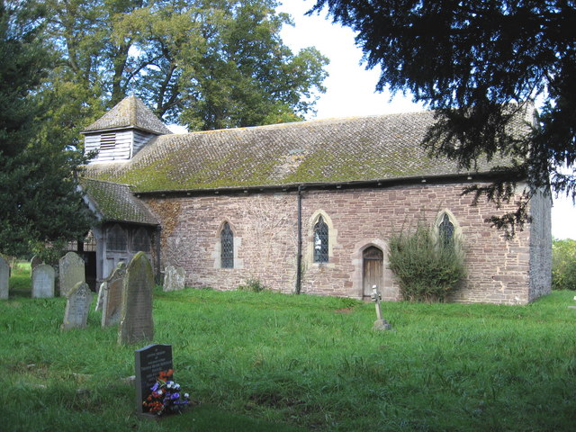
St Mary Magdalene's Church, Turnastone Turnastone is a hamlet in the Golden Valley, in the South Herefordshire district. It is 10 miles W of Hereford and the nearest village is Vowchurch, less than half a mile to the E.  The church has an aisleless nave and chancel in one with a low weatherboarded timber bell turret with a pyramid roof over the W gable and a timber S porch.
St Mary Magdalene's Church, Turnastone
Turnastone is a hamlet in the Golden Valley, in the South Herefordshire district. It is 10 miles W of Hereford and the nearest village is Vowchurch, less than half a mile to the E. The church has an aisleless nave and chancel in one with a low weatherboarded timber bell turret with a pyramid roof over the W gable and a timber S porch.
Petrol Pump at West End Garage (Turnastone) One of the two antique petrol pumps at West End Garage in Turnastone.
Petrol Pump at West End Garage (Turnastone)
One of the two antique petrol pumps at West End Garage in Turnastone.
St Mary Magdalene, Turnastone, Heref
St Mary Magdalene, Turnastone, Heref - Porch
St Mary Magdalene, Turnastone, Heref - East end
St Mary Magdalene, Turnastone, Heref - Window Depicting Saint Leomard
St Mary Magdalene, Turnastone, Heref - Window
Depicting Saint Leomard
Farm track at Shegear farm, near Turnastone The Black Mountains can be seen on the horizon.
Farm track at Shegear farm, near Turnastone
The Black Mountains can be seen on the horizon.
Sheep and lambs on Dolward Farm Dolward Farm is on high ground to the west of the Golden Valley which can be seen in the distance.
Sheep and lambs on Dolward Farm
Dolward Farm is on high ground to the west of the Golden Valley which can be seen in the distance.
Plough on rough ground opposite Brighton House
Road past Little Green Farm Little Green Farm can be seen in the middle distance.
Road past Little Green Farm
Little Green Farm can be seen in the middle distance.
Upper Maes Coed Chapel A Primitive Methodist chapel built in 1924 which appears to be in current use.
Upper Maes Coed Chapel
A Primitive Methodist chapel built in 1924 which appears to be in current use.
Turnastone - Old Garage The sign says it is open and the pump price is £1 a litre!
Turnastone - Old Garage
The sign says it is open and the pump price is £1 a litre!
Meadow Country meadow at Merryhurst Green.
Meadow
Country meadow at Merryhurst Green.
Herefordshire Countryside Just by the footpath that heads towards Cothill Farm.
Herefordshire Countryside
Just by the footpath that heads towards Cothill Farm.
Towards Lower House Wood Taken by Slough Bridge.
Towards Lower House Wood
Taken by Slough Bridge.
Meadow and Water Bowser Taken from a spot just a few hundred metres from the church at St Margarets.
Meadow and Water Bowser
Taken from a spot just a few hundred metres from the church at St Margarets.
Upper Gilvach The notice for the farm and B&b calls it Upper Gilvach. The OS map shows it as Upper Gilfach
Upper Gilvach
The notice for the farm and B&b calls it Upper Gilvach. The OS map shows it as Upper Gilfach
Show me another place!

Slough Breast Wood is located at Grid Ref: SO3435 (Lat: 52.014338, Lng: -2.959478)

Unitary Authority: County of Herefordshire

Police Authority: West Mercia

What 3 Words

///panicking.doubts.relished. Near Turnastone, Herefordshire

Related Wikis

Turnastone

Turnastone is a village and civil parish 10 miles (16 km) west of Hereford, in the county of Herefordshire, England. In 2001 the parish had a population...

Vowchurch railway station

Vowchurch railway station was a railway station on the Golden Valley Railway line between Abergavenny and Hay-on-Wye. It served the village of Vowchurch...

Vowchurch

Vowchurch is a village and civil parish in Herefordshire, England, situated in the Golden Valley, on the River Dore. The village is about 10 miles (16...

St Margarets, Herefordshire

St Margarets is a village and civil parish 11 miles (18 km) west of Hereford, in the county of Herefordshire, England. The parish includes the hamlet of...

Nearby Amenities

Located within 500m of 52.014338,-2.959478
Power: pole
Lat/Long: 52.0182887/-2.9576397
Power: pole
Lat/Long: 52.0178034/-2.9583371
Power: pole
Lat/Long: 52.0171762/-2.958895
Power: pole
Lat/Long: 52.0167585/-2.9592839
Power: pole
Lat/Long: 52.0163533/-2.9596111
The data included in this document is from www.openstreetmap.org. The data is made available under ODbL.

Have you been to Slough Breast Wood?

Leave your review of Slough Breast Wood below (or comments, questions and feedback).