Bank Wood
Wood, Forest in Herefordshire
England
Bank Wood

Bank Wood is a picturesque woodland located in the county of Herefordshire, England. Situated near the town of Hereford, it covers an area of approximately 100 acres and is part of the wider Herefordshire Forest. The woodland is characterized by its diverse range of tree species, including oak, beech, ash, and birch, which create a vibrant and captivating landscape throughout the year.
Bank Wood is renowned for its rich biodiversity, providing a habitat for numerous plant and animal species. The forest floor is adorned with a variety of wildflowers such as bluebells, primroses, and violets, creating a colorful and enchanting display during the spring months. The woodland is also home to a diverse range of bird species, including woodpeckers, thrushes, and owls, as well as small mammals like squirrels and foxes.
The wood offers a tranquil escape for nature enthusiasts and provides ample opportunities for outdoor activities such as walking, hiking, and birdwatching. There are well-maintained trails that wind through the forest, allowing visitors to explore the diverse flora and fauna at their own pace. The peaceful atmosphere and stunning natural beauty make Bank Wood a popular destination for those seeking a peaceful retreat or a chance to reconnect with nature.
In addition to its natural charm, Bank Wood also holds historical significance. It is believed that the woodland has been in existence for centuries and has witnessed various historical events. The remnants of old stone walls and structures hint at its past use for agricultural purposes and highlight the deep-rooted connection between humans and the land.
Overall, Bank Wood in Herefordshire is a captivating woodland that offers a haven for nature lovers, history enthusiasts, and those seeking a peaceful respite away from the hustle and bustle of everyday life.
If you have any feedback on the listing, please let us know in the comments section below.
Bank Wood Images
Images are sourced within 2km of 52.010021/-2.9985057 or Grid Reference SO3135. Thanks to Geograph Open Source API. All images are credited.


Bank Wood is located at Grid Ref: SO3135 (Lat: 52.010021, Lng: -2.9985057)
Unitary Authority: County of Herefordshire
Police Authority: West Mercia
What 3 Words
///quantity.retaliate.builders. Near Turnastone, Herefordshire
Nearby Locations
Related Wikis

Ewyas Lacy
Ewyas Lacy was an ancient hundred in south-west Herefordshire. It was part of the ancient Welsh region of Ewyas claimed by the de Lacy family following...

Michaelchurch Escley
Michaelchurch Escley is a village and civil parish 13 miles (21 km) west of Hereford, in the county of Herefordshire, England. In 2011 the parish had a...
Welsh Marches
The Welsh Marches (Welsh: Y Mers) is an imprecisely defined area along the border between England and Wales in the United Kingdom. The precise meaning...

Urishay Castle
Urishay constitutes the remains of a castle, 16th century chapel and 17th century house located about 2.5 km west of Peterchurch in Herefordshire, England...
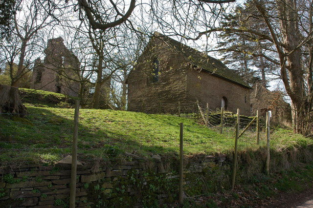
Urishay Castle Chapel
Urishay Castle Chapel is a redundant chapel to the north of Urishay Castle, some 2.5 kilometres (2 mi) west of the village of Peterchurch in Herefordshire...
Craswall
Craswall (historically also spelt Craswell, Crasswall and Crosswold) is a village and civil parish in Herefordshire, England. It lies in the far west...

Newton, Golden Valley
Newton is a village and civil parish 11 miles (18 km) south west of Hereford, in the county of Herefordshire, England. In 2011 the parish had a population...
Llanveynoe
Llanveynoe (Welsh: Llanfeuno) is a village and civil parish in Herefordshire, England, near the Welsh border and the Brecon Beacons National Park, 14 miles...
Nearby Amenities
Located within 500m of 52.010021,-2.9985057Have you been to Bank Wood?
Leave your review of Bank Wood below (or comments, questions and feedback).