Lilymoor Copse

Wood, Forest in Dorset South Somerset

England

Lilymoor Copse

Crossroads between Chard and Wambrook, known locally as Red Post looking north along Palfrey's Lane
Crossroads between Chard and Wambrook, known locally as Red Post Credit: Andrew Longton

Lilymoor Copse is a picturesque woodland area located in the county of Dorset, England. Situated near the village of Lilymoor, this copse is renowned for its natural beauty and tranquil atmosphere.

Covering an area of approximately 50 acres, Lilymoor Copse is predominantly made up of broadleaf trees, including oak, beech, and ash. The dense foliage provides a lush habitat for a variety of wildlife, making it a popular destination for nature enthusiasts and bird watchers. Visitors can expect to see a plethora of bird species, such as woodpeckers, nuthatches, and tawny owls, as well as small mammals like squirrels and hedgehogs.

The copse is intersected by several footpaths, allowing visitors to explore its enchanting surroundings on foot. As they meander through the woodland, visitors will come across babbling brooks, charming wildflower meadows, and secluded clearings, which provide perfect picnic spots or peaceful areas for reflection.

Lilymoor Copse is also home to a diverse range of plant species, with bluebells and primroses carpeting the forest floor in the spring, creating a vibrant and colorful display. In addition, the copse is known for its ancient trees, some of which are estimated to be over 200 years old, adding a sense of history and grandeur to the area.

Overall, Lilymoor Copse offers a serene escape from the hustle and bustle of everyday life, providing visitors with an opportunity to immerse themselves in the beauty of nature and experience the tranquility of an authentic Dorset woodland.

If you have any feedback on the listing, please let us know in the comments section below.

Lilymoor Copse Images

Images are sourced within 2km of 50.862673/-3.0104795 or Grid Reference ST2807. Thanks to Geograph Open Source API. All images are credited.

Crossroads between Chard and Wambrook, known locally as Red Post looking north along Palfrey's Lane
Crossroads between Chard and Wambrook, known locally as Red Post
looking north along Palfrey's Lane
Wambrook: field near Four Gates Looking south-south-west. A public footpath runs on the far side of the hedge on the left
Wambrook: field near Four Gates
Looking south-south-west. A public footpath runs on the far side of the hedge on the left
Wambrook: landscape near Four Gates Stubble field and cloud. Looking east-north-east by a public footpath to Snowdon Farm, Chard
Wambrook: landscape near Four Gates
Stubble field and cloud. Looking east-north-east by a public footpath to Snowdon Farm, Chard
Wambrook: Green Lane By the entrance to Cotley – behind the camera – looking south-south-east
Wambrook: Green Lane
By the entrance to Cotley – behind the camera – looking south-south-east
The Red Post, between Chard and Wambrook Unusual to see a red signpost like this.
The Red Post, between Chard and Wambrook
Unusual to see a red signpost like this.
Farthing Lane County boundary follows this track to Burridge Common.
Farthing Lane
County boundary follows this track to Burridge Common.
Narfords Lane The county boundary follows this lane to Narfords.
Narfords Lane
The county boundary follows this lane to Narfords.
Huntley Lane Leading to Huntley Farm.
Huntley Lane
Leading to Huntley Farm.
Green Lane Leading to Dennetts Farm.
Green Lane
Leading to Dennetts Farm.
Public footpath signpost In need of a little care and attention.
Public footpath signpost
In need of a little care and attention.
North on Green Lane Typical Somerset lane.
North on Green Lane
Typical Somerset lane.
Local traffic on Green Lane
Cotley Lane
Cotley Lane
Route to Chard Fingerpost and stile on public footpath CH 25/UN.
Route to Chard
Fingerpost and stile on public footpath CH 25/UN.
Red Post Another view including the red signpost shown in <a title="https://www.geograph.org.uk/search.php?i=41613831" href="https://www.geograph.org.uk/search.php?i=41613831">Link</a> , and with a pony and trap heading towards Wambrook (location of the Cotley Inn, advertised by the brown sign). It's a lovely day, but the puddle on the left indicates recent rain.
Red Post
Another view including the red signpost shown in Link , and with a pony and trap heading towards Wambrook (location of the Cotley Inn, advertised by the brown sign). It's a lovely day, but the puddle on the left indicates recent rain.
Gate at Red Post On the north side of the crossroads shown in <a href="https://www.geograph.org.uk/photo/3467571">ST3008 : Red Post</a>, with gentle countryside visible through the gate. Palfreys Lane, on the left, is an exceedingly narrow lane to the A30.
Gate at Red Post
On the north side of the crossroads shown in ST3008 : Red Post, with gentle countryside visible through the gate. Palfreys Lane, on the left, is an exceedingly narrow lane to the A30.
Red Post Another view of the post seen in <a title="https://www.geograph.org.uk/search.php?i=41614263" href="https://www.geograph.org.uk/search.php?i=41614263">Link</a> .
Red Post
Another view of the post seen in Link .
Field entrance, Narfords Lane Through a narrow belt of trees alongside the lane between two right-angled bends. The view looks towards the Kit valley.
Field entrance, Narfords Lane
Through a narrow belt of trees alongside the lane between two right-angled bends. The view looks towards the Kit valley.
Show me another place!

Lilymoor Copse is located at Grid Ref: ST2807 (Lat: 50.862673, Lng: -3.0104795)

Administrative County: Somerset

District: South Somerset

Police Authority: Avon and Somerset

What 3 Words

///heightens.sprinter.able. Near Chard, Somerset

Nearby Locations

Lilymoor Copse

Related Wikis

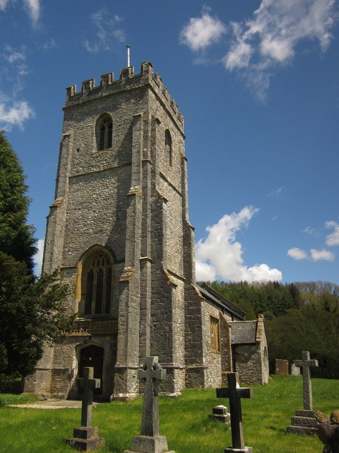
Church of St Mary, Wambrook

The Anglican Church of St Mary in Wambrook, Somerset, England, was built in the 13th century. It is a Grade II* listed building. == History == The church...

Wambrook

Wambrook is a village and civil parish in the Blackdown Hills, Somerset, England. The village lies about 2 miles (3 km) southwest of the town of Chard...

Holy City, Devon

Holy City is a hamlet in the parish of Chardstock, East Devon, England. It is approximately 5 miles (8.0 km) due north of the town of Axminster, and 4...

Snowdon Hill Quarry

Snowdon Hill Quarry (grid reference ST312089) is a 0.6 hectare geological Site of Special Scientific Interest on the western outskirts of Chard in Somerset...

Horse Pool Camp

Horse Pool Camp is a univallate Iron Age hill fort enclosure in the South Somerset district of Somerset, England. It is also known as Whitestaunton Camp...

St Andrew's Church, Whitestaunton

The Church of St Andrew in Whitestaunton, Somerset, England, dates from the 13th century and has been designated as a Grade I listed building.The Perpendicular...

Whitestaunton

Whitestaunton is a village and civil parish in the South Somerset district of Somerset, England. The parish includes the hamlet of Northay. It was known...
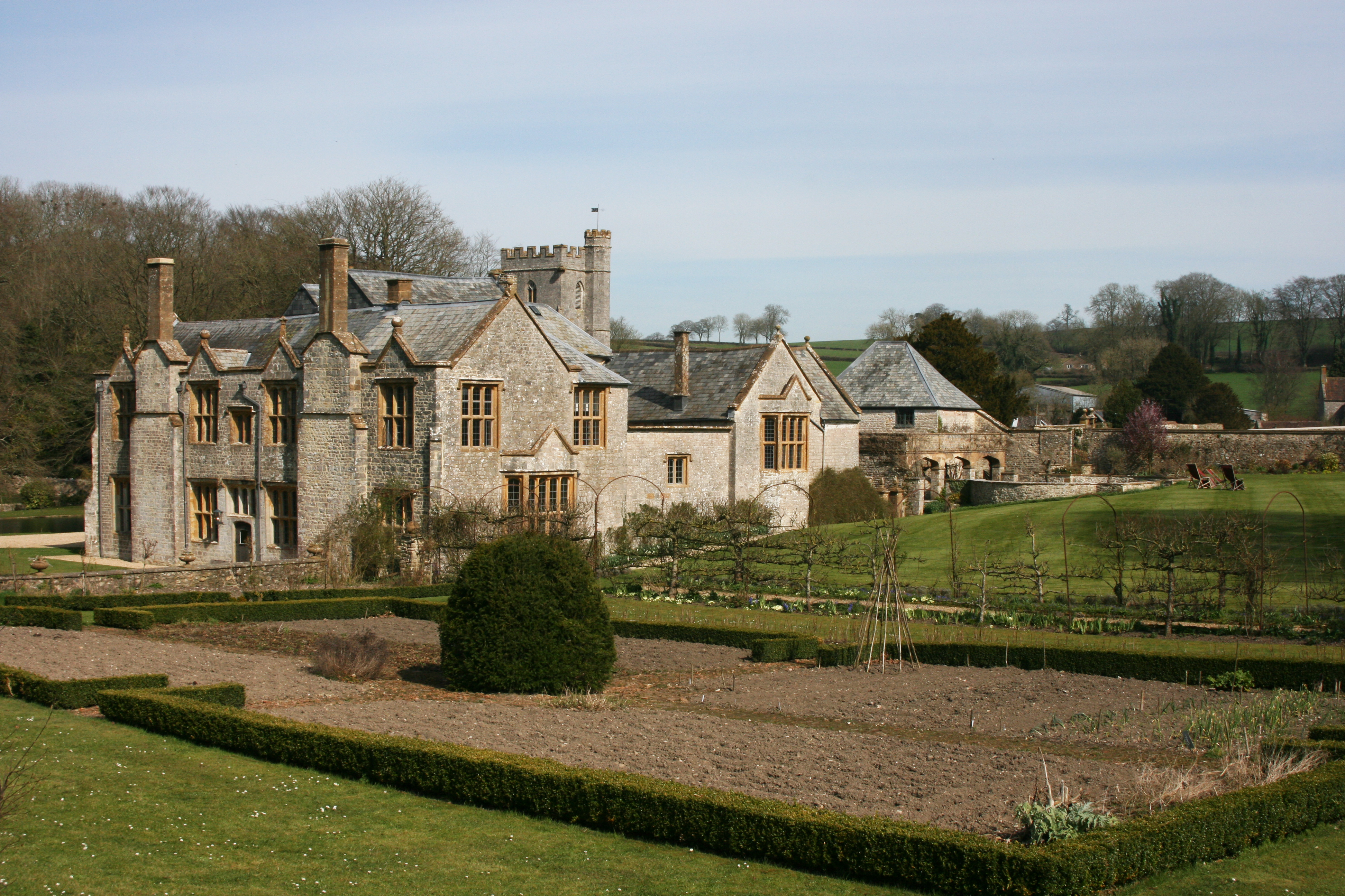
Whitestaunton Manor

Whitestaunton Manor in the village of Whitestaunton, Somerset, England was built in the 15th century as a Hall house and has been designated as a Grade...

Nearby Amenities

Located within 500m of 50.862673,-3.0104795
Wambrook
Place: hamlet
Lat/Long: 50.8623849/-3.0046197
Post Box
Operator: Royal Mail
Operator Wikidata: Q638098
Royal Cypher: EIIR
Royal Cypher Wikidata: Q33102113
Lat/Long: 50.8648506/-3.0053182
Power: pole
Source: bing
Lat/Long: 50.8584305/-3.0104283
Power: pole
Source: bing
Lat/Long: 50.8586489/-3.0103961
Power: pole
Source: bing
Lat/Long: 50.8591297/-3.01038
Power: pole
Source: bing
Lat/Long: 50.859851/-3.0103397
Power: pole
Source: bing
Lat/Long: 50.861952/-3.0038193
Power: pole
Source: bing
Transformer: distribution
Lat/Long: 50.8624091/-3.0049485
Power: pole
Source: bing
Transformer: distribution
Lat/Long: 50.865756/-3.0057639
Power: pole
Source: bing
Lat/Long: 50.8656967/-3.0059865
Power: pole
Source: bing
Lat/Long: 50.8650653/-3.0059919
Power: pole
Source: bing
Lat/Long: 50.8638498/-3.0059516
Power: pole
Source: bing
Lat/Long: 50.8645388/-3.0059758
Power: pole
Source: bing
Lat/Long: 50.8631049/-3.0046105
Power: pole
Source: bing
Lat/Long: 50.8630203/-3.0049807
Power: pole
Source: bing
Lat/Long: 50.8628053/-3.0059087
Power: pole
Source: bing
Lat/Long: 50.8626631/-3.0063325
Power: pole
Source: bing
Lat/Long: 50.8623516/-3.0073839
Power: pole
Source: bing
Lat/Long: 50.860678/-3.0102901
Power: pole
Source: bing
Lat/Long: 50.8620147/-3.0085051
Power: pole
Source: bing
Lat/Long: 50.8616286/-3.009814
Power: pole
Source: bing
Transformer: distribution
Lat/Long: 50.8617116/-3.0109888
Power: pole
Source: bing
Lat/Long: 50.8617759/-3.0118471
Power: pole
Source: bing
Lat/Long: 50.8618454/-3.0128932
Power: pole
Source: bing
Lat/Long: 50.8619198/-3.0138373
Power: pole
Source: bing
Lat/Long: 50.8619876/-3.0148512
Power: pole
Source: bing
Lat/Long: 50.8620367/-3.0155164
Power: pole
Source: bing
Lat/Long: 50.8622483/-3.0166349
The data included in this document is from www.openstreetmap.org. The data is made available under ODbL.

Have you been to Lilymoor Copse?

Leave your review of Lilymoor Copse below (or comments, questions and feedback).