Nant Wood

Wood, Forest in Shropshire

England

Nant Wood

Country road in winter Heading west and uphill from Pentre Dafydd.
Country road in winter Credit: John H Darch

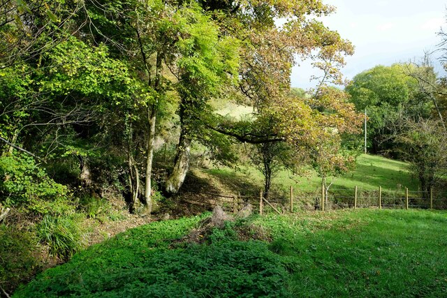
Nant Wood is a beautiful wooded area located in Shropshire, England. The wood covers approximately 12 hectares and is a popular destination for nature lovers and outdoor enthusiasts. The wood is home to a variety of tree species, including oak, ash, and beech, as well as a diverse range of wildlife such as deer, squirrels, and birds.

Visitors to Nant Wood can enjoy peaceful walks along well-maintained trails that wind through the forest, providing opportunities to observe the flora and fauna up close. The wood also features a small stream that adds to the tranquil ambiance of the area.

Nant Wood is a designated Site of Special Scientific Interest (SSSI) due to its importance as a habitat for rare and endangered species. Conservation efforts are in place to protect the delicate ecosystem of the wood and ensure its preservation for future generations to enjoy.

Overall, Nant Wood is a picturesque and tranquil destination for those seeking to connect with nature and experience the beauty of the Shropshire countryside.

If you have any feedback on the listing, please let us know in the comments section below.
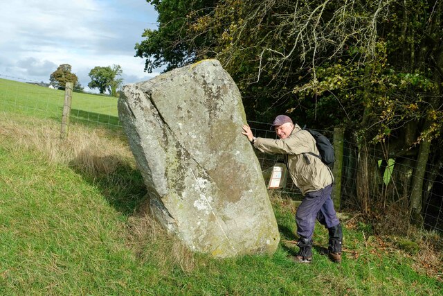
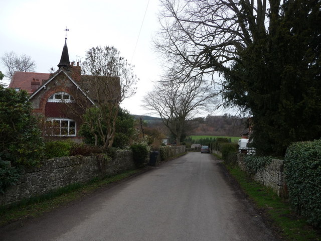
Nant Wood Images

Images are sourced within 2km of 52.899643/-3.0924296 or Grid Reference SJ2634. Thanks to Geograph Open Source API. All images are credited.

Country road in winter Heading west and uphill from Pentre Dafydd.
Country road in winter
Heading west and uphill from Pentre Dafydd.
Drainage ditch after February rain
Field near Mardy
Field near Mardy
Ordnance Survey Flush Bracket (G3019) This OS Flush Bracket can be found on The Cross Keys Inn. It marks a point 232.528m above mean sea level.
Ordnance Survey Flush Bracket (G3019)
This OS Flush Bracket can be found on The Cross Keys Inn. It marks a point 232.528m above mean sea level.
Ordnance Survey Pivot This OS pivot can be found on the south face of St Mary's Church. It marks a point 231.359m above mean sea level.
Ordnance Survey Pivot
This OS pivot can be found on the south face of St Mary's Church. It marks a point 231.359m above mean sea level.
Mile Stone - Oswestry 4 There is an OS cut mark on the stone which marks a point 255.691m above mean sea level.
Mile Stone - Oswestry 4
There is an OS cut mark on the stone which marks a point 255.691m above mean sea level.
Offa's Dyke Path north of Craignant Heading south along Offa's Dyke Path towards Craignant.

Wikipedia <span class="nowrap"><a title="https://en.wikipedia.org/wiki/Offa%27s_Dyke_Path" rel="nofollow ugc noopener" href="https://en.wikipedia.org/wiki/Offa%27s_Dyke_Path">Link</a><img style="margin-left:2px;" alt="External link" title="External link - shift click to open in new window" src="https://s1.geograph.org.uk/img/external.png" width="10" height="10"/></span>
Offa's Dyke Path north of Craignant
Heading south along Offa's Dyke Path towards Craignant. Wikipedia LinkExternal link
At Craignant A scene from Offa's Dyke Path at Craignant.

Wikipedia <span class="nowrap"><a title="https://en.wikipedia.org/wiki/Offa%27s_Dyke_Path" rel="nofollow ugc noopener" href="https://en.wikipedia.org/wiki/Offa%27s_Dyke_Path">Link</a><img style="margin-left:2px;" alt="External link" title="External link - shift click to open in new window" src="https://s1.geograph.org.uk/img/external.png" width="10" height="10"/></span>
At Craignant
A scene from Offa's Dyke Path at Craignant. Wikipedia LinkExternal link
Offa's Dyke Path south of Craignant Heading south along Offa's Dyke Path near Selattyn Hill south of Craignant.

Wikipedia <span class="nowrap"><a title="https://en.wikipedia.org/wiki/Offa%27s_Dyke_Path" rel="nofollow ugc noopener" href="https://en.wikipedia.org/wiki/Offa%27s_Dyke_Path">Link</a><img style="margin-left:2px;" alt="External link" title="External link - shift click to open in new window" src="https://s1.geograph.org.uk/img/external.png" width="10" height="10"/></span>
Offa's Dyke Path south of Craignant
Heading south along Offa's Dyke Path near Selattyn Hill south of Craignant. Wikipedia LinkExternal link
Rowan Tree next to Offa's Dyke A rowan tree next to Offa's Dyke just south of Selattyn Hill.

Wikipedia <span class="nowrap"><a title="https://en.wikipedia.org/wiki/Offa%27s_Dyke_Path" rel="nofollow ugc noopener" href="https://en.wikipedia.org/wiki/Offa%27s_Dyke_Path">Link</a><img style="margin-left:2px;" alt="External link" title="External link - shift click to open in new window" src="https://s1.geograph.org.uk/img/external.png" width="10" height="10"/></span>
Rowan Tree next to Offa's Dyke
A rowan tree next to Offa's Dyke just south of Selattyn Hill. Wikipedia LinkExternal link
Offa's Dyke Path West of Selattyn Looking north along Offa's Dyke Path West of Selattyn near the England/Wales border.
Although now in Shropshire, this area only became confirmed as part of England in the 16th century, and as recently as 1878 Welsh services and Welsh was reportedly being spoken in Selattyn and the surrounding area.

Wikipedia <span class="nowrap"><a title="https://en.wikipedia.org/wiki/Offa%27s_Dyke_Path" rel="nofollow ugc noopener" href="https://en.wikipedia.org/wiki/Offa%27s_Dyke_Path">Link</a><img style="margin-left:2px;" alt="External link" title="External link - shift click to open in new window" src="https://s1.geograph.org.uk/img/external.png" width="10" height="10"/></span>
Offa's Dyke Path West of Selattyn
Looking north along Offa's Dyke Path West of Selattyn near the England/Wales border. Although now in Shropshire, this area only became confirmed as part of England in the 16th century, and as recently as 1878 Welsh services and Welsh was reportedly being spoken in Selattyn and the surrounding area. Wikipedia LinkExternal link
Heading south along Offa's Dyke Path Heading south along Offa's Dyke Path west of Selattyn. The dyke itself can be seen to the right of the path.
Although now in Shropshire, this area only became confirmed as part of England in the 16th century, and as recently as 1878 Welsh services and Welsh was reportedly being spoken in Selattyn and the surrounding area.

Wikipedia <span class="nowrap"><a title="https://en.wikipedia.org/wiki/Offa%27s_Dyke_Path" rel="nofollow ugc noopener" href="https://en.wikipedia.org/wiki/Offa%27s_Dyke_Path">Link</a><img style="margin-left:2px;" alt="External link" title="External link - shift click to open in new window" src="https://s1.geograph.org.uk/img/external.png" width="10" height="10"/></span>
Heading south along Offa's Dyke Path
Heading south along Offa's Dyke Path west of Selattyn. The dyke itself can be seen to the right of the path. Although now in Shropshire, this area only became confirmed as part of England in the 16th century, and as recently as 1878 Welsh services and Welsh was reportedly being spoken in Selattyn and the surrounding area. Wikipedia LinkExternal link
Looking north along Offa's Dyke Path Looking north along Offa's Dyke Path west of Selattyn. The dyke itself can be seen to the left of the path.
Although now in Shropshire, this area only became confirmed as part of England in the 16th century, and as recently as 1878 Welsh services and Welsh was reportedly being spoken in Selattyn and the surrounding area.

Wikipedia <span class="nowrap"><a title="https://en.wikipedia.org/wiki/Offa%27s_Dyke_Path" rel="nofollow ugc noopener" href="https://en.wikipedia.org/wiki/Offa%27s_Dyke_Path">Link</a><img style="margin-left:2px;" alt="External link" title="External link - shift click to open in new window" src="https://s1.geograph.org.uk/img/external.png" width="10" height="10"/></span>
Looking north along Offa's Dyke Path
Looking north along Offa's Dyke Path west of Selattyn. The dyke itself can be seen to the left of the path. Although now in Shropshire, this area only became confirmed as part of England in the 16th century, and as recently as 1878 Welsh services and Welsh was reportedly being spoken in Selattyn and the surrounding area. Wikipedia LinkExternal link
Along the edge of the woods on Offa's Dyke Path Heading south along the edge of woodland on Offa's Dyke Path southwest of Selattyn.
Although now in Shropshire, this area only became confirmed as part of England in the 16th century, and as recently as 1878 Welsh services and Welsh was reportedly being spoken in Selattyn and the surrounding area.

Wikipedia <span class="nowrap"><a title="https://en.wikipedia.org/wiki/Offa%27s_Dyke_Path" rel="nofollow ugc noopener" href="https://en.wikipedia.org/wiki/Offa%27s_Dyke_Path">Link</a><img style="margin-left:2px;" alt="External link" title="External link - shift click to open in new window" src="https://s1.geograph.org.uk/img/external.png" width="10" height="10"/></span>
Along the edge of the woods on Offa's Dyke Path
Heading south along the edge of woodland on Offa's Dyke Path southwest of Selattyn. Although now in Shropshire, this area only became confirmed as part of England in the 16th century, and as recently as 1878 Welsh services and Welsh was reportedly being spoken in Selattyn and the surrounding area. Wikipedia LinkExternal link
Carreg y Big (The Big Stone), Selattyn Carreg y Big near the village of Selattyn and not far from Offa's Dyke is an example of a hoarstone, or boundary stone. At 2m tall, Carreg-y-Big is probably Shropshire’s tallest standing stone.

The size of the stone can look deceptively small in photos, so here's a humorous rambler to help compare size <a href="https://www.geograph.org.uk/photo/7412180">SJ2532 : Carreg y Big (The Big Stone), Selattyn</a>
Carreg y Big (The Big Stone), Selattyn
Carreg y Big near the village of Selattyn and not far from Offa's Dyke is an example of a hoarstone, or boundary stone. At 2m tall, Carreg-y-Big is probably Shropshire’s tallest standing stone. The size of the stone can look deceptively small in photos, so here's a humorous rambler to help compare size SJ2532 : Carreg y Big (The Big Stone), Selattyn
Carreg y Big (The Big Stone), Selattyn Carreg y Big near the village of Selattyn and not far from Offa's Dyke is an example of a hoarstone, or boundary stone. At 2m tall, Carreg-y-Big is probably Shropshire’s tallest standing stone.

Without the humorous rambler the stone can look deceptively small <a href="https://www.geograph.org.uk/photo/7412179">SJ2532 : Carreg y Big (The Big Stone), Selattyn</a>
Carreg y Big (The Big Stone), Selattyn
Carreg y Big near the village of Selattyn and not far from Offa's Dyke is an example of a hoarstone, or boundary stone. At 2m tall, Carreg-y-Big is probably Shropshire’s tallest standing stone. Without the humorous rambler the stone can look deceptively small SJ2532 : Carreg y Big (The Big Stone), Selattyn
Carreg y Big (The Big Stone), Selattyn Carreg y Big near the village of Selattyn and not far from Offa's Dyke is an example of a hoarstone, or boundary stone. At 2m tall, Carreg-y-Big is probably Shropshire’s tallest standing stone.

The size of the stone can look deceptively small in photos, so here's a humorous rambler to help compare size <a href="https://www.geograph.org.uk/photo/7412180">SJ2532 : Carreg y Big (The Big Stone), Selattyn</a>
Carreg y Big (The Big Stone), Selattyn
Carreg y Big near the village of Selattyn and not far from Offa's Dyke is an example of a hoarstone, or boundary stone. At 2m tall, Carreg-y-Big is probably Shropshire’s tallest standing stone. The size of the stone can look deceptively small in photos, so here's a humorous rambler to help compare size SJ2532 : Carreg y Big (The Big Stone), Selattyn
Farmhouse at Craignant
Show me another place!

Nant Wood is located at Grid Ref: SJ2634 (Lat: 52.899643, Lng: -3.0924296)

Unitary Authority: Shropshire

Police Authority: West Mercia

What 3 Words

///fluffed.already.cupboards. Near Gobowen, Shropshire

Nearby Locations

Nant Wood

Related Wikis

Selattyn and Gobowen

Selattyn and Gobowen is a civil parish in Shropshire, England. The civil parish population at the 2011 census was 4,016. == See also == Listed buildings...

Selattyn

Selattyn (Welsh: Sylatyn) is a village and former civil parish, now in the parish of Selattyn and Gobowen, in the Shropshire district, in the ceremonial...

Weston Rhyn

Weston Rhyn is a large village and civil parish in Shropshire, England. It lies between the towns of Chirk, in Wales, and Oswestry, in England. The civil...

Bronygarth

Bronygarth is a small village in the Ceiriog Valley near Oswestry in Shropshire, England at grid reference SJ268370. The village is on the England–Wales...

Nearby Amenities

Located within 500m of 52.899643,-3.0924296
Selattyn
Is In: Shropshire
Name Cy: Selatyn
Place: village
Source: npe
Lat/Long: 52.8985827/-3.0893738
Pub
The Docks
Addr City: Oswestry
Addr Country: GB
Addr Hamlet: Selattyn
Addr Postcode: SY10 7DH
Addr Street: Glyn Road
Fhrs Authority: Shropshire
Fhrs Id: 1246789
Fhrs Local Authority Id: 20/00033/COMM
Lat/Long: 52.8984856/-3.0912916
Building: yes
Lat/Long: 52.8952683/-3.0919177
Building: yes
Lat/Long: 52.9033854/-3.091581
Public Bookcase
Community Library
Defibrillator
Booth: K6
Colour: red
Defibrillator Location: inside red telephone box (that is now a community library) near Cross Keys pub in Selattyn
Disused Amenity: telephone
Emergency: defibrillator
Man Made: telephone_box
Public Bookcase Type: phone_box
Lat/Long: 52.898384/-3.0908495
Post Box
Post Box Type: lamp
Lat/Long: 52.8983734/-3.0916574
Bench
Lat/Long: 52.8983904/-3.0916366
Give Way
Direction: forward
Lat/Long: 52.9028089/-3.0918572
Give Way
Direction: backward
Lat/Long: 52.8975518/-3.0870794
The data included in this document is from www.openstreetmap.org. The data is made available under ODbL.

Have you been to Nant Wood?

Leave your review of Nant Wood below (or comments, questions and feedback).