Bridgwater Plantation

Wood, Forest in Somerset Somerset West and Taunton

England

Bridgwater Plantation

Pitminster : Blackdown Hill Looking along the road.
Pitminster : Blackdown Hill Credit: Lewis Clarke

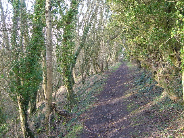
Bridgwater Plantation is a picturesque woodland area located in Somerset, England. Covering an expansive area of approximately 500 acres, the plantation is known for its lush greenery, diverse wildlife, and tranquil atmosphere. It is situated near the town of Bridgwater, making it easily accessible to both locals and tourists.

The plantation is predominantly made up of a dense forest, consisting of several species of trees including oak, beech, and pine. These towering trees create a rich canopy that provides shade and shelter to the various animals that call this place home. The woodland is also interspersed with well-maintained walking trails, allowing visitors to explore and enjoy the natural beauty of the area.

Bridgwater Plantation is a haven for nature enthusiasts and birdwatchers, as it provides a habitat for a wide array of bird species. Visitors can spot birds such as woodpeckers, owls, and various songbirds, as they flit through the trees and sing their melodious tunes.

The plantation is also home to numerous mammals, including deer, foxes, and rabbits, which can often be seen grazing or foraging in the undergrowth. Additionally, the plantation has a diverse ecosystem of insects, promoting biodiversity and ecological balance.

Bridgwater Plantation offers a peaceful escape from the hustle and bustle of everyday life. Whether it's taking a leisurely stroll along the trails, enjoying a picnic amidst the beautiful surroundings, or simply immersing oneself in the serenity of nature, this woodland plantation is a perfect destination for nature lovers seeking solace and tranquility.

If you have any feedback on the listing, please let us know in the comments section below.

Bridgwater Plantation Images

Images are sourced within 2km of 50.942227/-3.1259016 or Grid Reference ST2016. Thanks to Geograph Open Source API. All images are credited.

Pitminster : Blackdown Hill Looking along the road.
Pitminster : Blackdown Hill
Looking along the road.
Pitminster : Blackdown Hill Looking along Blackdown Hill.
Pitminster : Blackdown Hill
Looking along Blackdown Hill.
Pitminster : Track A track heading off Blackdown Hill to Sheep Wash.
Pitminster : Track
A track heading off Blackdown Hill to Sheep Wash.
Pitminster: road by Mount Pleasant This route links Wellington with the A303 at Yarcombe and for much of its length runs in a series of straight sections. The bends at Mount Pleasant are untypical. Looking east-south-east
Pitminster: road by Mount Pleasant
This route links Wellington with the A303 at Yarcombe and for much of its length runs in a series of straight sections. The bends at Mount Pleasant are untypical. Looking east-south-east
Churchstanton: Trickey Warren Lane A public bridleway. Looking east-south-east
Churchstanton: Trickey Warren Lane
A public bridleway. Looking east-south-east
Farmland from Luxhay
Carp in Leigh Hill Reservoir
Leigh Hill Reservoir Constructed in the 1890's.
Leigh Hill Reservoir
Constructed in the 1890's.
Leigh Hill Reservoir Constructed in the 1890's.
Leigh Hill Reservoir
Constructed in the 1890's.
Leigh Hill Reservoir - plaque
Leigh Hill Reservoir Built in the 1890's.
Leigh Hill Reservoir
Built in the 1890's.
Bagbear's Farm The farm, which is in the well-wooded upper valley of the River Culm, seen across a field from the lane up the valley from Churchstanton.
Bagbear's Farm
The farm, which is in the well-wooded upper valley of the River Culm, seen across a field from the lane up the valley from Churchstanton.
Field boundary near Bagbear's Farm Trees line a bank beside a shallow ditch. The nearest trees can be seen on the right of <a href="https://www.geograph.org.uk/photo/1677411">ST1915 : Bagbear's Farm</a>, taken at the same place.
Field boundary near Bagbear's Farm
Trees line a bank beside a shallow ditch. The nearest trees can be seen on the right of ST1915 : Bagbear's Farm, taken at the same place.
Strawbridge's Farm The farm is at a lane junction just above the upper River Culm.
Strawbridge's Farm
The farm is at a lane junction just above the upper River Culm.
Field, Culm valley The meadow slopes down to the River Culm, here in its infancy about 2 kilometres from its source, from the lane between <a href="https://www.geograph.org.uk/photo/1677460">ST1916 : Strawbridge's Farm</a> and the crest of the Blackdowns near Gorse Cottage.
Field, Culm valley
The meadow slopes down to the River Culm, here in its infancy about 2 kilometres from its source, from the lane between ST1916 : Strawbridge's Farm and the crest of the Blackdowns near Gorse Cottage.
Field and track near Westcombe A field on the other side of the lane from <a href="https://www.geograph.org.uk/photo/1677491">ST1916 : Field, Culm valley</a>, with an unnamed plantation to its right.
Field and track near Westcombe
A field on the other side of the lane from ST1916 : Field, Culm valley, with an unnamed plantation to its right.
Field boundary, Westcombe Bank, trees and barbed wire fence along ditch provide a multiple barrier running at right angles to the lane northeast of Strawbridge's Farm.
Field boundary, Westcombe
Bank, trees and barbed wire fence along ditch provide a multiple barrier running at right angles to the lane northeast of Strawbridge's Farm.
Double bend, Mount Pleasant According to <span class="nowrap"><a title="http://webapp1.somerset.gov.uk/her/details.asp?prn=26698" rel="nofollow ugc noopener" href="http://webapp1.somerset.gov.uk/her/details.asp?prn=26698">Link</a><img style="margin-left:2px;" alt="External link" title="External link - shift click to open in new window" src="https://s1.geograph.org.uk/img/external.png" width="10" height="10"/></span> , the road follows the ancient Blackdown Hills Ridgeway. This is taken on the bend shown in <a href="https://www.geograph.org.uk/photo/173646">ST1916 : Pitminster: road by Mount Pleasant</a>, looking in the same direction.
Double bend, Mount Pleasant
According to LinkExternal link , the road follows the ancient Blackdown Hills Ridgeway. This is taken on the bend shown in ST1916 : Pitminster: road by Mount Pleasant, looking in the same direction.
Show me another place!

Bridgwater Plantation is located at Grid Ref: ST2016 (Lat: 50.942227, Lng: -3.1259016)

Administrative County: Somerset

District: Somerset West and Taunton

Police Authority: Avon and Somerset

What 3 Words

///cowering.measures.prosper. Near Hemyock, Devon

Related Wikis

Luxhay Reservoir

Luxhay Reservoir is an artificial reservoir near Angersleigh, Somerset, England. It is now owned by Wessex Water. It was built in 1905 by the town corporation...

RAF Culmhead

Royal Air Force Culmhead or more simply RAF Culmhead is a former Royal Air Force station, situated at Churchstanton on the Blackdown Hills in Somerset...

Prior's Park & Adcombe Wood

Prior's Park & Adcombe Wood (grid reference ST225170) is a 103.6 hectare (256.0 acre) biological Site of Special Scientific Interest south of Pitminster...

Leigh Reservoir

Leigh Reservoir, or Leigh Hill Reservoir, is a small reservoir in Somerset, England. It was built in 1893 to supply water to the town of Taunton, Somerset...

Churchstanton

Churchstanton is a village and civil parish in Somerset, England, situated within the Blackdown Hills Area of Outstanding Natural Beauty, on the River...

Church of St Michael, Angersleigh

The Anglican Church of St Michael in Angersleigh, Somerset, England was built in the 14th century. It is a Grade II* listed building. == History == The...

Church of St Leonard, Otterford

The Anglican Church of St Leonard in Otterford, Somerset, England was built in the 14th century. It is a Grade II* listed building. == History == The church...

Otterford

Otterford is a village and civil parish in Somerset, England. It is situated on the Blackdown Hills, 7 miles (11.3 km) south of Taunton. The village has...

Nearby Amenities

Located within 500m of 50.942227,-3.1259016
Brand: National Grid
Brand Wikidata: Q1465461
Material: wood
Operator: National Grid Electricity Distribution Plc
Operator Old: Western Power Distribution
Operator Wikidata: Q7988183
Owner: National Grid Electricity Distribution (South West) Plc
Owner Wikidata: Q114397866
Power: pole
Lat/Long: 50.9465904/-3.124449
Brand: National Grid
Brand Wikidata: Q1465461
Material: wood
Operator: National Grid Electricity Distribution Plc
Operator Old: Western Power Distribution
Operator Wikidata: Q7988183
Owner: National Grid Electricity Distribution (South West) Plc
Owner Wikidata: Q114397866
Power: pole
Lat/Long: 50.9463927/-3.1259751
Brand: National Grid
Brand Wikidata: Q1465461
Material: wood
Operator: National Grid Electricity Distribution Plc
Operator Old: Western Power Distribution
Operator Wikidata: Q7988183
Owner: National Grid Electricity Distribution (South West) Plc
Owner Wikidata: Q114397866
Power: pole
Lat/Long: 50.9451185/-3.1296632
Brand: National Grid
Brand Wikidata: Q1465461
Material: wood
Operator: National Grid Electricity Distribution Plc
Operator Old: Western Power Distribution
Operator Wikidata: Q7988183
Owner: National Grid Electricity Distribution (South West) Plc
Owner Wikidata: Q114397866
Power: pole
Lat/Long: 50.9448362/-3.1314093
The data included in this document is from www.openstreetmap.org. The data is made available under ODbL.

Have you been to Bridgwater Plantation?

Leave your review of Bridgwater Plantation below (or comments, questions and feedback).