Bagbear's Cleeve Plantation

Wood, Forest in Devon Somerset West and Taunton

England

Bagbear's Cleeve Plantation

Pitminster : Woodland Woodland seen off Blackdown Hill.
Pitminster : Woodland Credit: Lewis Clarke

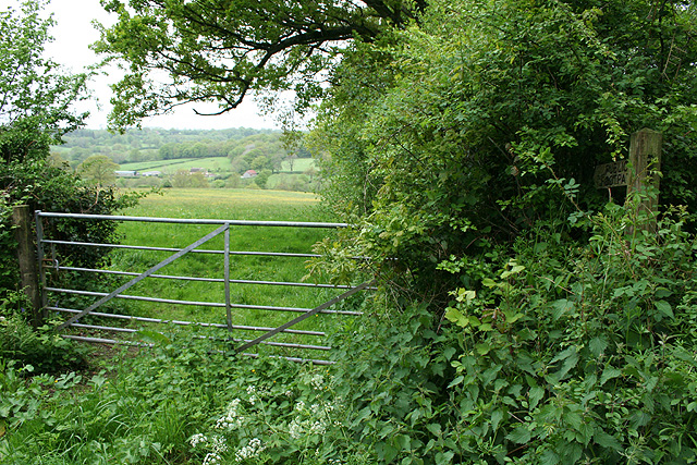
Bagbear's Cleeve Plantation is a picturesque woodland located in Devon, England. Covering an area of approximately 200 acres, this enchanting forest is nestled within the stunning landscape of the county. The plantation is part of the larger Bagbear's Cleeve Estate and is renowned for its diverse range of tree species and flourishing wildlife.

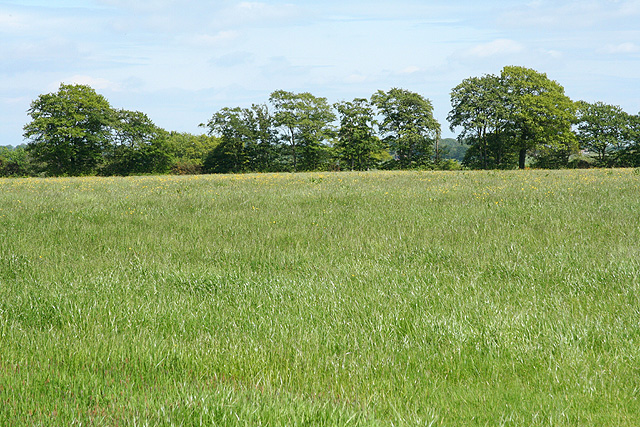
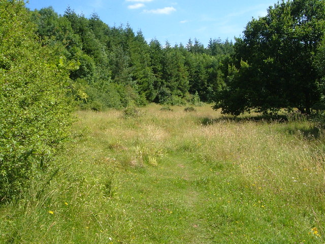
The woodland is primarily composed of native English trees, including oak, beech, and birch. These majestic trees create a dense canopy that provides shade and shelter for a rich variety of plant and animal life. Walking through the plantation, visitors are greeted by a carpet of wildflowers, such as bluebells and foxgloves, which bloom in vibrant colors during the spring and summer months.

Bagbear's Cleeve Plantation is a haven for wildlife enthusiasts, offering a sanctuary for numerous species. The forest is home to a variety of birds, including woodpeckers, owls, and songbirds, which can be heard singing their melodious tunes throughout the day. Deer and badgers can also be spotted roaming the forest floor, adding to the sense of natural beauty and tranquility.

The plantation is open for public access, providing an ideal location for walking, hiking, and nature exploration. Well-maintained trails wind through the woodland, allowing visitors to immerse themselves in the peaceful surroundings. Nature lovers can enjoy the sights and sounds of the forest while taking in breathtaking views of the surrounding Devonshire countryside.

Bagbear's Cleeve Plantation is a truly captivating destination, offering a combination of natural beauty, biodiversity, and recreational opportunities. It is a must-visit location for anyone seeking to connect with nature and experience the tranquility of an ancient woodland.

If you have any feedback on the listing, please let us know in the comments section below.

Bagbear's Cleeve Plantation Images

Images are sourced within 2km of 50.932887/-3.1403907 or Grid Reference ST1915. Thanks to Geograph Open Source API. All images are credited.

Pitminster : Woodland Woodland seen off Blackdown Hill.
Pitminster : Woodland
Woodland seen off Blackdown Hill.
Pitminster : Blackdown Hill Looking along the road.
Pitminster : Blackdown Hill
Looking along the road.
Pitminster : Blackdown Hill Looking along Blackdown Hill.
Pitminster : Blackdown Hill
Looking along Blackdown Hill.
Pitminster : Track A track heading off Blackdown Hill to Sheep Wash.
Pitminster : Track
A track heading off Blackdown Hill to Sheep Wash.
Churchstanton:  church of St Peter and St Paul Tower of the parish church seen from the north west
Churchstanton: church of St Peter and St Paul
Tower of the parish church seen from the north west
Churchstanton: lane to Court Farm Looking west-north-west
Churchstanton: lane to Court Farm
Looking west-north-west
Churchstanton: near Courtsmoor Farm Start of a public footpath providing a shortcut across fields. Lear’s Farm in the distance. The public footpath sign is almost lost amongst the foliage
Churchstanton: near Courtsmoor Farm
Start of a public footpath providing a shortcut across fields. Lear’s Farm in the distance. The public footpath sign is almost lost amongst the foliage
Churchstanton: Ringdown Nature Reserve A 59-acre site acquired by the Somerset Wildlife Trust in 1998. It runs down to a tributary of the river Culm. The estate includes wet woodland, marshy grassland, spring line mire and improved grassland. Orchids and butterwort feature together with devils bit scabious and bog asphodel. Woodcock and snipe can be seen here in the winter
Churchstanton: Ringdown Nature Reserve
A 59-acre site acquired by the Somerset Wildlife Trust in 1998. It runs down to a tributary of the river Culm. The estate includes wet woodland, marshy grassland, spring line mire and improved grassland. Orchids and butterwort feature together with devils bit scabious and bog asphodel. Woodcock and snipe can be seen here in the winter
Churchstanton: Downlands Lane Looking north
Churchstanton: Downlands Lane
Looking north
Pitminster: road by Mount Pleasant This route links Wellington with the A303 at Yarcombe and for much of its length runs in a series of straight sections. The bends at Mount Pleasant are untypical. Looking east-south-east
Pitminster: road by Mount Pleasant
This route links Wellington with the A303 at Yarcombe and for much of its length runs in a series of straight sections. The bends at Mount Pleasant are untypical. Looking east-south-east
Churchstanton: former inn Shown as a public house on the Ordnance Survey 1:25,000 map (1987 edition), but clearly the buildings have seen better days. Together with the church and rectory this building once formed the centre of the parish; in fact Stapley, within the parish, is really more of a focus for the place. Looking east-north-east
Churchstanton: former inn
Shown as a public house on the Ordnance Survey 1:25,000 map (1987 edition), but clearly the buildings have seen better days. Together with the church and rectory this building once formed the centre of the parish; in fact Stapley, within the parish, is really more of a focus for the place. Looking east-north-east
Churchstanton: Trickey Warren Lane A public bridleway. Looking east-south-east
Churchstanton: Trickey Warren Lane
A public bridleway. Looking east-south-east
Churchstanton: Ring Down Typical upland scenery on the Blackdown Hills. Looking east-south-east
Churchstanton: Ring Down
Typical upland scenery on the Blackdown Hills. Looking east-south-east
Green lane near Churchstanton Green lane on the footpath from Hunter's Lodge to Churchstanton.
Green lane near Churchstanton
Green lane on the footpath from Hunter's Lodge to Churchstanton.
Church of St Peter and St Paul, Churchstanton The east end of the church, seen across the grounds of Churchstanton House from the footpath from Hunter's Lodge.
Church of St Peter and St Paul, Churchstanton
The east end of the church, seen across the grounds of Churchstanton House from the footpath from Hunter's Lodge.
Vencroft Farm, near Churchstanton The entire group of buildings have been recently renovated.  The footpath passes down the drive, ahead, and enters Venn Copse up the gravel path beyond the bridge.
Vencroft Farm, near Churchstanton
The entire group of buildings have been recently renovated. The footpath passes down the drive, ahead, and enters Venn Copse up the gravel path beyond the bridge.
Footpath from Venn Copse The footpath from Burnworthy to Churchstanton descends here through Venn Copse, before passing Vencroft Farm (out of sight, to right of picture) and ascending the drive (ahead).
Footpath from Venn Copse
The footpath from Burnworthy to Churchstanton descends here through Venn Copse, before passing Vencroft Farm (out of sight, to right of picture) and ascending the drive (ahead).
Stony field, Ringdown Common From footpath T 6/13 beside Downlands Lane. The field is covered in stones, and a herd of pigs.
Stony field, Ringdown Common
From footpath T 6/13 beside Downlands Lane. The field is covered in stones, and a herd of pigs.
Show me another place!

Bagbear's Cleeve Plantation is located at Grid Ref: ST1915 (Lat: 50.932887, Lng: -3.1403907)

Administrative County: Somerset

District: Somerset West and Taunton

Police Authority: Avon and Somerset

What 3 Words

///powers.otters.proves. Near Hemyock, Devon

Related Wikis

RAF Culmhead

Royal Air Force Culmhead or more simply RAF Culmhead is a former Royal Air Force station, situated at Churchstanton on the Blackdown Hills in Somerset...

Churchstanton

Churchstanton is a village and civil parish in Somerset, England, situated within the Blackdown Hills Area of Outstanding Natural Beauty, on the River...

Ringdown SSSI, Somerset

Ringdown (grid reference ST178155) is a 4.0 hectare (9.9 acre) biological Site of Special Scientific Interest west of Burnworthy in the Blackdown Hills...

Luxhay Reservoir

Luxhay Reservoir is an artificial reservoir near Angersleigh, Somerset, England. It is now owned by Wessex Water. It was built in 1905 by the town corporation...

Leigh Reservoir

Leigh Reservoir, or Leigh Hill Reservoir, is a small reservoir in Somerset, England. It was built in 1893 to supply water to the town of Taunton, Somerset...

Quants Reserve

Quants Reserve is a nature reserve north west of Burnworthy in Somerset, England. It consists of a grassland clearing in a forestry plantation. It is well...

Church of St Leonard, Otterford

The Anglican Church of St Leonard in Otterford, Somerset, England was built in the 14th century. It is a Grade II* listed building. == History == The church...

Otterford

Otterford is a village and civil parish in Somerset, England. It is situated on the Blackdown Hills, 7 miles (11.3 km) south of Taunton. The village has...

Nearby Amenities

Located within 500m of 50.932887,-3.1403907
Colour: grey
Location: outdoor
Operator: Anesco
Power: transformer
Start Date: 2015-04
Transformer: generator
Lat/Long: 50.9343926/-3.1358944
Colour: grey
Location: outdoor
Operator: Anesco
Power: transformer
Start Date: 2015-04
Transformer: generator
Lat/Long: 50.9352895/-3.1348387
The data included in this document is from www.openstreetmap.org. The data is made available under ODbL.

Have you been to Bagbear's Cleeve Plantation?

Leave your review of Bagbear's Cleeve Plantation below (or comments, questions and feedback).