Alder Grove

Wood, Forest in Devon Mid Devon

England

Alder Grove

Field off Lane End
Field off Lane End Credit: Sofia

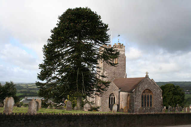
Alder Grove, Devon, also known as Alder Wood or Alder Forest, is a picturesque natural location situated in the county of Devon, England. Spanning over a vast area, this woodland is renowned for its dense growth of alder trees, which give it its name and contribute to its unique ambiance.

The forest is located in a remote and tranquil area, offering a serene and secluded environment for visitors to enjoy. Its natural beauty is enhanced by a diverse range of flora and fauna, making it a haven for nature enthusiasts and wildlife observers. The ecosystem supports a variety of bird species, including woodpeckers, owls, and various songbirds, as well as small mammals such as squirrels and rabbits.

Alder Grove is a popular destination for outdoor activities, attracting hikers, nature walkers, and photographers. Numerous well-marked trails crisscross the forest, allowing visitors to explore its enchanting nooks and crannies. The trails lead to scenic viewpoints, hidden streams, and even a small waterfall, providing opportunities for breathtaking views and tranquil spots for relaxation.

In addition to its natural allure, Alder Grove holds historical significance. Remnants of ancient settlements and archaeological sites can be found within its boundaries, adding an air of mystery and intrigue to the forest. These remnants offer a glimpse into the lives and activities of past civilizations that once inhabited the area.

Overall, Alder Grove, Devon, is a captivating destination that embodies the beauty of nature, offering a serene retreat and a glimpse into the history of the region.

If you have any feedback on the listing, please let us know in the comments section below.

Alder Grove Images

Images are sourced within 2km of 50.939904/-3.2887569 or Grid Reference ST0916. Thanks to Geograph Open Source API. All images are credited.

Field off Lane End
Field off Lane End
Grass field near Burlescombe The M5 visible in the valley below.
Grass field near Burlescombe
The M5 visible in the valley below.
Burlescombe : The M5 Motorway Looking along the M5.
Burlescombe : The M5 Motorway
Looking along the M5.
St Mary's Church Church at Burlescombe.
St Mary's Church
Church at Burlescombe.
The A38, heading north-east
The M5 seen from the A38 overbridge
Chesterfield House, used to be The Poacher's Pocket, on the A38
Lane leading from the A38, heading west
The A38 heading north
Field near Burlescombe
St Mary's Church, Burlescombe
Culmstock: lane near Beacon Cross Riders approach the crossroads from Nicholashayne, on the edge of the Blackdowns near Culmstock Beacon
Culmstock: lane near Beacon Cross
Riders approach the crossroads from Nicholashayne, on the edge of the Blackdowns near Culmstock Beacon
Culmstock: North End View towards Black Down Common and Culm Davy Hill. The pasture has recently had a roller run over it
Culmstock: North End
View towards Black Down Common and Culm Davy Hill. The pasture has recently had a roller run over it
Culmstock: Somerset border The M5 as it passes out of Devon and into Somerset. The Somerset parish beyond the sign is Sampford Arundel. Looking north east
Culmstock: Somerset border
The M5 as it passes out of Devon and into Somerset. The Somerset parish beyond the sign is Sampford Arundel. Looking north east
Culmstock: towards Sampford Point North-north-west from Black Down Common at a point north of Culmstock Beacon. Sampford Point is the dark hill on the right
Culmstock: towards Sampford Point
North-north-west from Black Down Common at a point north of Culmstock Beacon. Sampford Point is the dark hill on the right
Culmstock: Culmstock Beacon This stone hut stands 250m above sea level, close to a triangulation pillar and on the edge of the Blackdown Hills. It partially enclosed a pole-beacon which was a communications signal ready for use when the Spanish Armada was sighted in the English Channel in 1588. Fires on the coast would be lit and then one by one a network of fire beacons set ablaze. This was the signal for all able bodied men to assemble at their local church, await instructions and arm themselves. This is possibly the only beacon hut in the country to survive in its original form. It linked with others at Holcombe Rogus, Upottery and Blackborough. This slit window allowed observers to watch for a light at Upottery beacon. Looking west-north-west
Culmstock: Culmstock Beacon
This stone hut stands 250m above sea level, close to a triangulation pillar and on the edge of the Blackdown Hills. It partially enclosed a pole-beacon which was a communications signal ready for use when the Spanish Armada was sighted in the English Channel in 1588. Fires on the coast would be lit and then one by one a network of fire beacons set ablaze. This was the signal for all able bodied men to assemble at their local church, await instructions and arm themselves. This is possibly the only beacon hut in the country to survive in its original form. It linked with others at Holcombe Rogus, Upottery and Blackborough. This slit window allowed observers to watch for a light at Upottery beacon. Looking west-north-west
Welcome to Somerset
Welcome to Somerset
Peacehay Farm A succession of old and not-so-old farm buildings meet the lane as it drops to cross a little side valley of the Westford Stream.
Peacehay Farm
A succession of old and not-so-old farm buildings meet the lane as it drops to cross a little side valley of the Westford Stream.
Show me another place!

Alder Grove is located at Grid Ref: ST0916 (Lat: 50.939904, Lng: -3.2887569)

Administrative County: Devon

District: Mid Devon

Police Authority: Devon and Cornwall

What 3 Words

///lectured.plump.relax. Near Uffculme, Devon

Nearby Locations

Alder Grove

Related Wikis

Culmstock

Culmstock is a village and civil parish in Mid Devon, England, centred 10 miles from Tiverton and 6 NE of Cullompton. It is laid out on both sides of the...

Wellington Bank, Somerset

Wellington Bank is a steep railway embankment and associated climb located on the Bristol to Exeter line, that climbs from just northeast of Wellington...

Burlescombe

Burlescombe (, bur-LES-kəm) is a village and civil parish in the Mid Devon district of Devon, England. The parish is surrounded, clockwise from the north...

Black Down and Sampford Commons

Black Down and Sampford Commons (grid reference ST118161) is a 155.2-hectare (384-acre) biological Site of Special Scientific Interest in Devon and Somerset...

Sampford Arundel

Sampford Arundel is a village and civil parish in Somerset, England. It is situated near Wellington and 10 miles (16.1 km) south west of Taunton. The village...

Culmstock Halt railway station

Culmstock Halt railway station served the village of Culmstock, Devon, England, from 1876 to 1963 on the Culm Valley Light Railway. == History == The station...

Canonsleigh Abbey

Canonsleigh Abbey was an Augustinian priory in the parish of Burlescombe, Devon. == History == It was founded in about 1170 by Walter de Claville, lord...

Culm Davy

Culm Davy is a historic manor and present-day hamlet within the parish of Hemyock in Devon. == History == The estate of Cumbe is listed in the Domesday...

Nearby Amenities

Located within 500m of 50.939904,-3.2887569
Phone
Emergency: phone
Operator: National Highways
Operator Type: government
Operator Wikidata: Q5760006
Lat/Long: 50.9402972/-3.2935792
Phone
Emergency: phone
Operator: National Highways
Operator Type: government
Operator Wikidata: Q5760006
Lat/Long: 50.94058/-3.2938055
Power: pole
Lat/Long: 50.9357281/-3.2881925
Power: pole
Lat/Long: 50.9367406/-3.289209
Power: pole
Lat/Long: 50.9375553/-3.2900566
Power: pole
Lat/Long: 50.9383615/-3.2909203
Power: pole
Lat/Long: 50.9389463/-3.291961
Material: wood
Power: pole
Lat/Long: 50.9400517/-3.2938868
Material: wood
Power: pole
Lat/Long: 50.9405283/-3.294737
Power: pole
Source: bing
Lat/Long: 50.9382111/-3.2829219
Power: pole
Source: bing
Lat/Long: 50.938397/-3.2841235
Power: pole
Source: bing
Lat/Long: 50.9385947/-3.2853386
Power: pole
Source: bing
Lat/Long: 50.9387824/-3.2865348
Power: pole
Source: bing
Lat/Long: 50.9389632/-3.2877553
Power: pole
Source: bing
Lat/Long: 50.9396156/-3.293412
Power: pole
Source: bing
Transformer: distribution
Lat/Long: 50.9390697/-3.294273
Power: pole
Source: bing
Lat/Long: 50.9400872/-3.2927924
Power: pole
Source: bing
Lat/Long: 50.9399317/-3.2903677
Power: pole
Source: bing
Lat/Long: 50.9394348/-3.2889783
Power: pole
Source: bing
Lat/Long: 50.9403458/-3.291108
Power: pole
Source: bing
Lat/Long: 50.9421981/-3.2944983
Power: pole
Source: bing
Lat/Long: 50.941152/-3.2926396
Power: pole
Source: bing
Lat/Long: 50.9407531/-3.2918751
Power: pole
Source: bing
Lat/Long: 50.9416928/-3.2936588
Power: pole
Source: bing
Lat/Long: 50.9426071/-3.2936803
Power: pole
Source: bing
Lat/Long: 50.9432054/-3.2925752
Power: pole
Source: bing
Lat/Long: 50.9433034/-3.2912877
Power: pole
Source: bing
Lat/Long: 50.9434133/-3.2899788
Power: pole
Source: bing
Lat/Long: 50.9440065/-3.2889542
The data included in this document is from www.openstreetmap.org. The data is made available under ODbL.

Have you been to Alder Grove?

Leave your review of Alder Grove below (or comments, questions and feedback).