Bottom Wood

Wood, Forest in Cumberland Allerdale

England

Bottom Wood
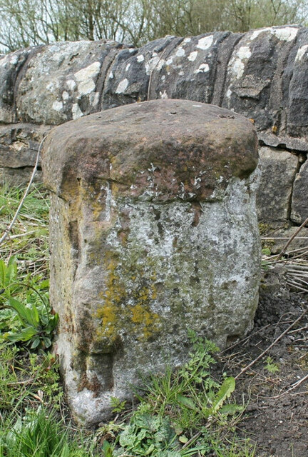
Old Milestone, Chapel Brow, West of Bridgefoot The milestone is located on the south side of the wall opposite Chapel Brow Manor, on the north side of the road. Parish of Little Clifton (Allerdale District). Stone post (plates lost), Whitehaven stone plate design, erected by the Whitehaven Turnpike Trust in the 19th century

Inscription once read:-
TO / WHITEHAVEN / 9 MILES : : TO / COCKERMOUTH / 5 MILES

Milestone Society National ID: CU_CMWH05
Old Milestone, Chapel Brow, West of Bridgefoot Credit: Terry Moore

Bottom Wood, Cumberland is a picturesque forest located in the county of Cumberland, England. Covering an area of approximately 100 hectares, this woodland is renowned for its natural beauty and rich biodiversity. It is situated near the village of Bottom, which is surrounded by rolling hills and stunning landscapes.

Bottom Wood is predominantly composed of deciduous trees, with oak, ash, and beech being the most common species found within the forest. These towering trees create a dense canopy that provides shade and shelter for a variety of wildlife. The forest floor is adorned with a colorful array of wildflowers, ferns, and mosses, creating a vibrant and diverse ecosystem.

The woodland is crisscrossed by a network of well-maintained footpaths, allowing visitors to explore its enchanting surroundings. These paths lead to hidden clearings, babbling brooks, and tranquil ponds, providing opportunities for peaceful walks and nature observation. The forest is also home to a diverse range of bird species, including woodpeckers, owls, and various songbirds, making it a paradise for birdwatchers.

Bottom Wood is managed by a local conservation organization, which ensures the preservation of its natural habitats and protects its resident wildlife. The management team actively engages in sustainable practices such as tree planting and controlled burning to maintain the health and vitality of the forest.

Overall, Bottom Wood, Cumberland is a cherished natural treasure, offering visitors a chance to immerse themselves in the beauty of nature, explore its diverse flora and fauna, and experience a sense of tranquility away from the bustle of modern life.

If you have any feedback on the listing, please let us know in the comments section below.

Bottom Wood Images

Images are sourced within 2km of 54.664588/-3.4730237 or Grid Reference NY0530. Thanks to Geograph Open Source API. All images are credited.

Old Milestone, Chapel Brow, West of Bridgefoot The milestone is located on the south side of the wall opposite Chapel Brow Manor, on the north side of the road. Parish of Little Clifton (Allerdale District). Stone post (plates lost), Whitehaven stone plate design, erected by the Whitehaven Turnpike Trust in the 19th century

Inscription once read:-
TO / WHITEHAVEN / 9 MILES : : TO / COCKERMOUTH / 5 MILES

Milestone Society National ID: CU_CMWH05
Old Milestone, Chapel Brow, West of Bridgefoot
The milestone is located on the south side of the wall opposite Chapel Brow Manor, on the north side of the road. Parish of Little Clifton (Allerdale District). Stone post (plates lost), Whitehaven stone plate design, erected by the Whitehaven Turnpike Trust in the 19th century Inscription once read:- TO / WHITEHAVEN / 9 MILES : : TO / COCKERMOUTH / 5 MILES Milestone Society National ID: CU_CMWH05
Old Milestone northeast of Bridgefoot, Greysouthen parish Carlisle red stone and curved iron plate (plate lost) by the UC road, in parish of Greysouthen (Allerdale District), Bridgefoot, 100m Northeast of Greysouthen turn, in hedge.

Carved inscription reads:-
4
Plate inscription once read:-
(Workington 4)
(Cockermouth 4)

Grade II listed.
List Entry Number: 1144508 <span class="nowrap"><a title="https://historicengland.org.uk/listing/the-list/list-entry/1144508" rel="nofollow ugc noopener" href="https://historicengland.org.uk/listing/the-list/list-entry/1144508">Link</a><img style="margin-left:2px;" alt="External link" title="External link - shift click to open in new window" src="https://s1.geograph.org.uk/img/external.png" width="10" height="10"/></span>

Milestone Society National ID: CU_CMWO04
Old Milestone northeast of Bridgefoot, Greysouthen parish
Carlisle red stone and curved iron plate (plate lost) by the UC road, in parish of Greysouthen (Allerdale District), Bridgefoot, 100m Northeast of Greysouthen turn, in hedge. Carved inscription reads:- 4 Plate inscription once read:- (Workington 4) (Cockermouth 4) Grade II listed. List Entry Number: 1144508 LinkExternal link Milestone Society National ID: CU_CMWO04
A66 Bridgefoot Roundabout Junction with the A595
A66 Bridgefoot Roundabout
Junction with the A595
Play park on William Street With a memorial to all the miners who worked in local coal mines.
Play park on William Street
With a memorial to all the miners who worked in local coal mines.
Old Milestone northeast of Bridgefoot, Greysouthen parish Carlisle red stone and curved iron plate (plate lost) by the UC road, in parish of Greysouthen (Allerdale District), Bridgefoot, 100m Northeast of Greysouthen turn, in hedge.

Carved inscription reads:-
4
Plate inscription once read:-
(Workington 4)
(Cockermouth 4)

Grade II listed.
List Entry Number: 1144508 <span class="nowrap"><a title="https://historicengland.org.uk/listing/the-list/list-entry/1144508" rel="nofollow ugc noopener" href="https://historicengland.org.uk/listing/the-list/list-entry/1144508">Link</a><img style="margin-left:2px;" alt="External link" title="External link - shift click to open in new window" src="https://s1.geograph.org.uk/img/external.png" width="10" height="10"/></span>

Surveyed

Milestone Society National ID: CU_CMWO04
Old Milestone northeast of Bridgefoot, Greysouthen parish
Carlisle red stone and curved iron plate (plate lost) by the UC road, in parish of Greysouthen (Allerdale District), Bridgefoot, 100m Northeast of Greysouthen turn, in hedge. Carved inscription reads:- 4 Plate inscription once read:- (Workington 4) (Cockermouth 4) Grade II listed. List Entry Number: 1144508 LinkExternal link Surveyed Milestone Society National ID: CU_CMWO04
A66 near Great Broughton
Grassland east of Bridgefoot A field of grass being grazed by Herdwick sheep to the east of Bridgefoot.
Grassland east of Bridgefoot
A field of grass being grazed by Herdwick sheep to the east of Bridgefoot.
Road junction east of Bridgefoot A junction between minor roads to the east of Bridgefoot. The road to Greysouthen leaves the road between Bridgefoot and Broughton Cross.
Road junction east of Bridgefoot
A junction between minor roads to the east of Bridgefoot. The road to Greysouthen leaves the road between Bridgefoot and Broughton Cross.
Entering Bridgefoot Looking west along the road which enters Bridgefoot from the east. A road sign warns that there may be squirrels on the road.
Entering Bridgefoot
Looking west along the road which enters Bridgefoot from the east. A road sign warns that there may be squirrels on the road.
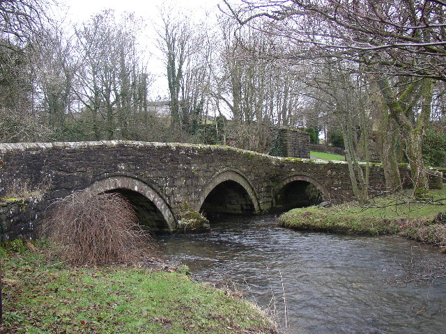
Crossing Bridgefoot Bridge Looking across Bridgefoot Bridge in Bridgefoot. A sign beside the road warns of ducks (or more likely general waterfowl) for 200 yards ahead.
Crossing Bridgefoot Bridge
Looking across Bridgefoot Bridge in Bridgefoot. A sign beside the road warns of ducks (or more likely general waterfowl) for 200 yards ahead.
The River Marron, Bridgefoot Looking downstream along the River Marron from Bridgefoot Bridge.
The River Marron, Bridgefoot
Looking downstream along the River Marron from Bridgefoot Bridge.
The main road through Bridgefoot Looking west along the main road through Bridgefoot. A bus shelter for passengers waiting for buses to Workington is on the left side of the road.
The main road through Bridgefoot
Looking west along the main road through Bridgefoot. A bus shelter for passengers waiting for buses to Workington is on the left side of the road.
Approaching Great Clifton Approaching the village of Great Clifton along the footpath from Little Clifton.
Approaching Great Clifton
Approaching the village of Great Clifton along the footpath from Little Clifton.
The Old Ginn House, Great Clifton The Old Gin House is a pub and hotel located in the centre of Great Clifton.
The Old Ginn House, Great Clifton
The Old Gin House is a pub and hotel located in the centre of Great Clifton.
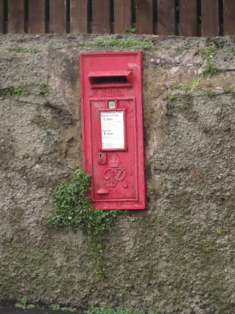
Post box, Great Clifton A post box located in a garden wall in the centre of Great Clifton.
Post box, Great Clifton
A post box located in a garden wall in the centre of Great Clifton.
The Gavels, Great Clifton A residential street of terraced houses in Great Clifton.
The Gavels, Great Clifton
A residential street of terraced houses in Great Clifton.
The Market Cross Free House, Great Clifton The Market Cross, a small pub in the middle of Great Clifton.
The Market Cross Free House, Great Clifton
The Market Cross, a small pub in the middle of Great Clifton.
Playground, Great Clifton An assortment of play equipment in an enclosed grassed area on the edge of Great Clifton.
Playground, Great Clifton
An assortment of play equipment in an enclosed grassed area on the edge of Great Clifton.
Show me another place!

Bottom Wood is located at Grid Ref: NY0530 (Lat: 54.664588, Lng: -3.4730237)

Administrative County: Cumbria

District: Allerdale

Police Authority: Cumbria

What 3 Words

///somewhere.mountain.target. Near Flimby, Cumbria

Nearby Locations

Bottom Wood

Related Wikis

RNAD Broughton Moor

RNAD Broughton Moor is a decommissioned Royal Naval Armaments Depot located between Great Broughton and Broughton Moor in the County of Cumbria, England...

River Marron

The River Marron is a river of Cumbria, England. Rising near the village of Asby, Copeland at the confluence of Colliergate Beck and Scallow Beck, the...

Marron Junction railway station

Marron Junction railway station was a later addition to the Cockermouth and Workington Railway. It opened on 2 April 1866 with a single, eastbound, platform...

Buckhill Colliery Halt railway station

Buckhill Colliery Halt railway station was an unadvertised halt for workers at Buckhill Colliery north east of Camerton, near Cockermouth in Cumberland...

Nearby Amenities

Located within 500m of 54.664588,-3.4730237
Power: pole
Lat/Long: 54.6624416/-3.4736448
Power: pole
Lat/Long: 54.6622061/-3.4741967
Power: pole
Lat/Long: 54.6615008/-3.4757179
Power: pole
Lat/Long: 54.6614446/-3.4769374
Power: pole
Lat/Long: 54.6613753/-3.4782706
The data included in this document is from www.openstreetmap.org. The data is made available under ODbL.

Have you been to Bottom Wood?

Leave your review of Bottom Wood below (or comments, questions and feedback).