Crow Wood

Wood, Forest in Cumberland Copeland

England

Crow Wood

A596 at Lillyhall
A596 at Lillyhall Credit: Colin Pyle

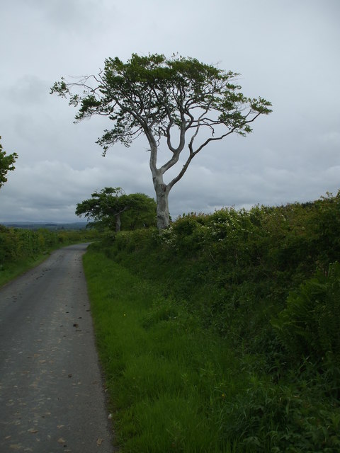
Crow Wood is a picturesque forest located in the county of Cumberland, England. It covers an area of approximately 500 acres and is renowned for its stunning natural beauty and rich biodiversity. The wood is predominantly comprised of ancient oak and beech trees, creating a dense canopy that provides shade and shelter to a diverse array of wildlife.

The wood is intersected by a network of well-maintained trails, allowing visitors to explore its many hidden treasures. The trails wind through the forest, offering breathtaking views of the towering trees, vibrant wildflowers, and enchanting wildlife. The tranquil atmosphere of Crow Wood provides a perfect setting for nature enthusiasts, walkers, and photographers alike.

The forest is home to a wide range of fauna, including deer, foxes, badgers, and various bird species. Birdwatchers will be delighted by the opportunity to spot rare and migratory birds, such as woodpeckers and tawny owls. The wood is also known for its diverse flora, with carpets of bluebells and primroses adorning the forest floor during springtime.

Crow Wood offers various amenities to enhance visitors' experience. There are picnic areas and benches strategically placed throughout the forest, providing a peaceful spot for relaxation and enjoyment of the surroundings. Additionally, the wood has a visitor center where educational programs and guided walks are organized to educate visitors about the forest's ecology and conservation efforts.

Overall, Crow Wood is a haven of natural beauty and tranquility, offering a unique opportunity to immerse oneself in the wonders of nature.

If you have any feedback on the listing, please let us know in the comments section below.

Crow Wood Images

Images are sourced within 2km of 54.598984/-3.5069079 or Grid Reference NY0223. Thanks to Geograph Open Source API. All images are credited.
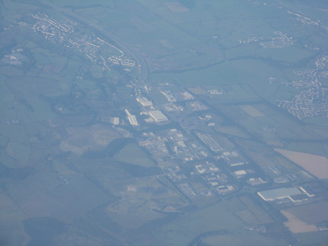
A596 at Lillyhall
A596 at Lillyhall
Leaving Lakes College bound for Whitehaven SHH 389X leaves Lakes College on a shuttle service to Whitehaven on the final day of Leyland National 51.
Leaving Lakes College bound for Whitehaven
SHH 389X leaves Lakes College on a shuttle service to Whitehaven on the final day of Leyland National 51.
Distington (Joint) station, with train 1951 View SW, towards Cleator Moor (Cleator & Workington Junction Railway, with excursion train returning to Carlisle from Egremont headed by LMS 4F 0-6-0 No. 44461 (built 5/28, withdrawn 9/64). The line to the left is to Rowrah and Kelton Fell.
Distington (Joint) station, with train 1951
View SW, towards Cleator Moor (Cleator & Workington Junction Railway, with excursion train returning to Carlisle from Egremont headed by LMS 4F 0-6-0 No. 44461 (built 5/28, withdrawn 9/64). The line to the left is to Rowrah and Kelton Fell.
Distington (Joint) station, 1951 View SW, towards Cleator Moor (ahead), left to Rowrah and Kelton Fell also WC&E line to Parton and Ullock. The station was closed finally 13/4/31 (goods C&WJ 1/7/63). Passenger services were withdrawn during the 1920s; goods gradually during the 20s and 30s, and to Cleator Moor until 9/61, then only as a diversionary route. (See also <a href="https://www.geograph.org.uk/photo/5325623">NY0124 : Distington (Joint) station, with train 1951</a>).
Distington (Joint) station, 1951
View SW, towards Cleator Moor (ahead), left to Rowrah and Kelton Fell also WC&E line to Parton and Ullock. The station was closed finally 13/4/31 (goods C&WJ 1/7/63). Passenger services were withdrawn during the 1920s; goods gradually during the 20s and 30s, and to Cleator Moor until 9/61, then only as a diversionary route. (See also NY0124 : Distington (Joint) station, with train 1951).
Old Milestone by the A595, north of Distington Metal plates attached to stone post by the A595, in parish of WINSCALES (ALLERDALE District), East of secondary school, Distington T-junction, in front of Toyota garage, on grass verge, on North West side of road, East of new roundabout. Whitehaven plate stone, erected by the Whitehaven turnpike trust in the 19th century. 

Inscription reads:-
: TO WORKINGTON / 3 / TO COCKERMOUTH / 9 MILES : : TO / WHITEHAVEN / 5 MILES :

Grade II Listed. List Entry Number: 1312130
<span class="nowrap"><a title="https://historicengland.org.uk/listing/the-list/list-entry/1312130" rel="nofollow ugc noopener" href="https://historicengland.org.uk/listing/the-list/list-entry/1312130">Link</a><img style="margin-left:2px;" alt="External link" title="External link - shift click to open in new window" src="https://s1.geograph.org.uk/img/external.png" width="10" height="10"/></span>

Milestone Society National ID: CU_WHWO05.
Old Milestone by the A595, north of Distington
Metal plates attached to stone post by the A595, in parish of WINSCALES (ALLERDALE District), East of secondary school, Distington T-junction, in front of Toyota garage, on grass verge, on North West side of road, East of new roundabout. Whitehaven plate stone, erected by the Whitehaven turnpike trust in the 19th century. Inscription reads:- : TO WORKINGTON / 3 / TO COCKERMOUTH / 9 MILES : : TO / WHITEHAVEN / 5 MILES : Grade II Listed. List Entry Number: 1312130 LinkExternal link Milestone Society National ID: CU_WHWO05.
Nos. 1 and 2 Staff Houses, Harrington Road
Lakes College and BEC Construction Skills Centre
Field north of minor road close to Friar Bank Wood The ploughed field is close to various small settlements, east of Pica for example; it's also north of the area of relatively low-level moorland at High Park. The notice on the gate declares that the land is private.
Field north of minor road close to Friar Bank Wood
The ploughed field is close to various small settlements, east of Pica for example; it's also north of the area of relatively low-level moorland at High Park. The notice on the gate declares that the land is private.
Car park, Distington Hall Crematorium
Distington from the air The buildings at Lillyhall Industrial Estate are prominent,as is the A595 road curving away towards the coast. Workington and the coast are hidden by the bank of fog.
Distington from the air
The buildings at Lillyhall Industrial Estate are prominent,as is the A595 road curving away towards the coast. Workington and the coast are hidden by the bank of fog.
Lillyhall Industrial Estate from the air Looking southwest from an Edinburgh-Manchester flight, with three wind farms in view [at Capel How, Moresby Moss, and Cunning Point], and the Cumbrian coast and Solway Firth.
Lillyhall Industrial Estate from the air
Looking southwest from an Edinburgh-Manchester flight, with three wind farms in view [at Capel How, Moresby Moss, and Cunning Point], and the Cumbrian coast and Solway Firth.
Lillyhall Industrial Estate, Cumbria An aerial view looking southwest from a flight from Edinburgh to Manchester. The road heading out to the top left is the A595 to Whitehaven.
Lillyhall Industrial Estate, Cumbria
An aerial view looking southwest from a flight from Edinburgh to Manchester. The road heading out to the top left is the A595 to Whitehaven.
The lane to Pica
The lane to Pica
Pica village Pica is an old mining community situated 182m asl.
Pica village
Pica is an old mining community situated 182m asl.
Railway Bridge Abutments Stone abutments are all that remain of the bridge that carried the Cleator & Workington Junction Railway.
Railway Bridge Abutments
Stone abutments are all that remain of the bridge that carried the Cleator & Workington Junction Railway.
Country lane near Gilgarren Farmland belonging to Kelmore Hill Farm on the right of the hedge.
Country lane near Gilgarren
Farmland belonging to Kelmore Hill Farm on the right of the hedge.
Road into Gilgarren
Road into Gilgarren
Sparse looking trees alongside a country lane
Show me another place!

Crow Wood is located at Grid Ref: NY0223 (Lat: 54.598984, Lng: -3.5069079)

Administrative County: Cumbria

District: Copeland

Police Authority: Cumbria

What 3 Words

///warping.sock.bookings. Near Distington, Cumbria

Nearby Locations

Crow Wood Dyon Wood

Related Wikis

Distington railway station

Distington railway station was opened jointly by the Cleator and Workington Junction Railway (C&WJR) and the LNWR and Furness Joint Railway (The Joint...

Lakes College

Lakes College is a further education institute located at Lillyhall, Cumberland, England, between the towns of Workington and Whitehaven. The college offers...

Energy Coast UTC

Energy Coast is a University Technical College (UTC) on the outskirts of Workington, Cumbria that opened in September 2014 for students of ages 14–19....

Distington

Distington () is a large village and civil parish in Cumbria, England, 3 miles (4.8 km) south of Workington and 4 miles (6.4 km) north of Whitehaven. Historically...

Nearby Amenities

Located within 500m of 54.598984,-3.5069079
Barrier: stile
Lat/Long: 54.5949686/-3.505509
Crow Wood
Natural: wood
Lat/Long: 54.5988469/-3.5067789
Power: pole
Lat/Long: 54.5991874/-3.5131634
Power: pole
Lat/Long: 54.6030009/-3.5081054
Power: pole
Lat/Long: 54.6015201/-3.5099811
Power: pole
Lat/Long: 54.6007842/-3.5109695
Power: pole
Lat/Long: 54.5999936/-3.5120311
Power: pole
Lat/Long: 54.598393/-3.5142816
Power: pole
Lat/Long: 54.5974389/-3.5131128
Power: pole
Lat/Long: 54.5966926/-3.5121871
Power: pole
Lat/Long: 54.5957819/-3.5110811
Power: pole
Lat/Long: 54.6004571/-3.5098171
Power: pole
Lat/Long: 54.6001074/-3.5086098
Power: pole
Lat/Long: 54.5997612/-3.5073842
Power: pole
Lat/Long: 54.5993951/-3.5060838
Power: pole
Lat/Long: 54.5987579/-3.5052512
Power: pole
Lat/Long: 54.5981559/-3.5044876
Power: pole
Lat/Long: 54.5975375/-3.5036976
Power: pole
Lat/Long: 54.5968651/-3.5028083
Power: pole
Lat/Long: 54.5961938/-3.5019595
The data included in this document is from www.openstreetmap.org. The data is made available under ODbL.

Have you been to Crow Wood?

Leave your review of Crow Wood below (or comments, questions and feedback).