Moorhouse Plantation

Wood, Forest in Somerset Somerset West and Taunton

England

Moorhouse Plantation

Henstown Farm house
Henstown Farm house Credit: Rob Purvis

Moorhouse Plantation, located in Somerset, England, is a picturesque woodland area known for its dense forest cover and serene natural beauty. Spanning over several acres of land, the plantation is a haven for nature enthusiasts and outdoor adventurers alike.

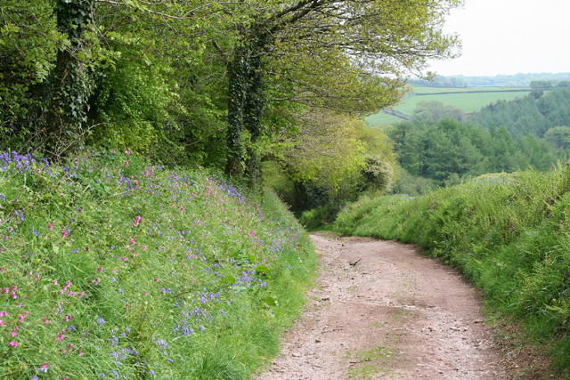
The woodland, consisting primarily of oak and beech trees, creates a dense canopy that provides shelter to a diverse range of flora and fauna. The plantation is also home to various species of wildflowers, creating a vibrant and colorful landscape throughout the seasons.

The area is crisscrossed by numerous walking trails, allowing visitors to explore the plantation at their own pace. These well-maintained paths offer stunning views of the woodland and make for a peaceful and enjoyable hike. Additionally, the plantation is a popular spot for birdwatching, with a wide variety of species, including woodpeckers and owls, calling it home.

Moorhouse Plantation is also known for its historical significance. It was once a site of timber production, with the wood from the plantation being used for shipbuilding and construction in the local area. The remnants of old sawmills and logging equipment can still be found scattered throughout the woodland, serving as a reminder of its past.

Overall, Moorhouse Plantation in Somerset is a natural gem, offering a tranquil escape from the hustle and bustle of everyday life. With its lush forest, scenic trails, and rich history, it is a must-visit destination for nature lovers and history enthusiasts alike.

If you have any feedback on the listing, please let us know in the comments section below.

Moorhouse Plantation Images

Images are sourced within 2km of 51.055124/-3.4209125 or Grid Reference ST0029. Thanks to Geograph Open Source API. All images are credited.

Henstown Farm house
Henstown Farm house
Entering Upton, heading south
B3190 near Newhouses Heading towards the southern edge of the square; the central tree is just in <a href="https://www.geograph.org.uk/gridref/ST0029">ST0029</a>.
B3190 near Newhouses
Heading towards the southern edge of the square; the central tree is just in ST0029.
Road closed at Sperry Cross Uh-oh - the road across Sperry Moor to Huish Champflower is closed for a week, or perhaps 5 days, or maybe only 3 depending on your source of information. It's to renew a faulty aerial cable - although Somerset's roadworks map indicates surface dressing patching. Anyway, it will involve quite a long diversion for drivers. I'm certainly forced to revise my plans for the morning. 

The crossroads is also shown at <a title="https://www.geograph.org.uk/search.php?i=106371855" href="https://www.geograph.org.uk/search.php?i=106371855">Link</a> .
Road closed at Sperry Cross
Uh-oh - the road across Sperry Moor to Huish Champflower is closed for a week, or perhaps 5 days, or maybe only 3 depending on your source of information. It's to renew a faulty aerial cable - although Somerset's roadworks map indicates surface dressing patching. Anyway, it will involve quite a long diversion for drivers. I'm certainly forced to revise my plans for the morning. The crossroads is also shown at Link .
Signpost, Sperry Cross Visible in <a href="https://www.geograph.org.uk/photo/2143955">ST0130 : Sperry Cross</a> but deserving of closer attention.
Signpost, Sperry Cross
Visible in ST0130 : Sperry Cross but deserving of closer attention.
B3190 at Newhouses Looking the other way along the road shown in <a href="https://www.geograph.org.uk/photo/6334728">ST0030 : B3190 near Newhouses</a>.
B3190 at Newhouses
Looking the other way along the road shown in ST0030 : B3190 near Newhouses.
Gateway by the B3190 The impressive entrance gates at the rear entrance to Bittescombe Manor.
Gateway by the B3190
The impressive entrance gates at the rear entrance to Bittescombe Manor.
Sperry Cross The signpost is shown in more detail at <a href="https://www.geograph.org.uk/photo/6337260">ST0130 : Signpost, Sperry Cross</a>.
Sperry Cross
The signpost is shown in more detail at ST0130 : Signpost, Sperry Cross.
Road west from Sperry Cross The crowded signpost shown in <a href="https://www.geograph.org.uk/photo/6337260">ST0130 : Signpost, Sperry Cross</a> is just across to the right.
Road west from Sperry Cross
The crowded signpost shown in ST0130 : Signpost, Sperry Cross is just across to the right.
Track to Withy Cottage Leaving the B3190, and carrying bridleway DU 9/28.
Track to Withy Cottage
Leaving the B3190, and carrying bridleway DU 9/28.
B3190 near Withy Cottage Looking right from <a href="https://www.geograph.org.uk/photo/6526034">ST0131 : Track to Withy Cottage</a>.
B3190 near Withy Cottage
Looking right from ST0131 : Track to Withy Cottage.
Direction Sign – Signpost at Sperry Cross Located on the northwest side of Sperry Cross crossroads on the B3190 in Upton parish. 7 arms and pyramid finial. See also <a title="https://www.geograph.org.uk/photo/6337260" href="https://www.geograph.org.uk/photo/6337260">Link</a>.

Milestone Society National ID: SO_ST0130
Direction Sign – Signpost at Sperry Cross
Located on the northwest side of Sperry Cross crossroads on the B3190 in Upton parish. 7 arms and pyramid finial. See also Link. Milestone Society National ID: SO_ST0130
Upton: Lowtrow Cross Inn An inn locally recognised for its food, it stands by the crossroads it’s named after. Looking north
Upton: Lowtrow Cross Inn
An inn locally recognised for its food, it stands by the crossroads it’s named after. Looking north
Upton: Leeford Farm There was no doubt a ford here in earlier times and it is now in culvert. Two bridleways converge on the newly tarmaced lane by the farm. Looking south
Upton: Leeford Farm
There was no doubt a ford here in earlier times and it is now in culvert. Two bridleways converge on the newly tarmaced lane by the farm. Looking south
Upton: by Lotley Farm Looking south near the entrance to Lotley Farm
Upton: by Lotley Farm
Looking south near the entrance to Lotley Farm
Skilgate: the road from Lowtrow Cross Looking south-south-west
Skilgate: the road from Lowtrow Cross
Looking south-south-west
Skilgate: bridleway from Haddon End Looking east-north-east. The track leads to Dulverton Lane and Heydon Hill
Skilgate: bridleway from Haddon End
Looking east-north-east. The track leads to Dulverton Lane and Heydon Hill
Skilgate: near Haddon End Looking south west over farmland
Skilgate: near Haddon End
Looking south west over farmland
Show me another place!

Moorhouse Plantation is located at Grid Ref: ST0029 (Lat: 51.055124, Lng: -3.4209125)

Administrative County: Somerset

District: Somerset West and Taunton

Police Authority: Avon and Somerset

What 3 Words

///crucially.obey.bead. Near Wiveliscombe, Somerset

Related Wikis

Upton, Somerset

Upton is a village and civil parish north of Skilgate in Somerset, England. It is situated on a hill above the eastern end of Wimbleball Lake. == History... ==

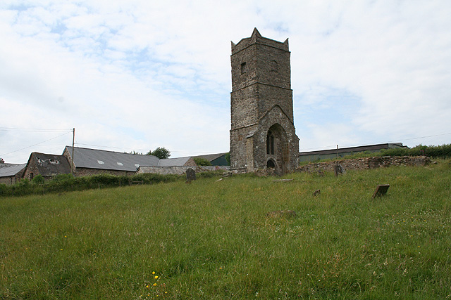
Old Church of St James, Upton

The Old St James's Church is a former church in the village of Upton, Somerset, England, of which only the tower remains, overlooking Wimbleball Lake....

Skilgate

Skilgate is a village and civil parish 5 miles (8 km) east of Dulverton and 8 miles (13 km) west of Wiveliscombe in the Somerset West and Taunton district...

Church of St John, Skilgate

The Anglican Church of St John in Skilgate, Somerset, England was built in the 14th century. It is a Grade II* listed building. == History == The church...
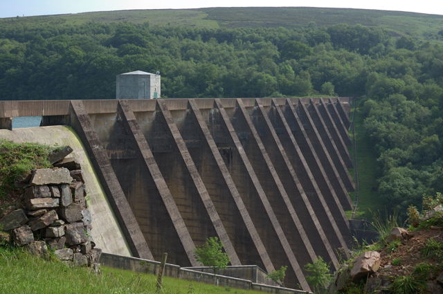
Wimbleball Lake

Wimbleball Lake on Exmoor in Somerset, England, is a water supply reservoir constructed in the 1970s and completed in 1979. The 161 feet (49 m) high dam...

Huish Champflower

Huish Champflower is a village and civil parish in Somerset, England, three miles north-west of Wiveliscombe and ten miles north of Wellington. It has...

Clatworthy Reservoir

Clatworthy Reservoir is situated near Clatworthy in the Brendon Hills on the edge of the Exmoor National Park in west Somerset, England. It is run by Wessex...

Church of St Mary Magdalene, Withiel Florey

The Anglican Church of St Mary Magdalene in Withiel Florey, Somerset, England was built in the 12th century. It is a Grade II* listed building. == History... ==

Nearby Amenities

Located within 500m of 51.055124,-3.4209125
Lowtrow Cross
Junction: yes
Lat/Long: 51.0534036/-3.4182713
The data included in this document is from www.openstreetmap.org. The data is made available under ODbL.

Have you been to Moorhouse Plantation?

Leave your review of Moorhouse Plantation below (or comments, questions and feedback).