Clarbeston Road

Settlement in Pembrokeshire

Wales

Clarbeston Road

Ordnance Survey Cut Mark This OS cut mark can be found on the south parapet of Cartlett Brook Bridge. It marks a point 59.082m above mean sea level.
Ordnance Survey Cut Mark Credit: Adrian Dust

Clarbeston Road is a village located in the county of Pembrokeshire, Wales. Situated approximately 8 miles northeast of Haverfordwest, it is a rural settlement with a population of around 1,000 people. The village is conveniently positioned near the A40 road, which connects it to the nearby towns and cities.

Despite its small size, Clarbeston Road has a range of amenities for its residents. These include a convenience store, a post office, a primary school, and a village hall. Additionally, there is a railway station in the village, providing access to the national rail network.

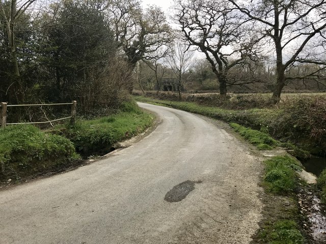
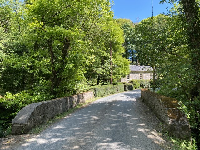
The surrounding countryside is characterized by rolling hills, farmland, and picturesque landscapes. This makes Clarbeston Road an attractive location for those seeking a peaceful and rural setting. The village is also within easy reach of the stunning Pembrokeshire Coast National Park, offering residents and visitors the opportunity to explore beautiful beaches, rugged cliffs, and diverse wildlife.

Clarbeston Road is well-connected to neighboring towns and cities, with regular bus services and good road links. Haverfordwest, the county town of Pembrokeshire, is just a short drive away and offers a wider range of amenities, including shopping centers, restaurants, and leisure facilities.

Overall, Clarbeston Road provides a peaceful and rural lifestyle for its residents, with easy access to essential amenities and stunning natural beauty.

If you have any feedback on the listing, please let us know in the comments section below.

Clarbeston Road Images

Images are sourced within 2km of 51.849762/-4.882629 or Grid Reference SN0120. Thanks to Geograph Open Source API. All images are credited.
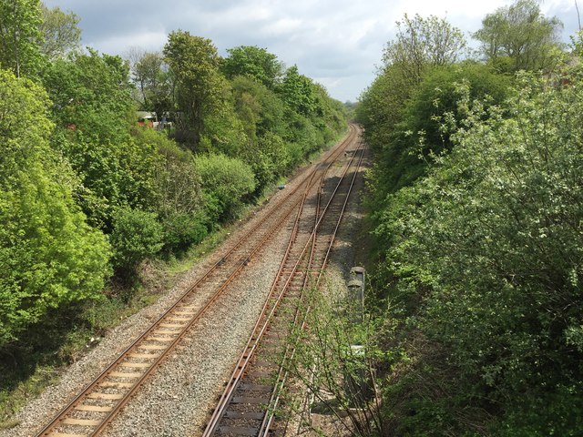
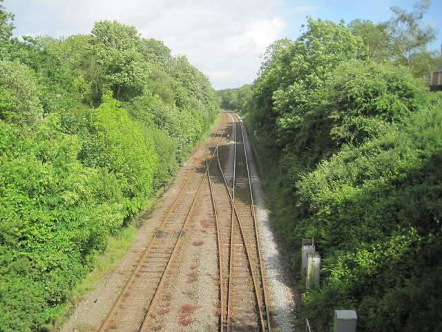
Ordnance Survey Cut Mark This OS cut mark can be found on the south parapet of Cartlett Brook Bridge. It marks a point 59.082m above mean sea level.
Ordnance Survey Cut Mark
This OS cut mark can be found on the south parapet of Cartlett Brook Bridge. It marks a point 59.082m above mean sea level.
Pathway to Clarbeston Road Station Pathway to Clarbeston Road railway station.
Pathway to Clarbeston Road Station
Pathway to Clarbeston Road railway station.
Railway at Clarbeston Road Clarbeston Road to Whitland railway line.
Railway at Clarbeston Road
Clarbeston Road to Whitland railway line.
Clarbeston Road station An Arriva train bound for Milford Haven has just pulled in and two passengers wait for the doors to open. Victorian OS maps show the station to be east of the road bridge [from where this shot was taken], but now it is on the west side. I stopped in the hope that the station would be an old GWR style building, but was obviously disappointed. I would guess that before the GWR built the line through here, the village of Clarbeston Road would not have existed, though a map of the 1880's shows a few dwellings and two pubs.
Clarbeston Road station
An Arriva train bound for Milford Haven has just pulled in and two passengers wait for the doors to open. Victorian OS maps show the station to be east of the road bridge [from where this shot was taken], but now it is on the west side. I stopped in the hope that the station would be an old GWR style building, but was obviously disappointed. I would guess that before the GWR built the line through here, the village of Clarbeston Road would not have existed, though a map of the 1880's shows a few dwellings and two pubs.
The Cross Inn, Clarbeston Road The pub is so called because it was on a crossroads - the Maenclochog to Haverfordwest road and the Woodstock to Wiston road. The layout was changed when the railway was built. The inn was mentioned as early as 1770.
The Cross Inn, Clarbeston Road
The pub is so called because it was on a crossroads - the Maenclochog to Haverfordwest road and the Woodstock to Wiston road. The layout was changed when the railway was built. The inn was mentioned as early as 1770.
Clarbeston Road The village is named after the railway station. Given that it's in the parish of Wiston, and it's on the road to Wiston, it's odd that it wasn't called Wiston Road.
Clarbeston Road
The village is named after the railway station. Given that it's in the parish of Wiston, and it's on the road to Wiston, it's odd that it wasn't called Wiston Road.
Ordnance Survey Cut Mark This OS cut mark can be found on the gatepost east side of the road. It marks a point 88.599m above mean sea level.
Ordnance Survey Cut Mark
This OS cut mark can be found on the gatepost east side of the road. It marks a point 88.599m above mean sea level.
Clarbeston Road railway station, Pembrokeshire Opened in 1854 by the South Wales Railway on its line from Carmarthen to Neyland, the station was originally on the east (far) side of the road bridge - see <a href="https://www.geograph.org.uk/photo/6819716">SN0120 : Clarbeston Road 1st railway station (site), Pembrokeshire</a>. 
Line extensions to Fishguard and Milford Haven were later added and the station is believed to have been moved to this site in 1914 by the Great Western Railway. This allowed for a bay platform to be included on the north side of the line (extreme left of image), now removed.
View south east towards Clunderwen and Carmarthen.
Clarbeston Road railway station, Pembrokeshire
Opened in 1854 by the South Wales Railway on its line from Carmarthen to Neyland, the station was originally on the east (far) side of the road bridge - see SN0120 : Clarbeston Road 1st railway station (site), Pembrokeshire. Line extensions to Fishguard and Milford Haven were later added and the station is believed to have been moved to this site in 1914 by the Great Western Railway. This allowed for a bay platform to be included on the north side of the line (extreme left of image), now removed. View south east towards Clunderwen and Carmarthen.
Cross Inn, Clarbeston Road This pub serves the small community of Clarbeston Road, centred around the railway station and some two miles west of Clarbeston itself. The name of the pub indicates it was once at a crossroads, but that was eliminated when the railway was built.
Cross Inn, Clarbeston Road
This pub serves the small community of Clarbeston Road, centred around the railway station and some two miles west of Clarbeston itself. The name of the pub indicates it was once at a crossroads, but that was eliminated when the railway was built.
Cant Moor Ford This ford on Cartlett Brook is found at Cant Moor.
Cant Moor Ford
This ford on Cartlett Brook is found at Cant Moor.
Penty Park lodge Bridge over Cartlett Brook at Penty Park.
Penty Park lodge
Bridge over Cartlett Brook at Penty Park.
Clarbeston Road 1st railway station (site), Pembrokeshire Opened in 1854 by the South Wales Railway on its line from Carmarthen to Neyland, this station lost its wooden booking office in a fire in 1907. In 1914 it is believed to have closed and replaced by a new station immediately behind the camera position (see <a href="https://www.geograph.org.uk/photo/5421673">SN0120 : Clarbeston Road railway station, Pembrokeshire</a>), although some OS maps were showing it at this location until 1963.
View south east towards Clunderwen and Carmarthen.
Clarbeston Road 1st railway station (site), Pembrokeshire
Opened in 1854 by the South Wales Railway on its line from Carmarthen to Neyland, this station lost its wooden booking office in a fire in 1907. In 1914 it is believed to have closed and replaced by a new station immediately behind the camera position (see SN0120 : Clarbeston Road railway station, Pembrokeshire), although some OS maps were showing it at this location until 1963. View south east towards Clunderwen and Carmarthen.
Clarbeston Road Station Road Bridge as seen from platform at Clarbeston Road Station.

Taken with the Lomo LC-A on Kodak Tri-x 400
Clarbeston Road Station
Road Bridge as seen from platform at Clarbeston Road Station. Taken with the Lomo LC-A on Kodak Tri-x 400
Minor road junction near Clarbeston Road View of a minor road junction by Beacon Hill Wood.The road to the right leads to Plenty-Park Mill.
Minor road junction near Clarbeston Road
View of a minor road junction by Beacon Hill Wood.The road to the right leads to Plenty-Park Mill.
Rural crossroads Rural crossroads and finger post between Walton East and Clarbeston Road.
Rural crossroads
Rural crossroads and finger post between Walton East and Clarbeston Road.
Tree-lined country road Tree-lined country road heading for Walton East from Clarbeston Road.
Tree-lined country road
Tree-lined country road heading for Walton East from Clarbeston Road.
Road Junction near Clarbeston Road The road junction can be seen beyond the house on the road to Wiston from Clarbeston Road. Turn left into Lamborough Lane.
Road Junction near Clarbeston Road
The road junction can be seen beyond the house on the road to Wiston from Clarbeston Road. Turn left into Lamborough Lane.
Country Road through Millpark Wood View of a country road approaching a bridge through Millpark Wood.
Country Road through Millpark Wood
View of a country road approaching a bridge through Millpark Wood.
Show me another place!

Clarbeston Road is located at Grid Ref: SN0120 (Lat: 51.849762, Lng: -4.882629)

Unitary Authority: Pembrokeshire

Police Authority: Dyfed Powys

What 3 Words

///hurry.arena.televise. Near Wiston, Pembrokeshire

Related Wikis

Clarbeston Road railway station

Clarbeston Road railway station serves villages such as Clarbeston Road, Clarbeston, Wiston, Walton East and Crundale in Pembrokeshire, Wales. The station...

Walton East

Walton East (Welsh: Waltwn) is a small rural village and parish established around a church at least as early as Norman times. It is 2 miles (3.2 km) southwest...
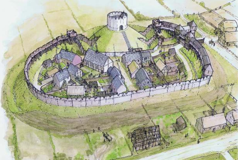
Wiston Castle

Wiston Castle (Welsh: Castell Cas-wis) is a motte and bailey castle in the Pembrokeshire village of Wiston in south west Wales and is one of the best examples...

Wiston, Pembrokeshire

Wiston (Welsh: Cas-Wis) is a village, parish and community in Pembrokeshire, Wales, in the United Kingdom. It was once a marcher borough. George Owen,...

Nearby Amenities

Located within 500m of 51.849762,-4.882629
Clarbeston Road
Naptan AtcoCode: 9100CLARBRD
Network: National Rail
Network Website: https://www.nationalrail.co.uk/stations/clr/
Network Wikidata: Q26334
Operator: Trafnidiaeth Cymru
Operator Cy: Trafnidiaeth Cymru
Operator En: Transport for Wales
Operator Website: https://tfw.wales/places/stations/clarbeston-road
Operator Wikidata: Q104878180
Railway: station
Ref Crs: CLR
Request Stop: yes
Wikidata: Q2137827
Wikipedia: en:Clarbeston Road railway station
Lat/Long: 51.8517201/-4.8821672
Pub
Cross Keys
Addr Postcode: SA63 4UL
Fhrs Id: 856424
Name En: The Cross Inn
Phone: +44 1437 731506
Source Addr: FHRS Open Data
Lat/Long: 51.8526438/-4.8791454
Railway: switch
Lat/Long: 51.8529347/-4.8866202
Railway: switch
Lat/Long: 51.851394/-4.8809642
Railway: switch
Lat/Long: 51.8512794/-4.8803785
Clarbeston Road
Place: village
Source: OS OpenData StreetView
Lat/Long: 51.851878/-4.8814438
Give Way
Direction: backward
Lat/Long: 51.8482742/-4.8798611
Give Way
Direction: backward
Lat/Long: 51.8513781/-4.8813734
Give Way
Direction: forward
Lat/Long: 51.8522833/-4.8793898
Direction: 85
Generator Method: photovoltaic
Generator Output Electricity: yes
Generator Solar Modules: 7
Generator Source: solar
Generator Type: solar_photovoltaic_panel
Location: roof
Power: generator
Lat/Long: 51.8483561/-4.8807413
Direction: 95
Generator Method: photovoltaic
Generator Output Electricity: yes
Generator Solar Modules: 14
Generator Source: solar
Generator Type: solar_photovoltaic_panel
Location: roof
Power: generator
Lat/Long: 51.8500255/-4.8784936
Direction: 175
Generator Method: photovoltaic
Generator Output Electricity: yes
Generator Solar Modules: 7
Generator Source: solar
Generator Type: solar_photovoltaic_panel
Location: roof
Power: generator
Lat/Long: 51.8483155/-4.8808935
Direction: 175
Generator Method: photovoltaic
Generator Output Electricity: yes
Generator Solar Modules: 7
Generator Source: solar
Generator Type: solar_photovoltaic_panel
Location: roof
Power: generator
Lat/Long: 51.8485028/-4.8808104
Man Made: utility_pole
Lat/Long: 51.8473228/-4.8832421
The data included in this document is from www.openstreetmap.org. The data is made available under ODbL.

Have you been to Clarbeston Road?

Leave your review of Clarbeston Road below (or comments, questions and feedback).