Goyle Down Plantation

Wood, Forest in Devon Mid Devon

England

Goyle Down Plantation

Titchen's Bradley Looking from Titchen's Bradley towards Plainsfield and beyond towards East Devon.
Titchen's Bradley Credit: Tim

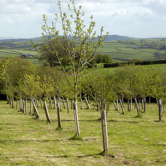
Goyle Down Plantation is a picturesque woodland located in Devon, England. Nestled in the heart of the countryside, it covers an expansive area of lush greenery and is known for its diverse range of plant and animal species. The plantation is situated in close proximity to the small village of Wood, adding to its charm and accessibility.

The woodland is predominantly composed of native tree species, including oak, beech, and birch. These trees create a dense canopy, providing a haven for various wildlife species. Within the plantation, visitors can expect to encounter a plethora of birdlife, such as woodpeckers, owls, and songbirds. Additionally, the woodland is home to several mammals, including deer, foxes, and badgers.

Goyle Down Plantation offers a range of recreational activities for nature enthusiasts. It boasts an extensive network of walking trails, allowing visitors to explore the beauty of the woodland at their own pace. These paths wind through the plantation, offering glimpses of the surrounding countryside and providing opportunities for peaceful solitude.

The plantation is managed by local conservation organizations, ensuring the preservation and protection of the woodland's natural habitat. Efforts are made to maintain the biodiversity of the area, allowing for the continued flourishing of its flora and fauna.

Overall, Goyle Down Plantation is a haven of tranquility and natural beauty, offering visitors the chance to immerse themselves in the wonders of Devon's woodlands. Whether it's a leisurely stroll or a birdwatching adventure, this enchanting woodland provides a captivating experience for all who venture within its boundaries.

If you have any feedback on the listing, please let us know in the comments section below.

Goyle Down Plantation Images

Images are sourced within 2km of 50.920043/-3.5461902 or Grid Reference SS9114. Thanks to Geograph Open Source API. All images are credited.

Titchen's Bradley Looking from Titchen's Bradley towards Plainsfield and beyond towards East Devon.
Titchen's Bradley
Looking from Titchen's Bradley towards Plainsfield and beyond towards East Devon.
Building work at Bradley View Farm
Ivy-covered trig point near West Bradley In needs of some TLC.
Ivy-covered trig point near West Bradley
In needs of some TLC.
Stately tree on the road to Templeton
Titchen's Lane Tiverton Footpath 3 follows this lane to farm buildings and Bradlegh House, continuing through to the Dart valley at Morchard Mill. At this oak tree the lane becomes enclosed between lines of overhanging trees.
Titchen's Lane
Tiverton Footpath 3 follows this lane to farm buildings and Bradlegh House, continuing through to the Dart valley at Morchard Mill. At this oak tree the lane becomes enclosed between lines of overhanging trees.
Titchen's Lane A reverse view of <a href="https://www.geograph.org.uk/photo/2428680">SS8913 : Titchen's Lane</a>, with the same oak in the centre.
Titchen's Lane
A reverse view of SS8913 : Titchen's Lane, with the same oak in the centre.
Titchen's Lane Further down the lane shown in <a href="https://www.geograph.org.uk/photo/2428680">SS8913 : Titchen's Lane</a>, with the trees almost forming a tunnel.
Titchen's Lane
Further down the lane shown in SS8913 : Titchen's Lane, with the trees almost forming a tunnel.
Field by Titchen's Lane In the centre, a crow is flying over what was a line of trees along a truncated field boundary; its northern (right-hand) end is in <a href="https://www.geograph.org.uk/gridref/SS8914">SS8914</a>.
Field by Titchen's Lane
In the centre, a crow is flying over what was a line of trees along a truncated field boundary; its northern (right-hand) end is in SS8914.
Titchen's Lane Looking up the lane shown in <a href="https://www.geograph.org.uk/photo/2428930">SS8913 : Titchen's Lane</a> and carrying Tiverton Footpath 3. <a href="https://www.geograph.org.uk/photo/2429114">SS8913 : Field by Titchen's Lane</a> was taken from the chain on the left.
Titchen's Lane
Looking up the lane shown in SS8913 : Titchen's Lane and carrying Tiverton Footpath 3. SS8913 : Field by Titchen's Lane was taken from the chain on the left.
Field by Tombstone Lane The field boundary doesn't appear on the current 1:25000 map, though it does on large scales. On the extreme left is Higher Way Farm, just in square; the nearer fields to its right likewise.
Field by Tombstone Lane
The field boundary doesn't appear on the current 1:25000 map, though it does on large scales. On the extreme left is Higher Way Farm, just in square; the nearer fields to its right likewise.
Field by Tombstone Lane Looking past the other side of the field boundary shown in <a href="https://www.geograph.org.uk/photo/2429334">SS8914 : Field by Tombstone Lane</a>. The further fields are out of square, mainly <a href="https://www.geograph.org.uk/gridref/SS9015">SS9015</a>.
Field by Tombstone Lane
Looking past the other side of the field boundary shown in SS8914 : Field by Tombstone Lane. The further fields are out of square, mainly SS9015.
Field by Tombstone Lane The track is leading around into the next field westwards. The scattered trees along the field boundary opposite appear in <a href="https://www.geograph.org.uk/photo/2429114">SS8913 : Field by Titchen's Lane</a>; Tombstone Lane runs along the ridge top.
Field by Tombstone Lane
The track is leading around into the next field westwards. The scattered trees along the field boundary opposite appear in SS8913 : Field by Titchen's Lane; Tombstone Lane runs along the ridge top.
Manure heap, West Bradley In the corner of a field beside Tombstone Lane. On the far side of the field the land falls away to a trinutary of the Dart.
Manure heap, West Bradley
In the corner of a field beside Tombstone Lane. On the far side of the field the land falls away to a trinutary of the Dart.
Footpath and road to Lower Way Farm
A neglected trig pillar This trig point is in the hedge near Lower Way Farm
A neglected trig pillar
This trig point is in the hedge near Lower Way Farm
Mid Devon : Titchen's Lane Titchen's Lane heading through the Mid Devon countryside.
Mid Devon : Titchen's Lane
Titchen's Lane heading through the Mid Devon countryside.
Mid Devon : Titchen's Lane Titchen's Lane heading through the Mid Devon countryside.
Mid Devon : Titchen's Lane
Titchen's Lane heading through the Mid Devon countryside.
Mid Devon : Grassy Field A grassy field with trees beside Titchen's Lane in Mid Devon.
Mid Devon : Grassy Field
A grassy field with trees beside Titchen's Lane in Mid Devon.
Show me another place!

Goyle Down Plantation is located at Grid Ref: SS9114 (Lat: 50.920043, Lng: -3.5461902)

Administrative County: Devon

District: Mid Devon

Police Authority: Devon and Cornwall

What 3 Words

///figure.prospers.relaxing. Near Tiverton, Devon

Nearby Locations

Goyle Down Plantation

Related Wikis

Calverleigh

Calverleigh (anciently Calwoodleigh) is a village and former civil parish and manor, now in the parish of Loxbeare, in the Mid Devon district, in the county...

Loxbeare

Loxbeare is a village and civil parish in Devon, England. The church is from the twelfth century and the tower is probably Norman. It is dedicated to St...

Washfield

Washfield is a village, parish and former manor in Mid Devon, Devon, England, situated about 2 miles north-west of Tiverton. The parish church is dedicated...

Templeton, Devon

Templeton is a hamlet, parish and former manor in Devon, England, situated 4 miles west of Tiverton. The parish church is dedicated to St Margaret. �...

Nearby Amenities

Located within 500m of 50.920043,-3.5461902
Frogwell
Place: hamlet
Lat/Long: 50.9158735/-3.5467611
Leigh Bridge
Place: locality
Lat/Long: 50.9216629/-3.5458042
Generator Method: photovoltaic
Generator Output Electricity: yes
Generator Source: solar
Generator Type: solar_photovoltaic_panel
Location: roof
Power: generator
Lat/Long: 50.9198122/-3.5521545
Power: pole
Source: bing
Transformer: distribution
Lat/Long: 50.9198297/-3.5532993
Power: pole
Source: bing
Lat/Long: 50.9183366/-3.5519099
Power: pole
Source: bing
Lat/Long: 50.9184787/-3.5502349
Power: pole
Source: bing
Lat/Long: 50.9185751/-3.5489193
Power: pole
Source: bing
Lat/Long: 50.9168241/-3.5454418
Power: pole
Source: bing
Lat/Long: 50.9164859/-3.5462049
Power: pole
Source: bing
Transformer: distribution
Lat/Long: 50.9161781/-3.5469948
Power: pole
Source: bing
Lat/Long: 50.9174235/-3.5412669
Power: pole
Source: bing
Lat/Long: 50.9174168/-3.5432088
Power: pole
Source: bing
Lat/Long: 50.9176527/-3.54192
Power: pole
Source: bing
Lat/Long: 50.9167336/-3.5442965
Power: pole
Source: bing
Lat/Long: 50.9158238/-3.5450676
Power: pole
Source: bing
Lat/Long: 50.9171953/-3.5444775
Power: pole
Source: bing
Lat/Long: 50.918039/-3.5448584
Power: pole
Source: bing
Lat/Long: 50.918685/-3.5451615
Power: pole
Source: bing
Lat/Long: 50.9182048/-3.5449389
Power: pole
Source: bing
Lat/Long: 50.9187137/-3.547208
Power: pole
Source: bing
Lat/Long: 50.918942/-3.54628
Power: pole
Source: bing
Lat/Long: 50.9191618/-3.545419
Poles: bipole
Power: pole
Source: bing
Lat/Long: 50.919265/-3.5453466
Power: pole
Source: bing
Lat/Long: 50.919992/-3.5446921
Power: pole
Source: bing
Lat/Long: 50.9207546/-3.5440081
Power: pole
Source: bing
Lat/Long: 50.9212771/-3.5434663
Power: pole
Source: bing
Lat/Long: 50.9219906/-3.5428816
Power: pole
Source: bing
Lat/Long: 50.9221225/-3.5420314
Power: pole
Source: bing
Lat/Long: 50.9222611/-3.5411623
The data included in this document is from www.openstreetmap.org. The data is made available under ODbL.

Have you been to Goyle Down Plantation?

Leave your review of Goyle Down Plantation below (or comments, questions and feedback).