Ashwellhill Wood

Wood, Forest in Devon Teignbridge

England

Ashwellhill Wood

Old Milestone by UC road (was A38), New Exeter Road, by Oakfields The Milestone is located in a hedge by the road.  Parish of Chudleigh (Teignbridge District). Carved stone post, Exeter tombstone design, erected by the Exeter turnpike trust in the 19th Century, missing in 2005. An earlier photograph can be found here: <span class="nowrap"><a title="http://www.flickr.com/photos/bridgemarkertim/5123846159" rel="nofollow ugc noopener" href="http://www.flickr.com/photos/bridgemarkertim/5123846159">Link</a><img style="margin-left:2px;" alt="External link" title="External link - shift click to open in new window" src="https://s1.geograph.org.uk/img/external.png" width="10" height="10"/></span> 

Inscription reads:-  
9 / MILES / TO / EXETER  

Milestone Society National ID: DV_EXCH09
Old Milestone by UC road (was A38), New Exeter Road, by Oakfields Credit: Max Piper

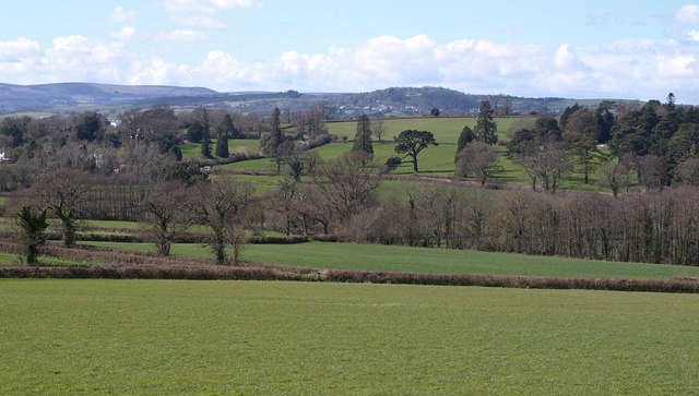
Ashwellhill Wood, located in Devon, is a picturesque woodland that covers an area of approximately 50 acres. It is situated near the village of Ashwell, offering a natural escape for locals and visitors alike. The wood is part of the larger Ashwellhill Forest, contributing to the rich biodiversity of the region.

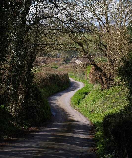
Ashwellhill Wood is characterized by its dense canopy of predominantly deciduous trees, including oak, beech, and ash. These trees provide a stunning display of vibrant colors during the autumn months, attracting nature enthusiasts and photographers. The woodland floor is covered in a lush carpet of ferns, bluebells, and wildflowers, creating a serene and tranquil atmosphere.

The wood is crisscrossed with a network of well-maintained footpaths and trails, allowing visitors to explore its beauty at their own pace. These paths wind through the wood, leading to hidden clearings, ancient trees, and small streams. The area is popular among hikers, dog walkers, and families seeking a peaceful retreat in nature.

Wildlife thrives within Ashwellhill Wood, with various species calling it their home. Birdwatchers can spot a range of avian species, including woodpeckers, nuthatches, and treecreepers. Squirrels scurry through the treetops, while elusive deer can occasionally be spotted grazing in the clearings.

Ashwellhill Wood is a cherished natural gem in Devon, providing a haven for both flora and fauna. Its beauty and tranquility make it an ideal destination for those seeking a peaceful escape from the hustle and bustle of everyday life.

If you have any feedback on the listing, please let us know in the comments section below.

Ashwellhill Wood Images

Images are sourced within 2km of 50.59642/-3.5777217 or Grid Reference SX8878. Thanks to Geograph Open Source API. All images are credited.

Old Milestone by UC road (was A38), New Exeter Road, by Oakfields The Milestone is located in a hedge by the road.  Parish of Chudleigh (Teignbridge District). Carved stone post, Exeter tombstone design, erected by the Exeter turnpike trust in the 19th Century, missing in 2005. An earlier photograph can be found here: <span class="nowrap"><a title="http://www.flickr.com/photos/bridgemarkertim/5123846159" rel="nofollow ugc noopener" href="http://www.flickr.com/photos/bridgemarkertim/5123846159">Link</a><img style="margin-left:2px;" alt="External link" title="External link - shift click to open in new window" src="https://s1.geograph.org.uk/img/external.png" width="10" height="10"/></span> 

Inscription reads:-  
9 / MILES / TO / EXETER  

Milestone Society National ID: DV_EXCH09
Old Milestone by UC road (was A38), New Exeter Road, by Oakfields
The Milestone is located in a hedge by the road.  Parish of Chudleigh (Teignbridge District). Carved stone post, Exeter tombstone design, erected by the Exeter turnpike trust in the 19th Century, missing in 2005. An earlier photograph can be found here: LinkExternal link  Inscription reads:- 9 / MILES / TO / EXETER Milestone Society National ID: DV_EXCH09
Amberley Some map scales have "Amberly" but I think this is the correct spelling. Old maps show a cottage called Porcombe here. On the left is the winding lane shown in <a href="https://www.geograph.org.uk/photo/749220">SX8880 : Lane at Amberley</a>.
Amberley
Some map scales have "Amberly" but I think this is the correct spelling. Old maps show a cottage called Porcombe here. On the left is the winding lane shown in SX8880 : Lane at Amberley.
Bridleway near Waddon Chudleigh Bridleway 3 approaches Ridge Lane.
Bridleway near Waddon
Chudleigh Bridleway 3 approaches Ridge Lane.
Gate near Waddon Chudleigh Bridleway 3.
Gate near Waddon
Chudleigh Bridleway 3.
Lower Upcott Another view of <a href="https://www.geograph.org.uk/photo/166446">SX8880 : Lower Upcott</a> from the lane near Lower Amberley.
Lower Upcott
Another view of SX8880 : Lower Upcott from the lane near Lower Amberley.
Lower Upcott The farm lies next to a disused quarry.
Lower Upcott
The farm lies next to a disused quarry.
Lane past Kerswell House Attractive limestone walls line this curious lane, which has just performed two hairpins as it drops past Lower Upcott into the Kate Brook valley. Kerswell House, partly obscured by trees on the right, occupies grounds on a hill that have old-looking features such as the walls, but the house appears modern.
Lane past Kerswell House
Attractive limestone walls line this curious lane, which has just performed two hairpins as it drops past Lower Upcott into the Kate Brook valley. Kerswell House, partly obscured by trees on the right, occupies grounds on a hill that have old-looking features such as the walls, but the house appears modern.
Lane at Amberley The lane from Amberley Farm towards Kerswell Cross follows a sinuous course as it drops to the Kate Brook valley.
Lane at Amberley
The lane from Amberley Farm towards Kerswell Cross follows a sinuous course as it drops to the Kate Brook valley.
Bridge, Stancott This bridge seems to be new, as it is hard to detect on any map or satellite image. It crosses the lane climbing past Kerswell House between the two hairpins.
Bridge, Stancott
This bridge seems to be new, as it is hard to detect on any map or satellite image. It crosses the lane climbing past Kerswell House between the two hairpins.
Kate Brook valley Taken from the same place as <a href="https://www.geograph.org.uk/photo/756103">SX8880 : Kate Brook valley</a>, looking further to the left. The park-like grounds at Filleigh on the right across the brook are in <a href="https://www.geograph.org.uk/gridref/SX8780">SX8780</a>. Hennock is in the distance.
Kate Brook valley
Taken from the same place as SX8880 : Kate Brook valley, looking further to the left. The park-like grounds at Filleigh on the right across the brook are in SX8780. Hennock is in the distance.
Towards Chudleigh from near Kerswell House Taken from the same place as <a href="https://www.geograph.org.uk/photo/756103">SX8880 : Kate Brook valley</a>. The farm across the fields is Hams Barton in SX8780; above it are houses on the B3344 north of Chudleigh, which is to the left. Dartmoor forms the skyline.
Towards Chudleigh from near Kerswell House
Taken from the same place as SX8880 : Kate Brook valley. The farm across the fields is Hams Barton in SX8780; above it are houses on the B3344 north of Chudleigh, which is to the left. Dartmoor forms the skyline.
Hams Barton
Hams Barton
Minor road junction, near Waddon
Lane to Waddon
Lane to Waddon
Lane, to Kerswell Cross
Track at Lower Upcott
The road near Kerswell House Kerswell House is hidden by the trees.
The road near Kerswell House
Kerswell House is hidden by the trees.
Ugbrooke House - Pond Pond by the entrance to the stately home of Baron Clifford of Chudleigh.
<span class="nowrap"><a title="www.ugbrooke.co.uk" rel="nofollow ugc noopener" href="http://www.ugbrooke.co.uk">Link</a><img style="margin-left:2px;" alt="External link" title="External link - shift click to open in new window" src="https://s1.geograph.org.uk/img/external.png" width="10" height="10"/></span>
Ugbrooke House - Pond
Pond by the entrance to the stately home of Baron Clifford of Chudleigh. LinkExternal link
Show me another place!

Ashwellhill Wood is located at Grid Ref: SX8878 (Lat: 50.59642, Lng: -3.5777217)

Administrative County: Devon

District: Teignbridge

Police Authority: Devon and Cornwall

What 3 Words

///truckload.laces.skills. Near Chudleigh, Devon

Related Wikis

Ugbrooke

Ugbrooke House is a stately home in the parish of Chudleigh, Devon, England, situated in a valley between Exeter and Newton Abbot. The home of the Clifford...

Ideford Common

Ideford Common is a Site of Special Scientific Interest consisting of an area of lowland heath in Devon, England. The site is a habitat for nightjars and...

Ideford

Ideford (or Ideford Parish) is a village in the Teignbridge district of Devon, England. It is 5 miles (8 km) north of Newton Abbot. To the west is the...

Chudleigh Town Hall

Chudleigh Town Hall is a municipal building in Market Way, Chudleigh, Devon, England. The town hall, which is the meeting place of Chudleigh Town Council...

Nearby Amenities

Located within 500m of 50.59642,-3.5777217
Lower Dunscombe Farm
Building: yes
Lat/Long: 50.599239/-3.5761406
The data included in this document is from www.openstreetmap.org. The data is made available under ODbL.

Have you been to Ashwellhill Wood?

Leave your review of Ashwellhill Wood below (or comments, questions and feedback).