Barn Wood

Wood, Forest in Devon South Hams

England

Barn Wood

Waddeton Road The lane to Pords Bridge spends a mere 180 metres in the square.
Waddeton Road Credit: Derek Harper

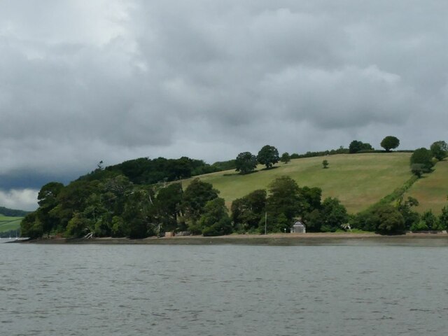
Located in the county of Devon, Barn Wood is a picturesque forest known for its abundant natural beauty and rich biodiversity. Covering an area of approximately 500 acres, this woodland is a popular destination for nature enthusiasts and outdoor lovers.

Barn Wood is characterized by its dense canopy of tall, mature trees, including oak, beech, and ash, which provide a sheltered habitat for numerous wildlife species. The forest floor is adorned with a vibrant carpet of bluebells, wildflowers, and ferns, creating a stunning sight during the spring and summer months.

The woodland is crisscrossed by a network of well-maintained footpaths and trails, allowing visitors to explore its various sections and discover its hidden gems. These trails cater to all levels of fitness and are suitable for walking, jogging, and horse riding. The forest also offers designated picnic areas, making it an ideal spot for a family day out or a peaceful retreat.

Barn Wood is home to a diverse range of wildlife, including deer, badgers, foxes, and various bird species, making it a paradise for bird watchers and animal enthusiasts. The forest is also reputed for its population of rare butterflies, adding to its ecological significance.

Managed by the local forestry commission, Barn Wood is well-preserved and maintained, ensuring the conservation of its natural environment. The forest is open to the public throughout the year, with no entry fees. However, visitors are encouraged to follow the guidelines to protect the flora and fauna and maintain the serenity of this natural haven.

If you have any feedback on the listing, please let us know in the comments section below.

Barn Wood Images

Images are sourced within 2km of 50.395413/-3.5802676 or Grid Reference SX8756. Thanks to Geograph Open Source API. All images are credited.

Waddeton Road The lane to Pords Bridge spends a mere 180 metres in the square.
Waddeton Road
The lane to Pords Bridge spends a mere 180 metres in the square.
Field by Waddeton Road The field to the southeast of <a href="https://www.geograph.org.uk/photo/6911336">SX8556 : Field by Waddeton Road</a>.
Field by Waddeton Road
The field to the southeast of SX8556 : Field by Waddeton Road.
Field by Waddeton Road Looking left from <a href="https://www.geograph.org.uk/photo/6911336">SX8556 : Field by Waddeton Road</a>, with trees along the boundary with the field shown in <a href="https://www.geograph.org.uk/photo/6918139">SX8556 : Field by Waddeton Road</a>.
Field by Waddeton Road
Looking left from SX8556 : Field by Waddeton Road, with trees along the boundary with the field shown in SX8556 : Field by Waddeton Road.
Broadsands : Hookhills Viaduct by Brunel More at <a href="https://www.geograph.org.uk/photo/2475112">SX8957 : Hookhills Viaduct</a>.
Broadsands : Hookhills Viaduct by Brunel
Broadsands : Hookhills Viaduct by Brunel More at <a href="https://www.geograph.org.uk/photo/2475112">SX8957 : Hookhills Viaduct</a>.
Broadsands : Hookhills Viaduct by Brunel
Train at Churston station, 1977 Great Western Railway 4575 Class 2-6-2T number 4588 leaves Churston station with a train heading for Paignton. 100 of this class were built at Swindon between 1927-1929. 4588 is one of 11 which still survive.

The Paignton to Kingswear line was officially closed by British Rail in October 1972, but was sold to the Dart Valley Light Railway Ltd in December 1972 and services were able to continue as the Torbay Steam Railway.

When photographed in 1977, the line through the station was single track. The loop was reinstated in 1979.
Train at Churston station, 1977
Great Western Railway 4575 Class 2-6-2T number 4588 leaves Churston station with a train heading for Paignton. 100 of this class were built at Swindon between 1927-1929. 4588 is one of 11 which still survive. The Paignton to Kingswear line was officially closed by British Rail in October 1972, but was sold to the Dart Valley Light Railway Ltd in December 1972 and services were able to continue as the Torbay Steam Railway. When photographed in 1977, the line through the station was single track. The loop was reinstated in 1979.
4588 at Churston Great Western Railway 4575 Class 2-6-2T number 4588 goes under the road bridge at Churston station with a train heading for Paignton. 100 of this class were built at Swindon between 1927-1929. 4588 is one of 11 which still survive.

The part of the bridge seen here (which carried the A379, Dartmouth Road over the railway) was originally over a double track. There was a smaller arch to the right which went over the single track branch line to Brixham. The whole bridge has been replaced by a modern and much wider concrete version since this photograph was taken in 1977.
4588 at Churston
Great Western Railway 4575 Class 2-6-2T number 4588 goes under the road bridge at Churston station with a train heading for Paignton. 100 of this class were built at Swindon between 1927-1929. 4588 is one of 11 which still survive. The part of the bridge seen here (which carried the A379, Dartmouth Road over the railway) was originally over a double track. There was a smaller arch to the right which went over the single track branch line to Brixham. The whole bridge has been replaced by a modern and much wider concrete version since this photograph was taken in 1977.
Brunel Road, Broadsands Houses along a road not far from Broad Sands beach.
Brunel Road, Broadsands
Houses along a road not far from Broad Sands beach.
Houses on Brunel Road, Broadsands Looking the other way along the road from <a href="https://www.geograph.org.uk/photo/7000254">SX8956 : Brunel Road, Broadsands</a>.
Houses on Brunel Road, Broadsands
Looking the other way along the road from SX8956 : Brunel Road, Broadsands.
Braveheart near Broadsands A further view of locomotive 75014, shown in <a href="https://www.geograph.org.uk/photo/7000744">SX8957 : Braveheart on viaduct, Broadsands</a> crossing the Broadsands Viaduct a little further northeast.
Braveheart near Broadsands
A further view of locomotive 75014, shown in SX8957 : Braveheart on viaduct, Broadsands crossing the Broadsands Viaduct a little further northeast.
Class 03 at Churston Class 03 No. 03371 shunts USATC 2-8-0T No. 2253 at Churston station on the Dartmouth Steam Railway.
Class 03 at Churston
Class 03 No. 03371 shunts USATC 2-8-0T No. 2253 at Churston station on the Dartmouth Steam Railway.
Greenway viaduct and the River Dart
Greenway House Agatha Christie's house, the scene of some of her novels.
Greenway House
Agatha Christie's house, the scene of some of her novels.
Sandridge Point Complete with a small boathouse.
Sandridge Point
Complete with a small boathouse.
Greenway House from the river I'm not sure whether the higher building here is the main house, or an outbuilding.
Greenway House from the river
I'm not sure whether the higher building here is the main house, or an outbuilding.
Dittisham Sailing Club Nestled among trees on the west bank of the river.
Dittisham Sailing Club
Nestled among trees on the west bank of the river.
Jetty at Lower Dittisham On the west bank of the river.
Jetty at Lower Dittisham
On the west bank of the river.
The Quay at Lower Dittisham On the west bank of the river.
The Quay at Lower Dittisham
On the west bank of the river.
Show me another place!

Barn Wood is located at Grid Ref: SX8756 (Lat: 50.395413, Lng: -3.5802676)

Administrative County: Devon

District: South Hams

Police Authority: Devon and Cornwall

What 3 Words

///shopper.hazel.boost. Near Stoke Gabriel, Devon

Related Wikis

Greenway Halt railway station (Devon)

Greenway Halt railway station is a small railway station on the Dartmouth Steam Railway, a heritage railway in Devon, England. It is situated near the...

Galmpton, Torbay

Galmpton is a semi-rural village in Torbay, in the ceremonial county of Devon, England. It is located in the ward of Churston-with-Galmpton and the historic...
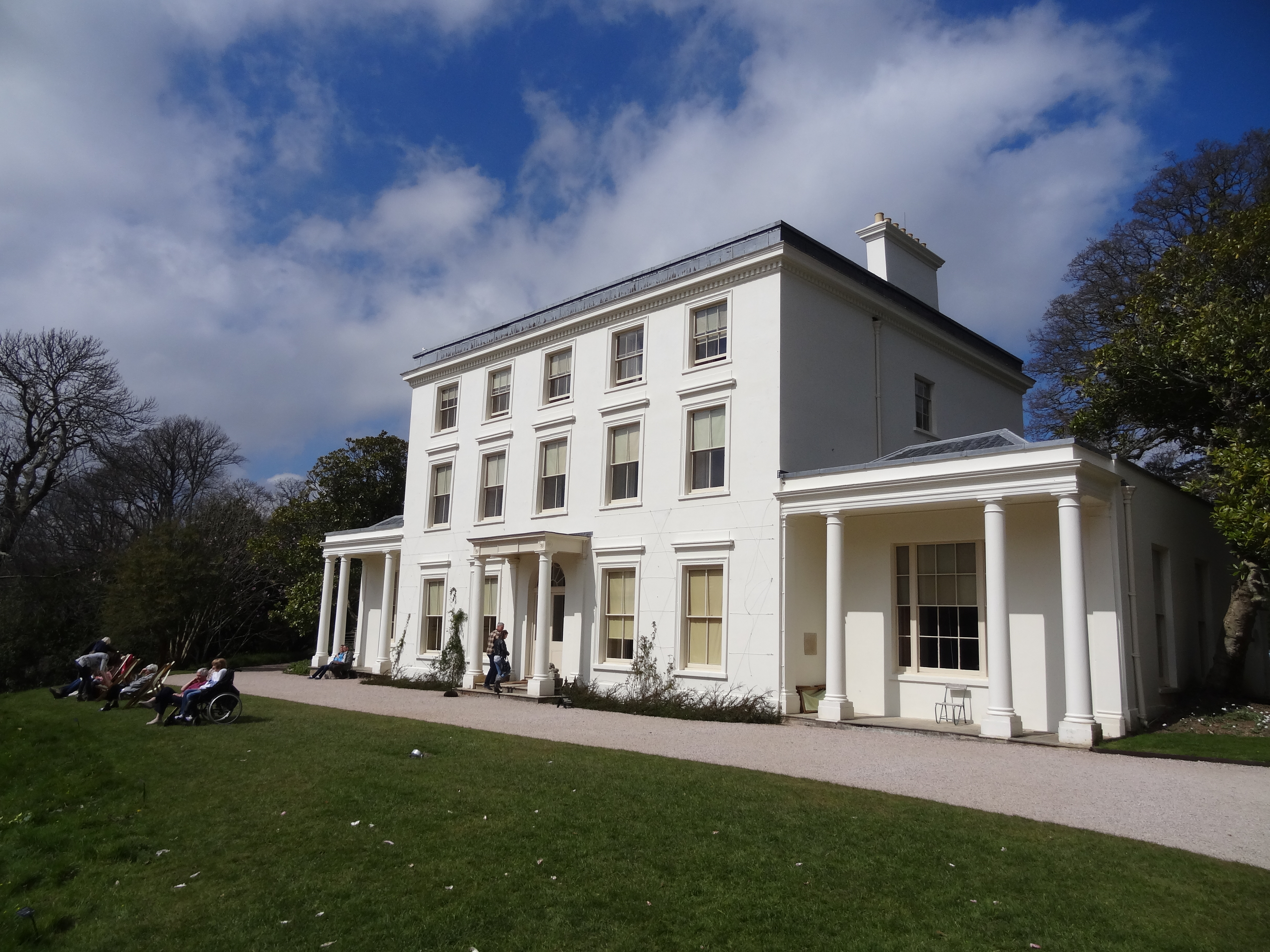
Greenway Estate

Greenway, also known as Greenway House, is an estate on the River Dart near Galmpton in Devon, England. Once the home of the author Agatha Christie, it...

Churston Ferrers Grammar School

Churston Ferrers Grammar School (also known as CFGS) is a selective coeducational Grammar School with Academy status, situated in the village of Galmpton...

Nearby Amenities

Located within 500m of 50.395413,-3.5802676
Source: PGS
Lat/Long: 50.3942051/-3.5869275
Source: PGS
Lat/Long: 50.3934777/-3.5860157
Source: PGS
Lat/Long: 50.393276/-3.5852693
Source: PGS
Lat/Long: 50.3934935/-3.5844902
Source: PGS
Lat/Long: 50.393986/-3.5830284
Source: PGS
Lat/Long: 50.3928286/-3.5819345
Source: PGS
Lat/Long: 50.3926271/-3.5813216
Source: PGS
Lat/Long: 50.3924516/-3.580671
Source: PGS
Lat/Long: 50.3923802/-3.5791817
Source: PGS
Lat/Long: 50.3924112/-3.5790064
Source: PGS
Lat/Long: 50.3924403/-3.5785569
Source: PGS
Lat/Long: 50.393/-3.5757108
Source: PGS
Lat/Long: 50.3926495/-3.5749759
Dartside Quay
Waterway: boatyard
Lat/Long: 50.3933239/-3.5754482
Barrier: stile
Lat/Long: 50.3971825/-3.5755862
Leisure: slipway
Lat/Long: 50.3928473/-3.576174
Galmpton Creek
Tourism: information
Lat/Long: 50.3923595/-3.576328
Defibrillator
Emergency: defibrillator
Survey Date: 2022-04-15
Lat/Long: 50.3934294/-3.575165
Life Ring
Emergency: life_ring
Survey Date: 2022-04-15
Lat/Long: 50.3931449/-3.5755277
The data included in this document is from www.openstreetmap.org. The data is made available under ODbL.

Have you been to Barn Wood?

Leave your review of Barn Wood below (or comments, questions and feedback).