Waddeton

Settlement in Devon South Hams

England

Waddeton

Waddeton Road The lane to Pords Bridge spends a mere 180 metres in the square.
Waddeton Road Credit: Derek Harper

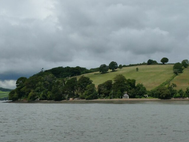
Waddeton is a small village located in the county of Devon, in southwestern England. Situated on the banks of the River Dart, it is part of the South Hams district. The village is surrounded by picturesque countryside, with rolling hills and lush green fields providing a scenic backdrop.

Waddeton is a quiet and peaceful village, with a population of just over 200 residents. It is known for its quaint charm and traditional English character. The village features a cluster of stone houses, many of which date back several centuries, giving it a sense of history and heritage.

The River Dart, which flows through the village, offers recreational opportunities for both residents and visitors alike. Boating, fishing, and swimming are popular activities in the area, with several boat rental and tour companies operating in the vicinity.

Nature lovers will find Waddeton to be a haven, as the village is surrounded by beautiful countryside and is in close proximity to Dartmoor National Park. The park offers stunning landscapes, rugged moorland, and ample opportunities for hiking, cycling, and wildlife spotting.

Despite its small size, Waddeton is conveniently located near the town of Totnes, which is just a short drive away. Totnes provides a range of amenities, including shops, restaurants, and schools, ensuring that residents have easy access to essential services.

Overall, Waddeton is a charming village that offers a peaceful and idyllic lifestyle, making it an attractive place for those seeking a rural retreat in the heart of Devon.

If you have any feedback on the listing, please let us know in the comments section below.

Waddeton Images

Images are sourced within 2km of 50.401108/-3.584368 or Grid Reference SX8756. Thanks to Geograph Open Source API. All images are credited.

Waddeton Road The lane to Pords Bridge spends a mere 180 metres in the square.
Waddeton Road
The lane to Pords Bridge spends a mere 180 metres in the square.
Field by Waddeton Road The field to the southeast of <a href="https://www.geograph.org.uk/photo/6911336">SX8556 : Field by Waddeton Road</a>.
Field by Waddeton Road
The field to the southeast of SX8556 : Field by Waddeton Road.
Field by Waddeton Road Looking left from <a href="https://www.geograph.org.uk/photo/6911336">SX8556 : Field by Waddeton Road</a>, with trees along the boundary with the field shown in <a href="https://www.geograph.org.uk/photo/6918139">SX8556 : Field by Waddeton Road</a>.
Field by Waddeton Road
Looking left from SX8556 : Field by Waddeton Road, with trees along the boundary with the field shown in SX8556 : Field by Waddeton Road.
Broadsands : Hookhills Viaduct by Brunel More at <a href="https://www.geograph.org.uk/photo/2475112">SX8957 : Hookhills Viaduct</a>.
Broadsands : Hookhills Viaduct by Brunel
Broadsands : Hookhills Viaduct by Brunel More at <a href="https://www.geograph.org.uk/photo/2475112">SX8957 : Hookhills Viaduct</a>.
Broadsands : Hookhills Viaduct by Brunel
Train at Churston station, 1977 Great Western Railway 4575 Class 2-6-2T number 4588 leaves Churston station with a train heading for Paignton. 100 of this class were built at Swindon between 1927-1929. 4588 is one of 11 which still survive.

The Paignton to Kingswear line was officially closed by British Rail in October 1972, but was sold to the Dart Valley Light Railway Ltd in December 1972 and services were able to continue as the Torbay Steam Railway.

When photographed in 1977, the line through the station was single track. The loop was reinstated in 1979.
Train at Churston station, 1977
Great Western Railway 4575 Class 2-6-2T number 4588 leaves Churston station with a train heading for Paignton. 100 of this class were built at Swindon between 1927-1929. 4588 is one of 11 which still survive. The Paignton to Kingswear line was officially closed by British Rail in October 1972, but was sold to the Dart Valley Light Railway Ltd in December 1972 and services were able to continue as the Torbay Steam Railway. When photographed in 1977, the line through the station was single track. The loop was reinstated in 1979.
4588 at Churston Great Western Railway 4575 Class 2-6-2T number 4588 goes under the road bridge at Churston station with a train heading for Paignton. 100 of this class were built at Swindon between 1927-1929. 4588 is one of 11 which still survive.

The part of the bridge seen here (which carried the A379, Dartmouth Road over the railway) was originally over a double track. There was a smaller arch to the right which went over the single track branch line to Brixham. The whole bridge has been replaced by a modern and much wider concrete version since this photograph was taken in 1977.
4588 at Churston
Great Western Railway 4575 Class 2-6-2T number 4588 goes under the road bridge at Churston station with a train heading for Paignton. 100 of this class were built at Swindon between 1927-1929. 4588 is one of 11 which still survive. The part of the bridge seen here (which carried the A379, Dartmouth Road over the railway) was originally over a double track. There was a smaller arch to the right which went over the single track branch line to Brixham. The whole bridge has been replaced by a modern and much wider concrete version since this photograph was taken in 1977.
Braveheart on viaduct, Broadsands Part of the stock of the Dartmouth Steam Railway, locomotive 75014 was built in December 1951 in Swindon <span class="nowrap"><a title="https://www.dartmouthrailriver.co.uk/trains" rel="nofollow ugc noopener" href="https://www.dartmouthrailriver.co.uk/trains">Link</a><img style="margin-left:2px;" alt="External link" title="External link - shift click to open in new window" src="https://s1.geograph.org.uk/img/external.png" width="10" height="10"/></span> . Seen from near Churston Point, it is crossing the Broadsands Viaduct, shown in <a href="https://www.geograph.org.uk/photo/6788318">SX8957 : Viaduct above Broad Sands</a>.
Braveheart on viaduct, Broadsands
Part of the stock of the Dartmouth Steam Railway, locomotive 75014 was built in December 1951 in Swindon LinkExternal link . Seen from near Churston Point, it is crossing the Broadsands Viaduct, shown in SX8957 : Viaduct above Broad Sands.
Braveheart near Broadsands A further view of locomotive 75014, shown in <a href="https://www.geograph.org.uk/photo/7000744">SX8957 : Braveheart on viaduct, Broadsands</a> crossing the Broadsands Viaduct a little further northeast.
Braveheart near Broadsands
A further view of locomotive 75014, shown in SX8957 : Braveheart on viaduct, Broadsands crossing the Broadsands Viaduct a little further northeast.
Sandridge Point Complete with a small boathouse.
Sandridge Point
Complete with a small boathouse.
Dittisham Sailing Club Nestled among trees on the west bank of the river.
Dittisham Sailing Club
Nestled among trees on the west bank of the river.
Paddocks outside Galmpton Seen from a train on the Dartmouth Steam Railway.
Paddocks outside Galmpton
Seen from a train on the Dartmouth Steam Railway.
Epic Centre, Torbay Viewed over the car park on a Saturday morning. 
To quote from their website: 'EPIC is a modern purpose-built innovation centre dedicated to electronics and photonics companies. In addition to modern labs and offices, EPIC also has technical capability to support R&D, Design and New Product Development'.
Epic Centre, Torbay
Viewed over the car park on a Saturday morning. To quote from their website: 'EPIC is a modern purpose-built innovation centre dedicated to electronics and photonics companies. In addition to modern labs and offices, EPIC also has technical capability to support R&D, Design and New Product Development'.
Premier Inn, Paignton South Pictured here viewed over the car park to the neighbouring Epic centre (see <a href="https://www.geograph.org.uk/photo/7077473">SX8758 : Epic Centre, Torbay</a>).
The Premier Inn fronts onto Brixham Road. 
The cladding of the building has not weathered well, and in spite of being a relatively new structure, the exterior of the building is looking decidedly grubby.
Premier Inn, Paignton South
Pictured here viewed over the car park to the neighbouring Epic centre (see SX8758 : Epic Centre, Torbay). The Premier Inn fronts onto Brixham Road. The cladding of the building has not weathered well, and in spite of being a relatively new structure, the exterior of the building is looking decidedly grubby.
White Rock Beefeater restaurant Located at the entrance to the White Rock Business Park, off Brixham Road, Paignton.
The restaurant is immediately adjacent to the Paignton South Premier Inn.
White Rock Beefeater restaurant
Located at the entrance to the White Rock Business Park, off Brixham Road, Paignton. The restaurant is immediately adjacent to the Paignton South Premier Inn.
Brixham Road, Paignton Pictured here from the central reservation of the A3022 road at the Goodrington Road junction.
The buildings visible are the Premier Inn hotel, the Epic Centre and the Lidl supermarket.
Brixham Road, Paignton
Pictured here from the central reservation of the A3022 road at the Goodrington Road junction. The buildings visible are the Premier Inn hotel, the Epic Centre and the Lidl supermarket.
Looking into Devonshire Retail Park Some very expensive-looking urban landscaping has been undertaken here. 
This view is over an intricate stone-paved walkway and steps from the dual-carriageway Brixham Road. Very few pedestrians will ever enter the retail park via this route.
Looking into Devonshire Retail Park
Some very expensive-looking urban landscaping has been undertaken here. This view is over an intricate stone-paved walkway and steps from the dual-carriageway Brixham Road. Very few pedestrians will ever enter the retail park via this route.
This'll save the planet In a tiny corner of the recently opened Devonshire Retail Park, and adjacent to the dual-carriageway Brixham Road, you will (for now) find this 'wildlife hotel'. Maybe the location is so unlikely, the vandals will never find it.

The information board pictured bravely claims: 'This ecological shelter will encourage biodiversity and will provide cover for wildlife essential for pollination, pest control and food for other creatures like birds, frogs and hedgehogs'.
This'll save the planet
In a tiny corner of the recently opened Devonshire Retail Park, and adjacent to the dual-carriageway Brixham Road, you will (for now) find this 'wildlife hotel'. Maybe the location is so unlikely, the vandals will never find it. The information board pictured bravely claims: 'This ecological shelter will encourage biodiversity and will provide cover for wildlife essential for pollination, pest control and food for other creatures like birds, frogs and hedgehogs'.
Show me another place!

Waddeton is located at Grid Ref: SX8756 (Lat: 50.401108, Lng: -3.584368)

Administrative County: Devon

District: South Hams

Police Authority: Devon and Cornwall

What 3 Words

///womanly.relies.shunts. Near Stoke Gabriel, Devon

Related Wikis

Sandridge Park

Sandridge Park, near Stoke Gabriel, Devon, is an English country house in the Italianate style, designed by John Nash around 1805 for the Dowager Lady...
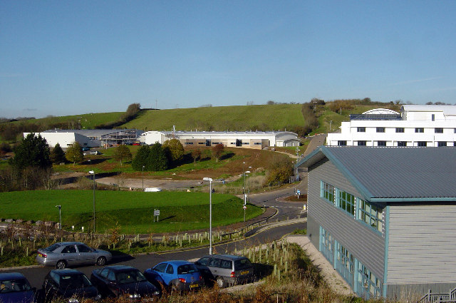
South Devon College

South Devon College is a further education college with 9 different campuses within Torbay and the surrounding area. The college is part of The University...

Galmpton, Torbay

Galmpton is a semi-rural village in Torbay, in the ceremonial county of Devon, England. It is located in the ward of Churston-with-Galmpton and the historic...

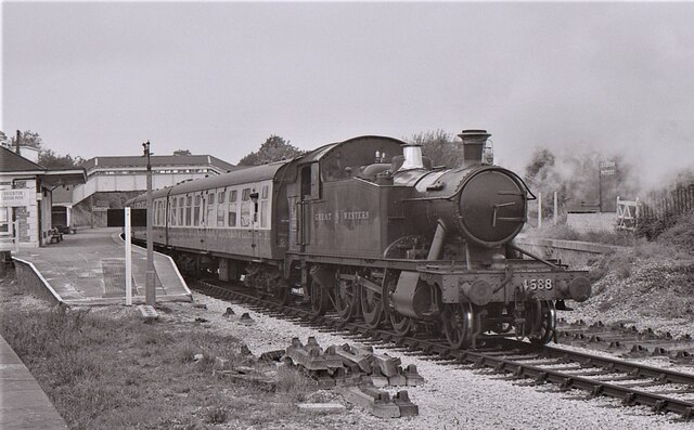
Greenway Halt railway station (Devon)

Greenway Halt railway station is a small railway station on the Dartmouth Steam Railway, a heritage railway in Devon, England. It is situated near the...

Nearby Amenities

Located within 500m of 50.401108,-3.584368
Waddeton
Is In: Devon, England, UK
Place: hamlet
Lat/Long: 50.4012778/-3.587067
Post Box
Brand: Royal Mail
Brand Wikidata: Q638098
Brand Wikipedia: en:Royal Mail
Collection Times: Mo-Fr 16:00; Sa 09:30; Su off
Operator: Royal Mail
Operator Wikidata: Q638098
Post Box Design: type_c
Post Box Mounting: stone_wall
Post Box Type: wall
Ref: TQ5 66
Royal Cypher: VR
Royal Cypher Wikidata: Q33102356
Source: survey;streetlevel imagery;aerial imagery
Lat/Long: 50.4008134/-3.5867313
The data included in this document is from www.openstreetmap.org. The data is made available under ODbL.

Have you been to Waddeton?

Leave your review of Waddeton below (or comments, questions and feedback).