Eastern Cleave Plantations

Wood, Forest in Devon Teignbridge

England

Eastern Cleave Plantations

Old Boundary Marker on Lower Down. Bovey Tracey Estate Boundary Marker against a wire fence on the northwest side of the track to Reddaford Water 400 metres northeast of the B3387, in Bovey Tracey parish. Inscribed SHEWTE / RIGHT(S), it marks grazing rights for Shewte Estate on Lower Down of Yarner Down.

Milestone Society National ID: DV_HTTW04em
Old Boundary Marker on Lower Down. Bovey Tracey Credit: T Jenkinson

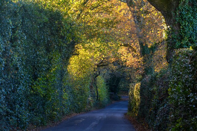
Eastern Cleave Plantations, located in Devon, is a sprawling wood and forest area known for its natural beauty and diverse flora and fauna. Covering an extensive area of land, the plantations are a popular destination for nature enthusiasts, hikers, and those seeking tranquility away from the bustling city life.

The woodlands of Eastern Cleave Plantations are characterized by their dense tree cover, predominantly consisting of native species such as oak, beech, and ash. These trees provide a haven for a wide variety of wildlife, including deer, foxes, and various bird species. The plantations are also home to a number of rare and protected species, making it an important conservation site.

Visitors to Eastern Cleave Plantations can explore the woodlands through a network of well-maintained trails and paths, allowing them to immerse themselves in the natural surroundings. The area offers a mix of easy and more challenging routes, catering to different fitness levels and preferences. Along the trails, visitors can enjoy breathtaking views, discover hidden ponds, and observe the rich biodiversity that thrives within the plantations.

Moreover, Eastern Cleave Plantations is committed to sustainable forest management practices, ensuring the preservation of this valuable natural resource for future generations. The management team regularly conducts tree planting initiatives, wildlife surveys, and habitat restoration projects to enhance the ecological balance of the area.

In conclusion, Eastern Cleave Plantations in Devon offers a captivating experience for nature lovers, with its picturesque woodlands, diverse wildlife, and commitment to conservation. Whether it's a leisurely stroll or an adventurous hike, visitors are guaranteed an unforgettable encounter with the serene beauty of this natural haven.

If you have any feedback on the listing, please let us know in the comments section below.

Eastern Cleave Plantations Images

Images are sourced within 2km of 50.581289/-3.7061926 or Grid Reference SX7977. Thanks to Geograph Open Source API. All images are credited.

Old Boundary Marker on Lower Down. Bovey Tracey Estate Boundary Marker against a wire fence on the northwest side of the track to Reddaford Water 400 metres northeast of the B3387, in Bovey Tracey parish. Inscribed SHEWTE / RIGHT(S), it marks grazing rights for Shewte Estate on Lower Down of Yarner Down.

Milestone Society National ID: DV_HTTW04em
Old Boundary Marker on Lower Down. Bovey Tracey
Estate Boundary Marker against a wire fence on the northwest side of the track to Reddaford Water 400 metres northeast of the B3387, in Bovey Tracey parish. Inscribed SHEWTE / RIGHT(S), it marks grazing rights for Shewte Estate on Lower Down of Yarner Down. Milestone Society National ID: DV_HTTW04em
Lewthorn Cross Road junction a little to the west of Ilsington village.
There have been a couple of changes since Alex McGregor photographed this junction in 2015 - the post box is gone, and the signpost has grown a new arm - see <a href="https://www.geograph.org.uk/photo/4308310">SX7776 : Lewthorne cross</a>.
Lewthorn Cross
Road junction a little to the west of Ilsington village. There have been a couple of changes since Alex McGregor photographed this junction in 2015 - the post box is gone, and the signpost has grown a new arm - see SX7776 : Lewthorne cross.
Very minor road Any modern motor vehicle would brush the vegetation on both sides of this minor road between Lewthorn Cross and Trumpeter.
Very minor road
Any modern motor vehicle would brush the vegetation on both sides of this minor road between Lewthorn Cross and Trumpeter.
Grazing land Cattle pasture between Haytor Vale and Ilsington.
Grazing land
Cattle pasture between Haytor Vale and Ilsington.
South through Green Lane Green Lane is a small settlement east of Haytor Vale.
South through Green Lane
Green Lane is a small settlement east of Haytor Vale.
Cattle grid The road descends into Green Lane village.
Cattle grid
The road descends into Green Lane village.
Green Lane End The signpost is at the junction with the B3387. The road on the right descends into Green Lane village.
Green Lane End
The signpost is at the junction with the B3387. The road on the right descends into Green Lane village.
Path, Lodge Wood Bovey Tracey footpath 1 climbs along the upper edge of the wood. There's low cloud, some of which seems to have crept into the wood.
Path, Lodge Wood
Bovey Tracey footpath 1 climbs along the upper edge of the wood. There's low cloud, some of which seems to have crept into the wood.
Bovey Tracey : Road Looking down towards the road.
Bovey Tracey : Road
Looking down towards the road.
Bovey Tracey : Road A road junction.
Bovey Tracey : Road
A road junction.
Bovey Tracey : Gate A gate leading to Reddaford water pumping station.
Bovey Tracey : Gate
A gate leading to Reddaford water pumping station.
Bovey Tracey : Country Road Looking along a country road.
Bovey Tracey : Country Road
Looking along a country road.
Bovey Tracey : Road Looking along a road.
Bovey Tracey : Road
Looking along a road.
Bovey Tracey : Dartmoor Sign A sign welcoming people onto Dartmoor.
Bovey Tracey : Dartmoor Sign
A sign welcoming people onto Dartmoor.
Bovey Tracey : Road A road heading through the countryside.
Bovey Tracey : Road
A road heading through the countryside.
Bovey Tracey : Moor Croft House A house in the countryside.
Bovey Tracey : Moor Croft House
A house in the countryside.
Bovey Tracey : Road A road heads through the countryside.
Bovey Tracey : Road
A road heads through the countryside.
Bovey Tracey : Countryside Scenery Looking across the rolling hills.
Bovey Tracey : Countryside Scenery
Looking across the rolling hills.
Show me another place!

Eastern Cleave Plantations is located at Grid Ref: SX7977 (Lat: 50.581289, Lng: -3.7061926)

Administrative County: Devon

District: Teignbridge

Police Authority: Devon and Cornwall

What 3 Words

///ditched.golden.evaporate. Near Bovey Tracey, Devon

Related Wikis

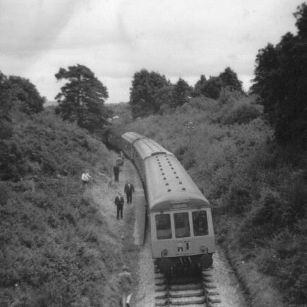
Brimley Halt railway station

Brimley Halt was a railway station open in 1928 by the Great Western Railway (GWR) to serve the village of Brimley that lies between Bovey Tracey and Ilsington...

Yarner Wood & Trendlebere Down

Yarner Wood & Trendlebere Down in Dartmoor, Devon, England is a woodland managed by Natural England. The woodland is part of the East Dartmoor Woods and...

Bovey railway station

Bovey railway station sometimes known as Bovey for Ilsington was on the Moretonhampstead and South Devon Railway at Bovey Tracey, Devon, England. The station...

Bovey Tracey A.F.C.

Bovey Tracey Association Football Club is a football club based in Bovey Tracey, Devon, England. They are currently members of the South West Peninsula...

Nearby Amenities

Located within 500m of 50.581289,-3.7061926
Generator Method: photovoltaic
Generator Output Electricity: yes
Generator Source: solar
Generator Type: solar_photovoltaic_panel
Location: roof
Power: generator
Lat/Long: 50.5781816/-3.7014484
Power: pole
Lat/Long: 50.5852002/-3.7055241
Power: pole
Lat/Long: 50.5849597/-3.7063952
Power: pole
Lat/Long: 50.5847192/-3.7073617
Power: pole
Lat/Long: 50.5843763/-3.708552
Power: pole
Lat/Long: 50.5840733/-3.7096229
Power: pole
Lat/Long: 50.5840789/-3.7103388
Power: pole
Lat/Long: 50.5840789/-3.7116693
The data included in this document is from www.openstreetmap.org. The data is made available under ODbL.

Have you been to Eastern Cleave Plantations?

Leave your review of Eastern Cleave Plantations below (or comments, questions and feedback).