Alder Wood

Wood, Forest in Devon Teignbridge

England

Alder Wood

Old Boundary Marker on Haytor Down Parish Boundary Marker on Haytor Down 36 metres east of the road from Haytor Vale to Water. Inscribed Wm / STONE and 1853 on opposite faces. Called the William Stone or Old William, it was erected to mark the boundary of Ilsington and Bovey Tracey parishes. In 1853 the Duke of Somerset, as Lord of the Manor of Ilsington had the stone inscribed to mark the boundary of the manor.

Milestone Society National ID: DV_BTWSpb
Old Boundary Marker on Haytor Down Credit: T Jenkinson

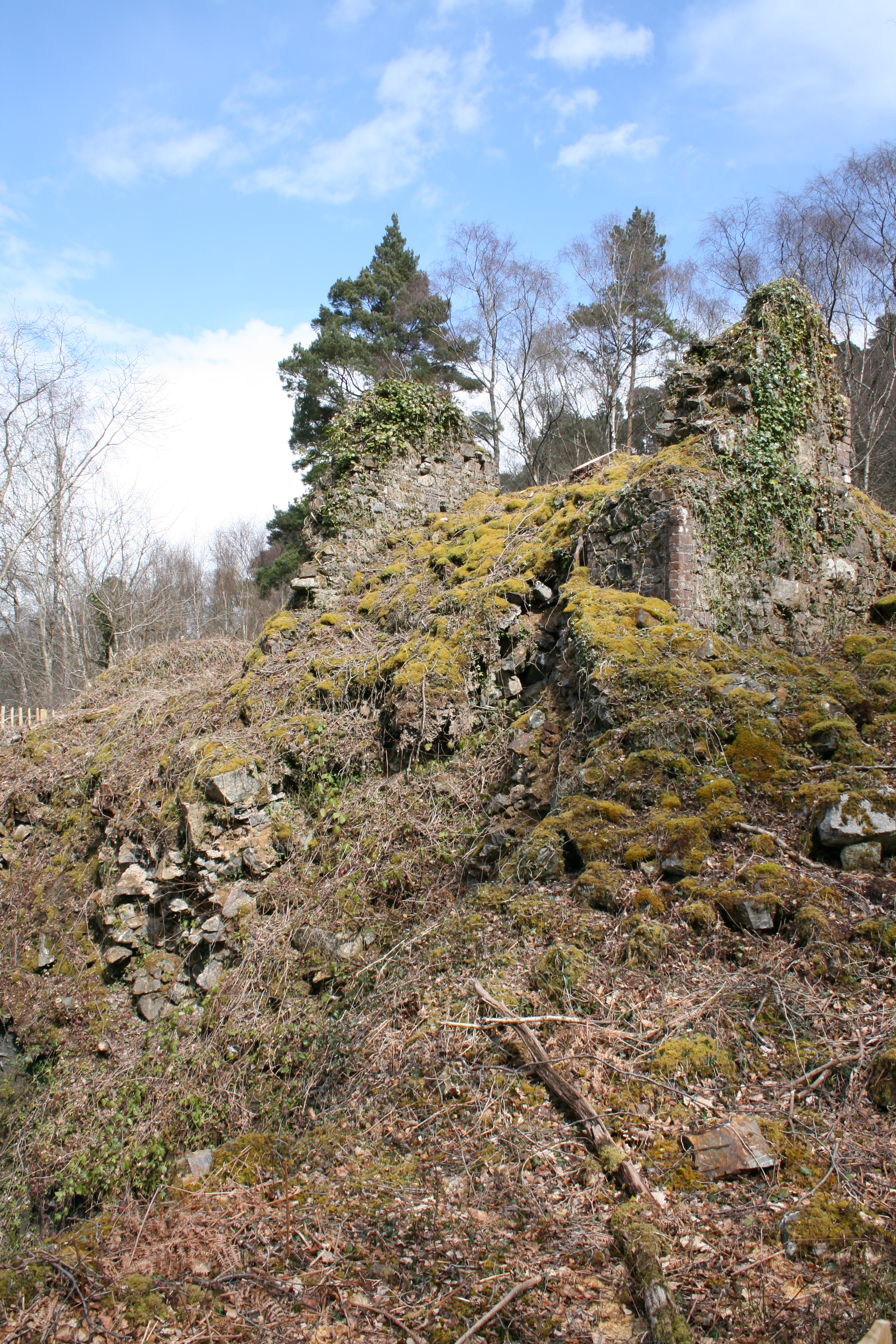
Alder Wood is a picturesque forest located in Devon, England. Stretching over a vast area, this woodland is home to an abundance of alder trees, which give the forest its name. The forest is situated in a rural area, offering a tranquil and peaceful atmosphere for visitors to enjoy.

The alder trees dominate the landscape, with their slender trunks and distinctive dark green leaves. These trees thrive in the damp and wet conditions found in the forest, as it is situated close to several streams and rivers. The alder trees' roots help stabilize the soil, preventing erosion and providing a protective habitat for a variety of wildlife.

Alder Wood is a haven for nature enthusiasts, as it is home to a diverse range of flora and fauna. The forest floor is carpeted with a rich assortment of wildflowers, including bluebells and primroses, creating a vibrant and colorful display during the spring months. The forest also provides a habitat for a wide array of bird species, including woodpeckers and owls, which can often be spotted darting between the trees.

For those looking to explore the forest, there are several well-marked trails and footpaths that wind their way through the woodland. These paths offer visitors the opportunity to immerse themselves in the natural beauty of Alder Wood while enjoying a leisurely walk or hike. Additionally, the forest is equipped with picnic areas and benches, making it an ideal spot for a peaceful outdoor lunch or rest.

Overall, Alder Wood is a charming and enchanting forest in Devon, offering a serene escape from the hustle and bustle of everyday life. Whether it's for a leisurely stroll, birdwatching, or simply enjoying the beauty of nature, this woodland is a must-visit destination for nature lovers and outdoor enthusiasts alike.

If you have any feedback on the listing, please let us know in the comments section below.

Alder Wood Images

Images are sourced within 2km of 50.582902/-3.7114492 or Grid Reference SX7877. Thanks to Geograph Open Source API. All images are credited.

Old Boundary Marker on Haytor Down Parish Boundary Marker on Haytor Down 36 metres east of the road from Haytor Vale to Water. Inscribed Wm / STONE and 1853 on opposite faces. Called the William Stone or Old William, it was erected to mark the boundary of Ilsington and Bovey Tracey parishes. In 1853 the Duke of Somerset, as Lord of the Manor of Ilsington had the stone inscribed to mark the boundary of the manor.

Milestone Society National ID: DV_BTWSpb
Old Boundary Marker on Haytor Down
Parish Boundary Marker on Haytor Down 36 metres east of the road from Haytor Vale to Water. Inscribed Wm / STONE and 1853 on opposite faces. Called the William Stone or Old William, it was erected to mark the boundary of Ilsington and Bovey Tracey parishes. In 1853 the Duke of Somerset, as Lord of the Manor of Ilsington had the stone inscribed to mark the boundary of the manor. Milestone Society National ID: DV_BTWSpb
Old Boundary Marker on Lower Down. Bovey Tracey Estate Boundary Marker against a wire fence on the northwest side of the track to Reddaford Water 400 metres northeast of the B3387, in Bovey Tracey parish. Inscribed SHEWTE / RIGHT(S), it marks grazing rights for Shewte Estate on Lower Down of Yarner Down.

Milestone Society National ID: DV_HTTW04em
Old Boundary Marker on Lower Down. Bovey Tracey
Estate Boundary Marker against a wire fence on the northwest side of the track to Reddaford Water 400 metres northeast of the B3387, in Bovey Tracey parish. Inscribed SHEWTE / RIGHT(S), it marks grazing rights for Shewte Estate on Lower Down of Yarner Down. Milestone Society National ID: DV_HTTW04em
Cottages in Haytor Vale Haytor Vale is a village located in the eastern section of Dartmoor below Haytor Rocks.
Cottages in Haytor Vale
Haytor Vale is a village located in the eastern section of Dartmoor below Haytor Rocks.
Cottages in Haytor Vale The Rock Inn stands centrally in this row of cottages in the village.
Cottages in Haytor Vale
The Rock Inn stands centrally in this row of cottages in the village.
Haytor Vale WI Lodge A news article on the Rendells Estate Agency website, dated 17th June 2021, reads thus: 
'Rendells Commercial department at Newton Abbot are pleased to report another successful auction. They were pleased to be instructed by The Trustees of The Haytor Vale W.I. Hut to value and sell their premises at Haytor Vale within The Dartmoor National Park. The Hut was erected for the members in 1934 by the respected Newton Abbot builders Kennards and the hut has been in continual use by The Haytor Vale W.I. since that date. They have maintained the building and modernized where required over the years and the building is a fine example of its type that shows little sign of age. The property was offered for sale by Auction at the Jolly Farmer Newton Abbot on the 16th of June and the auction was well attended with a number of the W.I. members present. The bidding started at £75,000 which steadily rose to the final bid where the property was sold at £114.000. The members expressed their pleasure at the sum realised which will help them with their future ventures from their new base at The Ilsington Village Hall'.
Haytor Vale WI Lodge
A news article on the Rendells Estate Agency website, dated 17th June 2021, reads thus: 'Rendells Commercial department at Newton Abbot are pleased to report another successful auction. They were pleased to be instructed by The Trustees of The Haytor Vale W.I. Hut to value and sell their premises at Haytor Vale within The Dartmoor National Park. The Hut was erected for the members in 1934 by the respected Newton Abbot builders Kennards and the hut has been in continual use by The Haytor Vale W.I. since that date. They have maintained the building and modernized where required over the years and the building is a fine example of its type that shows little sign of age. The property was offered for sale by Auction at the Jolly Farmer Newton Abbot on the 16th of June and the auction was well attended with a number of the W.I. members present. The bidding started at £75,000 which steadily rose to the final bid where the property was sold at £114.000. The members expressed their pleasure at the sum realised which will help them with their future ventures from their new base at The Ilsington Village Hall'.
Cottamoor Cross This junction, just south of Haytor Vale village, is named as a cross, even though it is only a t-junction.
Cottamoor Cross
This junction, just south of Haytor Vale village, is named as a cross, even though it is only a t-junction.
Gated track Looking east from a little way south of Haytor Vale village.
Gated track
Looking east from a little way south of Haytor Vale village.
Tor Garage Offering a range of garage services from its very rural location.
Tor Garage
Offering a range of garage services from its very rural location.
Lewthorn Cross Road junction a little to the west of Ilsington village.
There have been a couple of changes since Alex McGregor photographed this junction in 2015 - the post box is gone, and the signpost has grown a new arm - see <a href="https://www.geograph.org.uk/photo/4308310">SX7776 : Lewthorne cross</a>.
Lewthorn Cross
Road junction a little to the west of Ilsington village. There have been a couple of changes since Alex McGregor photographed this junction in 2015 - the post box is gone, and the signpost has grown a new arm - see SX7776 : Lewthorne cross.
Very minor road Any modern motor vehicle would brush the vegetation on both sides of this minor road between Lewthorn Cross and Trumpeter.
Very minor road
Any modern motor vehicle would brush the vegetation on both sides of this minor road between Lewthorn Cross and Trumpeter.
Grazing land Cattle pasture between Haytor Vale and Ilsington.
Grazing land
Cattle pasture between Haytor Vale and Ilsington.
South through Green Lane Green Lane is a small settlement east of Haytor Vale.
South through Green Lane
Green Lane is a small settlement east of Haytor Vale.
Cattle grid The road descends into Green Lane village.
Cattle grid
The road descends into Green Lane village.
Green Lane End The signpost is at the junction with the B3387. The road on the right descends into Green Lane village.
Green Lane End
The signpost is at the junction with the B3387. The road on the right descends into Green Lane village.
Path, Lodge Wood Bovey Tracey footpath 1 climbs along the upper edge of the wood. There's low cloud, some of which seems to have crept into the wood.
Path, Lodge Wood
Bovey Tracey footpath 1 climbs along the upper edge of the wood. There's low cloud, some of which seems to have crept into the wood.
Bovey Tracey : Track A track heads through the open land.
Bovey Tracey : Track
A track heads through the open land.
Bovey Tracey : Track A track heads across the open land.
Bovey Tracey : Track
A track heads across the open land.
Bovey Tracey : Track A track heads across the open land.
Bovey Tracey : Track
A track heads across the open land.
Show me another place!

Alder Wood is located at Grid Ref: SX7877 (Lat: 50.582902, Lng: -3.7114492)

Administrative County: Devon

District: Teignbridge

Police Authority: Devon and Cornwall

What 3 Words

///helpless.badly.listen. Near Bovey Tracey, Devon

Related Wikis

Yarner Wood & Trendlebere Down

Yarner Wood & Trendlebere Down in Dartmoor, Devon, England is a woodland managed by Natural England. The woodland is part of the East Dartmoor Woods and...

Brimley Halt railway station

Brimley Halt was a railway station open in 1928 by the Great Western Railway (GWR) to serve the village of Brimley that lies between Bovey Tracey and Ilsington...

Ilsington

Ilsington is a village and civil parish situated on the eastern edge of Dartmoor, Devon, England. It is one of the largest parishes in the county, and...

Bovey railway station

Bovey railway station sometimes known as Bovey for Ilsington was on the Moretonhampstead and South Devon Railway at Bovey Tracey, Devon, England. The station...

Bovey Tracey A.F.C.

Bovey Tracey Association Football Club is a football club based in Bovey Tracey, Devon, England. They are currently members of the South West Peninsula...

Pullabrook Halt railway station

Pullabrook Halt was a railway station opened in 1931 by the Great Western Railway to serve the hamlet of Pullabrook that lies between Bovey Tracey and...

Indio, Bovey Tracey

Indio (anciently Indehoe, Indiho, etc.) in the parish of Bovey Tracey in Devon, is an historic estate. The present large mansion house, known as Indio...

River Lemon

The River Lemon is a 9.9 miles (15.9 kilometres) river in the county of Devon in southwest England. It is a tributary of the River Teign, starting on Dartmoor...

Nearby Amenities

Located within 500m of 50.582902,-3.7114492
Colehayes Park (Field Studies Centre)
Place: hamlet
Lat/Long: 50.5859332/-3.708462
Generator Method: photovoltaic
Generator Output Electricity: yes
Generator Source: solar
Generator Type: solar_photovoltaic_panel
Location: roof
Power: generator
Lat/Long: 50.5813662/-3.7176939
Generator Method: photovoltaic
Generator Output Electricity: yes
Generator Source: solar
Generator Type: solar_photovoltaic_panel
Location: roof
Power: generator
Lat/Long: 50.580739/-3.7176517
Power: pole
Lat/Long: 50.5852002/-3.7055241
Power: pole
Lat/Long: 50.5849597/-3.7063952
Power: pole
Lat/Long: 50.5847192/-3.7073617
Power: pole
Lat/Long: 50.5843763/-3.708552
Power: pole
Lat/Long: 50.5840733/-3.7096229
Power: pole
Lat/Long: 50.5840789/-3.7103388
Power: pole
Lat/Long: 50.5840789/-3.7116693
Power: pole
Lat/Long: 50.5840808/-3.712609
Power: pole
Lat/Long: 50.5840771/-3.7139216
Power: pole
Lat/Long: 50.5840789/-3.7151774
Power: pole
Lat/Long: 50.5840752/-3.716135
Power: pole
Lat/Long: 50.5840733/-3.717206
The data included in this document is from www.openstreetmap.org. The data is made available under ODbL.

Have you been to Alder Wood?

Leave your review of Alder Wood below (or comments, questions and feedback).