Radsbury Copse

Wood, Forest in Devon North Devon

England

Radsbury Copse

The B3234 at the A39 at Barbrook
The B3234 at the A39 at Barbrook Credit: Roy Hughes

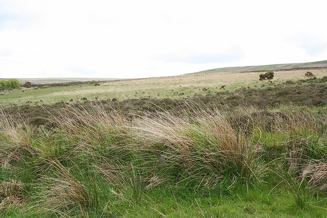
Radsbury Copse is a picturesque wood located in the county of Devon, England. Situated near the village of Radsbury, this forested area covers a vast expanse of land, providing a peaceful retreat for nature enthusiasts and hikers alike.

The copse is characterized by its dense woodland, with towering trees that create a lush and green canopy overhead. The variety of tree species found in Radsbury Copse includes oak, beech, ash, and birch, among others, creating a diverse and vibrant ecosystem. The forest floor is covered in a thick layer of fallen leaves and moss, offering a soft and cushioned path for visitors to explore.

Trails wind their way through the copse, providing opportunities for leisurely strolls or more challenging hikes. These paths are well-maintained, making it accessible for people of all ages and fitness levels. Along the way, visitors can admire the vibrant flora and fauna that call Radsbury Copse their home. Squirrels scurry through the branches, birds chirp melodiously, and if one is particularly lucky, they may even catch a glimpse of a deer gracefully roaming through the undergrowth.

Radsbury Copse is not only a haven for wildlife but also a place of tranquility for those seeking solitude. The peaceful ambiance and natural beauty make it an ideal location for meditation, photography, or simply escaping the hustle and bustle of daily life. The copse is also a popular spot for picnics, with designated areas equipped with benches and tables for visitors to enjoy a meal amidst the serene surroundings.

Overall, Radsbury Copse in Devon offers a serene and enchanting woodland experience, inviting visitors to immerse themselves in the beauty of nature.

If you have any feedback on the listing, please let us know in the comments section below.

Radsbury Copse Images

Images are sourced within 2km of 51.200628/-3.8394993 or Grid Reference SS7146. Thanks to Geograph Open Source API. All images are credited.

The B3234 at the A39 at Barbrook
Brendon: Shilston Hill from Cheriton Shilstone Hill carries the road south from Lynmouth to Simonsbath
Brendon: Shilston Hill from Cheriton
Shilstone Hill carries the road south from Lynmouth to Simonsbath
Barbrook Post Office Barbrook is a pretty little village on the West Lyn River.
Barbrook Post Office
Barbrook is a pretty little village on the West Lyn River.
Roborough Castle Sheep now invade this bronze age enclosure.
Roborough Castle
Sheep now invade this bronze age enclosure.
Lynton & Lynmouth: Durcombe Water A private garden which is open to the public for three Sunday afternoons in 2006 under the National Garden Scheme, and otherwise by appointment. It features waterfalls and eight tiered ponds. The Durcombe Water is a tributary of the West Lyn River and the garden borders Exmoor’s open moorland. Looking east-north-east
Lynton & Lynmouth: Durcombe Water
A private garden which is open to the public for three Sunday afternoons in 2006 under the National Garden Scheme, and otherwise by appointment. It features waterfalls and eight tiered ponds. The Durcombe Water is a tributary of the West Lyn River and the garden borders Exmoor’s open moorland. Looking east-north-east
Lynton & Lynmouth: North Furzehill On the bridleway to Shallowford. Looking east
Lynton & Lynmouth: North Furzehill
On the bridleway to Shallowford. Looking east
Lynton & Lynmouth: North Furzehill Restored overshot waterwheel which carries the legend ‘Garnish & Lemon Barnstaple’ – a firm of millwrights operating from Pilton in the late 19th century – on the shrouds. Seen from the bridleway from Shallowford. Looking north east
Lynton & Lynmouth: North Furzehill
Restored overshot waterwheel which carries the legend ‘Garnish & Lemon Barnstaple’ – a firm of millwrights operating from Pilton in the late 19th century – on the shrouds. Seen from the bridleway from Shallowford. Looking north east
Lynton & Lynmouth: by the bridleway to Shallowford Looking south-south-east below Ilkerton Ridge
Lynton & Lynmouth: by the bridleway to Shallowford
Looking south-south-east below Ilkerton Ridge
Lynton & Lynmouth: bridleway to Cheriton Looking east-south-east by the lane to North Furzehill
Lynton & Lynmouth: bridleway to Cheriton
Looking east-south-east by the lane to North Furzehill
Lynton & Lynmouth: West Lyn valley Looking west-north-west towards Manor Farm, East Ilkerton. Seen from a point on the lane north of Sparhanger Cross
Lynton & Lynmouth: West Lyn valley
Looking west-north-west towards Manor Farm, East Ilkerton. Seen from a point on the lane north of Sparhanger Cross
Lynton & Lynmouth: valley below Dean Seen from the Dean layby on the A39 Lynmouth to Blackmoor Gate road. Looking south-south-west
Lynton & Lynmouth: valley below Dean
Seen from the Dean layby on the A39 Lynmouth to Blackmoor Gate road. Looking south-south-west
Standing stones on Lyn Down Two standing stones on Lyn Down. The coast of South Wales can just be seen in the distance.
Standing stones on Lyn Down
Two standing stones on Lyn Down. The coast of South Wales can just be seen in the distance.
Bridge over Barbrook on Exmoor
Exmoor Edge. View looking West towards Barham Hill, middle distance raised ground. Exmoor boundary is 100m from the viewpoint.
Exmoor Edge.
View looking West towards Barham Hill, middle distance raised ground. Exmoor boundary is 100m from the viewpoint.
Shallowford The hedgeline, left, is Exmoor boundary.
Shallowford
The hedgeline, left, is Exmoor boundary.
Barbrook Bridge This is a reverse angle view of Rachel Hunt's picture.
Barbrook Bridge
This is a reverse angle view of Rachel Hunt's picture.
Road to Thornworthy Signpost reads:
Right:
Public Bridleway
Martinhoe Cross A39
Via Thornworthy &
Woolhanger 2¼

Left:
Sparhanger
Cross
Road to Thornworthy
Signpost reads: Right: Public Bridleway Martinhoe Cross A39 Via Thornworthy & Woolhanger 2¼ Left: Sparhanger Cross
Thornworthy From the path to High Bullen.
Thornworthy
From the path to High Bullen.
Show me another place!

Radsbury Copse is located at Grid Ref: SS7146 (Lat: 51.200628, Lng: -3.8394993)

Administrative County: Devon

District: North Devon

Police Authority: Devon and Cornwall

What 3 Words

///progress.butchers.newspaper. Near Lynton, Devon

Related Wikis

Shallowford, Devon

Shallowford is a hamlet in the civil parish of Lynton and Lynmouth in the North Devon district of Devon, England. Its nearest town is Lynton, which lies...

Roborough Castle

Roborough Castle is an Iron Age enclosure or hill fort situated close to Lynton in Devon, England. The fort is situated on the North East edge of a Hillside...

Barbrook

Barbrook is a village in Devon, England. It is close to the source of the West Lyn River. The village post office and shop closed on 27 September 2008...

Furzehill, Devon

Furzehill is a hamlet in the North Devon district of Devon, England. Its nearest town is Lynton, which lies approximately 4 miles (6.4 km) north from the...

Nearby Amenities

Located within 500m of 51.200628,-3.8394993
Ford: yes
Lat/Long: 51.1992956/-3.8367435
The data included in this document is from www.openstreetmap.org. The data is made available under ODbL.

Have you been to Radsbury Copse?

Leave your review of Radsbury Copse below (or comments, questions and feedback).