Chipping Campden

Settlement in Gloucestershire Cotswold

England

Chipping Campden

Road junction on the B4081 Country road junction with the B4081 above Chipping Campden.
Road junction on the B4081 Credit: Philip Halling

Chipping Campden is a historic market town located in the Cotswold district of Gloucestershire, England. With its picturesque honey-colored stone buildings, Chipping Campden is widely regarded as one of the most beautiful towns in the Cotswolds and attracts visitors from around the world.

The town's history dates back to the 14th century when it was an important center for the wool trade. Many of the buildings in Chipping Campden reflect this prosperous past, including the iconic Market Hall, which was built in 1627 and still stands as a reminder of the town's market heritage.

The town is known for its vibrant arts and crafts scene, with numerous galleries and workshops showcasing the work of local artists and artisans. Visitors can explore the town's rich artistic heritage by visiting the Court Barn Museum, which houses a collection of furniture, textiles, and other crafts from the Arts and Crafts movement.

Chipping Campden is also a popular destination for walkers and nature enthusiasts, with a network of footpaths and trails that lead through the surrounding Cotswold countryside. One of the most famous walks is the Cotswold Way, a long-distance trail that passes through the town.

In addition to its natural beauty and cultural offerings, Chipping Campden offers a range of amenities, including charming tea rooms, traditional pubs, and boutique shops. The town's annual events, such as the Cotswold Olimpicks and the Chipping Campden Music Festival, attract visitors throughout the year.

Overall, Chipping Campden offers a captivating blend of history, natural beauty, and cultural attractions that make it a must-visit destination for anyone exploring the Cotswolds.

If you have any feedback on the listing, please let us know in the comments section below.

Chipping Campden Images

Images are sourced within 2km of 52.050229/-1.781781 or Grid Reference SP1539. Thanks to Geograph Open Source API. All images are credited.

Road junction on the B4081 Country road junction with the B4081 above Chipping Campden.
Road junction on the B4081
Country road junction with the B4081 above Chipping Campden.
Train approaching the Campden Tunnel A train having left Moreton-in-Marsh is now approaching the south portal of the Campden Tunnel.
Train approaching the Campden Tunnel
A train having left Moreton-in-Marsh is now approaching the south portal of the Campden Tunnel.
Campden Tunnel, South Portal The south portal of the 811m long Campden Tunnel on the Cotswold line between Oxford and Worcester.  The line opened in 1851 and was engineered by Isambard Kingdom Brunel.
Campden Tunnel, South Portal
The south portal of the 811m long Campden Tunnel on the Cotswold line between Oxford and Worcester. The line opened in 1851 and was engineered by Isambard Kingdom Brunel.
South portal, Campden Tunnel The south portal of the 811m long Campden Tunnel on the Cotswold line between Oxford and Worcester.  The line opened in 1851 and was engineered by Isambard Kingdom Brunel.
South portal, Campden Tunnel
The south portal of the 811m long Campden Tunnel on the Cotswold line between Oxford and Worcester. The line opened in 1851 and was engineered by Isambard Kingdom Brunel.
Farmland above Chipping Campden The tower of Chipping Campden church can be seen over the brow of the hill.
Farmland above Chipping Campden
The tower of Chipping Campden church can be seen over the brow of the hill.
Farm buildings near Chipping Campden Farm buildings near Chipping Campden, viewed from Furze Lane.
Farm buildings near Chipping Campden
Farm buildings near Chipping Campden, viewed from Furze Lane.
Tree-lined drive, Mickleton Hills Farm Tree-lined drive to Mickleton Hills Farm, two long distance paths follow this drive, the Monarch's Way and the Heart of England Way.
Tree-lined drive, Mickleton Hills Farm
Tree-lined drive to Mickleton Hills Farm, two long distance paths follow this drive, the Monarch's Way and the Heart of England Way.
Sticky bud An opening sticky bud on a horse chestnut tree.
Sticky bud
An opening sticky bud on a horse chestnut tree.
Horse chestnut leaves Newly opened leaves on a horse chestnut tree.
Horse chestnut leaves
Newly opened leaves on a horse chestnut tree.
Footpath to Chipping Campden The footpath to Chipping Campden leaves Furze Lane heading SSE.
Footpath to Chipping Campden
The footpath to Chipping Campden leaves Furze Lane heading SSE.
Field of barley A field of barley north east of B4035 Aston Road.
Field of barley
A field of barley north east of B4035 Aston Road.
Stubble field south of Furze Lane A recently harvested, now stubble, field south of Furze Lane.
Stubble field south of Furze Lane
A recently harvested, now stubble, field south of Furze Lane.
Narrow lane with passing places Furze Lane is narrow with occasional small passing places.
Narrow lane with passing places
Furze Lane is narrow with occasional small passing places.
View towards Chipping Campden Looking SSE from the junction of Campden Road and Furze Lane, across a recently harvested field towards the Church of St. James in Chipping Campden at <a href="https://www.geograph.org.uk/gridref/SP154394">SP154394</a>.
View towards Chipping Campden
Looking SSE from the junction of Campden Road and Furze Lane, across a recently harvested field towards the Church of St. James in Chipping Campden at SP154394.
Junction of Campden Road and Furze Lane Opposite is the driveway to Attlepin Farm, also a bridleway.
Junction of Campden Road and Furze Lane
Opposite is the driveway to Attlepin Farm, also a bridleway.
Speed limit signs approaching Paul's Pike Cottages The speed limit on the B4035 Aston Road is reduced to 40 mph, approaching the junction with the B4081 Campden Road at Paul's Pike Cottages.
Speed limit signs approaching Paul's Pike Cottages
The speed limit on the B4035 Aston Road is reduced to 40 mph, approaching the junction with the B4081 Campden Road at Paul's Pike Cottages.
Bridleway to Dover's Hill The bridleway leaves the B4035 Aston Road, heading SSW up Dover's Hill.
The sign on the gate reminds walkers not to park here.
Bridleway to Dover's Hill
The bridleway leaves the B4035 Aston Road, heading SSW up Dover's Hill. The sign on the gate reminds walkers not to park here.
Show me another place!

Chipping Campden is located at Grid Ref: SP1539 (Lat: 52.050229, Lng: -1.781781)

Administrative County: Gloucestershire

District: Cotswold

Police Authority: Gloucestershire

What 3 Words

///hammer.synthetic.youths. Near Chipping Campden, Gloucestershire

Related Wikis

Chipping Campden Town Hall

Chipping Campden Town Hall is a municipal building in the High Street, Chipping Campden, Gloucestershire, England. The building, which is the meeting place...

Guild and School of Handicraft

The Guild and School of Handicraft was established in 1888 in London, later moving to Chipping Campden in Gloucestershire, England, as a community of artists...

Chipping Campden

Chipping Campden is a market town in the Cotswold district of Gloucestershire, England. It is notable for its terraced High Street, dating from the 14th...

North Cotswold Community Radio

North Cotswold Community Radio is a non-profit community internet radio station serving primarily the North Cotswolds and the surrounding area in west...

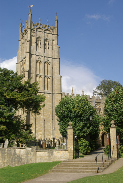
Church of St James, Chipping Campden

The Anglican Church of St James at Chipping Campden in the Cotswold District of Gloucestershire, England was built in the 15th century incorporating an...

Chipping Campden School

Chipping Campden School is a non-selective secondary school and sixth form with academy status located in Chipping Campden, in the English county of Gloucestershire...

Ernest Wilson Memorial Garden

Ernest Wilson Memorial Garden is located at the north eastern edge of Chipping Campden in Gloucestershire, England, in an area of the High Street known...
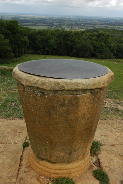
Dover's Hill

Dover's Hill is a 754 feet (230 metres) hill in the Cotswolds area of central England. The hill is 1 mile (1.6 km) north-west of Chipping Campden in Gloucestershire...

Nearby Amenities

Located within 500m of 52.050229,-1.781781
Chipping Campden
Is In Country: United Kingdom
Is In Country Code: GB
Is In County: Gloucestershire
Place: town
Population: 2200
Postal Code: GL55
Wikidata: Q767811
Wikipedia: en:Chipping Campden
Lat/Long: 52.0496652/-1.7813927
Post Office
Chipping Campden Post Office
Addr City: Chipping Campden
Addr Country: GB
Addr Housename: The Cambrook
Addr Postcode: GL55 6AT
Addr Street: High Street
Addr Unit: 2C
Fixme: Check location
Opening Hours: Mo-Sa 09:00-17:30; Su 10:00-16:00
Ref Pol Id: 167346
Wikidata: Q26467200
Lat/Long: 52.0505145/-1.7807253
Parking
Parking: surface
Source: survey
Lat/Long: 52.0505911/-1.7851329
Noel Arms Hotel
Addr City: Chipping Campden
Addr Postcode: GL55 6AT
Addr Street: High Street
Fhrs Id: 75029
Source: survey
Tourism: hotel
Website: https://noelarmshotel.com/
Wikidata: Q26348258
Lat/Long: 52.0502537/-1.7813868
Barrier: narrows
Lat/Long: 52.0499434/-1.7809656
Post Box
Post Box Type: wall
Postal Code: GL55
Ref: GL55 77
Royal Cypher: VR
Royal Cypher Wikidata: Q33102356
Source: survey
Lat/Long: 52.0493722/-1.7842453
Barrier: kissing_gate
Lat/Long: 52.049509/-1.7780095
Source: survey
Lat/Long: 52.0493056/-1.7787304
St Catherine's School
Naptan AtcoCode: 2000G612339
Naptan Bearing: N
Naptan BusStopType: CUS
Naptan CommonName: St Catherine's School
Naptan Crossing: Park Road
Naptan Indicator: Adj
Naptan NaptanCode: wocgjwtg
Naptan Street: Littleworth
Naptan Verified: no
Source: naptan_import
Lat/Long: 52.0488727/-1.7869803
Bus Stop
Town Hall
Bus: yes
Naptan AtcoCode: 1600GL1127
Naptan Bearing: NE
Naptan CommonName: Town Hall
Naptan NaptanCode: glogdpdw
Naptan Street: High St
Naptan Verified: no
Public Transport: platform
Source: naptan_import
Lat/Long: 52.0503857/-1.7815332
Bus Stop
Noel Arms Hotel
Bus: yes
Naptan AtcoCode: 1600GL1128
Naptan Bearing: SW
Naptan CommonName: Noel Arms Hotel
Naptan Indicator: opp
Naptan NaptanCode: glogdpdt
Naptan Street: High St
Naptan Verified: no
Public Transport: platform
Source: naptan_import
Lat/Long: 52.0502374/-1.7817145
Bus Stop
St James School
Bus: yes
Naptan AtcoCode: 1600GLA57010
Naptan Bearing: S
Naptan CommonName: St James School
Naptan NaptanCode: glogmtmd
Naptan Street: Pear Tree Close
Naptan Verified: no
Public Transport: platform
Source: naptan_import
Lat/Long: 52.047999/-1.7805333
Bus Stop
Cidermill Lane
Bus: yes
Naptan AtcoCode: 1600GLC227
Naptan Bearing: N
Naptan CommonName: Cidermill Lane
Naptan NaptanCode: glogdpjw
Naptan Street: Leysbourne
Naptan Verified: no
Public Transport: platform
Source: naptan_import
Lat/Long: 52.0535996/-1.778194
Bus Stop
Cidermill Lane
Bus: yes
Naptan AtcoCode: 1600GLC228
Naptan Bearing: S
Naptan CommonName: Cidermill Lane
Naptan NaptanCode: glogdpmd
Naptan Street: Leysbourne
Naptan Verified: no
Public Transport: platform
Source: naptan_import
Lat/Long: 52.0534865/-1.7780621
Bus Stop
Westington Corner
Bus: yes
Naptan AtcoCode: 1600GLC507
Naptan Bearing: N
Naptan CommonName: Westington Corner
Naptan NaptanCode: glogdpdj
Naptan Street: Sheep St
Naptan Verified: no
Public Transport: platform
Source: naptan_import
Lat/Long: 52.0465901/-1.7826749
Bus Stop
Westington Corner
Bus: yes
Naptan AtcoCode: 1600GLC508
Naptan Bearing: S
Naptan CommonName: Westington Corner
Naptan NaptanCode: glogdpdm
Naptan Street: Sheep St
Naptan Verified: no
Public Transport: platform
Source: naptan_import
Lat/Long: 52.0465899/-1.7825729
Pharmacy
Healthcare: pharmacy
Lat/Long: 52.0519065/-1.7785825
Turning Circle
Lat/Long: 52.0502072/-1.7872864
Your Coop Food
Brand: Your Coop Food
Brand Wikidata: Q121084548
Operator: Midcounties Co-operative
Operator Wikidata: Q6841138
Shop: convenience
Lat/Long: 52.0504232/-1.7809873
Cafe
Campden Coffee Company
Addr City: Chipping Campden
Addr Housename: Old Silk Mill
Addr Postcode: GL55 6AL
Addr Street: Sheep Street
Cuisine: coffee_shop
Internet Access: wlan
Phone: +44 1386 849251
Website: http://www.campdencoffeecompany.co.uk/
Lat/Long: 52.0491159/-1.7833045
Toilets
Lat/Long: 52.0492949/-1.7828242
Fast Food
Crystal Palace
Cuisine: chinese
Lat/Long: 52.0484943/-1.7830275
Post Box
Post Box Mounting: stone_pillar
Post Box Type: wall
Royal Cypher: VR
Royal Cypher Wikidata: Q33102356
Lat/Long: 52.0465616/-1.7846149
Entrance: main
Lat/Long: 52.0479021/-1.7802152
The Old Bakehouse
Addr Street: Lower High Street
Tourism: apartment
Lat/Long: 52.0497394/-1.7834855
Barrier: cycle_barrier
Lat/Long: 52.0506431/-1.7808353
Bench
Lat/Long: 52.050554/-1.7811504
Addr Housename: St Anne's
Building: yes
Fixme: check housename
Wikidata: Q26592149
Lat/Long: 52.0506728/-1.7812698
Frederick Landseer Maur Griggs
Board Type: history
Information: board
Tourism: information
Lat/Long: 52.0505369/-1.7812282
Frank & Adeline Mottershead
Board Type: history
Information: board
Tourism: information
Lat/Long: 52.0505485/-1.7812365
Historic: memorial
Memorial: war_memorial
Lat/Long: 52.0506283/-1.7810625
Addr Housename: Darby'l Houle
Addr Postcode: GL55 6AL
Building: yes
Fixme: check housename
Lat/Long: 52.0504097/-1.7822514
Addr Housename: The Firs
Building: yes
Fixme: check housename
Lat/Long: 52.0503899/-1.7823172
Dr C.P. Grey
Shop: optician
Lat/Long: 52.0503545/-1.782407
Lisa Drinkwater Flowers
Shop: florist
Lat/Long: 52.0499528/-1.7822394
Addr Housename: Green Dragons
Building: yes
Fixme: check housename
Lat/Long: 52.0499239/-1.7830682
Addr Housename: Crosby House
Building: yes
Fixme: check housename
Lat/Long: 52.0498299/-1.7832586
Country Master
Building: yes
Lat/Long: 52.0497978/-1.7833257
Waste Basket
Lat/Long: 52.049773/-1.7828362
Shop: books
Lat/Long: 52.0493804/-1.7831218
Waste Basket
Lat/Long: 52.0496621/-1.7833766
Bench
Lat/Long: 52.0496679/-1.7833592
Information: guidepost
Tourism: information
Lat/Long: 52.0497512/-1.7832144
Waste Basket
Lat/Long: 52.0508411/-1.7804564
Man Made: sundial
Lat/Long: 52.0508212/-1.7806721
Post Box
Post Box Type: wall
Ref: GL55 201
Royal Cypher: EIIR
Royal Cypher Wikidata: Q33102113
Lat/Long: 52.0503949/-1.7812014
Bench
Sam Wilson
Building: yes
Lat/Long: 52.0503825/-1.7811169
Dandelion Gifts
Building: yes
Shop: gift
Lat/Long: 52.050554/-1.7805965
Badgers Hall
Building: yes
Tourism: guest_house
Lat/Long: 52.0504724/-1.7808607
Place Of Worship
Chipping Campden Masonic Temple
Lat/Long: 52.0505252/-1.7802237
Restaurant
Da Stefania
Addr Postcode: GL55 6AT
Addr Street: Cambrook Court
Cuisine: italian
Email: info@dastefania.co.uk
Internet Access: wlan
Opening Hours: Mo-We 9:00-16:00;Th-Fr 9:00-14:30;Sa-Su off
Phone: +44 1386 841248
Website: http://www.dastefania.co.uk
Lat/Long: 52.0498248/-1.7810575
Information: plaque
Note: Engraved stone plaque mounted flush in pavement.
Tourism: information
Lat/Long: 52.0506673/-1.7808507
Bicycle Parking
Bicycle Parking: bollard
Capacity: 2
Covered: no
Fee: no
Lat/Long: 52.049738/-1.7832566
Bicycle Parking
Bicycle Parking: bollard
Capacity: 2
Covered: no
Fee: no
Lat/Long: 52.0522359/-1.7784891
Bench
Backrest: yes
Lat/Long: 52.0522218/-1.7784834
The Sheppey
Location Transition: yes
Power: pole
Source: bing
Transformer: distribution
Voltage Primary: 11000
Lat/Long: 52.0484939/-1.777771
Trailhead
Cotswold Way
Lat/Long: 52.0506906/-1.7808754
Bench
Lat/Long: 52.0463842/-1.7854672
Street Lamp
Lat/Long: 52.0463727/-1.7853948
Power: pole
Source: bing
Lat/Long: 52.0480319/-1.7770413
Power: pole
Source: bing
Lat/Long: 52.0476344/-1.7764217
Telephone
Booth: K6
Covered: booth
Listed Status: Grade II
Mapillary: 5557412634333829
Operator: BT
Phone: +44 1386 840335
Lat/Long: 52.0497602/-1.7831635
Voluntarisme Inn
Tourism: hotel
Lat/Long: 52.0490728/-1.7850584
Back Ends Padmount
Power: transformer
Transformer: distribution
Voltage Primary: 11000
Lat/Long: 52.0526348/-1.7813603
Chipping Camden
Power: transformer
Transformer: distribution
Voltage Primary: 11000
Lat/Long: 52.0493714/-1.7802331
Sheep Street
Power: transformer
Transformer: distribution
Voltage Primary: 11000
Lat/Long: 52.0493103/-1.7828335
Dover's Orchard
Power: transformer
Transformer: distribution
Voltage Primary: 11000
Lat/Long: 52.0515474/-1.7886351
Littleworth
Power: transformer
Transformer: distribution
Voltage Primary: 11000
Lat/Long: 52.0493074/-1.7878016
Westington
Power: transformer
Transformer: distribution
Voltage Primary: 11000
Lat/Long: 52.0461163/-1.7825619
The data included in this document is from www.openstreetmap.org. The data is made available under ODbL.

Have you been to Chipping Campden?

Leave your review of Chipping Campden below (or comments, questions and feedback).