Ash Plantation

Wood, Forest in Devon North Devon

England

Ash Plantation

Barnstaple estate Forches housing estates in Barnstaple.
Barnstaple estate Credit: Fiona Avis

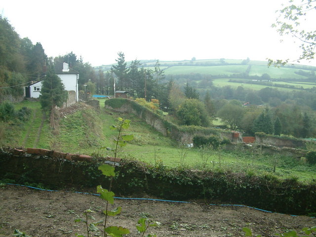
Ash Plantation is a beautiful woodland located in the county of Devon, in southwestern England. It spans over a vast area and is recognized as one of the most picturesque and diverse forests in the region. The plantation is predominantly composed of ash trees, hence its name, which create a dense and enchanting canopy throughout the area.

The plantation is a haven for nature enthusiasts and outdoor adventurers alike. Its well-maintained pathways and trails offer visitors the opportunity to explore the forest's wonders on foot or by bike. The terrain is relatively flat, making it accessible to people of all ages and fitness levels.

Within Ash Plantation, there is an abundance of wildlife. The forest provides a natural habitat for various species, including birds, squirrels, and deer. Birdwatchers will be delighted by the presence of diverse avian species, while those with a keen eye may spot elusive mammals amidst the trees.

The beauty of Ash Plantation is not limited to its flora and fauna. The forest also features a small lake, which adds to its tranquil charm. Visitors can take leisurely strolls around the lake or find a peaceful spot to sit and enjoy the serene surroundings.

Overall, Ash Plantation in Devon is a true gem for nature lovers seeking a peaceful retreat. With its flourishing ash trees, diverse wildlife, and serene atmosphere, it offers a rejuvenating experience for all who venture into its woodland embrace.

If you have any feedback on the listing, please let us know in the comments section below.

Ash Plantation Images

Images are sourced within 2km of 51.088399/-4.0360991 or Grid Reference SS5734. Thanks to Geograph Open Source API. All images are credited.

Barnstaple estate Forches housing estates in Barnstaple.
Barnstaple estate
Forches housing estates in Barnstaple.
Barnstaple fast food Strategically situated beside one of the main roads of Barnstaple.
Barnstaple fast food
Strategically situated beside one of the main roads of Barnstaple.
Barnstaple street There's a lot of houses in Barnstaple with this brickwork style.
Barnstaple street
There's a lot of houses in Barnstaple with this brickwork style.
Almshouses and Church, Pilton Pevsner says that these Almshouses were built in 1849 in 'pretty-imitation Tudor' style. St Mary's Church is behind them.
Almshouses and Church, Pilton
Pevsner says that these Almshouses were built in 1849 in 'pretty-imitation Tudor' style. St Mary's Church is behind them.
Tesco Walkway through the carpark
Tesco
Walkway through the carpark
Pannier Market, Barnstaple A view of the market along Butchers Row. It was opened in 1855. A history of the market can be found here: <span class="nowrap"><a title="http://barnstaplepanniermarket.co.uk/history.asp" rel="nofollow ugc noopener" href="http://barnstaplepanniermarket.co.uk/history.asp">Link</a><img style="margin-left:2px;" alt="External link" title="External link - shift click to open in new window" src="https://s1.geograph.org.uk/img/external.png" width="10" height="10"/></span>
Pannier Market, Barnstaple
A view of the market along Butchers Row. It was opened in 1855. A history of the market can be found here: LinkExternal link
Pannier Market, Barnstaple An interior view of the market during an antiques fair.
Pannier Market, Barnstaple
An interior view of the market during an antiques fair.
Brunswick Wharf and Gould's Yard, Barnstaple Brunswick Wharf belonged to Mr William Gould, a local builder and timber merchant.Here barges discharged sand and gravel dredged from the nearby Taw Estuary. Mr Gould's residence, "Northgate House", stood between the warehouse in the picture and North Walk/Rolle St. Until it closed in 1935, the Lynton and Barnstaple Railway track ran between the warehouse and Northgate House and crossed Rolle St by a gate controlled crossing.
Brunswick Wharf and Gould's Yard, Barnstaple
Brunswick Wharf belonged to Mr William Gould, a local builder and timber merchant.Here barges discharged sand and gravel dredged from the nearby Taw Estuary. Mr Gould's residence, "Northgate House", stood between the warehouse in the picture and North Walk/Rolle St. Until it closed in 1935, the Lynton and Barnstaple Railway track ran between the warehouse and Northgate House and crossed Rolle St by a gate controlled crossing.
Grosvenor Church, Barnstaple. Formerly the railway goods shed at the Great Western Railway, Victoria Road station yard, Barnstaple. This was the terminus of the Taunton to Barnstaple Railway which closed in the 1960s. The building is now used as a church and community meeting hall. Behind the wall on the left were the railway cattle pens.
Grosvenor Church, Barnstaple.
Formerly the railway goods shed at the Great Western Railway, Victoria Road station yard, Barnstaple. This was the terminus of the Taunton to Barnstaple Railway which closed in the 1960s. The building is now used as a church and community meeting hall. Behind the wall on the left were the railway cattle pens.
Kingdon's Gardens Kingdon's Gardens are reached by a public footpath, part of which is called Smoky House Lane. A pleasant walk from Barnstaple with the River Yeo running through the valley below to the south of the path.
Kingdon's Gardens
Kingdon's Gardens are reached by a public footpath, part of which is called Smoky House Lane. A pleasant walk from Barnstaple with the River Yeo running through the valley below to the south of the path.
Barnstaple: Boutport Street Looking north-north-west with Joy Street on the left
Barnstaple: Boutport Street
Looking north-north-west with Joy Street on the left
Barnstaple: towards the High Street In Joy Street, looking west-south-west. West Devon clay probably provided the material for the light-coloured bricks used on the building on the right
Barnstaple: towards the High Street
In Joy Street, looking west-south-west. West Devon clay probably provided the material for the light-coloured bricks used on the building on the right
Barnstaple: High Street Looking north-north-west by the junction with Joy Street
Barnstaple: High Street
Looking north-north-west by the junction with Joy Street
Barnstaple: Boutport Street At its southern end, looking north east, by the taxi rank
Barnstaple: Boutport Street
At its southern end, looking north east, by the taxi rank
Landkey: barn near Hall Farmhouse Looking north by an oak tree in new leaf. An old barn with a new roof
Landkey: barn near Hall Farmhouse
Looking north by an oak tree in new leaf. An old barn with a new roof
Burridge View of Burridge from across the valley.
Burridge
View of Burridge from across the valley.
A39 at Shirwell Cross A39 at Shirwell Cross
A39 at Shirwell Cross
Entrance to the hospital at Barnstaple Entrance to the hospital at Barnstaple
Entrance to the hospital at Barnstaple
Show me another place!

Ash Plantation is located at Grid Ref: SS5734 (Lat: 51.088399, Lng: -4.0360991)

Administrative County: Devon

District: North Devon

Police Authority: Devon and Cornwall

What 3 Words

///scorecard.pods.cooked. Near Barnstaple, Devon

Related Wikis

Burridge Fort

Burridge Fort is an Iron Age Hill fort situated to the North East of Barnstaple in Devon, England. The fort occupies a hill top approx 150 Metres above...

Yeotown, Goodleigh

Yeotown was a historic estate situated in the parish of Goodleigh, North Devon, about 1 1/2 miles north-east of the historic centre of Barnstaple. The...

Barnstaple Cemetery

Barnstaple Cemetery (properly Bear Street Cemetery) is the burial ground for the town of Barnstaple in Devon and is managed by North Devon Council.The...

North Devon District Hospital

North Devon District Hospital is an NHS district general hospital in the town of Barnstaple, North Devon, England run by Royal Devon University Healthcare...

Related Videos

Introduction to Experiential Tourism

Explore the essential ingredients needed to develop sustainable nature experiences and identify opportunities on how your ...

Hiking John O’ Groats to Land’s End | Daily Vlog | Day 57

Me and Di (my girlfriend) are hiking from John O' Groats to Land's End and wild camping all the way. This is a daily vlog of our ...

A Coastal Hiking Trip, Part I, 'A Brief Pit Stop at Barnstaple' by Sheila, July 20th 2020

After 2 trains I arrive at Barnstaple in time for my bus trip to Lynton where I will base myself for 3 days while exploring the coast ...

Walking tour Barnstaple town centre Devon - exploring and English beautiful town rich of history .

This walk in Barnstaple, Devon, England. We explore Barnstaple town centre and start our walk on Barnstaple High Street.

Nearby Amenities

Located within 500m of 51.088399,-4.0360991
Bench
Source: GPS
Lat/Long: 51.08468/-4.0395999
Bench
Source: GPS
Lat/Long: 51.0850085/-4.0372289
Bench
Lat/Long: 51.085407/-4.034371
Bench
Lat/Long: 51.0862915/-4.0343307
Bench
Source: GPS
Lat/Long: 51.0867094/-4.0348551
Bench
Source: GPS
Lat/Long: 51.0866529/-4.0363679
Bench
Source: GPS
Lat/Long: 51.0864558/-4.037772
Bench
Source: GPS
Lat/Long: 51.0863964/-4.0411701
Bench
Source: GPS
Lat/Long: 51.0859341/-4.0396318
Bench
Source: GPS
Lat/Long: 51.0854589/-4.041449
Leisure: picnic_table
Source: GPS
Lat/Long: 51.0856699/-4.041437
Leisure: picnic_table
Source: GPS
Lat/Long: 51.0856699/-4.0415551
Power: pole
Lat/Long: 51.0890086/-4.0420246
Power: pole
Lat/Long: 51.0894079/-4.0409946
Power: pole
Lat/Long: 51.0899866/-4.0395677
Power: pole
Lat/Long: 51.0901424/-4.0379155
Power: pole
Lat/Long: 51.0904692/-4.0341523
Power: pole
Lat/Long: 51.0905501/-4.0324143
Power: pole
Lat/Long: 51.0905046/-4.0316713
Power: pole
Lat/Long: 51.0904187/-4.0298528
The data included in this document is from www.openstreetmap.org. The data is made available under ODbL.

Have you been to Ash Plantation?

Leave your review of Ash Plantation below (or comments, questions and feedback).