South Common Plantation

Wood, Forest in Devon West Devon

England

South Common Plantation

West Devon : Woodland In the woodland with the River Tavy heading through.
West Devon : Woodland Credit: Lewis Clarke

South Common Plantation is a picturesque woodland area located in the county of Devon, England. Spread across a vast expanse, this plantation offers a serene escape from the hustle and bustle of city life. The woodland can be found close to the town of Woodbury and is easily accessible by both car and public transport.

The plantation is characterized by its rich biodiversity and stunning natural beauty. With a variety of tree species, including oak, beech, and birch, South Common Plantation is a haven for nature enthusiasts and wildlife lovers. The forest floor is covered with a carpet of vibrant wildflowers, providing a colorful backdrop to the towering trees above.

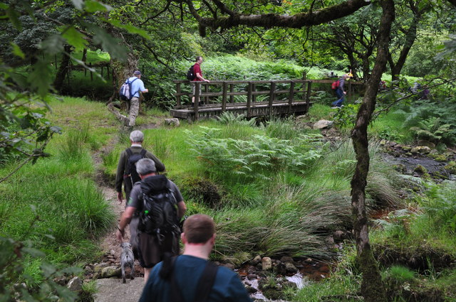
Visitors to South Common Plantation can enjoy a range of outdoor activities. The well-maintained footpaths that wind through the woodland offer an opportunity for leisurely walks and hikes, allowing visitors to immerse themselves in the tranquil surroundings. Birdwatchers can delight in spotting a plethora of avian species, including woodpeckers and owls, while woodland creatures such as squirrels and rabbits can often be seen darting between the trees.

The plantation is also home to a small picnic area, providing a perfect spot for families and friends to enjoy a leisurely lunch amidst the peaceful atmosphere. The area is well-maintained, with ample parking and clean facilities, ensuring a comfortable and enjoyable experience for all visitors.

South Common Plantation, with its natural beauty and abundance of wildlife, offers a place of respite and tranquility for all who venture into its leafy embrace.

If you have any feedback on the listing, please let us know in the comments section below.

South Common Plantation Images

Images are sourced within 2km of 50.607528/-4.0407454 or Grid Reference SX5580. Thanks to Geograph Open Source API. All images are credited.

West Devon : Woodland In the woodland with the River Tavy heading through.
West Devon : Woodland
In the woodland with the River Tavy heading through.
West Devon : Footpath Heading along the footpath with sticks in hand.
West Devon : Footpath
Heading along the footpath with sticks in hand.
West Devon : The River Tavy Looking across to the River Tavy on Dartmoor.
West Devon : The River Tavy
Looking across to the River Tavy on Dartmoor.
West Devon : Footpath A footpath heads through woodland along the River Tavy.
West Devon : Footpath
A footpath heads through woodland along the River Tavy.
West Devon : The River Tavy The River Tavy heading underneath some trees.
West Devon : The River Tavy
The River Tavy heading underneath some trees.
West Devon : Footpath A footpath heading through some woodland near the River Tavy.
West Devon : Footpath
A footpath heading through some woodland near the River Tavy.
West Devon : Footpath  & River The River Tavy with the signpost pointing the way.
West Devon : Footpath & River
The River Tavy with the signpost pointing the way.
West Devon : Footpath A footpath with a group of people going on a hike onto Dartmoor.
West Devon : Footpath
A footpath with a group of people going on a hike onto Dartmoor.
West Devon : Woodland A patch of woodland on Dartmoor in West Devon.
West Devon : Woodland
A patch of woodland on Dartmoor in West Devon.
West Devon : Footpath A muddy footpath heading up into the moorland.
West Devon : Footpath
A muddy footpath heading up into the moorland.
West Devon : Grassy Field A grassy field in the West Devon countryside.
West Devon : Grassy Field
A grassy field in the West Devon countryside.
West Devon : Farm Track A farm track heads from here towards Standon Farm.
West Devon : Farm Track
A farm track heads from here towards Standon Farm.
West Devon : Dartmoor Scenery Looking out across the countryside and moorland of Dartmoor.
West Devon : Dartmoor Scenery
Looking out across the countryside and moorland of Dartmoor.
West Devon : Brousentor Farm A private track and gate in front of Brousentor Farm on Dartmoor.
West Devon : Brousentor Farm
A private track and gate in front of Brousentor Farm on Dartmoor.
West Devon : Dartmoor Scenery Looking across the moorland on Dartmoor.
West Devon : Dartmoor Scenery
Looking across the moorland on Dartmoor.
West Devon : Dartmoor Scenery Looking out and across the moorland of Dartmoor.
West Devon : Dartmoor Scenery
Looking out and across the moorland of Dartmoor.
West Devon : Dartmoor Scenery Looking across the moorland scenery in West Devon.
West Devon : Dartmoor Scenery
Looking across the moorland scenery in West Devon.
West Devon : Baggator At Baggator on Dartmoor and a quick break for a snack and a drink.
West Devon : Baggator
At Baggator on Dartmoor and a quick break for a snack and a drink.
Show me another place!

South Common Plantation is located at Grid Ref: SX5580 (Lat: 50.607528, Lng: -4.0407454)

Administrative County: Devon

District: West Devon

Police Authority: Devon and Cornwall

What 3 Words

///released.erupt.clay. Near Princetown, Devon

Related Wikis

Cut Hill

Cut Hill is a hill in North Dartmoor in the southwest English county of Devon. At 603 metres high, it is the joint third highest peak in Devon and Dartmoor...

Great Mis Tor

Great Mis Tor is a hill with a rocky outcrop situated in Dartmoor. It has been called one of the grandest hills in Devon, and lies above the River Walkham...

Devon United Mine

Devon United Mine (grid reference SX521795) is a 1.0 hectare geological Site of Special Scientific Interest in Devon, England, notified in 1987. ��2�...

Cudlipptown

Cudlipptown or Cudliptown is a small village located near the western edge of Dartmoor National Park, northeast of Tavistock, and approximately one mile...

Nearby Amenities

Located within 500m of 50.607528,-4.0407454
Field Telephone Connection
Access: private
Description: Military field telephone connection socket in a concrete box with metal door.
Man Made: telephone
Military: field_telephone
Operator: Ministry of Defence
Source: GPS
Usage: military
Lat/Long: 50.6045601/-4.0396553
The data included in this document is from www.openstreetmap.org. The data is made available under ODbL.

Have you been to South Common Plantation?

Leave your review of South Common Plantation below (or comments, questions and feedback).