Courtleigh Wood

Wood, Forest in Devon West Devon

England

Courtleigh Wood

Tarka Trail shared path near Meeth
Tarka Trail shared path near Meeth Credit: David Smith

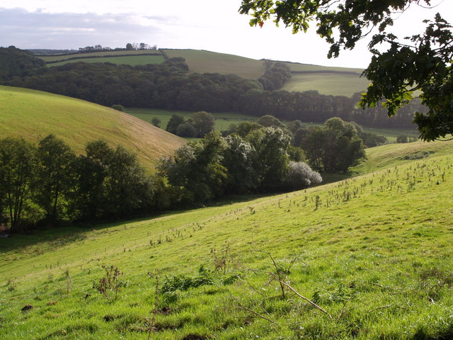
Courtleigh Wood, located in Devon, England, is a picturesque and enchanting forest that spans over a vast area. The wood is nestled in the heart of Devon, surrounded by rolling hills and meandering streams, offering a serene and tranquil atmosphere for visitors to enjoy.

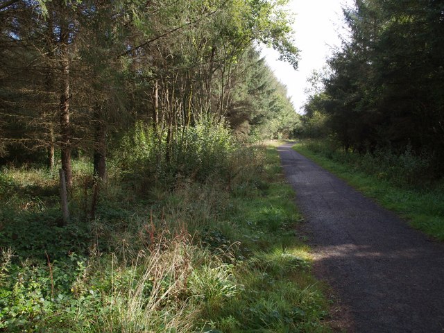
Covered with a variety of deciduous and evergreen trees, Courtleigh Wood is a haven for nature enthusiasts and hikers alike. The wood is predominantly composed of oak, beech, and pine trees, which provide a rich and diverse ecosystem for various wildlife species to thrive. Visitors can expect to encounter a plethora of bird species, including woodpeckers, owls, and robins, filling the air with their melodious songs.

The forest has an extensive network of footpaths and trails, allowing visitors to explore its beauty at their own pace. These trails are well-maintained and offer breathtaking views of the surrounding countryside. Additionally, the wood boasts several picnic spots and clearings where families and friends can relax and enjoy a peaceful meal amidst the natural beauty.

The wood is also home to a diverse range of flora and fauna, with wildflowers carpeting the forest floor during the spring and summer months. Bluebells, primroses, and foxgloves are just a few examples of the vibrant flowers that bloom, creating a colorful and captivating display.

Courtleigh Wood is a truly magical place, offering a sanctuary for both wildlife and humans alike. With its scenic beauty, abundant wildlife, and peaceful ambience, it is a must-visit destination for nature lovers and those seeking a serene escape from the hustle and bustle of everyday life.

If you have any feedback on the listing, please let us know in the comments section below.

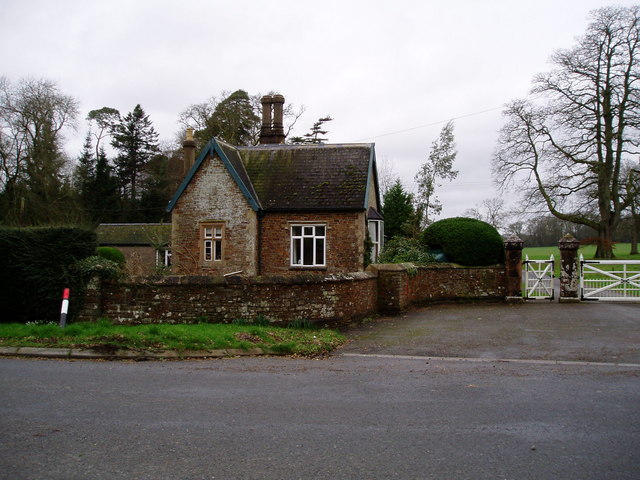
Courtleigh Wood Images

Images are sourced within 2km of 50.85887/-4.0763411 or Grid Reference SS5308. Thanks to Geograph Open Source API. All images are credited.

Tarka Trail shared path near Meeth
Ford and footbridge on Tarka Trail The ford is for cyclists
Ford and footbridge on Tarka Trail
The ford is for cyclists
Gatehouse of the Clinton Estate, Merton This is one of two gatehouses of the Clinton Estate in Merton
Gatehouse of the Clinton Estate, Merton
This is one of two gatehouses of the Clinton Estate in Merton
Leytown A farm in a shallow valley west of the Torridge, seen from the Tarka Trail as it follows the lane from Broadmead to New Bridge.
Leytown
A farm in a shallow valley west of the Torridge, seen from the Tarka Trail as it follows the lane from Broadmead to New Bridge.
Bourna A thatched farmhouse by the A386, and sited where the Tarka Trail runs alongside the main road for a short distance.
Bourna
A thatched farmhouse by the A386, and sited where the Tarka Trail runs alongside the main road for a short distance.
Bourna Another view of the farmhouse shown in <a href="https://www.geograph.org.uk/photo/569611">SS5410 : Bourna</a>. The land behind slopes gently away towards the River Torridge. Seen from the Tarka Trail as it passes along the A386.
Bourna
Another view of the farmhouse shown in SS5410 : Bourna. The land behind slopes gently away towards the River Torridge. Seen from the Tarka Trail as it passes along the A386.
Iddesleigh: The Torridge Seen just below its confluence with the Okement, near Bridge Town. If there was a bridge here, and the indications are that there was, there is no evidence on the ground today. Looking roughly north west
Iddesleigh: The Torridge
Seen just below its confluence with the Okement, near Bridge Town. If there was a bridge here, and the indications are that there was, there is no evidence on the ground today. Looking roughly north west
Iddesleigh: on the bank of the Torridge Looking west, with snowdrops on the bank; below the river’s confluence with its tributary the Okement
Iddesleigh: on the bank of the Torridge
Looking west, with snowdrops on the bank; below the river’s confluence with its tributary the Okement
View from Friar's Hele Cross A view NNE from the ridge north of the Torridge. Fields slope towards an unnamed wood.
View from Friar's Hele Cross
A view NNE from the ridge north of the Torridge. Fields slope towards an unnamed wood.
St Michael's church, Meeth Plenty of Norman work is evident. "This is a very simple church but it has some good quality detail and the C19 restoration has added to rather than detracted from the building" <span class="nowrap"><a title="http://www.britishlistedbuildings.co.uk/en-93295-church-of-st-michael-meeth" rel="nofollow ugc noopener" href="http://www.britishlistedbuildings.co.uk/en-93295-church-of-st-michael-meeth">Link</a><img style="margin-left:2px;" alt="External link" title="External link - shift click to open in new window" src="https://s1.geograph.org.uk/img/external.png" width="10" height="10"/></span> . Seen from the edge of the churchyard, which is set up above the main road.
St Michael's church, Meeth
Plenty of Norman work is evident. "This is a very simple church but it has some good quality detail and the C19 restoration has added to rather than detracted from the building" LinkExternal link . Seen from the edge of the churchyard, which is set up above the main road.
Side valley and Torridge valley A deep little side valley, with trees following the stream, runs down to meet the Torridge. Seen from a track east of Meeth.
Side valley and Torridge valley
A deep little side valley, with trees following the stream, runs down to meet the Torridge. Seen from a track east of Meeth.
Field beside Round Pole Plantation The plantation is to the right across the field. The mound on the extreme left is part of Meeth Clay Tip. Seen in torrential rain from Meeth Footpath 2, here followed by the cycle track version of the Tarka Trail.
Field beside Round Pole Plantation
The plantation is to the right across the field. The mound on the extreme left is part of Meeth Clay Tip. Seen in torrential rain from Meeth Footpath 2, here followed by the cycle track version of the Tarka Trail.
Meeth Halt (disused) The North Devon and Cornwall Junction Light Railway (<span class="nowrap"><a title="http://en.wikipedia.org/wiki/North_Devon_and_Cornwall_Junction_Light_Railway" rel="nofollow ugc noopener" href="http://en.wikipedia.org/wiki/North_Devon_and_Cornwall_Junction_Light_Railway">Link</a><img style="margin-left:2px;" alt="External link" title="External link - shift click to open in new window" src="https://s1.geograph.org.uk/img/external.png" width="10" height="10"/></span> ) closed in 1965. This must always have been a tiny station. It now serves as a starting point for a cyclepath along the former line as a branch of the Tarka Trail.
Meeth Halt (disused)
The North Devon and Cornwall Junction Light Railway (LinkExternal link ) closed in 1965. This must always have been a tiny station. It now serves as a starting point for a cyclepath along the former line as a branch of the Tarka Trail.
Across the Torridge valley A view from the track to the Shuteslades leading off the A386. The wooded valley of the Torridge crosses the photo; the river is flowing to the left. The wood to the right on the far side is Great Parkdown Wood. The chimney pot of Higher Shuteslade Farm pokes up above the field. (The 1:25000 map called the two farms here "Shetslade", and that is the name of an adjacent wood; other sources and local signs go for Shuteslade.) The prominent green barn is at Tockley, in SS5510.
Across the Torridge valley
A view from the track to the Shuteslades leading off the A386. The wooded valley of the Torridge crosses the photo; the river is flowing to the left. The wood to the right on the far side is Great Parkdown Wood. The chimney pot of Higher Shuteslade Farm pokes up above the field. (The 1:25000 map called the two farms here "Shetslade", and that is the name of an adjacent wood; other sources and local signs go for Shuteslade.) The prominent green barn is at Tockley, in SS5510.
Countryside west of the Torridge Looking across fields from the A386 north of Stone Cross. The trees on the right follow a small valley down to the nearby Torridge. The buildings at Lovistone Barton are in SS5410.
Countryside west of the Torridge
Looking across fields from the A386 north of Stone Cross. The trees on the right follow a small valley down to the nearby Torridge. The buildings at Lovistone Barton are in SS5410.
Tarka Trail junction The trail follows the line of the North Devon and Cornwall Junction Light Railway for a long distance across North Devon; on the left it reaches the last hundred metres before veering off towards the Torridge. On the right is a cyclepath which takes a different route around the clay pits to reach <a href="https://www.geograph.org.uk/photo/567424">SS5407 : Meeth Halt (disused)</a>.
Tarka Trail junction
The trail follows the line of the North Devon and Cornwall Junction Light Railway for a long distance across North Devon; on the left it reaches the last hundred metres before veering off towards the Torridge. On the right is a cyclepath which takes a different route around the clay pits to reach SS5407 : Meeth Halt (disused).
Tarka Trail in Foxes' Covert The trail follows the line of the North Devon and Cornwall Junction Light Railway through woodland as it approaches the Little Mere River.
Tarka Trail in Foxes' Covert
The trail follows the line of the North Devon and Cornwall Junction Light Railway through woodland as it approaches the Little Mere River.
Path to church, Meeth "A cobbled path, made in 1818 from Torridge river pebbles by the French prisoners from Dartmoor prison at the time of the Napoleonic wars, leads past old lime trees to the early Norman porch" (<span class="nowrap"><a title="http://www.hatherleigh.net/meeth.asp" rel="nofollow ugc noopener" href="http://www.hatherleigh.net/meeth.asp">Link</a><img style="margin-left:2px;" alt="External link" title="External link - shift click to open in new window" src="https://s1.geograph.org.uk/img/external.png" width="10" height="10"/></span> ). A similar path exists at <a href="https://www.geograph.org.uk/photo/567493">SS5311 : St James the Less church, Huish</a>, presumably of the same origin.
Path to church, Meeth
"A cobbled path, made in 1818 from Torridge river pebbles by the French prisoners from Dartmoor prison at the time of the Napoleonic wars, leads past old lime trees to the early Norman porch" (LinkExternal link ). A similar path exists at SS5311 : St James the Less church, Huish, presumably of the same origin.
Show me another place!

Courtleigh Wood is located at Grid Ref: SS5308 (Lat: 50.85887, Lng: -4.0763411)

Administrative County: Devon

District: West Devon

Police Authority: Devon and Cornwall

What 3 Words

///soaps.thickened.saddens. Near Hatherleigh, Devon

Nearby Locations

Meeth Courtleigh Wood

Related Wikis

Meeth Halt railway station

Opened in 1925, Meeth Halt was a small railway station on the North Devon and Cornwall Junction Light Railway, a private line until it became part of the...

Meeth

Meeth is a small village roughly 13.5 km (8.4 mi) north-northwest of Okehampton and 40.7 km (25.3 mi) west-northwest of Exeter. It lies to the west of...

River Okement

The River Okement is a tributary of the River Torridge in Devon, England. It rises at two places in Dartmoor, as the West Okement and the East Okement...

Huish, Torridge

Huish (anciently Hiwis) is a small village, civil parish and former manor in the Torridge district of Devon, England. The eastern boundary of the parish...

Nearby Amenities

Located within 500m of 50.85887,-4.0763411
The data included in this document is from www.openstreetmap.org. The data is made available under ODbL.

Have you been to Courtleigh Wood?

Leave your review of Courtleigh Wood below (or comments, questions and feedback).