Coldharbour Wood

Wood, Forest in Devon West Devon

England

Coldharbour Wood

Baptist Chapel, High Street, Hatherleigh Dated 1879. Now the Vine Chapel according to the sign, but their website <span class="nowrap"><a title="http://www.findachurch.co.uk/churches/ss/ss50/vine/states" rel="nofollow ugc noopener" href="http://www.findachurch.co.uk/churches/ss/ss50/vine/states">Link</a><img style="margin-left:2px;" alt="External link" title="External link - shift click to open in new window" src="https://s1.geograph.org.uk/img/external.png" width="10" height="10"/></span> that they now meet in a modern community centre down by the main road.  The old chapel is a church hall that other organisations can hire. They are still Baptists, but are "experimenting with the concept of church with choice".
Baptist Chapel, High Street, Hatherleigh Credit: Humphrey Bolton

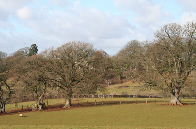
Coldharbour Wood is a beautiful woodland located in the county of Devon, England. Covering an area of approximately 50 acres, this enchanting forest is nestled in the heart of the picturesque Dartmoor National Park. It is situated near the town of Bovey Tracey, offering visitors a tranquil escape from the hustle and bustle of everyday life.

The wood is predominantly composed of native broadleaf trees, including oak, beech, and birch, creating a rich and diverse ecosystem. The dense canopy provides a haven for a wide array of wildlife, making it a popular spot for nature enthusiasts and birdwatchers.

Trails meander through the woodland, allowing visitors to explore its natural beauty at their own pace. The paths are well-maintained and suitable for walkers of all abilities, making Coldharbour Wood an ideal location for a leisurely stroll or a more adventurous hike.

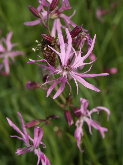
One of the highlights of Coldharbour Wood is the abundance of bluebells that carpet the forest floor during the spring months. This annual spectacle attracts visitors from far and wide, creating a visually stunning landscape and a fragrant floral experience.

The wood is managed by the Dartmoor National Park Authority, ensuring its preservation and protection for future generations to enjoy. Visitors are reminded to respect the natural environment and wildlife, adhering to any guidelines or restrictions in place.

Overall, Coldharbour Wood is a captivating destination for those seeking peace and tranquility in the heart of the Devon countryside. Its natural beauty, diverse wildlife, and well-maintained trails make it a must-visit location for nature lovers and outdoor enthusiasts.

If you have any feedback on the listing, please let us know in the comments section below.

Coldharbour Wood Images

Images are sourced within 2km of 50.811958/-4.0814423 or Grid Reference SS5303. Thanks to Geograph Open Source API. All images are credited.

Baptist Chapel, High Street, Hatherleigh Dated 1879. Now the Vine Chapel according to the sign, but their website <span class="nowrap"><a title="http://www.findachurch.co.uk/churches/ss/ss50/vine/states" rel="nofollow ugc noopener" href="http://www.findachurch.co.uk/churches/ss/ss50/vine/states">Link</a><img style="margin-left:2px;" alt="External link" title="External link - shift click to open in new window" src="https://s1.geograph.org.uk/img/external.png" width="10" height="10"/></span> that they now meet in a modern community centre down by the main road.  The old chapel is a church hall that other organisations can hire. They are still Baptists, but are "experimenting with the concept of church with choice".
Baptist Chapel, High Street, Hatherleigh
Dated 1879. Now the Vine Chapel according to the sign, but their website LinkExternal link that they now meet in a modern community centre down by the main road. The old chapel is a church hall that other organisations can hire. They are still Baptists, but are "experimenting with the concept of church with choice".
Hatherleigh Fire Station Hatherleigh Fire Station, Hill Meadow, Bridge Street, Hatherleigh, Devon.
Hatherleigh Fire Station
Hatherleigh Fire Station, Hill Meadow, Bridge Street, Hatherleigh, Devon.
St John the Baptist's Church, Hatherleigh
Hatherleigh: The George Seen from the town car park entrance. Hoskins [W G Hoskins, Devon, 1992] suggests this inn may have originally been the court house belonging to the abbots of Tavistock: they held the manor from circa 980 to the dissolution. Parts of the inn’s fabric are thought to date from the 15th century. It stands near the church and the site of the old market
Hatherleigh: The George
Seen from the town car park entrance. Hoskins [W G Hoskins, Devon, 1992] suggests this inn may have originally been the court house belonging to the abbots of Tavistock: they held the manor from circa 980 to the dissolution. Parts of the inn’s fabric are thought to date from the 15th century. It stands near the church and the site of the old market
Hatherleigh: St John the Baptist’s church View south with Dartmoor just visible in the distance. Red sandstone forms the bulk of the structure, which dates from the 15th century
Hatherleigh: St John the Baptist’s church
View south with Dartmoor just visible in the distance. Red sandstone forms the bulk of the structure, which dates from the 15th century
Hatherleigh: towards Strawbridge Farmland north west of the town
Hatherleigh: towards Strawbridge
Farmland north west of the town
Field, hedge and trees beside A386 A chevron sign and bend sign (turned round by someone to face the wrong way) on the A386 are just visible on the extreme right. A triangular field beyond the hedge is largely enclosed by small woods; Grey's Copse on the far side is in <a href="https://www.geograph.org.uk/gridref/SY5402">SY5402</a>.
Field, hedge and trees beside A386
A chevron sign and bend sign (turned round by someone to face the wrong way) on the A386 are just visible on the extreme right. A triangular field beyond the hedge is largely enclosed by small woods; Grey's Copse on the far side is in SY5402.
Basset's Cross The cross is on a wide verge beside the junction of the A386 and the B3216. In the background, the A386 heads south towards Folly Gate.
Basset's Cross
The cross is on a wide verge beside the junction of the A386 and the B3216. In the background, the A386 heads south towards Folly Gate.
Pond on Hatherleigh Moor Hatherleigh Moor is access land, and this pond is in the extreme southwest corner, close to Hatherleigh Moor Brook (off to the left).
Pond on Hatherleigh Moor
Hatherleigh Moor is access land, and this pond is in the extreme southwest corner, close to Hatherleigh Moor Brook (off to the left).
Field with bullocks near River Lew Hatherleigh Footpath 6 crosses the field which the bullocks are in, and which borders the river on the right of the picture by the tall trees. Beyond are buildings on the western outskirts of Hatherleigh.
Field with bullocks near River Lew
Hatherleigh Footpath 6 crosses the field which the bullocks are in, and which borders the river on the right of the picture by the tall trees. Beyond are buildings on the western outskirts of Hatherleigh.
Track near Rookes This pleasant-looking track sets off between hedges diagonally from the lane between Gribbleford Bridge and Hatherleigh, but is not a right of way, although it would appear to connect with Hatherleigh Footpath 9 at Hannaborough.
Track near Rookes
This pleasant-looking track sets off between hedges diagonally from the lane between Gribbleford Bridge and Hatherleigh, but is not a right of way, although it would appear to connect with Hatherleigh Footpath 9 at Hannaborough.
Field edge near Holepark A marshy entrance to this field off the Hatherleigh-Gribbleford Bridge lane, which straddles a northing gridline. The wooded area on the right borders Hatherleigh Footpath 11 to Holepark.
Field edge near Holepark
A marshy entrance to this field off the Hatherleigh-Gribbleford Bridge lane, which straddles a northing gridline. The wooded area on the right borders Hatherleigh Footpath 11 to Holepark.
Ragged Robin Lychnis flos-cuculi at Basset's Cross. Always a reassuring sight, as it seems to be increasingly infrequent in South Devon. Plenty grows around Hatherleigh, however.
Ragged Robin
Lychnis flos-cuculi at Basset's Cross. Always a reassuring sight, as it seems to be increasingly infrequent in South Devon. Plenty grows around Hatherleigh, however.
Gateway on Hatherleigh Footpath 7 The path leaves the access land at Hatherleigh Moor through this gate on its way towards the A386.
Gateway on Hatherleigh Footpath 7
The path leaves the access land at Hatherleigh Moor through this gate on its way towards the A386.
Hatherleigh Cricket Club This gate is by the A3072 to Holsworthy, but the entrance is now off to the right, from the same road that leads to the farm at Littlewood.
Hatherleigh Cricket Club
This gate is by the A3072 to Holsworthy, but the entrance is now off to the right, from the same road that leads to the farm at Littlewood.
River Lew below Hatherleigh The Lew impinges on a rocky outcrop southwest of Strawbridge. This view, with the river approaching the camera, is from Hatherleigh Footpath 1, which teeters above a river cliff.
River Lew below Hatherleigh
The Lew impinges on a rocky outcrop southwest of Strawbridge. This view, with the river approaching the camera, is from Hatherleigh Footpath 1, which teeters above a river cliff.
Goosehams The ruins of a farm building, possibly a farmhouse, close to Hatherleigh Footpath 5. As is common, the chimney stack is the last prominent feature to survive. Although there is some stone, much of the remains are composed of soft cob which is rapidly disintegrating. Beyond, the land descends towards Pulworthy Brook.
Goosehams
The ruins of a farm building, possibly a farmhouse, close to Hatherleigh Footpath 5. As is common, the chimney stack is the last prominent feature to survive. Although there is some stone, much of the remains are composed of soft cob which is rapidly disintegrating. Beyond, the land descends towards Pulworthy Brook.
Beside Pulworthy Brook Taken from Hatherleigh Footpath 3a as it crosses a meadow beside the stream, to reach the line of the disused Halwill-Hatherleigh railway. The farm building appearing at the extreme right is at Furzehill.
Beside Pulworthy Brook
Taken from Hatherleigh Footpath 3a as it crosses a meadow beside the stream, to reach the line of the disused Halwill-Hatherleigh railway. The farm building appearing at the extreme right is at Furzehill.
Show me another place!

Coldharbour Wood is located at Grid Ref: SS5303 (Lat: 50.811958, Lng: -4.0814423)

Administrative County: Devon

District: West Devon

Police Authority: Devon and Cornwall

What 3 Words

///basics.glee.pointer. Near Hatherleigh, Devon

Related Wikis

Hatherleigh

Hatherleigh is a small market town in west Devon, England. It hosts an arts festival in July, and a carnival in November featuring two flaming tar barrel...

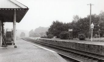
Hatherleigh railway station

Hatherleigh Railway Station was a station on the North Devon and Cornwall Junction Light Railway between Torrington and Halwill Junction, serving the town...

River Lew

The River Lew can refer to either of two short rivers that lie close to each other in Devon, England. The more northerly of the two rises just south of...

Meeth

Meeth is a small village roughly 13.5 km (8.4 mi) north-northwest of Okehampton and 40.7 km (25.3 mi) west-northwest of Exeter. It lies to the west of...

Nearby Amenities

Located within 500m of 50.811958,-4.0814423
Power: pole
Lat/Long: 50.8159512/-4.0846047
Power: pole
Lat/Long: 50.8161529/-4.0834862
Power: pole
Lat/Long: 50.8164172/-4.0819627
Direction: SSW
Generator Method: photovoltaic
Generator Output Electricity: yes
Generator Solar Modules: 8
Generator Source: solar
Generator Type: solar_photovoltaic_panel
Location: roof
Power: generator
Lat/Long: 50.8162515/-4.0802264
Direction: SSW
Generator Method: photovoltaic
Generator Output Electricity: yes
Generator Solar Modules: 8
Generator Source: solar
Generator Type: solar_photovoltaic_panel
Location: roof
Power: generator
Lat/Long: 50.8161566/-4.0801593
Direction: SSW
Generator Method: photovoltaic
Generator Output Electricity: yes
Generator Solar Modules: 8
Generator Source: solar
Generator Type: solar_photovoltaic_panel
Location: roof
Power: generator
Lat/Long: 50.8161159/-4.0800896
Direction: ESE
Generator Method: photovoltaic
Generator Output Electricity: yes
Generator Solar Modules: 8
Generator Source: solar
Generator Type: solar_photovoltaic_panel
Location: roof
Power: generator
Lat/Long: 50.8162244/-4.0797516
Direction: ESE
Generator Method: photovoltaic
Generator Output Electricity: yes
Generator Solar Modules: 6
Generator Source: solar
Generator Type: solar_photovoltaic_panel
Location: roof
Power: generator
Lat/Long: 50.8162701/-4.0797597
Direction: SSW
Generator Method: photovoltaic
Generator Output Electricity: yes
Generator Solar Modules: 12
Generator Source: solar
Generator Type: solar_photovoltaic_panel
Location: roof
Power: generator
Lat/Long: 50.8139753/-4.0812299
Power: pole
Lat/Long: 50.8141828/-4.0778281
Power: pole
Lat/Long: 50.8148005/-4.0772192
Power: pole
Lat/Long: 50.8123923/-4.0796694
Power: pole
Lat/Long: 50.8134973/-4.0785241
Power: pole
Lat/Long: 50.8141311/-4.078272
Power: pole
Lat/Long: 50.8130499/-4.0821639
Power: pole
Lat/Long: 50.812594/-4.0836874
Power: pole
Lat/Long: 50.8120347/-4.0853396
Power: pole
Lat/Long: 50.8111229/-4.0882686
The data included in this document is from www.openstreetmap.org. The data is made available under ODbL.

Have you been to Coldharbour Wood?

Leave your review of Coldharbour Wood below (or comments, questions and feedback).